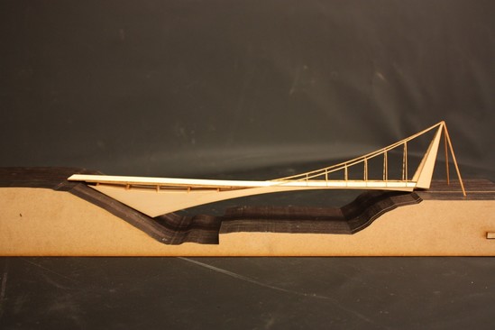
 An illustration of the "Stretch" bridge design option for Sullivan's Crossing facing west over I-84.
By David Backes, Portland Bureau of Transportation
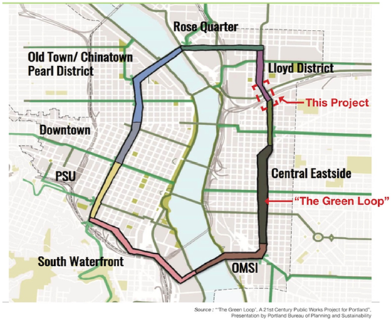
(Dec. 1, 2017) In 2021, a new bridge will reach across I-84, connecting the
Lloyd District with the Central Eastside Industrial District. Sullivan’s
Crossing (as it’s called now) will allow people to stroll and roll separate
from motor vehicle traffic, all while taking in stunning views of downtown
Portland. In the event of a major earthquake, Sullivan’s Crossing’s robust
engineering will also allow it to remain functional and provide access for
emergency vehicles.
This stress-free biking and walking route between the two growing districts
provides a much-needed connection across the natural barrier of Sullivan’s
Gulch and human-made barriers below, I-84 and the Union Pacific Railroad. Today,
people driving between the two districts have several nearby options (Grand,
MLK, 12th Avenue), but safe, comfortable options for people biking
and walking are limited. Sullivan’s Crossing bridges that gap, while also
completing a key link in the Green Loop.
Determining the south
landing location – 7th or 8th Avenue
The north side landing of Sullivan’s Crossing is NE 7th
Avenue, due to its existing bike lanes and through connection to NE Lloyd
Boulevard. On the south side, the bridge will either land at NE 8th
Avenue & NE Glisan Street (Alignment 1) or NE 7th Ave & NE
Flanders Street (Alignment 2). Both alignment alternatives have been studied,
and both have advantages and tradeoffs—see below for a high-level overview (and
for a more detailed look download
the full report here).
The final alignment decision will be made in December, following further analysis, conversations with stakeholders, and feedback
received at the open house.
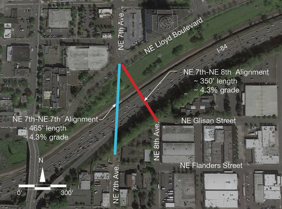
NE 8th
Avenue Alignment Snapshot
- Shorter span is less
expensive to build (+)
- PBOT would need to acquire
right of way (-)
- Sightlines of the bridge
from the south side are not as continuous as with 7th (-)
NE 7th
Avenue Alignment Snapshot
- Longer span is more
expensive to build (-)
- PBOT owns more right of way
here and would not need to acquire property (+)
- Likely better sightlines of
the bridge from the south side (+)
Exploring different
bridge types
It isn’t possible to fully vet bridge types until an
alignment alternative has been selected, but preliminary assessment of bridge
types has already begun. In 2016, PBOT worked with consultants to prepare an
alternatives analysis of different bridge types and alignments. From this
analysis, one preferred bridge type emerged, which is now being compared to additional
options.
Models of these bridge types are shown below as conceptual
examples of what the new crossing might look like.
Join us at the open house to see the models and learn more
about the project on Tuesday, December 5, 2017 from 4:00 – 6:30 p.m. (drop in
anytime) at Oregon Metro, 2nd floor lobby (600 NE Grand Ave, 97232). We’ll have
snacks. Click here to
RSVP to the event on Facebook.
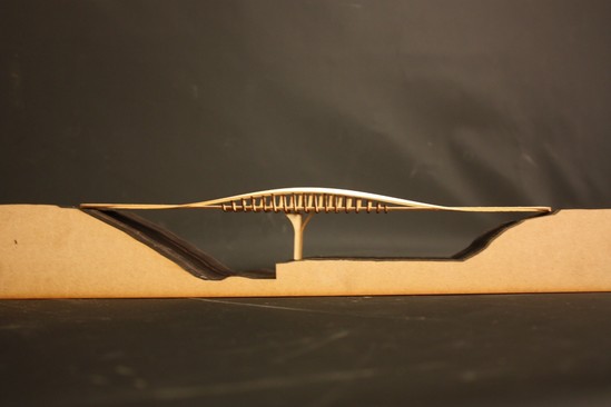
Here are the bridge designs being considered for Sullivan’s
Crossing (all designs are looking eastbound up I-84, away from downtown Portland):
1. “Stretch” expresses the asymmetry of the site by taking advantage of the embankment on the north side of the alignment:
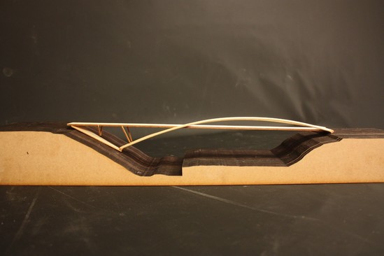
2. “Skip,”
developed during phase one of the project, appears to lightly skip across
Sullivan’s Gulch:
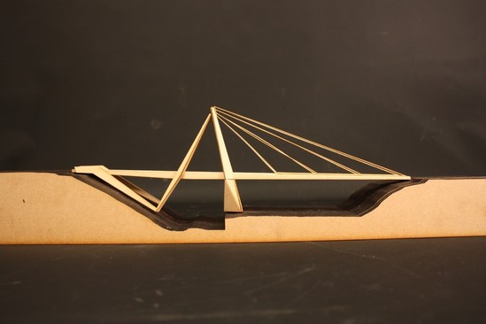
3. “Reach” is iconic in its tower expression, serving as a gateway marker for both entering and leaving the City of Portland:
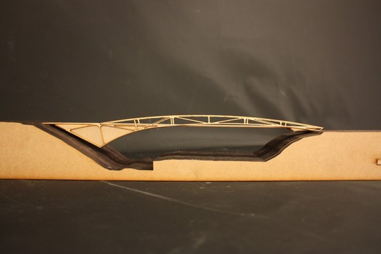
4. “Leap” takes advantage of the ability to anchor into the northern embankment to create an expressive truss structure that seems to spring from the ground:
5. “Weave” creates an iconic structural expression that weaves together the deck and girders to create an integrated fluid form.
Stay up to date
Visit
the Sullivan's Crossing project website
Join us at the open house on Tuesday, December 5th, 4:00 - 6:30 p.m. at Metro. Click here for details.
|