|
|
|
|
|
|
Year-to-date deaths and more precise locations in latest update
|
|
|
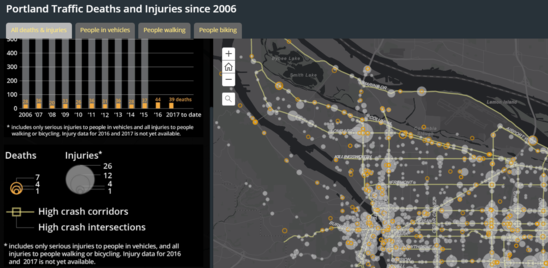
 An interactive crash map of Portland traffic deaths and serious injuries now includes 2015 data, the most recent year for which complete information is available, as well as more information about crash dates and contributing factors.
The refreshed map also includes data on traffic deaths that occurred in 2016 and year-to-date in 2017; serious injury data for 2016 and 2017 is not yet available. PBOT will update the map when deadly crashes occur.
In addition, the revised map allows users to see the locations of crashes. When zoomed out, crashes are grouped to the nearest intersection; when zoomed in, the updated map shows specific crash locations.
(Please note that location data is approximate; coordinates have become more precise in recent years but are still subject to error. Location data and crash factors for years 2016 and 2017 is based on preliminary police reports and has not been finalized.)
The City of Portland uses crash data to guide investments in street safety as part of Vision Zero. The Oregon Department of Transportation regularly publishes crash data using information from self-reported crashes and police investigations. PBOT uses Portland Police Bureau data to supplement ODOT data with more recent information about people who die from traffic violence.
Comments, questions, or suggestions? Please email Vision Zero.
|
|
|
|
|
|
The City of Portland complies with all non‐discrimination, Civil Rights laws including Civil Rights Title VI and ADA Title II. To help ensure equal access to City programs, services and activities, the City of Portland will reasonably modify policies/procedures and provide auxiliary aids/services to persons with disabilities. Call 503-823-5185, TTY 503-823-6868 or Oregon Relay Service: 711 with such requests, or visit http://bit.ly/13EWaCg
|
|
|
|