Hello Friends,
Representative Court Boice, Representative Virgle Osborne and I would like to thank our firefighters and first responders for their dedication and heroic efforts to protect property and the health, life and safety of our residents in Curry, Coos and Douglas Counties, and across Oregon. We also wanted to say thank you to the incredible efforts of the Coos Forest Protection Association (CFPA) and the Douglas Forest Protection Association (DFPA), as well as ODF, OSFM, USFS, BLM and our local fire departments and first responders. These men and women work everyday and have saved countless lives an property.
Although we recently had some moisture, fire danger is still in effect and there are active fires across our district. We must continue to adhere to the guidelines and stay diligent and aware.
Please see the information below:
 CLICK HERE for more information from CFPA.
CLICK HERE for more information from DFPA.
Current Fires in and around the District
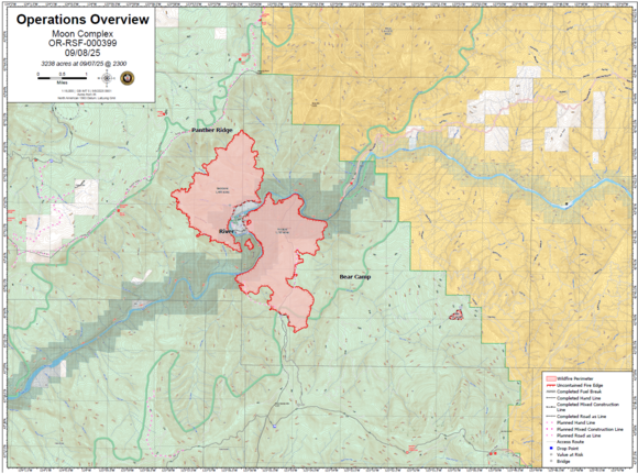
Moon Complex Fire - Rogue River
On September 3, a lightning event on the Rogue River-Siskiyou National Forest caused a number of fires in the vicinity of the Rogue River about 10 miles northeast of Agness, OR. Six of these made up the initial Moon Complex: the Backbone, Brushy, Pinnacle, Tate, Paradise, and Stair fires. As of September 8, the Paradise, Stair, and Brushy fires burned into the perimeters of other fires and will not be reported on separately.
Great Basin Team 5 took command of the incident at 1800 on September 6.
Evacuations: An evacuation order remains in place for the Paradise and Half-Moon Lodge areas. Please see the Curry County Sheriff’s Office website for more information.
Fire Restrictions are in effect: Stage III fire restrictions went into effect on the Wild and Scenic Lower Rogue River on Friday, August 15, 2025. Building, maintaining, attending, or use of a fire is not permitted. To learn more, visit: https://www.fs.usda.gov/r06/rogue-siskiyou/alerts/stage-3-public-use-restrictions-wild-and-scenic-lower-rogue-river
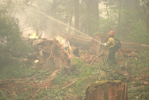
Photo of helicopter work on the Moon Complex. Photo credit: Russel Simmons, Coos Forest Protective Association - Gold Beach AUF.
CLICK HERE for most recent updates.
Emigrant Fire - Umpqua and Willamette National Forest
QUICK LINKS
Daily Update (PDF)
Daily Map (PDF)
Facebook: Emigrant Fire
Smoke: https://www.airnow.gov
Public information: https://linktr.ee/2025.emigrantfire
CURRENT STATUS: Firefighters are facing challenging weather conditions, including heavy rain, hail, and lightning. While the precipitation helped decrease fire behavior, it also introduced new hazards for crews working on the line. These include the potential for new fires from lightning strikes, falling trees caused by strong winds, and slippery terrain, which complicate movement and operations. The fire is expected to receive over an inch of rain, which should aid suppression efforts moving forward. While driving stay alert to fire response teams and their gear, as wet conditions and reduced visibility can increase danger.
Crews are focusing on strengthening containment lines and mop-up operations. This process involves extinguishing any remaining hot spots and smoldering material to prevent re-ignition. Firefighters are chipping, snagging, and removing hazard trees to improve safety and access for personnel and equipment.
Contingency groups, designated fire suppression personnel and equipment, prepared to address incidents that may surpass the capabilities of primary holding resources, remain engaged in prepping secondary containment lines, ensuring that alternative control options are in place should the fire escape primary lines. Heavy equipment task forces are actively building contingency lines to slow potential fire spread and support suppression operations.
Firefighters responded to two spot fires. At the north edge crews effectively lined the spot fire and completed a hose lay, successfully moving the area into mop-up. On the south edge, mop-up is also underway, and crews have been working efficiently to ensure containment of the spot fire.
California Complex Incident Management Team (CIIMT) 3 assumed command of the fire on September 9th, 2025, as of 7:00 am. This is the team’s third deployment serving the Willamette National Forest within the last year. In 2024 CA Team 3 assisted with the North Willamette Complex Fire twice. More information on those previous incidents can be found at https://bit.ly/4gbMUvg.
WEATHER & FIRE BEHAVIOR: Rain and thunderstorms are expected today. Temperatures will be in the 60s with relative humidity being above 40 percent. Temperatures are expected to rise toward the end of the week. Detailed forecast available at https://forecast.weather.gov/ Fire behavior will remain subdued as cooler temperatures, rain, and high humidity prevent rapid fire growth, however heavy fuels will remain smoldering especially in closed canopy timber.
RESTRICTIONS & CLOSURES:
Willamette National Forest closure order for the fire can be found at https://www.fs.usda.gov/r06/willamette/alerts/emigrant-fire-closure-order. Willamette National Forest fire restrictions can be found at https://www.fs.usda.gov/r06/willamette/alerts/temporary-fire-public-use-restrictions-are-effect
Umpqua National Forest closure can be found at https://www.fs.usda.gov/r06/umpqua/alerts/emigrant-fire-closure-order-no-06-15-03-25-02. Umpqua National Forest fire restrictions can be found at https://www.fs.usda.gov/r06/umpqua/alerts/public-use-restrictions-level-2.
SMOKE: Air quality is expected to gradually improve over the next few days as emissions from the Emigrant Fire decrease. In low lying areas, fog may mix with smoke and reduce visibility. Smoke and air quality information is available at https://www.oregonsmoke.org/ and https://www.airnow.gov.
DRONES AND AVIATION SAFETY: The Federal Aviation Administration in conjunction with Fire Management has issued a Notice to Airman (NOTAM) for all aircraft below 11,500’ MSL. For details, please visit: https://tfr.faa.gov/tfr3/?page=detail_5_7025 Wildfires are a no-fly zone for unauthorized aircraft, including drones. If you fly, we can’t. For more information, visit http://knowbeforeyoufly.org.
BACKGROUND: The lightning-caused Emigrant Fire was reported on Aug. 24, 2025. The fire ignited in a remote area 3 miles southwest of Indigo Springs Campground. The fire spread rapidly through the 2009 Tumblebug Fire burn scar, which has many standing and fallen dead trees plus dense brush, and few opportunities for direct control of the fire. Indirect control lines were established around the fire, many along roads or in locations previously used by the Tumblebug Fire. As of early September, the Emigrant Fire has reached some of these control lines, mainly on the northern part of the fire.
The Emigrant Fire is now spreading in areas that were not recently burned. Fire growth has been slower due to greener fuels, but is still active, depending upon the weather.
ABOUT THE FOREST: The Willamette National Forest covers an impressive swath of the Cascade Mountains in Oregon, where volcanic peaks tower above iconic Douglas firs, and crystal-clear waters crash over immense waterfalls. This forest encompasses 1,675,407 acres, and within that landscape, you will find diverse habitats, numerous recreation opportunities, and fascinating history.
At 10,495 feet above sea level, Mt. Jefferson is Oregon’s second-highest peak and the tallest point within the Forest. Six other major Cascade peaks can also be found here, including Three Fingered Jack, Mt. Washington, the Three Sisters, and Diamond Peak.
CLICK HERE for most recent updates.
DFPA Fire Information
𝐃𝐅𝐏𝐀 𝐍𝐄𝐖𝐒 𝐑𝐄𝐋𝐄𝐀𝐒𝐄: 𝟎𝟗/𝟎𝟗/𝟐𝟓 𝐋𝐈𝐆𝐇𝐓𝐍𝐈𝐍𝐆 𝐑𝐄𝐒𝐏𝐎𝐍𝐒𝐄 𝐂𝐎𝐍𝐓𝐈𝐍𝐔𝐄𝐒
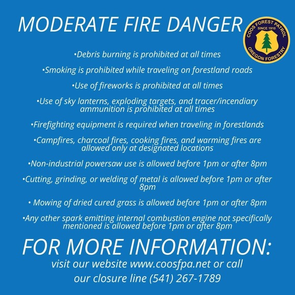
The Douglas Forest Protective Association (DFPA) remains actively involved in lightning reconnaissance and initial attack efforts after frequent lightning activity throughout Monday, September 8, 2025. A total of 280 lightning strikes were recorded, with nine confirmed lightning-caused fires. Five of these fires are in patrol status, while firefighters are engaged on four.
𝐂𝐎𝐍𝐓𝐀𝐈𝐍𝐄𝐃 𝐅𝐈𝐑𝐄𝐒
- Boswell Fire. Yoncalla, ORE: a single lightning-struck tree fire, with a total fire size of 0.01 acres, occurred near the 1100 block of Boswell Road in Yoncalla. This fire is fully extinguished and now in patrol status.
- Little Camp Fire. Elkton, ORE: located 7 miles southwest of Elkton, the 0.04-acre fire is mopped up and in patrol status.
- Shively Fire. Days Creek, ORE: located near the 15800 block of Tiller Trail Highway in Days Creek, the 0.01-acre fire is mopped up and in patrol status.
- Jordan Creek Fire. Canyonville, ORE: located approximately 1 mile southeast of Canyonville, the 0.001-acre fire is mopped up and in patrol status.
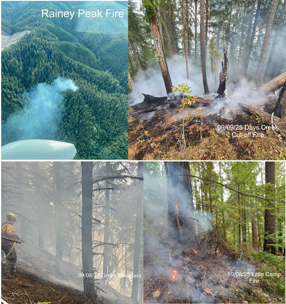
- Days Creek Cut-off Fire. Myrtle Creek, ORE: located approximately 3 miles southeast of Myrtle Creek, near Days Creek Cut-off Road, a 0.2-acre fire is mopped up and in patrol status.
𝐈𝐍 𝐌𝐎𝐏-𝐔𝐏
- Rainy Peak Fire. Elkton, ORE: located 7 miles southwest of Elkton, the total 0.49-acre fire is trailed and in mop-up status.
- East Fork Fire. Milo, ORE: located 2 miles south of Milo, a single lightning-struck tree with minimal ground fire, covering 0.01 acres. Crews are engaged in mop-up.
- Green Mountain Fire. Drain, ORE: located 2.5 miles northeast of Drain, the estimated 0.5-acre fire was found to have heat during this morning’s check. Crews are reengaged in mop-up with this fire.
𝐅𝐈𝐑𝐄 𝐀𝐂𝐓𝐈𝐕𝐈𝐓𝐘
- Homestead Fire. Milo, ORE: located 2 miles south of Milo, crews are currently clearing a trail into the location of a confirmed single lightning-struck tree fire. There is presently minimal fire activity, with limited smoke in the area.
These fires pose no threat to homes or structures.
Precipitation received across the district will moderate fire activity, aiding firefighters in their suppression efforts; however, the heat from air-to-ground lightning strikes can remain in larger fuels for several days, until the first signs of smoke appear. Please report any smoke columns to 9-1-1.
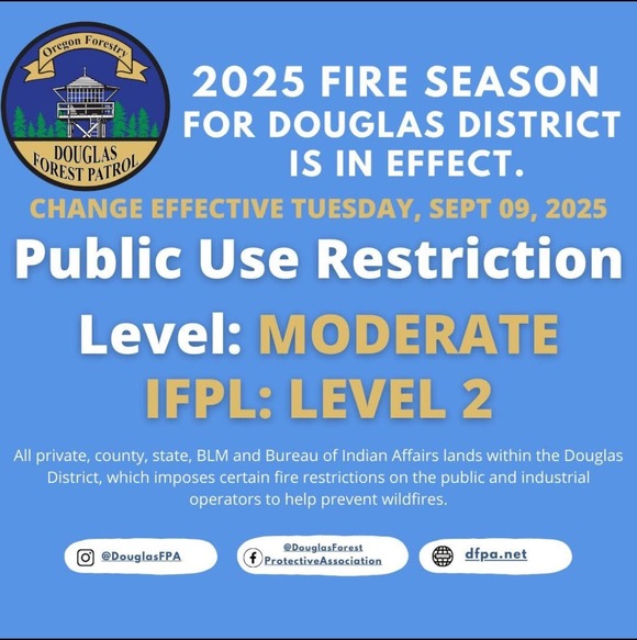
Scattered thunderstorms with a 38% chance of lightning and wetting rain are forecasted for the Umpqua Basin until midnight tonight. Increased precipitation, humidity, and lower temperatures have allowed the fire danger level to decrease to MODERATE, effective today; however, fire danger remains prevalent.
𝐎𝐩𝐞𝐧 𝐟𝐢𝐫𝐞𝐬, 𝐰𝐚𝐫𝐦𝐢𝐧𝐠 𝐟𝐢𝐫𝐞𝐬, 𝐝𝐞𝐛𝐫𝐢𝐬 𝐛𝐮𝐫𝐧𝐢𝐧𝐠, 𝐚𝐧𝐝 𝐭𝐡𝐞 𝐮𝐬𝐞 𝐨𝐟 𝐛𝐮𝐫𝐧 𝐛𝐚𝐫𝐫𝐞𝐥𝐬 𝐫𝐞𝐦𝐚𝐢𝐧 𝐫𝐞𝐬𝐭𝐫𝐢𝐜𝐭𝐞𝐝 𝐝𝐮𝐫𝐢𝐧𝐠 𝐭𝐡𝐞 𝐟𝐢𝐫𝐞 𝐬𝐞𝐚𝐬𝐨𝐧. 𝐏𝐥𝐞𝐚𝐬𝐞 𝐚𝐝𝐡𝐞𝐫𝐞 𝐭𝐨 𝐭𝐡𝐞𝐬𝐞 𝐫𝐞𝐠𝐮𝐥𝐚𝐭𝐢𝐨𝐧𝐬 𝐭𝐨 𝐡𝐞𝐥𝐩 𝐩𝐫𝐞𝐯𝐞𝐧𝐭 𝐡𝐮𝐦𝐚𝐧-𝐜𝐚𝐮𝐬𝐞𝐝 𝐟𝐢𝐫𝐞𝐬.
PHOTO CREDITs: Coos FPA, HHenderson (DFPA), ARoberts (DFPA)
------------------------------------------------------------------
DFPA NEWS RELEASE: Monday Evening Update
DFPA DISTRICT (09/08/25): The Douglas Forest Protective Association (DFPA) has been actively involved in lightning reconnaissance and initial attack following several lightning storms that occurred on September 8, 2025. DFPA has responded to numerous smoke investigations. Of these responses, four have been confirmed fires. Of these four, two are contained.
CONTAINED FIRES
- Green Mountain Fire. Drain, ORE: located 2.5 miles northeast of Drain, Oregon, the estimated 0.33-acre fire is 100% lined, plumbed, and in mop-up status.
- Boswell Fire. Yoncalla, ORE: One single lightning-struck tree fire has been confirmed near the 1100 block of Boswell Road in Yoncalla. This fire is 100% mopped up and in patrol status.
INITIAL ATTACK
DFPA & CFPA (Coos Forest Protective Association) crews are engaged on two lightning-struck trees in a remote area about 7 miles southwest of Elkton, Oregon. Aerial reconnaissance was used to monitor the fires until weather conditions required grounding. For safety reasons, DFPA’s air attack has been grounded until the weather permits.
- Rainy Peak Fire. Elkton, ORE: DFPA & CFPA crews are engaged in initial attack on an estimated 0.50-acre fire.
- Little Camp Fire. Elkton, ORE: DFPA & CFPA crews are engaged in initial attack on an estimated 0.25-acre fire.
Information on these fires is still developing. Updates on their progress will be provided later.
These fires pose no threat to homes or structures.
Scattered thunderstorms with a 24–26% chance of lightning are expected to persist across the area until Tuesday night. Lightning reconnaissance efforts will continue. Please report any smoke columns to 9-1-1.
Cooler weather is expected to continue throughout the week; however, fire danger remains. Please continue to follow public restrictions in place to prevent human-caused fires.
This is just some of the recent fire information from around the district. Again, we are grateful for the work of our firefighters and first responders. Thank you for your dedication and heroic efforts for our residents.
Yours Truly,
 Senator David Brock Smith
Together, We Will Build a Better Oregon
 Senate District 1
Curry, Coos, and Douglas Counties
Southwest Oregon’s Fish, Farm, and Forestry District.
Capitol Phone: 503-986-1701
Capitol Address: 900 Court St. NE, S-316, Salem, Oregon 97301
Email: Sen.DavidBrockSmith@oregonlegislature.gov
Website: http://www.oregonlegislature.gov/smithd
|