 Coos and Douglas Fires – All is well and basically quiet with growth either minimal or stopped.
Curry County – ANVIL FIRE – 22,000 acres – 1,300 Fire Fighters. 16% contained. Basically 4 quiet nights with little winds - humidity up considerable with temps down and good somewhat measurable rains predicted. Reality – Sad news - 85% to 90% of the (17,000 acres) Grassy Knob Wilderness area destroyed. (more on this later…). Oregon and the people we represent know where we stand on this horribly poor Forest Management.
(Thursday had a fire spring up in North Curry near Sixes – Local Fire Fighters and Coos Forest Protective had it out promptly – GREAT JOB AGAIN! The level of rain will reveal in the next couple of days if CFPA will call an end to the 2023 Fires Season – We know the sun will come back out and the Forest Floors could dry again quickly…) We’d like to give a huge shout-out and send gratitude again to our Local Coos, Curry and Douglas Volunteer Fire Departments and too send our Logging Communities a huge note of appreciation. They are often the first ones to the fires. No one cares more about the environment than our Timber Companies and their staffs. (more on this later also…)
From Mike Robison – Director, Coos Forest Protective Association…
To date, Anvil is over 22,000 acres and continues to spread even though we saw a slight amount of rain this morning. Forecasted strong SW winds have arrived and the fire is moving around aided by wind, slope, and dry fuels. The critical areas include Moon Mountain and Avery Mountain. Personnel and aircraft continue to try and check the fire movement as the fire crosses drainages and aligns on steep slopes to make runs from the creeks to the ridges. With hard work, we have established an anchor on a portion of the fire that protects BLM, Campbell, and Tribal lands. The effort today is to maintain these lines through the wind event that is currently in progress across the fire.
We have the potential to lose more ground today as the frontal wind blows prior to any significant rain arriving (if it arrives at all). We have suppressed two fires on the north side of Sixes in the last several days. Most recently a fire was spotted this morning and crews are working now to contain it at 1 acre in size. Several days ago, we suppressed a fire in logging slash at 2.5 acres in the same area. We think that both are individual fires and not related to the Anvil fire.
I will report out on the status of the fire after this weather event is over. Have a great day. Mike Robison
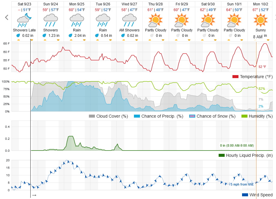
Nothing beats the Lee Riddle Research – see below. (thanks Lee)…
FIRE UPDATES 9-23-23 RAIN, WEATHER, ANVIL and Smith River Complex -
Storms Through Tuesday Could Force the Closure of 199 Again
“A storm is expected to bring a significant amount of rainfall to Del Norte County this weekend, and we might have to close U.S. 199 if we are unable to keep the roadway in a safe condition for motorists,” they posted late this afternoon. “If you don’t have to travel Sunday or Monday on U.S. 199, please stay home and be safe.” https://kymkemp.com/2023/09/21/storms-coming-this-weekend-could-force-the-closure-of-199-again/
BROOKINGS AREA FORECAST (this keeps changing)
Update it here: https://www.wunderground.com/forecast/us/or/brookings?cm_ven=localwx_10day
 ANVIL FIRE UPDATES
9/23 Anvil Fire Update
Size: 20,657 acres | Start Date: August 25, 2023 | Location: 8 miles east of Port Orford, OR | Containment: 9% | Total personnel: 1,321 | Resources: 37 crews, 8 helicopters, 47 engines
Fire managers and crews are preparing for the weekend’s forecast precipitation. More than 1,300 people are now assigned to the fire, allowing fire managers to deploy resources on the Anvil Fire’s multiple active fronts. Dozers and hand crews have been working continuously to construct line around pockets of fire south of Elk River between Sunshine Bar and Butler Bar campgrounds. The Coos Forest Protective Association and other crews successfully pushed back on the fire as it approached containment line above the North Fork of Dry Creek. Bucket drops once again made a big difference in supporting ground crews, drenching flames with more than 172,000 gallons of water. Unmanned aerial systems (UAS) patrolled the Anvil Fire area overnight, greeting the day shift with real-time information about embers outside the main fire or trouble areas to prioritize. Today’s milder weather will provide firefighters an opportunity to shore up and extend containment lines that are likely to be tested later this weekend.
There is a high probability for rain Sunday evening, but fire managers are preparing for potential high winds that may arrive prior to the much-needed moisture. The Anvil Base Camp is near Cape Blanco State Park north of Port Orford off US Highway 101. Many of the crews and equipment assigned to the fire are operating out of this camp. Please drive slowly with your headlights on in this congested area.
 SMITH RIVER COMPLEX
NORTH Daily operations update for September 23nd, 2023 VIDEO
https://www.facebook.com/watch/?v=333413675826045
Smith River Complex North Update Saturday, September 23, 2023
Size: 94,508 acres (12,460 ac. in Oregon); Location: Grants Pass, OR; Cause: Lightning Containment: 84%; Start date: August 15, 2023; Total personnel: 1,394 Resources: 31 crews 6 helicopters 37 engines 8 dozers 29 water tenders 6 masticators 1 Skid Steer
Yesterday: The operational focus shifted to fire suppression repair along with continued ground and aerial backhaul operations. Firefighters began preparing to manage for possible impacts from significant amounts of rain on the efforts to complete the secondary control line along the FS 1106 road.
Today’s Activities: Operational focus remains on fire suppression repair and equipment backhauling operations. Weather models suggest the possibility of significant rainfall on Sunday night, Monday and into Tuesday. Dry forest fuels may have less chance of ignition this weekend due to forecasted heavy rains. Possible debris flows and flooding with increased rain and winds may occur. One helicopter will remain assigned to the Smith River Complex North this weekend while others are reassigned to other parts of the fire area. Fire personnel assigned to the fire will be downsizing this weekend into early next week as suppression objectives are completed.
Smith River Complex-South Zone Morning Operational Briefing 9/23/2023 VIDEO
https://www.facebook.com/watch/?v=1481023615990181
Smith River Complex South Update September 23, 2023
Combined Acreage: 94,508 acres Containment: 84% Personnel: 1,394
CURRENT SITUATION: Friday’s calmer weather helped to minimize fire behavior. Crews continued to patrol containment lines of the main fire and US 199 while also mending any damage to the forest caused by firefighting operations. Crews monitored the fire on the east side, where it is burning in the Siskiyou Wilderness. Helicopters conducted water drops to reduce the fire’s intensity and slow its southward progression toward the Bear Basin Lookout. There has been no significant activity on the Hurdy Gurdy. Crews continuously monitor the northwest portion as it smolders and creeps towards the main fire. Today resource’s will construct direct line using MIST (minimal impact suppression tactics) where appropriate and indirect line from 17N035 (H26) to Hurdy Gurdy Creek. Predicted flood watch Sunday afternoon through Monday Evening is forecasted. Fire management officers are evaluating and planning to ensure the safety of firefighter crews and minimize damage to the forest. Some of the key safety measures are to remove heavy equipment from the burn area to pavement, this step helps prevent potential damage to the forest. They will also be deploying firefighting crews strategically in tactical locations allowing them to engage with the fire when conditions permit, enabling efficient firefighting efforts. Importantly, it also ensures that they can retreat to safety if conditions worsen or become hazardous. Safety is always a top priority.
WEATHER: ***FLOOD WATCH SUNDAY AFTERNOON THROUGH MONDAY EVENING*** A weak weather system will move in off of the Pacific today with clouds increasing and a chance of sprinkles this afternoon and evening. Valley temperatures 60-65°, Ridgetops 56-60°, Valley relative humidity 44-52%, Ridgetops 52-60%. Increased onshore flow with cloud cover will result in cooler temperatures and higher humidity. Ridgetop winds will be out of the west-southwest 4-7 mph in the morning increasing to 8-12 mph in the afternoon.
Capitol Phone: 503-986-1401
Capitol Address: 900 Court St. NE, H-382, Salem, Oregon 97301
Email: Rep.CourtBoice@oregonlegislature.gov
Website: https://www.oregonlegislature.gov/boice
|