 Good Day –
Coos County – No Fires
Douglas County – 3 Fires – 0 Active (Tyee Ridge Complex – Day 27) – Mop up category – has not grown in acreage for several days (7,900) Oregon Department of Forestry has turned full Management over to the Douglas Forest Protective Association and is 90% contained.
Curry County – 3 Fires – 2 Active (Anvil – Day 27) – Port Orford is the home of Senator David Brock Smith and his parents. North Curry is my roots and of course we all have many friends there. As of this morning the Anvil Fire is the Number One Priority Fire in the U.S. That will improve odds in helping with additional resources – requests and in competing with other National Fires. It does not mean necessarily that the Anvil is the highest level of risk to Public Safety, although our City of Port Orford is a huge concern. Curry County has very detailed plans in order to meet any possible daily scenarios.
The Oregon Department of Forestry, U.S. Forest Service, Curry Volunteer Fire Departments, Oregon State Fire Marshal and Coos Forest Protective are constantly placing more Fire Fighters in the best possible positions – now up to almost 800 -- By the time you read this report – the lost acreage will likely be nudging up to at least 10,000 as the Anvil has grown in it’s 27 days about 400 average acres. We’re having daily cooperators meetings at 10:00 am and last evening, the second Port Orford Community Meeting just completed with another excellent turnout.
(Smith River Complex – Day 36)- (see below) – 65% contained – 1,450 Fighters – Acres - 92,180 total (12,460 in Oregon)
(Curry Flat Fire – Day 82) Still no growth – 75% contained – 75 Fighters – 32,000 Acres
OF COURSE EVERYTHING ON ALL THESE FIRES IS WEATHER AND FIRE CONDITIONAL
PLEASE REMIND EVERYONE YOU KNOW – NO NEW FIRES – BE ON GUARD FOR ANY FIRE SOURCE – ANYTHING COMBUSTIBLE YOU’RE NEAR
 A community meeting was held last night at 7 PM at the Sixes Grange Hall and broadcasted live on Facebook. Fire managers and local agency representatives shared information and answered questions about the fires.
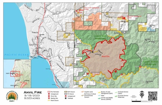
Anvil Fire
Size: 9,023 acres
Start Date: August 25, 2023
Location: 8 miles east of Port Orford, OR
Containment: 0%
Total personnel: 779
Resources: 19 crews, 4 helicopters, 32 engines
The strategic preparations firefighters have made to protect structures and keep the Anvil Fire within containment lines resulted in minimal fire growth Monday. To counter critical fire weather conditions, crews maintained a heavy presence of engines, mechanized equipment, helicopters, and hand crews. Patrols from the air and ground scoured the area for signs of fire embers drifting over the Elk River Road but detected none. Additional work has been completed near the Fish Hatchery to burn vegetation from the pre-constructed containment line down the ridge to reduce the intensity of the main fire as it approaches the ridge. Firefighters are evaluating the effectiveness of these actions constantly as the wind direction and weather conditions change. Mechanical issues prevented infrared mapping last night so exact acreage has not been updated.
Yesterday, firefighters were successful in slowing fire spread in spite of windy and dry conditions. More challenging weather is in the forecast for today and tonight. In response, managers bolstered night shift operations in the Elk River corridor and have ordered more firefighters.
Fire managers and local agency representatives are hosting a community meeting tonight at 7 PM at the Sixes Grange. Community members are invited to bring questions in person or live on Facebook: http://facebook.com/flatfireoregon2023.
Evacuations: Curry County Sheriff’s Office has identified four evacuation zones around the Anvil Fire. An interactive evacuation map is available at https://bit.ly/45UIh2E. Zones 1 and 4 are in Level 3 “Go“ evacuation status. Zones 2 and 3 are in Level 2 “Get Set“ status. Sign up for Curry Co. emergency alerts at https://bit.ly/CurryCoEM.
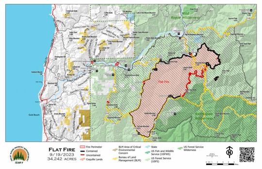
Flat Fire
Size: 34,242 acres
Start Date: July 15, 2023
Location: 2 miles southeast of Agness, OR
Containment: 75%
Total personnel: 78
Resources: 1 crews, 3 helicopters, 1 engines
The Flat Fire has remained mostly static, but fire engines continue to patrol and monitor the fire and respond rapidly as needed to any increased fire behavior. On Monday, crews worked to extinguish fire from a stump hole within the existing containment line. Repair of suppression line is ongoing. The fire camp located at Old Mill will be closed up this morning as it is no longer needed to support the resources still assigned to the Flat Fire.
General Information
Weather: A Red Flag Warning, an indication of weather conditions that could contribute to large fire growth, is in effect in the fire area from Monday at midnight through Tuesday at noon. Ridgetop winds are expected to top 25 mph. Relative humidity will also be low during this time. North/northeast winds are forecast for tonight. Fire managers are coordinating with local agencies to prepare for these weather events and their impact to the fires. Conditions may change quickly. Continue to monitor information sites for fire status updates.
Smoke: Visit https://bit.ly/SWORsmoke for current smoke and air quality updates.
Area and Road Closures: For the safety of firefighters and the public, the Rogue River-Siskiyou National Forest has issued closure orders for the Anvil and Flat Fire areas. The Bureau of Land Management Coos Bay District has also issued an area closure which includes Edson and Sixes Campgrounds. Visit https://inciweb.wildfire.gov/incident-closures/orrsf-anvil-fire and https://inciweb.wildfire.gov/incident-closures/xx1002-flat-fire for closure maps and information.
Smoke and the marine cloud layer are mingling and settling in the lower elevations overnight causing limited visibility along highways. Please drive slowly and with headlights on through any fire area. Heavy equipment and firefighter transportation vehicles are also using the area highways and roads. Caltrans issued a schedule of road closures and lane restrictions on US-199 northeast from Crescent City. Local law enforcement cautions against any non-essential traffic along this route. For specific information on road access, please see the Caltrans QuickMap site at: https://quickmap.dot.ca.gov/ and Oregon Department of Transportation site at: https://www.tripcheck.com/. Do not use forest roads for alternate routes.
Size: 92,180 total/ 12,460 in Oregon
Start Date: August 15, 2023
Location: Grants Pass, OR
Containment: 65%
Total personnel: 1,473 for Complex
Cause: Lightning
Resources: 37 crews 11 helicopters 66 engines 8 bulldozers 26 water tenders 14 masticators 1 Skid Steer
Yesterday: Containment line was increased on the northern edge of the fire to bring containment to 65%. Fire managers are confident the fire will not cross that line, even when challenged by changing weather conditions. Minimal fire activity remains in the interior of the fire area. Crews cleaned up pockets of unburned vegetation on the northwest edge of the fire. Fire activity increased slightly in the powerline corridor and containment lines held.
Today’s Activities: Crews will continue to monitor, mop up, and secure control of the north and northwest portions of the fire boundary and continue to protect the powerline corridor along the 316 road. On the east side of the fire, crews are removing hose, temporary water tanks, and other fire suppression infrastructure around private property, since fire spread is no longer a risk in that area.
Smoke: Expect decreasing smoke throughout the area today with reduced local fire activity. GOOD air quality in Grants Pass, Medford, and Ashland; O'Brien and Cave Junction will experience smoke impacts through afternoon. Smoke levels can change rapidly depending on weather; check current conditions at: https://bit.ly/SWORsmoke
Closures: The Rogue River-Siskiyou National Forest issued an area and road closure for a 400-yard-wide corridor centered on Forest Road 1106 (South Elk Mountain Road), Forest Road 1205 (Lower Wheeler Road), and Forest Road 1983 (Mt. Emily Road) beginning yesterday, September 14 through October 31, 2023. The closure allows for safe operations related to the Smith River Complex North. Closures on BLM land are in place, as well. Visit bit.ly/RRSNFAlerts or https://www.blm.gov/orwafire for additional information.
Road Closures and Delays: Caltrans in Del Norte County issued a schedule of road closures and lane restrictions on US-199. Weekdays will have a combination of road closure and lane restrictions. Over the weekend, the road will remain open, but with lane restrictions and pilot cars. Expect delays. For specific information on road access, please see the Caltrans QuickMap site https://quickmap.dot.ca.gov/ and Oregon Department of Transportation’s https://www.tripcheck.com/. Local law enforcement cautions against any non-essential traffic along this route. Navigation apps and mapping programs have been routing travelers into active fire areas. Do not use forest roads as alternate routes.
Evacuations: Monitor the Rogue Valley Emergency Management site and sign up for evacuation alerts and updates at https://rvem.org/. An interactive Fire First Response Map with evacuation areas can also be found there.
Restrictions: Please respect the temporary flight restriction (TFR) established for the Smith River Complex. Keep drones away from firefighting operations and the TFR. If you fly, we can’t. Don’t be the reason a firefighting air mission has to divert! For more information on the TFR, visit https://tfr.faa.gov/.
Capitol Phone: 503-986-1401
Capitol Address: 900 Court St. NE, H-382, Salem, Oregon 97301
Email: Rep.CourtBoice@oregonlegislature.gov
Website: https://www.oregonlegislature.gov/boice
|