
Hello Friends,
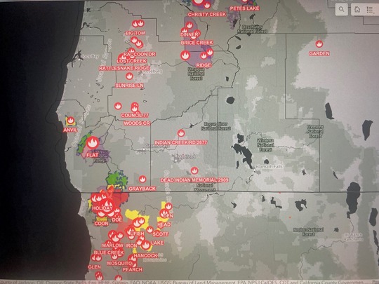
Northern California - Smith River Complex – 85,000 acres now and about 7,000 of those are in Oregon. ($ 35 Million cost to date…) very, very sorry to report - 12 California structures lost. Governor Kotek called a Conflagration Declaration which brings in the Oregon State Fire Marshal – Incident Management Blue Team for additional structure protection for Southern Josephine County. Oregon has 48 Active Fires and has lost 106,000 acres to date.
Douglas County - Tyee Ridge Complex (Cougar) –. Now about 6,000 Acres – Next 48 hours ‘likely’ to bring good news. Originally 16 fires in Douglas County – beginning on the morning of August 25th – many are controlled or out! Still close to a dozen – although a few have grown together – Oregon Department of Forestry is protecting Douglas Fire Protective Association – District 2 – All Fire Teams – No question are doing an EXCEPTIONAL JOB!
Coos County – 0 Fires
Curry County – 2 to 3 fires
I was born in Gold Beach and have lived here my entire life. Yes – we’ve just received some reasonably good and welcome rain – good news for sure, however – that could mean that we’ll have a late drier than normal fall. The old timers here have witnessed that many times over the years - So we’re likely at least a full month yet before Fire Season is over;
KEEP OREGON GREEN – BE ON CAREFUL GUARD FOR THE SLIGHTEST ‘MAN MADE’ FIRES. IF WE ALL DO OUR PART – ODDS ARE WE CAN ENJOY THE REST OF THE SUMMER.
Start date: Aug 15, 2023
Location: Wild Rivers Ranger District
Cause: Lightning
Acres: 79,053
Containment: 7 percent
Personnel: 3,053 for Complex
GRANTS PASS, Ore. – Firefighters continue to make steady progress establishing fire lines to protect the communities of the Illinois Valley and halt the spread of the Smith River Complex North.
“We are working aggressively to fully suppress this fire,” said Scott Blower, Wild River District Ranger for the Rogue River-Siskiyou National Forest.
With aviation support and favorable winds, tactical firing operations are occurring during both day and night shift. Tactical firing is strategic ignition by a team of fire experts under controlled conditions to bring the fire perimeter to a predetermined containment feature. It stops the forward progression of a wildfire while consuming ground litter and dried vegetation. Shrubs and trees are generally left intact.
Oregon State Fire Marshal (OSFM) task forces continue to expand defensible space around threatened structures, protecting them from any firebrands or embers. Firebrands are small pieces of burning vegetation such as small branches or leaves that can be carried across a fire line by the wind. After dark, OSFM crews are conducting perimeter patrols, watching for spot fires and assisting wildland resources as needed.
Winds out of the northeast have been pushing the fire back on itself the past several days but are expected to shift again this weekend and come from the southwest. Cooler weather and measurable rain are also predicted this weekend, which may reduce fire activity, but will not be sufficient to extinguish the fire.
A Level 3 – GO NOW evacuation remains in place for the Hwy 199 area south of O’Brien from milepost 38 to the state line.
A Level 2 – GET SET evacuation is in place for O’Brien and the Takilma area.
A Level 1 – GET READY evacuation is in place north to Cave Junction. An American Red Cross evacuation shelter is located at Rogue Community College in Grants Pass. Livestock can be sheltered at the Josephine County Fairgrounds.
Due to fire activity, the public is encouraged to monitor the Rogue Valley Emergency Management site at the link below for evacuation updates. An interactive Fire First Response Map showing evacuation areas can also be found there.
Rogue River-Siskiyou National Forest has implemented an area and road closure order for the Smith River Complex. Visit the forest website for additional information at the link below. The Bureau of Land Management Coos Bay District announced an emergency closure of public lands near the Oregon/California border.
Size: 34,242 acres
Start Date: July 15, 2023
Point of origin: 2 miles southeast of Agness, OR
Containment: 58%
Total personnel: 330
Resources: 5 crews l 3 helicopters l 8 engines l 3 bulldozers l 9 water tenders l 4 masticators
The Northern Rockies Incident Management Team - Team 3 will assume command of the Flat and Anvil Fires as of 7:00 am, Friday September 1, 2023, from the Southwest Area Incident Management Team 3 (SWAIMT-T3). The SWAIMT-T3 provided command for the resources assigned for 14 days while coordinating with county, city and various other agencies including the Rogue River-Siskiyou National Forest.
Fire Activity: Crews and aircraft continue to patrol and monitor the fire’s edge, complete trail repair work and work with private landowners on any repairs needed due to suppression activities. Chipping of fuels continues along Forest Road 109 and will be completed over the weekend. The fire has not grown, but smoke will be visible as interiors fuels consume. Initial Attack resources are staged and ready to assist the forest if needed.
Size: 51 acres
Point of origin: 8 miles east of Port Orford, OR
Containment: 0%
Start Date: August 25, 2023
Total personnel: 97
Resources: 3 crews l 6 helicopters l 12 rappellers l 3 engine l 1 bulldozer
Fire Activity: The Anvil Fire was active yesterday with growth to the west as the fire moved up into drainages on Anvil Mountain. Aircraft used water and retardant along ridges to slow its progression and assist firefighters on the ground. Smoke was very visible yesterday and will continue today, however weather conditions will be changing and higher humidity, lower temperatures and the possibility of moisture will slow the fires progression. The fire is burning in the Grassy Knob Wilderness on steep slopes and difficult terrain with limited access. Aircraft will continue to support fire suppression work and monitor activity.
Weather: Below normal temperatures and higher humidity is expected on Thursday along with increased chances of rain. Showers will linger in the area Friday and Saturday, although rain chances over the Anvil will be more limited. Humidity will remain elevated through the weekend.
Smoke: Smoke lingering within the area is moving north from the Smith River Complex and settling within some nearby communities, like Brookings. The smoke outlook for the Smith River Complex is available at the link below.
Closures: U.S. Highway 199 has been closed north of Gasquet due to fires on the Six River National Forest, please use U.S. Route 101 to SR 42 for all travel to and from the Rogue Valley. Forest Service and BLM roads should not be used as alternate routes due to emerging fire activity. The Rogue River-Siskiyou National Forest (RRSNF) has issued a closure order for the fire area including trails, roads, and a portion of the Illinois River. More information available at the link below.
Evacuations: As a reminder, be aware of danger in the area. Stay informed: Sign up for emergency alerts with your county. Check the county emergency management website and follow local emergency services on social media for updates (county, sheriff’s office, fire agencies). Level 1 “Get Ready” evacuation status in place for areas in the vicinity of the Flat Fire. More information available at the link below.
Restrictions: Fire danger is currently extreme; the RRSNF is implementing Level 3 Public Use Restrictions (PUR). Level 3 PURs on the Wild Section of the Rogue River have been implemented by the RRSF, Medford BLM and ODF. More information available at the link below.
8.31.23 News Release
Medford, Ore – Lower temperatures and an influx of moisture has moderated fire behavior across the forest. Fire crews and aerial resources have been able to complete mop up and reach containment on many of the fires burning on the Rogue River-Siskiyou National Forest. This will be the last daily update for these fires unless there is a significant change.
The Grayback Fire has line around 100% of the perimeter and is 90% mopped up. There has been no growth or change in fire size. Crews will finish work on this fire and monitor for pockets of interior heat for the next few shifts. There will be no further updates on the Grayback Fire unless significant change occurs.
The Cedar Fire is 100% lined as well and mop up is nearly complete. This incident will be monitored by ground and air to ensure there are no changes. This will be the last update for the Cedar Fire unless there is significant change.
Capitol Phone: 503-986-1401
Capitol Address: 900 Court St. NE, H-382, Salem, Oregon 97301
Email: Rep.CourtBoice@oregonlegislature.gov
Website: https://www.oregonlegislature.gov/boice
|