
Hello Friends,
I attended the Douglas County Fire Townhall in Roseburg Monday evening – about 140 people of course concerned with several fires that started with the Thursday Night Lightning Strikes.
Tyee Complex Fire - Excellent, well organized and very informative – With 147 structures threatened – some level 3 Evacuations ‘Go Now’ were required. As of this writing total acres lost stands at around 3,200 and overall is 5% contained. 700 personnel - 12 Helicopters. Due to the population centers in Douglas County – the TRC is listed as the top priority fire in Oregon.
Commissioner Freeman was recognized for his 14 years of dedication to Catastrophic Fire Prevention and always quest to improve Federal, State and Local Forest Management.
Reports by:
- Douglas County Sheriff
- Oregon State Fire Marshal
- Oregon Department of Forestry
- Douglas County Commissioner Tim Freeman
- Bureau of Land Management
- State Rep. Virgle Osborne
- Douglas Forest Protective
- Douglas County Rural Fire Departments
What follows is a day or so late – however when Larson and Robison report – it really gets my attention – they are the very best working on Fire Suppression found anywhere.
Good afternoon,
It’s been a busy couple of days for me and I have finally got a break to put out an update. The lightening event we had late Thursday night into Friday morning kept firefighters extremely busy across the entire west side of Oregon. For Southwest Oregon we had a few fires challenge us. Whiskey Creek (30 ac) and Thunder Ranch (16.9 ac) were the two fires of most concern. We do have hand lines and hoses around both fires, and we are currently working on holding these fires where they are. Steep slopes and rollout of burning material remains a concern and we will continue to snag and reinforce the lines thorough the day. Fires will be staffed at night to ensure we don’t lose any ground. All other fires are contained and in patrol status.
ODF continues to be engaged on the Smith River Complex with PNW-13 down in the Selma area (See Deputy AA report below). Afternoon weather conditions have been challenging for Division (I) were the ODF resources are engaged. Looking to improve dozer line between the 4401 road down to HWY 199 and support firing operations. Daily cooperators meetings are occurring every day at 11:00 (link below) for those cooperators who would like more detailed information. ODF Brandon Ferguson is currently serving as Deputy AA.
I really appreciate the dedication of all the firefighters to suppressing these challenging fires and the support that our partners and cooperators are providing us. Looking at a weather pattern change around Tuesday with possible precipitation chances by end of the week.
Thank you,
Dave Larson
Area Director-Southern Oregon Area
Oregon Department of Forestry
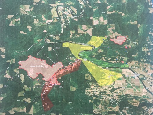 Tyee Ridge Complex, Douglas County
Brandon Ferguson – Oregon Department of Forestry –
The Smith River Complex – North, Community Meeting was held publicly at the Illinois Valley high school from 6-8 p.m. yesterday evening. The meeting was well attended by approximately 200 local residents from surrounding communities. PNW Team 13, Agency Administrators, and local cooperators briefed community member on the fire situation, progress to date, and planning for moving forward in the coming days. The meeting can be viewed at Smith River Complex - North - Community Meeting 08/28/2023. Today should allow some increased relief and paint a clearer picture of the fire situation on the Smith River Complex - North. Northerly winds mid-morning and early afternoon have allowed resources across the fire landscape to see deeper beyond control lines, and aerial resources have been able to scout a much greater footprint of the fire. A spot fire was found yesterday evening, and quickly mitigated, approximately ¾ of a mile North of the active fire. Firing operations were initiated along the 461 Rd. to the Northwest to corral the fire away from the O’Brien community. Team 13 is at a pinch point with Private, BLM, and USFS Protected lands at the confluence of Rock Creek and Elk Creek drainages. Conflagration was enacted yesterday, and OSFM Blue Team – IC Kuntz is working in unified command with Team 13 as of 0800 this morning. I’m feeling much more comfortable with what we have in place, and the increased capacity will significantly increase the opportunity for success for public safety and meeting incident objectives. Winds shifting to the Northerly and strengthening today through Thursday will show what the progress needs will be moving forward. There are some bolded information at the end for timelines of teams and transitions, and the public meeting this evening. Our Contingency Group continues to excel, and are continuing further North adjacent/along our protection lands, and aiding the structure protection efforts. I have heard consistently, nothing but great feedback from the Team and our coordinating partners.
Tuesday, August 29th Daily Update – Smith River Complex - North
ODF resources continue to support the Smith River Complex – North, Illinois Valley area “Contingency West” and “I” Divisions on Tuesday, August 29th. Last night brought strong SW winds yielding 1 spot fire within contingency lines ¾ miles ahead of the active fire. Firing operations were carried out by IHC burn resources into the early morning along the 461 Road to continue fire progression to the NW away from the O’Brien community. Primary indirect lines have become more direct and remain effective. Winds became N/NW today and will likely lessen complexity to structure protection. OSFM Blue Team is now in Unified Command with PNW IMT 13, and will strengthen structure protection for the O’Brien and surrounding communities. The Team objectives remain to create new and strengthen existing fire lines, roads, and develop additional holding features along the West and Northwest of the O’Brien area. The previous days large spot fire, located North of the two heads of the fire moved East and North East towards burn operations along the East flank through yesterday and overnight. Night firing operations continued North and currently have halted midway along the 461 Road and are anticipated to resume with favorable wind conditions today. Additional contingency lines are being evaluated and implemented Northwest of O’Brien through Private, USFS and BLM protected lands. Team 13 continues coordinating line prep and firing operations in DIV I, through adjacent USFS lands. The ODF Contingency Group remains on the fire with 6 ODF overhead, 9 bulldozers, two masticators, 1 excavator, three UTV’s, two falling modules, and one 20-person Grayback hand crew. Resources are on contract with ODF, are local resources, and familiar with local conditions and terrain. This group will remain on the Smith Complex until the threat to communities and private lands in the Illinois Valley has passed.
Weather will be moderately cooler today than observed yesterday with temperatures remaining in the mid-high 70s and RH lows 37-45% (Up 2-3%). A wind shift from SE to Northwesterly this morning as a high cold front passes over the fire. Average daytime winds will be NW 3-8 and a significant increase in speed (9-13 mph and gusts to 23 mph) is expected tonight. Winds will continually increase in strength from the North Wednesday and Thursday, 10-15 mph average winds (20-30 mph gusts) which should be favorable to existing control lines, but could increase fire activity for available fuels. There is a cooling trend and precipitation anticipated into next weekend September 2nd and 3rd, which should offer some opportunities. There are currently no black lines in place for control lines on the map for Oregon. ODF protected lands burned increased slightly due to firing operations along the NE corner of the fire, and acres burned is approximately 722 acres. Resources are coordinating with DIV I/H for complimenting efforts for holding control lines West and Northwest of the O’Brien community. Oregon BLM acres burned have increase with burn operations to 656 acres. No additional known structures have burned on the Oregon side of the fire, and the OSFM Blue team is now engaged for structure protection throughout the level 3, and level 2 evacuation areas. There is still moderate fire behavior observed and greater visibility today will restore opportunities for air resources engagement on the North side of the fire. A window of opportunity for aerial resources is anticipated today from 1200-1800 when NW and NE winds occur.
Smith River Complex – North (PNW Team 13) commanding the Northern Branch and any fire advancements into Oregon.
Team 13 is planning to build Northern contingency lines near and along the Oregon/California border towards the West and near Brookings.
The current long-term plan is for Smith River Complex-North managing the entire North Branch of the fire including any progression towards the Brookings, Oregon area and CFPA.
USFS has requested a 2-7 day extension for Team 13 due to weather and complexity concerns, to remain in command through as late as Sunday 09/07/2023. (Corrected)
Smith River Complex – South PNW Team 15 is timing out, and SW Team 2 (Corrected) will arrive Today August 29th for inbrief at 1400. SW Team 2 will assume command at 0700 Thursday, August 31st.
Thanks,
Brandon Ferguson, Forest Resources Manager, Oregon Department of Forestry
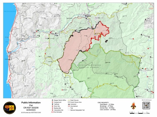
Flat Fire Morning Update
Size: 34,242 acres
Start Date: July 15, 2023
Point of origin: 2 miles southeast of Agness, OR
Containment: 58%
Total personnel: 381
Resources: 11 crews l 3 helicopters l 17 engines l 3 bulldozers l 16 water tenders l 4 masticators
Today’s Activities: The fire remains within its footprint giving crews the ability to make meaningful progress with suppression efforts. Ongoing repair work, including by Oak Flats campground, roads, and trails helps stabilize the area after suppression work and minimizes the fire’s impact to natural resources. Ground resources along with aerial support continue patrolling and monitoring. On Sunday, crews discovered some heat on the south side of the fire and quickly suppressed those areas. An Initial Attack (IA) group consisting of several Flat Fire resources continue to support the local unit on the Cedar fire located north of the Flat Fire.
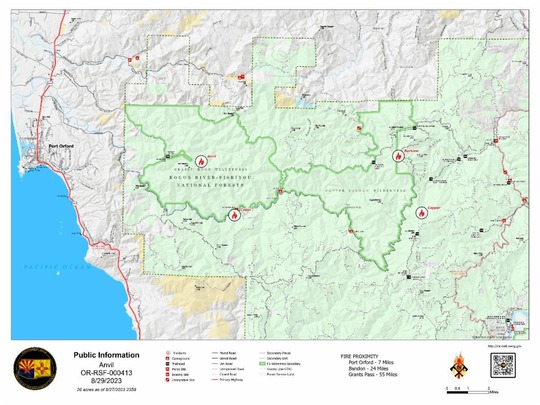
Anvil Fire Morning Update
Size: 25.6 acres
Point of origin: 8 miles east of Port Orford, OR
Containment: 0%
Start Date: August 25, 2023
Total personnel: 52
Resources: 2 crews l 2 helicopters l 12 rappellers l 1 engine l 1 bulldozer
Today’s Activities: Good progress continues to be made on the Anvil Fire as ground crews and aircraft work in tandem to move toward full suppression. The fire is located in steep, and in some areas, inaccessible terrain making access difficult by ground. CFPA provided support with their local dozer early Saturday to clear an old roadbed outside of the wilderness boundary, gaining an additional 1.25 miles of drivable access to deliver crews and supplies cutting the hike in half. Working with the 12 rappellers on scene, resources were able to complete line around the fire by end of shift last night. Aircraft continue to support the incident, but low visibility has limited work at times during the operational periods. No dozer work will be conducted within the wilderness. On Monday, crews assessed retardant line, focused on securing fire edge, and mopped up. Additional resources, including hand crews and masticators arrived on the fire Monday. The fire, located within the Grassy Knob Wilderness is burning in old growth timber approximately 23 miles northwest of the Flat Fire.
Weather: Milder weather over the next few days should help keep fire activity to a minimum due to cooler temperatures and increased humidity levels. A dry cold front will bring slightly cooler temperatures Monday and Tuesday along with a slight increase in northwest winds.
Smoke: Smoke lingering within the area is moving north from the Smith River Complex and settling within some nearby communities, like Brookings. The smoke outlook for the Smith River Complex is available at the link below.
Closures: U.S. Highway 199 has been closed north of Gasquet due to fires on the Six River National Forest, please use U.S. Route 101 to SR 42 for all travel to and from the Rogue Valley. Forest Service and BLM roads should not be used as alternate routes due to emerging fire activity. The Rogue River-Siskiyou National Forest (RRSNF) has issued a closure order for the fire area including trails, roads, and a portion of the Illinois River. More information available at the link below.
Evacuations: Level 1 “Get Ready” evacuation status in place for areas in the vicinity of the Flat Fire. More information available at the link below.
Restrictions: Fire danger is currently extreme; the RRSNF is implementing Level 3 Public Use Restrictions (PUR). Level 3 PURs on the Wild Section of the Rogue River have been implemented by the RRSF, Medford BLM and ODF. More information available at the link below.
Capitol Phone: 503-986-1401
Capitol Address: 900 Court St. NE, H-382, Salem, Oregon 97301
Email: Rep.CourtBoice@oregonlegislature.gov
Website: https://www.oregonlegislature.gov/boice
|