Wow! Lot’s to report on this not so quiet Sunday Morning. Two excellent reports from our good friend Mike Robison yesterday morning and then again last night.
Throughout the Western U.S.; Needless to say – there is tremendous pressure on all of our Fire Fighting Teams.
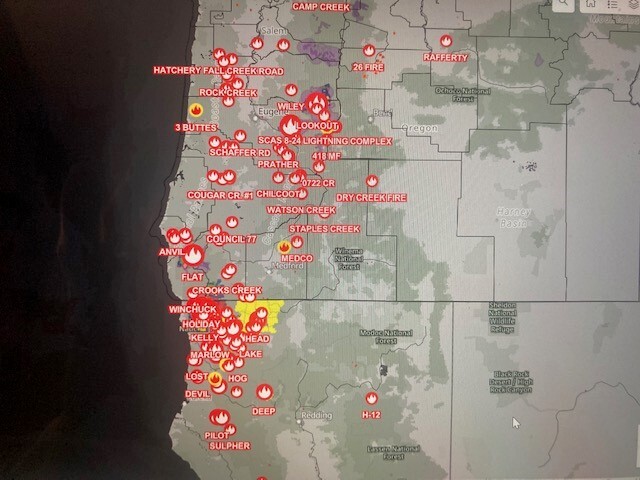
This email and attachments have considerable info. for you. The first – a visual of all the fires is sobering. I have to travel to Salem early tomorrow morning, so may not have the next report for you until Tuesday the 29th. Stay safe everyone…
Reminding everyone- (None of us are exempt..) We need to be HYPER AWARE OF ALL AND ANY NEW FIRE DANGERS. Keep Oregon Green – No additional Fires.
Coos County – 1 Fire …
Curry County – 5 Fires …
Douglas County – 13 Fires …
Josephine – 6 Fires …
Jackson County 3 Fires …
From Mike Robison – Director Coos Forest Protective Association - (7:30 AM – Saturday, 8-26-23)
As most everyone knows, CFPA along with all Western Oregon experienced a significant lightning event Thursday evening into Friday morning. Some rain came with this storm, but not everywhere and not in very large amounts (less than .20”). Yesterday saw all districts including CFPA scrambling and doing significant recon (including an ODF IR detection flight), deploying district resources, and ordering additional strike teams of engines and aircraft.
We flew our district with a Type 3 helicopter and Franson as air attack throughout the day. For most of the day visibility was poor based on the Northern California smoke that came north when the lightning tracked through the district. At the time of this writing no fires have been detected on CFPA protected lands. We will fly the district again today as conditions continue to dry out any moisture received that could have caused “sleeper” fires to be on the landscape.
The Powers Ranger district detected three fires that required suppression action in the Powers and Elk River country. The Barklow Mountain fire was trailed at approximately 8 acres. CFPA assisted with our helitack module and bucket work from 4AS. Our crew stayed with the fire throughout the night and cooled the lower portion of the fire with water. An additional fire near Sunshine Bar off Elk River was detected and Flat fire resources lead by Russell Simmons and CFPA District Crew 80 began Initial Attack. At dark last night that fire was checked up at around 3 acres. Simmons will be back on this fire today to complete the work on the fire. An additional fire on Anvil Mountain, in the Grassy Knob Wilderness was not staffed yesterday. Attempts were made to send jumpers and rappellers into this fire that has zero access, but conditions (smoke and terrain) did not allow for successful deployment of these resources. With cleaner air in the late afternoon retardant was utilized to box the fire in at approximately five acres. This aerial assault included two VLATS, two MAFFS (C-130 Military tankers) and four LATS. It is planned to get ground resources to this fire today if possible.
The Flat fire continues to stay in place as the CFPA group continues to stay engaged with the Type 2 USFS team. As stated above, resources are being utilized to support additional fire suppression needs and has been a big help to date. We continue to keep our eye on the Smith River Complex and keep open communications with CalFire and Rogue/Siskiyou fire staff. We may have to engage on the west side of this fire at some point.
Thanks for all you do. Have a great weekend. Mike
From Mike Robison – Director Coos Forest Protective Association - (6:00 PM – Saturday, 8-26-23)
No new fires to report on CFPA today. Recon flights began around noon today and we are just now finishing up as our recon ship heads north to Florence. The Powers Ranger District had another new start just south of Barklow and have the fire staffed at approximately one acre.
Today, CFPA resources are assisting on fires in the Winchuck, Elk River, Grassy Knob and Barklow Mountain. We have hand crews on the Winchuck and Elk River fires. Our helicopter helped on Copper (new start) and we have our district dozer opening up an old road leading up to Grassy Knob.
The Anvil fire in the Grassy Knob Wilderness is now 25-40 acres in size. The USFS was able to get 12 rappelers in on this fire and they are currently working to cut open an LZ for additional resource and logistic support. We may assist tomorrow with our helicopter to transport personnel into this fire. At this point, this fire is more than two miles from the nearest road.
With fires across western Oregon, resources are becoming scarce. We will continue to work at taking fires off the landscape for the foreseeable future. Our focus is to work together and minimize the size of all fires currently burning.
Take Care. Mike
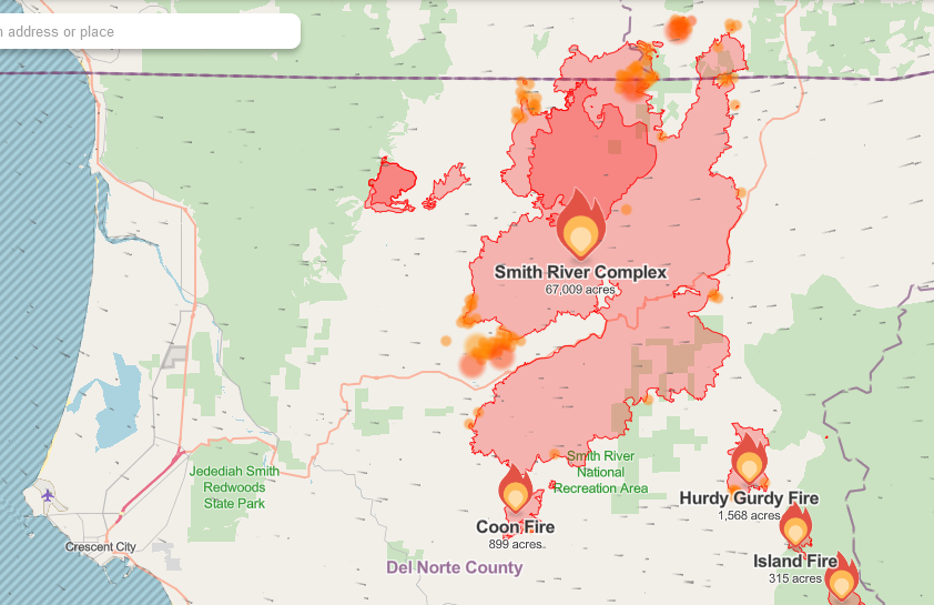
THE SMITH RIVER COMPLEX FIRE IS UP TO 70,000 ACRES AND HAS OVER 2,300 FIRE FIGHTERS ON LOCATION…
|
Rogue River-Siskiyou National Forest -Aggressive Firefighting Continues on Fires Across the Forest
|
|
|
8.26.23
Medford, Ore – Firefighters continue aggressive initial attack efforts on several fires across the Rogue River-Siskiyou National Forest. Helicopter and fixed wing air resources have been fully engaged in suppression activities throughout the day. Several fires on the forest are burning in remote locations. Smokejumpers and rappellers have been utilized to access some of these fires as well as other ground and air resources. Despite unfavorable wind, weather and smoke conditions, resources continue to make progress on the fires that are currently active on the forest. Resource sharing and coordination with our neighboring agencies and Incident Management Teams has been vital in aiding these successes.
The Grayback Fire is burning on the Wild Rivers Ranger District and is estimated to be 25 acres. Smokejumpers and numerous other ground resources are on scene, making great headway on containment line around the head of the fire and mitigating hazard trees that pose a threat to both containment and firefighters on the ground. Aircraft were utilized through the first part of the day until they were grounded due to poor visibility.
The Barklow fire, burning northeast of Gold Beach on the Powers Ranger District, is estimated at eight acres and currently has hose lay and handline around the perimeter. Coos Forest Protective Association and the Flat Fire have assisted the RRSNF with air and ground resources on this fire.
The Winchuck Fire is 0.7 acres and has been 100% lined.
The Anvil Fire is burning in the Grassy Knob Wilderness. It was approximately 20 acres at last report. 12 rappellers were dropped into the fire area today and will begin to build containment line, improve access, construct helispots while other ground resources make their way to the location. Today’s suppression efforts again heavily utilized air tankers to keep the fire from progressing in size.
For current activity on the Smith River Complex North, visit: https://www.facebook.com/smithrivercomplexnorth
For current activity on the Flat Fire, visit: https://www.facebook.com/flatfireoregon2023
A list of recent fire activity and current status follows:
Date/Time Name Status Acres Cause
🔥 08/20/23 Scraggy staffed 3.25 Lightning
🔥 08/20/23 Kanaka mop up 28 Lightning
🔥 08/20/23 Denman Out 1.6 Lightning
🔥 08/25/23 Cedar Staffed 4 Lightning
🔥 08/25/23 Anvil staffed 20 Lightning
🔥 08/25/23 Bolan controlled 0.1 Lightning
🔥 08/25/23 Grayback staffed 25 Pending Investigation
🔥 08/25/23 Barklow staffed 8 Lightning
🔥 08/25/23 Winchuck staffed .7 Lightning
🔥08/25/23 Copper staffed 1 Lightning
_______________________________________________________________________________________
|
|
FIRES; Smith River Complex and other local fires 8-26-23
Morning Update - Smith River Complex Fire South, August 26, 2023
https://www.facebook.com/watch/?ref=embed_video&v=311689714744769
Smith River Complex North Operational Update
https://www.facebook.com/watch/?ref=embed_video&v=1511576929582812
Morning update from Smith River Complex North managers: #SmithRiverComplex North update for Saturday, August 26, 2023 Grants Pass, Ore. –
The north side of the Smith River Complex North remains active with afternoon winds and abundant drought-stressed vegetation contributing to fire spread. Fire personnel are focused on constructing direct and indirect fire lines south and west of Gilligan Butte along the 4402 Road to Hwy 199, and southeast along the 18N11 Road to the 444 Road. They are also installing structure protection systems to minimize immediate threats to local communities and critical infrastructure, as well as cutting hazard trees along Hwy 199 and scouting contingency lines. Thursday’s thunderstorms brought several new fire starts to the region. A new lightning-caused fire was detected near the north side of the Smith River Complex North and was quickly contained. Resources from the Complex are also assisting with the Grayback Fire near Oregon Caves National Park. The air cleared enough on Friday afternoon that aircraft were able to provide fire suppression support. Patchy morning fog in the valleys and smoky conditions in the afternoons will make for poor visibility and limit air operations the next few days. A slight warming and drying trend with moderate afternoon wind gusts is expected to continue through at least Monday. A Level 3 – GO NOW evacuation remains in place for the Hwy 199 area south of O’Brien from mile post 38 into California. A Level 2 – GET SET evacuation is in place for O’Brien and the Takilma area. A Level 1 – GET READY evacuation is in place heading north to Cave Junction. The interactive Fire First Response Map showing evacuation areas can be found at https://rvem.org.
The fire is now 67,009 acres and it remains 0% contained.
Update from Smith River Complex South incident managers: 🚨--Smith River Complex South Update 8/26/23--
Cause: Lightning Acres: 67,009 Containment: 0% Personnel: 2,354 Gasquet, Calif., August 26, 2023. In the wake of the thunderstorms over the area two evenings ago, a deep marine layer was pushed over the fire generating excellent overnight humidity recovery. The marine layer combined with persistent onshore wind created generated cooler and moister conditions. These conditions moderated fire behavior significantly for most of the day yesterday. Given the location of the fire’s perimeter, mostly on the steep rugged terrain, it is impossible to complete a direct attack on most of the fires within the complex. Therefore, an indirect suppression strategy is being implemented to construct control lines that have the highest probability of successfully containing the fire. Many of these lines are along roads and ridgelines and often have been used on previous fires. Fire managers coordinate their burning operations closely with a National Weather Service Incident Meteorologist who provides both short and long-term weather forecasts to inform the best times to complete burnout operations. Yesterday, crews utilized an Unmanned Aerial System (UAS) equipped with a firing device to slowly bring fire down from the Elk Camp Ridge towards the Pacific Power corridor, northeast of the community of Gasquet. The plan is to take advantage of the current weather pattern to contain as much of the western portion of the complex as possible, before potentially adverse weather impacts the fire area later next week. The fire currently has over 2,354 personnel, including 9 Type-1 handcrews. These hand crews completed construction of a fire line from French Hill Road north to Highway 199. This new line will help keep the main fire from impacting the residences on the south side of Highway 199, including those along French Hill Road.
A few new lightning fires in Curry County
Winchuck Fire Is up on USFS road 1107 which runs between the Chetco and Winchuck rivers near the place called Packsaddle Mountain. This is just a few miles west of the North Fork Smith River, just about as far north as the bottom tip if the Kalmiopsis Wilderness area. It’s not that far above the westernmost area of the Smith River complex.
Guy McMahan talked with the local Chief. CFPA is on it 3 engines and helicopter. In deep brush and duff. He COULDN'T" GET TO BY 1107 because of old washout not being repaired. His entire crew on the ready. Being held to a little over an acre. Forgot to say the FS is also on the fire BUT CFPA is in the lead. Chief Lancaster was my contact.
More on Winchuck and Flat Fire.