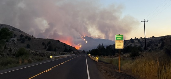
 A wildfire burns near Juntura and U.S. 20.
Wildfires are impacting multiple highways east of the Cascades; travelers should stay alert for changing conditions
For more information, contact ODOT Lead Public Information Officer Kacey Davey
July 26, 2026
SALEM – Wildfires in Oregon are causing widespread travel impacts on several highways, notably U.S. 20 and U.S. 26 between central and eastern Oregon. Wildfires can change direction or grow quickly, causing roads to open or close with little notice. Travelers, including motor carriers, are encouraged to carefully plan their routes, stay alert for changing conditions, and check TripCheck.com for current road conditions, closures and delays.
ODOT staff are working around the clock staffing road closures, setting up traffic control, piloting traffic when possible, assessing damage, coordinating with emergency responders and working to reopen highways as soon as it is safe to do so.
Travelers can help protect firefighters, emergency responders, transportation crews and others by obeying all road closures, flaggers and traffic control devices. Stay out of closed areas and do not go behind closure barricades. Be cautious of emergency vehicles and equipment entering and existing fire camps.
ODOT only closes a highway when necessary for public safety or to allow firefighters and emergency crews to work safely from or along the road. As soon as it is safe, crews will reopen roads. Be aware that highways may reopen before damage is repaired. Travelers should expect burned areas to have missing signs, damaged guardrail or other damaged roadside infrastructure until crews can safely return to make repairs.
If you must travel, plan ahead and be prepared for rapidly changing conditions. Check TripCheck.com before leaving and throughout your trip, especially if traveling through central or eastern Oregon. It will have more up to date information than GPS which may direct you onto forest service roads or other routes that aren’t suitable for highway traffic.
Remember that smoke can reduce visibility quickly, making it difficult to see other vehicles, emergency responders and hazards. Slow down, increase following distance and use extra caution when driving through smoky areas. Power outages near fires may also affect traffic signals and other transportation systems, so treat dark signals as four-way stops and watch for changing traffic patterns.
This is already an incredibly difficult wildfire season for many Oregon communities. Families have been evacuated, people have lost power and road closures have disrupted daily life. We appreciate the patience and understanding of Oregonians as firefighters, emergency responders and road crews across the state continue working to protect lives, communities and critical transportation routes.
# # #
View photos and videos of 2026 wildfires at ODOT’s Flickr page.
|