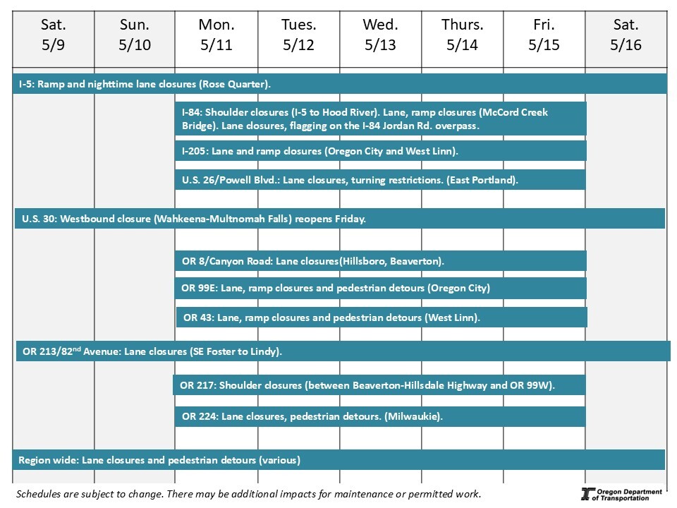
Region 1: Portland metro area
May 9-16, 2026
5/8/2026
Ways to learn about construction taking place:
-
Visit TripCheck. Constantly updated with construction and crash data, TripCheck is the best way to learn about roadway conditions around the state.
-
Scroll down to the highways listed below to see impacts that may affect you. Construction information is shown for one week, giving you the most up-to-date information for targeted areas in the Portland metro area.
-
Review this "quick glance" schedule. Construction information is shown for one week in a visual format, giving you information for targeted areas in the Portland metro area.
*Schedules are subject to change due to weather and other conditions. Traffic impacts may occur for maintenance or other permitted activities.
Interstate 5 – Pacific Highway – I-5 Rose Quarter Improvement Project
Project Description: We are improving safety and congestion where I-5, I-84 and I-405 converge and reconnecting the Albina neighborhood by constructing a highway cover over a portion of I-5.
From summer 2025 through late 2026, we are constructing new stormwater facilities, repairing the concrete deck in a section of I-5 completing a seismic retrofit, extending an existing merging lane on SB I-5, and constructing a new sign structure.
Traffic Impacts: Ramp and nighttime lane closures on I-5.
-
Intermittent nighttime lane closures on I-5 SB between Oregon Convention Center and Burnside Bridge from9 p.m. to 6 a.m. for repair work in the I-5 median. Closures will take place on 5/5-5/15 depending on weather. No detours are required.
-
Note: exit ramps 301 to I-84 and 300B to Morrison Bridge close a couple nights this week. Dates to be determined.
-
Intermittent nighttime lane closures on I-5 NB between Burnside Bridge and Oregon Convention Center from9 p.m. to 6 a.m. for repair work in the I-5 median. Closures will take place 5/8-5/11 depending on weather. No detours are required.
-
Website: https://i5rosequarter.org/current-construction-travel-impacts/
Interstate 84 – Columbia River Highway – McCord Creek Bridge
Project Description: We are preparing to replace the aging bridge that carries I-84 east over McCord Creek near Warrendale in 2025-2026. Replacing the bridge will eliminate a dip in the roadway and increase safety, earthquake resilience, and the lifespan of the highway.
Traffic impacts: Travelers can expect around the clock eastbound and westbound lane closures on I-84 at McCord Creek Bridge.
There will be one lane open in each direction with traffic control crossing over the median. The I-84 onramp at NE Frontage Road is closed.
Project website: www.i84gorgeconstruction.org
Interstate 84 – (Multi-Use Path) Jordan Road Tunnel - Sandy River
Project Description: We are building a new multi-use path parallel to Jordan Road (near I-84 at Exit 18) from the pedestrian tunnel under I-84 to the Sandy River Delta, increasing safer connections for people who walk, bike or roll.
Traffic impacts: Daytime periodic lane closures on Jordan Road, with flaggers directing traffic.
Project website: www.i84gorgeconstruction.org
Interstate 84 - I-5 to Hood River All Roads Transportation Safety (ARTS) Project
Project Description: We’re improving safety and visibility at multiple I-84 interchange ramps between downtown Portland and Hood River by installing new lights, upgrading traffic signal heads, trimming overgrown vegetation and upgrading existing signs through fall 2026.
Traffic Impacts: Daytime shoulder closures.
Project website: www.i84gorgeconstruction.org
Interstate 205 – East Portland Freeway – Improvements Project Phase 1A Abernethy Bridge
Project Description: The I-205 Improvements Project is upgrading the Abernethy Bridge — a critical link on I-205 connecting West Linn and Oregon City — to withstand a major earthquake. We are also realigning I-205 interchanges at OR 43 and OR 99E, making safety improvements for people biking, walking and rolling and building a new sound wall in Oregon City.
Traffic Impacts: Lane and ramp closures in Oregon City and West Linn with pedestrian detours on OR 43 and OR 99E.
- Nighttime ramp closures
-
- I-205 northbound to OR99E (Exit 9 NB) Monday through Thursday from 10:00 pm to 5:00 am and Friday from 10:00 pm to 7:00 am.
- OR43 to I-205 northbound Monday through Thursday from 10:00 pm to 5:00 am and Friday from 10:00 pm to 7:00 am.
- I-205 Southbound to OR43 (Exit 8 SB) Monday through Thursday from 10:00 pm to 5:00 am and Friday from 10:00 pm to 7:00 am
- Nighttime lane closures
- OR 99E Northbound Lanes Monday and Tuesday 8:00 pm to 6:00 am.
- I-205 northbound Monday through Thursday 10:00 pm to 5:00 am and Friday from 10:00 pm to 7:00 am.
- Flagging
- Main St. Monday through Saturday 7:00 a.m. to 5:30 p.m.
U.S. 26 – Powell Boulevard – Outer Powell Transportation Safety Project
Project Description: We are constructing safety improvements to help people travel Outer SE Powell Boulevard more safely from SE 99th Avenue to SE 122nd Avenue and SE 136th Avenue to just east of SE 174th Avenue (the Portland/Gresham city limits). The first phase, from SE 122nd Avenue to SE 136th Avenue, is complete.
The overall Outer Powell Project will add a center turn lane, sidewalks and bike lanes. These improvements reduce the frequency and severity of crashes as well as help people driving, taking transit, walking and biking share the road with fewer conflicts. Pre-construction activities are underway. Road construction is expected to begin spring 2025 and last five years.
Traffic Impacts: Lane closures, traffic shifts, shoulder closures and up to 20-minute traffic holds 8:00 a.m. to 5:00 p.m., weekdays. Temporary sidewalk closures with accessible pedestrian detours.
Possible nighttime work with closures. Travelers can expect congestion during construction. Alternate routes are available. Flaggers may be directing traffic.
Project website: www.OuterPowellSafetyProject.org
U.S. 30 – Historic Columbia River Highway – Multnomah Falls Viaducts
Project description: Two 100 year-old elevated roadways that provide access to Multnomah Falls require repairs to continue providing access to one of Oregon's most iconic sites. The elevated roadways – called viaducts – carry vehicles and bicycles to the Falls and Lodge from the Historic Columbia River Highway. The east viaduct will be closed fall 2025 through spring 2026. Restoration work to the west viaduct on the Historic Columbia River Highway (U.S. 30) between Wahkeena Falls and Multnomah Falls was completed in May 2025.
Traffic impacts: A section of the Historic Columbia River Highway/U.S. 30 between Multnomah Falls and the Oneonta Trailhead is planned to reopen the evening of Friday, May 15.
I-84 is open. Use I-84 Exit 31 or take transit to visit Multnomah Falls. There is no vehicle, pedestrian or bicycle access to Multnomah Falls heading westbound on the Historic Highway from Exit 35. The Oneonta trailhead is open to hikers, with limited parking.
Project website: www.i84GorgeConstruction.org
U.S. 30 BY – NE 42nd Avenue Bridge Replacement
Project Description: Closures are required for the NE 42nd Avenue Bridge Replacement, which will make a seismically safe crossing for an emergency route and provide better access for freight, pedestrians, and people biking on the bridge and NE Lombard Street below the span.
Traffic Impacts: No impacts to U.S. 30 BY.
U.S. 30 BY – Bridge over Private Drive
Project Description: This project restores the bridge on NW Bridge Ave. northwest of the St. Johns Bridge, connecting to U.S. 30.
Traffic Impacts: No Impacts
Website: https://www.oregon.gov/odot/projects/pages/project-details.aspx?project=21704
U.S. 30 BY – St. Johns Bridge – Bridge Repair
Project description: We are improving the long-term safety and lifespan of the St. Johns Bridge by repairing the concrete on the pier columns and arches under the bridge. Repairing the concrete will protect the bridge's steel internal frame and reinforcements from corrosion, maintaining the service life of this beloved Portland Historic Landmark.
Traffic impacts: No traffic impacts.
Project website: https://www.oregon.gov/odot/projects/pages/project-details.aspx?project=37899
OR 8 – Canyon Road – Pedestrian improvement project in Central Beaverton
Project Description: This partnership project between ODOT, City of Beaverton and Metro will improve pedestrian safety on SW Canyon Road (OR 8) from SW Hall Boulevard to SW Cedar Hills Boulevard in Central Beaverton by adding two new crosswalks, a flashing beacon, new lighting and a landscaped center median.
Traffic Impacts: Nighttime lane closures (8:00 p.m. to 5:30 a.m.) on Canyon Road, Monday through Friday.
Project website: OR8construction.org
OR 8 – TV Highway – Pedestrian improvement project in Hillsboro and Forest Grove
Project Description: This safety improvement project in three locations on OR 8 in Hillsboro and Forest Grove includes new sidewalks, an enhanced pedestrian crosswalk, new lighting and upgraded traffic signals.
Traffic Impacts: No traffic impacts.
Project website: OR8construction.org
OR 127 Cornelius Pass – Cornelius Pass Hwy & U.S. 30 ITS Improvement
Project Description: The Cornelius Pass Hwy & U.S. 30 ITS Improvements Project focuses on making Cornelius Pass Highway (Highway 127), between U.S. 26 and U.S. 30, safer and more efficient for travelers. The project includes upgrades to lighting, signal equipment, and signage, as well as new intelligent transportation system (ITS) devices such as traffic cameras, variable message signs, and an activated intersection warning system, bringing it up to the latest Oregon Department of Transportation (ODOT) standards.
Traffic impacts: No traffic impacts.
Project website: tinyurl.com/CorneliusPassUS30
OR 224 – SE 17th Ave and Rusk Rd
Project Description: ODOT is improving safety, paving between SE 17th Avenue and SE 37th Avenue and performing bridge improvements to OR 224 between SE 17th Ave and Rusk Rd.
Traffic impacts: Daytime lane closures on OR 224 in Milwaukie. Sidewalk closures with accessible pedestrian detours.
Project website: tinyurl.com/OR224-17toRusk
OR 224 – Milepost 36.7 maintenance repairs
Project Description: Repairs are being made on OR 224 at milepost 36.7 (approximately 10 miles east of Estacada) after a winter storm event in December.
Traffic impacts: No traffic impacts.
Various Highways – ADA curb ramp construction (Phase 1, 2, 3, 6, Sandy/Molalla)
Project Description: We are bringing over 1,100 sidewalk curb ramps into compliance with Americans with Disabilities Act (ADA) accessibility standards on various highways in Region 1.
Traffic impacts: Lane closures for ADA curb ramp work.
Daytime lane closures and pedestrian detours
- I-405 ramps at N Kerby Ave., N Cook St.
- SE Powell Blvd. at SE 11th
- I-84 ramps at NE 238 Ave.
- OR 217 at SW Denney Rd., SW 105th
- S. 26 at NW 158 Ave., NW Cornell Rd.,
- OR 8 in Hillsboro at SW 2nd, SW Connell Ave., SE 9 Ave., SE 6 Ave., N 31 Ave.
Nighttime lane closures and pedestrian detours
- SE Powell Blvd. at SE 7, 22, 25 Avenues.
- OR 99E at SE 7 Ave.
Shoulder closures
- OR 10 at SW Gibbs St., SW Curry St.,
- OR 213 at Edgemont Dr., Meadow Dr.,
- OR 43 at SW Corbett Ave.
All-hours shoulder closures, pedestrian detours and bikes sharing the roadway
- S. 26 in Sandy at Industrial Way, Ruben Lane, Shelley Ave., Meinig Ave., Bluff Rd., Strauss Ave., Wolfe Dr.
Project website: r1ada.org
Tips for driving safely in work zones
An inattentive driver is the most common cause of work zone crashes. Drivers and their passengers — not workers — make up the majority of work zone fatalities. What you can do:
-
SLOW DOWN!
- Pay attention
- Obey signs and flaggers
Know before you go! Call 511 or visit www.TripCheck.com to check routes, work zones and road and weather conditions before you head out.
|