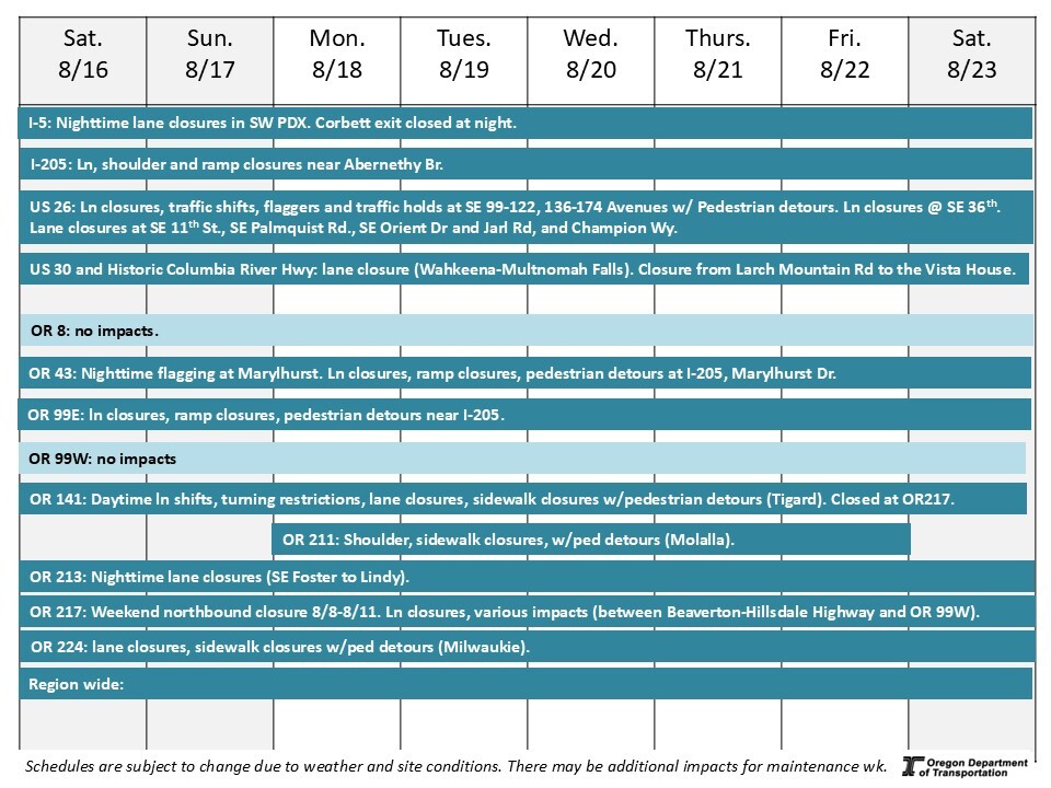
Region 1: Portland metro area
Aug. 16 - Aug. 23, 2025
8/15/2025
Ways to learn about construction taking place:
-
Visit TripCheck. Constantly updated with construction and crash data, TripCheck is the best way to learn about roadway conditions around the state.
-
Scroll down to the highways listed below to see impacts that may affect you. Construction information is shown for one week, giving you the most up-to-date information for targeted areas in the Portland metro area.
-
Review this "quick glance" schedule. Construction information is shown for one week in a visual format, giving you information for targeted areas in the Portland metro area.
*Schedules are subject to change due to weather and other conditions. Periodic traffic impacts may occur for maintenance or other permitted activities.
Maintenance and Permitted Utility Work
There may be impacts throughout the region due to maintenance or permitted activities. Here are some of these impacts.
Traffic impacts:
-
I-5: NB Exit at Corbett closed Aug. 14- Aug. 22 9 a.m. to 5 a.m.
-
OR 127 (Hall Blvd): stationary flagging through Sept. 1 between OR 217 and SW Durham Rd., 9:00 p.m. to 5:00 a.m.
Interstate 5 – Pacific Highway – RealTime Signs
Project Description: ODOT is installing RealTime Variable Advisory Speed (VAS) signs along a busy stretch of Interstate 5 through south Portland from the Ross Island Bridge to Terwilliger Boulevard. Realtime VAS signs give drivers notice to slow down before they reach a problem area — improving traffic flow and helping to reduce rear-end crashes and congestion.
Traffic impacts: Nighttime single lane closures.
Project website: bit.ly/I-5VariableSigns
Interstate 84 – Columbia River Highway – McCord Creek Bridge (utility work)
Project Description: We are preparing to replace the aging bridge that carries I-84 east over McCord Creek near Warrendale in 2025-2026. Replacing the bridge will eliminate a dip in the roadway and increase safety, earthquake resilience, and the lifespan of the highway.
Traffic impacts: No traffic impacts.
Project website: www.i84gorgeconstruction.org
Interstate 205 – East Portland Freeway – Improvements Project Phase 1A Abernethy Bridge
Project Description: The I-205 Improvements Project is part of a regional Urban Mobility Strategy to comprehensively reduce congestion and crashes, while also making travel times shorter and more predictable. The first phase of the project will upgrade the Abernethy Bridge to withstand a major earthquake, improve interchanges at OR 43 and OR 99E, along with improving on- and off- ramps to improve safety. Abernethy Bridge will also be widened to accommodate a third lane in each direction. Final lane configuration will be completed in a future phase.
Traffic Impacts: Lane, shoulder and ramp closures in the project area.
Nighttime lane closure on I-205 northbound Monday through Saturday from 10:00 p.m. to 5:00 a.m.
Nighttime ramp closure from OR 43 to I-205 northbound Monday through Saturday from 10:00 p.m. to 5:00 a.m.
Nighttime ramp closure from I-205 northbound to OR99E Monday through Saturday from 10:00 p.m. to 5:00 a.m.
Nighttime ramp closure from OR99E to I-205 northbound Thursday through Friday from 10:00 p.m. to 5:00 a.m.
OR43 and OR99E lane closure at I-205. Pedestrian detours on OR 43 and 99E.
Project website: i205corridor.org
U.S. 26 – Powell Boulevard at 36th Avenue – Pedestrian Safety Project
Project Description: We are improving safety for people walking, biking or rolling by upgrading the currently unsignalized crosswalk on U.S. 26 (SE Powell Boulevard) and SE 36th Avenue with a new pedestrian-activated beacon, also known as a Rectangular Rapid Flashing Beacon, or RRFB.
Traffic impacts: Single lane closures from 8am – 4pm.
Project website: www.tinyurl.com/SEPowellandSE36thAve
U.S. 26 – Powell Boulevard – Outer Powell Transportation Safety Project
Project Description: We are constructing safety improvements to help people travel Outer SE Powell Boulevard more safely from SE 99th Avenue to SE 122nd Avenue and SE 136th Avenue to just east of SE 174th Avenue (the Portland/Gresham city limits). The first phase, from SE 122nd Avenue to SE 136th Avenue, is complete.
The overall Outer Powell Project will add a center turn lane, sidewalks and bike lanes. These improvements reduce the frequency and severity of crashes as well as help people driving, taking transit, walking and biking share the road with fewer conflicts. Pre-construction activities are underway. Road construction is expected to begin spring 2025 and last five years.
Traffic Impacts: Lane closures, traffic shifts, shoulder closures and up to 20-minute traffic holds 8 a.m. to 5 p.m., weekdays. Temporary sidewalk closures with accessible pedestrian detours.
Possible nighttime work with closures. Flaggers may periodically be directing traffic.
Project website: www.OuterPowellSafety.org
U.S. 30 – Historic Columbia River Highway – Landslide Repair
Project description: We are making repairs due to a landslide on the Historic Columbia River Highway (U.S. 30) east of Larch Mountain Road.
Traffic impacts: The Historic Columbia River Highway closed in both directions (from Milepost 8.7 to Milepost 9.5) between Larch Mountain Rd. and the Vista House. Detour to I-84. Exit 22 at Corbett Hill Road and Exit 28 at Bridal Veil remain open to access destinations along the Historic Highway.
Project website: www.i84GorgeConstruction.org
U.S. 30 – Historic Columbia River Highway – Sidewalk curb ramps
Project description: We are improving safety and access for all by upgrading sidewalk curb ramps to the current Americans with Disabilities Act (ADA) accessibility standards on a section of U.S. 30 (Cascade Avenue and Oak Street in Hood River) from Mt. Adams Avenue to E 2nd Street.
Traffic impacts: No work on site.
Project website: www.i84GorgeConstruction.org
U.S. 30 – Historic Columbia River Highway – Multnomah Falls Viaducts
Project description: Two 100 year-old elevated roadways that provide access to Multnomah Falls require repairs to continue providing access to one of Oregon's most iconic sites. The elevated roadways – called viaducts – carry vehicles and bicycles to the Falls and Lodge from the Historic Columbia River Highway. The east viaduct will be closed fall 2025 through spring 2026.
Traffic impacts: Travelers accessing the west viaduct can expect periodic single lane closures with flaggers directing traffic.
Project website: www.i84GorgeConstruction.org
U.S. 30 BY – St. Johns Bridge – Bridge Repair
Project description: We are improving the long-term safety and lifespan of the St. Johns Bridge by repairing the concrete on the pier columns and arches under the bridge. Repairing the concrete will protect the bridge's steel internal frame and reinforcements from corrosion, maintaining the service life of this beloved Portland Historic Landmark.
Traffic impacts: No traffic impacts.
Project website: https://www.oregon.gov/odot/projects/pages/project-details.aspx?project=37899
U.S. 30 BY – North Lombard Street, NE Lombard Street, NE Killingsworth Street, NE Sandy Boulevard – sidewalk curb ramps
Project Description: This project rebuilds 300 sidewalk curb ramps at unsignalized intersections along U.S. 30 Bypass in Portland between N. Syracuse Street and NE 165th Avenue to meet ADA accessibility standards.
Traffic Impacts: No traffic impacts.
Project website: www.R1ADA.org
OR 8 – TV Highway – fiber optic cable from OR 217 to SW 198th Avenue
Project Description: We are installing new overhead and underground fiber optic cable where gaps exist along OR 8 between SW 198th Avenue in Aloha to OR 217 in Beaverton.
Traffic Impacts: No Impacts.
Project website: OR8construction.org
OR 8 – TV Highway – pedestrian and bicycle improvements SW 153rd Drive to SW 182nd Avenue
Project description: This project improves safety for people walking, rolling and bicycling by installing a crosswalk with a pedestrian-activated flashing beacon at the intersection of OR 8 at SW 174th Avenue in Aloha and a buffered bicycle lane from SW 153rd Drive to SW 182nd Avenue.
Traffic impacts: No impacts.
Project website: OR8construction.org
OR 43 at Marylhurst Drive Intersection Improvements
Project Description: This project will reduce conflicts and improve safety on OR 43 (Willamette Drive) for travelers at the Marylhurst Drive intersection.
Traffic impacts: Nighttime flagging and traffic holds 8/22-8/24. Single lane closures at OR 43 and Marylhurst Dr. with sidewalk closures and pedestrian detours.
Website: Bit.ly/ODOT-OR43-Project
OR 141 – Hall Boulevard – SW Hemlock Street and SW Spruce Street - Pedestrian Safety Improvements
Project Description: In partnership with the City of Tigard and Washington County, we are working on a project to enhance safety on Hall Boulevard (Oregon Hwy 141). This project will install two new enhanced pedestrian crossings, or Rectangular Rapid Flashing Beacons, across SW Hall Boulevard at the intersections of SW Hemlock and SW Spruce streets.
Traffic Impacts: Lane and shoulder closures on Hall Blvd. (OR 141) at SW Hemlock and SW Spruce Streets are expected from 8:00 a.m. to 4:00 p.m. with possible flagging. Turns onto Spruce St. are restricted. Sidewalk closures with accessible pedestrian detours.
Project website: https://tinyurl.com/SWHallBlvdRRFBs
OR 141 – Hall Boulevard – ADA curb ramp construction
Project Description: We are bringing over 100 sidewalk curb ramps into compliance with Americans with Disabilities Act (ADA) accessibility standards in Tigard along SW Hall Boulevard (OR 141) between OR 99W and SW Durham Road, and on SW 72nd Avenue between SW Gonzaga Street and SW Varns Street.
Traffic Impacts: Lane shifts and sidewalk closures with accessible pedestrian detours Hall Boulevard at SE Burnham St, SW Sattler/Ross St, SW Avon St (SW Avon Pl) and SE Wall St, and various intersections on SW 72nd Avenue from 9:00 a.m. to 3:00 p.m. weekdays.
- Left turn lanes closed:
- SB Hall Blvd onto EB Ross St
- SB Hall Blvd onto EB Bonita St
- NB Hall Blvd onto WB Burnham St
- SB Hall Blvd onto EB Wall St
Project website: https://www.oregon.gov/odot/projects/pages/project-details.aspx?project=22431
Oregon 211 – Main Street – Private Development (Molalla)
Project Description: A private development is underway off OR 211 near Ona Way in Molalla.
Traffic impacts: Shoulder closures. Accessible pedestrian detours available during sidewalk closures.
Oregon 213 – SE 82nd Avenue – Paving and Safety Improvements
Project Description: We are repaving and making safety improvements on SE 82nd Avenue from SE Foster Road to SE Thompson Road. We will repave SE 82nd Avenue in both directions between SE Foster Road and SE Lindy Street. Pedestrian safety improvements from SE Foster to SE Thompson Road include four new Rectangular Rapid Flashing Beacons (RRFBs), upgrades to curb ramps that meet Americans with Disabilities Act (ADA) requirements and adding new sidewalks between SE Clatsop Street and SE Cornwell Street.
Traffic impacts: Nighttime single lane closures are possible on SE 82 Ave. (OR 213) between SE Foster Rd. and SE Lindy St. from 7:00 p.m. to 7:00 a.m.
Project website: tinyurl.com/82ndAveFosterToThompson
Oregon 217 – Beaverton-Tigard Highway – Auxiliary Lanes
Project Description: This project will address long-standing congestion on OR 217 between Beaverton-Hillsdale Highway and OR 99W due to too many closely spaced interchanges: 10 interchanges in just over seven miles! This is some of the shortest merging spacing in the region.
Traffic Impacts: Weekend directional closures, and various impacts in the project area. Hall Boulevard over OR 217 in Tigard is temporarily closed to replace the bridge.
Expect lane and shoulder closures on OR 217, various on- and off-ramps, and on local roads near the highway ramps. Various on- and off-ramps temporarily narrowed.
- Nighttime single lane closures on OR 217 8/7-8/9, 8/11-8/16.
- OR 217 north closed between OR 99W and Scholls Ferry Road beginning Friday night, August 8, at 9 p.m. and ending Monday morning, August 11, by 5 a.m. The following northbound ramps will also close for the weekend:
- 72nd on-ramp.
- OR 99W on-ramps.
- Greenburg Road off-ramp.
- Greenburg Road on-ramp.
- Scholls Ferry Road off-ramp.
- Detour is via I-5 through Portland, I-405, and U.S. 26.
- Nighttime right lane closures on the OR 99W overpass 8/4-8/9.
Project website: www.hwy217.org
OR 224 – SE 17th Ave and Rusk Rd
Project Description: ODOT is improving safety, paving between SE 17th Avenue and SE 37th Avenue and performing bridge improvements to OR 224 between SE 17th Ave and Rusk Rd.
Traffic impacts: Lane closures, lane shifts and pedestrian detours on OR 224 between SE Oak and SE Harrison 7 a.m. to 3 p.m. Monday – Friday. Lane closure at SE Lake Rd. at OR 224 Ramps.
Project website: tinyurl.com/OR224-17toRusk
Various Highways – ADA curb ramp construction (Phase 1)
Project Description: We are bringing over 300 sidewalk curb ramps into compliance with Americans with Disabilities Act (ADA) accessibility standards on various highways in Region 1.
Traffic impacts: Lane closures are anticipated in Troutdale and Hood River.
-
Hood River: One traffic lane on the Mt. Hood Hwy (U.S. 26) may be closed daily between 9 a.m. to 3 p.m. at SE 11th St, SE Palmquist Rd, SE Orient Dr., SE Jarl Rd. and SE Champion Way.
-
Troutdale: One traffic lane closed 6:00 p.m. to 6:00 a.m. on Marine Dr. and Frontage Rd.
Project website: r1ada.org
Various Highways – West ARTS
Project Description: The ARTS Program aims to reduce serious crashes at various intersections on state highway and on local roads. Intersections typically have high rates of crashes. The West ARTS program improves safety at intersections and streets in the west Portland metro area. Improvement corridors include U.S. 30, Tualatin Valley Highway (OR 8), Beaverton-Hillsdale Highway (OR 10), Barbur Boulevard (OR 99W), Macadam Avenue (OR 99E) and Hall Boulevard (OR 141).
Traffic impacts: Single lane closures at Nimbus and Hall Blvd.
Project website: www.bit.ly/ARTSProgram
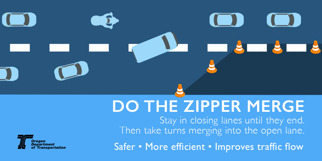
Tips for driving safely in work zones
An inattentive driver is the most common cause of work zone crashes. Drivers and their passengers — not workers — make up the majority of work zone fatalities. What you can do:
-
SLOW DOWN!
- Pay attention
- Obey signs and flaggers
Know before you go! Call 511 or visit www.TripCheck.com to check routes, work zones and road and weather conditions before you head out.
|