Region 1: Portland metro area
Sept. 21-28, 2024
Sept. 20, 2024
24-35
There are three ways to learn about construction taking place the week of Sept. 21-28, 2024.
-
Visit TripCheck. Constantly updated with construction and crash data, TripCheck is the best way to learn about roadway conditions around the state.
-
Scroll down to the highways listed below to see impacts that affect you. Construction information is shown for one week, giving you the most up-to-date information for targeted areas in the Portland metro area.
-
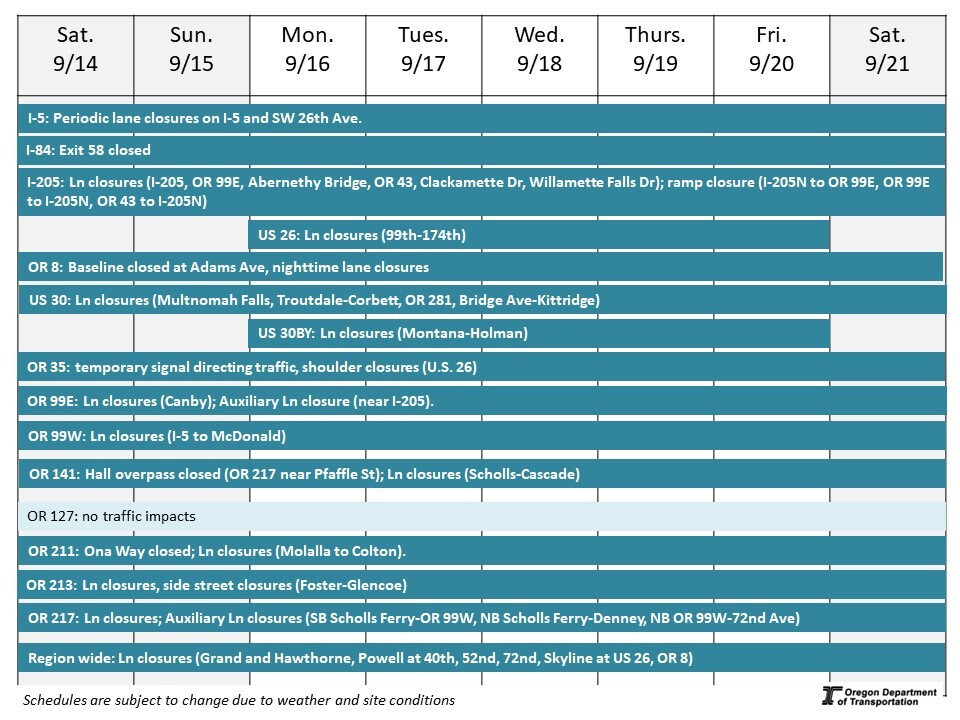
Review this "quick glance" schedule. Construction information is shown for one week in a visual format, giving you information for targeted areas in the Portland metro area.
*Schedules are subject to change due to weather and other conditions.
Interstate 5 – Pacific Highway – I-5 Over 26th Avenue Improvements
Project description: Improves the I-5 bridge over SW 26th Avenue in Southwest Portland with a new structure and upgrades SW 26th Avenue with better lighting, bike lanes, and sidewalks.
Traffic impacts: Periodic lane closures on I-5 and SW 26th Ave.
Project website: bit.ly/swi-5repair
Interstate 84 – Columbia River Highway – Mitchell Point Tunnel
Project Description: The iconic Mitchell Point Tunnel was a highlight of the original Historic Highway, but the construction of Interstate 84 destroyed the tunnel. Now, we are constructing a new tunnel and Historic Highway State Trail segment adjacent to I-84 east near Exit 58.
Traffic Impacts: I-84 east Exit 58 closed around the clock.
Project website: www.i84gorgeconstruction.org
Interstate 205 – East Portland Freeway – Improvements Project Phase 1A Abernethy Bridge
Project Description: The I-205 Improvements Project is part of a regional Urban Mobility Strategy to comprehensively reduce congestion and crashes, while also making travel times shorter and more predictable. The first phase of the project will upgrade the Abernethy Bridge to withstand a major earthquake, improve interchanges at OR 43 and OR 99E, along with improving on- and off- ramps to improve safety. Abernethy Bridge will also be widened to accommodate a third lane in each direction. Final lane configuration will be completed in a future phase.
Traffic Impacts: Single lane closures on Clackamette Drive, Willamette Falls Drive. Auxiliary lane closure on OR 99E north. Pedestrian detours on OR 43 and OR 99E.
Project website: i205corridor.org
U.S. 26 – Powell Boulevard – Outer Powell Transportation Safety Project
Project Description: We are constructing safety improvements to help people travel Outer SE Powell Boulevard more safely from SE 99th Avenue to SE 122nd Avenue and SE 136th Avenue to just east of SE 174th Avenue (the Portland/Gresham city limits). The first phase, from SE 122nd Avenue to SE 136th Avenue, is complete.
The overall Outer Powell Project will add a center turn lane, sidewalks and bike lanes. These improvements reduce the frequency and severity of crashes as well as help people driving, taking transit, walking and biking share the road with fewer conflicts. Pre-construction activities are underway through 2024. Road construction is expected to begin spring 2025 and last five years.
Traffic impacts: Lane closures, traffic shifts, shoulder closures and up to 20-minute traffic holds weekdays.
Project website: www.OuterPowellSafety.org
U.S. 26 – Sunset Highway – Paving: Cornelius Pass Road to Glencoe Road
Project description: This project repaves U.S. 26 (Sunset Highway) in both directions from Cornelius Pass Road to Glencoe Road, repairs two bridges and replaces a culvert under the highway.
Traffic impacts: No traffic impacts.
Project website: bit.ly/US26paving
U.S. 26 – Sunset Highway – Tanner Trunk Sewer (Portland BES)
Project description: City of Portland will begin work on the Tanner Trunk Sewer Project.
Traffic impacts: Single lane closure in both directions on U.S. 26 near Exit 72 from 9 p.m. Friday, Sept. 20 to 5 a.m. Monday, Sept. 23.
Project website: https://www.portland.gov/bes/improvements/construction/tanner-trunk-sewer-project
U.S. 26 – Mt. Hood Highway – Paving Brightwood to Zigzag
Project Description: We are paving and completing multimodal safety improvements project on U.S. 26 between the Brightwood and Zigzag areas.
Traffic impacts: Periodic nighttime single lane closures weekdays.
Project website: https://www.oregon.gov/odot/projects/pages/project-details.aspx?project=21599
U.S. 30 – NW St. Helens Road – NW Industrial Paving Project
Project description: We are making safety improvements for people walking, biking, driving and moving freight on U.S. 30 (NW St. Helens Road), between NW Bridge Avenue and NW Kittridge Avenue. We are repaving the roadway, replacing traffic signals, adjusting vehicle lane widths, building curb ramps to meet Americans with Disabilities Act (ADA) requirements and improving conditions for people biking.
Traffic impacts: Periodic daytime lane closures. Pedestrian detours. Bicycles use roadway travel lanes.
Project website: bit.ly/NWIndustrialAreaRepavement
U.S. 30 – Historic Columbia River Highway – Sign upgrades
Project description: Install new curve warning signs and upgrade other signs to improve safety along the drivable sections of the Historic Highway between Troutdale and Hood River.
Traffic impacts: Nighttime single lane closures with flaggers directing traffic between Troutdale and Corbett.
Project website: www.i84GorgeConstruction.org
U.S. 30 – Historic Columbia River Highway – Multnomah Falls Viaducts
Project description: Two 100 year-old elevated roadways that provide access to Multnomah Falls require repairs to continue providing access to one of Oregon's most iconic sites. The elevated roadways – called viaducts – carry vehicles and bicycles to the Falls and Lodge from the Historic Columbia River Highway. The west viaduct will be closed fall 2024 through spring 2025. The east viaduct will be closed fall 2025 through spring 2026.
Traffic impacts: Lane closure with flaggers directing traffic at Multnomah Falls around-the-clock. Expect delays.
The Historic Highway is restricted to vehicles under 35-feet in length between Larch Mountain and Ainsworth State Park (mileposts 8.76-22). An 11-ton weight restriction remains in place just west of Multnomah Falls until further notice.
Project website: www.i84GorgeConstruction.org
U.S. 30 BY – St. Johns Bridge – Bridge Repair
Project description: We are improving the long-term safety and lifespan of the St. Johns Bridge by repairing the concrete on the pier columns and arches under the bridge. Repairing the concrete will protect the bridge's steel internal frame and reinforcements from corrosion, maintaining the service life of this beloved Portland Historic Landmark.
Traffic impacts: No traffic impacts.
Project website: https://www.oregon.gov/odot/projects/pages/project-details.aspx?project=37899
U.S. 30 BY – North Lombard Street, NE Lombard Street, NE Killingsworth Street, NE Sandy Boulevard – sidewalk curb ramps
Project Description: This project rebuilds 300 sidewalk curb ramps at unsignalized intersections along U.S. 30 Bypass in Portland between N. Syracuse Street and NE 165th Avenue to meet ADA accessibility standards.
Traffic Impacts: Around-the-clock lane closures between Montana Avenue and NE 74th Street. Pedestrian detours.
Project website: www.R1ADA.org
Oregon 35 – Mt. Hood Highway – OR 35 Overpass at U.S. 26 Bridge Deck Repair Project
Project Description: This project will resurface the bridge deck on the Oregon Highway 35 overpass at U.S. 26 interchange in Mt. Hood, east of Government Camp. Making these repairs now increases the service life of the road and provides a smoother, safer ride for travelers.
Traffic Impacts: Lane closures on OR 35 with traffic directed by a temporary signal. Shoulder closures weekdays on U.S. 26.
Project website: tinyurl.com/OR35atUS26
Oregon 99E – Kellogg Creek Restoration and Community Enhancement Project
Project Description: The Kellogg Creek restoration and community enhancement project will reestablish fish passage into the Kellogg-Mt. Scott watershed, restore lower Kellogg Creek habitat and its floodplain through Milwaukie, improve long-term community resiliency and access to nature, and modernize vulnerable multi-modal transportation infrastructure. This summer, sediment sample collection will begin in the impoundment area behind Kellogg Dam using large, on-water equipment. Sediment has been accumulating behind the dam since it was built in the mid-1800s, and large equipment is required to collect samples in places where the accumulation is deep. The sampling equipment will be launched from Kronberg Park and Oregon Highway 99E (SE McLoughlin Boulevard) bridge near Milwaukie Bay Park.
Traffic Impacts: No traffic impacts.
Project website: https://www.milwaukieoregon.gov/kellogg
Oregon 99E – Pacific Highway East – Paving in Canby
Project description: This project will repave and reconstruct sections of Oregon 99E between South Pine Street and Southwest Berg Parkway in Canby and make safety improvements.
Traffic impacts: Lane and median closures between Redwood Street and Pine Street and near Berg Parkway.
Project website: Bit.ly/canbypaving
Oregon 99W – Pacific Highway West – Paving: I-5 to McDonald Street
Project description: The project area begins where OR 99W crosses Interstate 5 near SW 64th Avenue. It continues along OR 99W south to SW McDonald Street in Tigard. It will create a fully connected sidewalk network in the corridor, smoother and safer road surface, increase bike lane connectivity, and reconstruct sidewalk curbs so they comply with Americans with Disabilities Act standards.
Traffic impacts: Nighttime single lane closures 9 p.m. to 5 a.m. Flaggers directing traffic at intersections throughout the project area.
The dedicated right turn lanes form northbound OR99W to Main Street and from Johnson Street onto OR99W south are closed. Right turns are still permitted.
Daytime single lane closures at Pacific Drive 9 a.m. to 3 p.m. weekdays.
Project website: tinyurl.com/OR99Wpaving
Oregon 127 – NW Cornelius Pass Road – NW Skyline Boulevard Storage Site
Project Description: A new ODOT storage site is being constructed at the southeast corner of OR 127 and NW Skyline Boulevard to provide maintenance crews with access to supplies and equipment for maintaining safety and operations of NW Cornelius Pass Road and during winter weather events.
Traffic Impacts: No traffic impacts.
Oregon 211 – Main Street – Private Development (Molalla)
Project Description: A private development is underway off OR 211 near Ona Way in Molalla.
Traffic impacts: Nighttime lane closures with flaggers directing traffic 7 p.m. to 5 a.m. for utility work.
Shoulder closures and pedestrian detours. Ona Way is closed at OR 211.
Oregon 211 – Woodburn-Estacada Highway – Safety Corridor
Project Description: The Oregon Department of Transportation designated eight miles of OR 211 from Molalla to Colton (milepost 14.0 to 22.0) as a Safety Corridor in October 2021 in response to high crash rates. ODOT builds safety improvements in 2024 to reduce crashes with new signage, striping, lighting and rumble strips..
Traffic impacts: Lane closures with flaggers directing traffic 7 a.m. to 3 p.m. on OR 211 from Molalla to Colton.
Periodic nighttime lane closures with flaggers directing traffic.
Website: tinyurl.com/OR211SafetyCorridor
Oregon 213 – SE 82nd Avenue – Paving and Safety Improvements
Project Description: We are repaving and making safety improvements on SE 82nd Avenue from SE Foster Road to SE Thompson Road. We will repave SE 82nd Avenue in both directions between SE Foster Road and SE Lindy Street. Pedestrian safety improvements from SE Foster to SE Thompson Road include four new Rectangular Rapid Flashing Beacons (RRFBs), upgrades to curb ramps that meet Americans with Disabilities Act (ADA) requirements and adding new sidewalks between SE Clatsop Street and SE Cornwell Street.
Traffic impacts: Daytime and nighttime lane closures between Foster Road and Glencoe Road.
Partial side street closures at Harney.
Project website: tinyurl.com/82ndAveFosterToThompson
Oregon 217 – Beaverton-Tigard Highway – Auxiliary Lanes
Project Description: This project will address long-standing congestion on OR 217 between Beaverton-Hillsdale Highway and OR 99W due to too many closely spaced interchanges: 10 interchanges in just over seven miles! This is some of the shortest merging spacing in the region.
Traffic impacts: One direction of OR 217 closed at a time from 11 p.m. to 5 a.m. between Greenburg Road and OR 99W beginning Monday through Oct. 3.
All lanes of OR 217 south closed overnight Sept. 23-25 and Oct. 2-3. All lanes of OR 217 north closed overnight Sept. 26-Oct. 1.
Six southbound ramps will close 9 p.m. Friday, Sept. 27 and reopen 5 a.m. Monday, Sept. 30: Allen Boulevard off-ramp, Denney Road on-ramp, Hall Boulevard off- and on-ramps, Scholls Ferry off- and on-ramps.
Nighttime single lane closures on OR 217 in both directions weekdays.
Daytime closure of the auxiliary lane on northbound OR 217 between 72nd Avenue and OR 99W 6 a.m. to 2 p.m. Monday through Saturday.
Ongoing closures: Hall Boulevard over OR 217 in Tigard is closed through fall 2024 to replace the bridge. One lane of westbound Hall Boulevard is closed around-the-clock for several months between Scholls Ferry Road and Cascade Avenue. One lane in each direction is closed around-the-clock on the Scholls Ferry Road overpass for several months. Auxiliary lane closures on OR 217 south from Scholls Ferry Road to OR 99W and on OR 217 north from Scholls Ferry Road to Denney Road. Expect shoulder closures on OR 217, various on- and off-ramps, and on local roads near the highway ramps. Various on- and off-ramps temporarily narrowed. Pedestrian detours on the Hall Boulevard overpass in Beaverton, and at the end of the OR 99W southbound off-ramp.
Project website: www.hwy217.org
Oregon 217 – Beaverton-Tigard Highway – Pipeline (Willamette Water Supply)
Project Description: The Willamette Water Supply Program is adding a seismically-resilient water supply for Tualatin Valley Water District, City of Hillsboro, and City of Beaverton water customers.
Traffic impacts: No traffic impacts.
Project website: www.OurReliableWater.org/mpe
Various Highways – Central ARTS
Project Description: The ARTS Program aims to reduce serious crashes at various intersections on state highway and on local roads. Intersections typically have high rates of crashes. The Central ARTS program improves safety at intersections and streets in the central Portland metro area. Improvement corridors include U.S. 30 Bypass, Powell Boulevard (U.S. 26), Foster Road, and Interstate 205.
Traffic impacts: Single lane closures on SE Grand at SE Hawthorne and Powell Boulevard at SE 40th, 52nd and 72nd Avenues.
Project website: www.bit.ly/ARTSProgram
Various Highways – West ARTS
Project Description: The ARTS Program aims to reduce serious crashes at various intersections on state highway and on local roads. Intersections typically have high rates of crashes. The West ARTS program improves safety at intersections and streets in the west Portland metro area. Improvement corridors include U.S. 30, Tualatin Valley Highway (OR 8), Beaverton-Hillsdale Highway (OR 10), Barbur Boulevard (OR 99W), Macadam Avenue (OR 99E) and Hall Boulevard (OR 141).
Traffic impacts: Daytime single lane closures on Skyline Boulevard at U.S. 26. Daytime and nighttime single lane closures on Hall Boulevard at Cedar Hills.
Project website: www.bit.ly/ARTSProgram
Various Highways – Washington County ARTS
Project Description: The ARTS Program aims to reduce serious crashes at various intersections on state highway and on local roads. Intersections typically have high rates of crashes. This ARTS project improves safety at intersections and streets in Washington County. Improvements include 54 intersections on OR 8, OR 10, OR 47 and OR 219.
Traffic impacts: No traffic impacts.
Project website: tinyurl.com/WACountyARTS
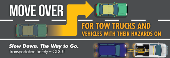
Tips for driving safely in work zones
An inattentive driver is the most common cause of work zone crashes. Drivers and their passengers — not workers — make up the majority of work zone fatalities. What you can do:
-
SLOW DOWN!
- Pay attention
- Obey signs and flaggers
Know before you go! Call 511 or visit www.TripCheck.com to check routes, work zones and road and weather conditions before you head out.
|