Region 1: Portland metro area
September 3-10, 2022
Sept. 2, 2022
22-35
There are three ways to learn about construction taking place the week of Sept. 3-10, 2022.
-
Visit TripCheck. Constantly updated with construction and crash data, TripCheck is the best way to learn about roadway conditions around the state.
-
Scroll down to the highways listed below to see impacts that affect you. Construction information is shown for one week, giving you the most up-to-date information for targeted areas in the Portland metro area.
-
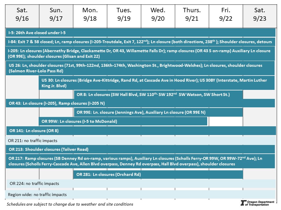
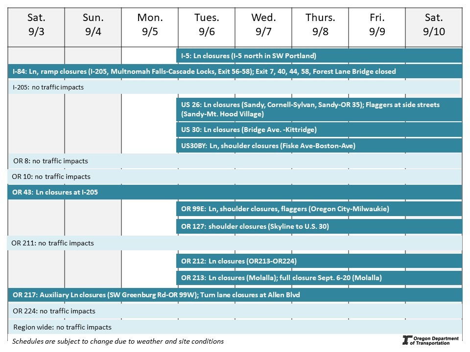
Review this "quick glance" schedule. Construction information is shown for one week in a visual format, giving you information for targeted areas in the Portland metro area.
*Schedules are subject to change due to weather and other conditions.
Impacts will be minimized from noon on Friday, Sept. 2 through Monday, Sept. 5 for the holiday.
Interstate 5 – Pacific Highway – Rose Quarter Investigations
Project Description: This project will conduct geotechnical exploration work in the I-5 Rose Quarter Improvement Project area along I-5.
Traffic Impacts: No traffic impacts.
Project website: www.i5RoseQuarter.org
Interstate 5 – Pacific Highway – SW Portland Ramp Improvements
Project Description: ODOT is repairing three ramps that access I-5 in SW Portland. These structural improvements will maintain and extend the life of our roadway system and give travelers a smoother ride.
Traffic Impacts: Nighttime single and double lane closures on northbound I-5 from 7:30 p.m. to 5:30 a.m. Tuesday through Saturday.
Project website: https://bit.ly/swi-5repair
Interstate 5 – Pacific Highway – Paving from I-205 to Wilsonville
Project Description: ODOT is repaving 5 miles of I-5 between the I-205 interchange and the Boone Bridge over the Willamette River.
Traffic Impacts: Nighttime single lane and ramp closures at Miley Road.
Project website: https://bit.ly/PavingI-5
Interstate 84 – Columbia River Highway – A Better Red (TriMet)
Project description: TriMet is constructing a new bridge over I-84 at Gateway as part of its Better Red Project.
Traffic impacts: Nighttime ramp closures of Eastbound Exit 7 Thursday through Sunday nights. Nighttime single lane closures on I-84 west.
Shoulder closure on I-205 north between Glisan Street and Exit 22, on I-84 east and west.
Project website: https://trimet.org/betterred/
Interstate 84 – Columbia River Highway – Paving
Project Description: Paving between Multnomah Falls and Cascade Locks; repair the aging floor of the historic Toothrock Tunnel and several bridges.
Traffic impacts: Nighttime lane closures from 7 p.m. to 7 a.m. Tuesday through Thursday nights. Nighttime off-ramp closures at Exit 35 east or west and Exits 40 and 44 westbound.
Periodic shoulder closures.
Project website: www.i84gorgeconstruction.org
Interstate 84 – Columbia River Highway – Culvert repair
Project Description: Culvert repair along I-84 between Corbett and Multnomah Falls.
Traffic impacts: No traffic impacts.
Project website: www.i84gorgeconstruction.org
Interstate 84 – Columbia River Highway – Forest Lane Bridge Raising
Project Description: In Cascade Locks, ODOT is raising the Forest Lane bridge over Interstate 84 to accommodate tall or over-height trucks.
Traffic impacts: Forest Lane Bridge closed over I-84.
Project website: www.i84gorgeconstruction.org
Interstate 84 – Columbia River Highway – Viento State Park to Mitchell Point Trail
Project Description: This 2.7-mile segment of trail connects the existing Historic Highway State Trail at the Viento Trailhead to Mitchell Point and includes reconnecting 0.67 miles of original sections of the Historic Highway.
Traffic impacts: Periodic daytime single lane closures Tuesday through Thursday on I-84 east near Viento State Park.
Project website: www.i84gorgeconstruction.org
Interstate 84 – Columbia River Highway – Mitchell Point Tunnel
Project Description: The iconic Mitchell Point Tunnel was a highlight of the original Historic Highway, but the construction of Interstate 84 destroyed the tunnel. Now, we are constructing a new tunnel and Historic Highway State Trail segment adjacent to I-84 east near Exit 58.
Traffic Impacts: I-84 Exit 58 to Mitchell Point Overlook closed around-the-clock.
Project website: www.i84gorgeconstruction.org
Interstate 205 – East Portland Freeway – Exit Ramps at Division Street
Project Description: ODOT is improving safety around the intersection of I-205, SE Division Street and SE 96th Avenue through lane and ramp reconfigurations, signal improvements, new accessible curb ramps, and buffered bike lanes.
Traffic Impacts: Periodic shoulder closures.
Project website: https://tinyurl.com/i205DivisionRamps
Interstate 205 – East Portland Freeway – Improvements Project Phase 1A Abernethy Bridge
Project Description: The I-205 Improvements Project is part of a regional Urban Mobility Strategy to comprehensively reduce congestion and crashes, while also making travel times shorter and more predictable. The first phase of the project will upgrade the Abernethy Bridge to withstand a major earthquake, improve interchanges at OR 43 and OR 99E, along with improving on- and off- ramps to improve safety. Abernethy Bridge will also be widened to accommodate a third lane in each direction. Final lane configuration will be completed in a future phase.
Traffic Impacts: Single lane closure on OR 43 north and Clackamette Drive. Auxiliary lane closure on OR 99E north.
Project website: i205corridor.org
U.S. 26 – Sunset Highway – Cornell Road to Sylvan interchange paving project
Project Description: We are improving approximately six miles of U.S. 26 by repaving both directions from Cornell Road to the Sylvan interchange, including several on- and off-ramps. We are also repairing bridges and bridge joints in the project area and upgrading curb ramps at each repaved on- and off-ramp to meet Americans with Disabilities Act (ADA) standards.
Traffic impacts: Periodic shoulder closures.
Project website: bit.ly/us26pavingcornelltosylvan
U.S. 26 – Mt. Hood Highway – Ten Eyck Road/Wolf Drive to Vista Loop Drive sidewalk
Project description: We are installing over half a mile of six-foot-wide sidewalk on the north side of U.S. 26 between Ten Eyck Road/Wolf Drive and Vista Loop Drive on the east edge of Sandy to give people a safe place to walk and roll.
Traffic impacts: Daytime single lane closures on U.S. 26 west.
Project website: https://tinyurl.com/odotUS26TenEyck
U.S. 26 – Mt. Hood Highway – Culverts
Project Description: This project repairs 15 culverts under U.S. 26 between Southeast Kelso Road in Sandy and Frog Lane Snow Park east of OR 35.
Traffic Impacts: No traffic impacts.
Project website: http://www.bit.ly/us26culverts
U.S. 26 – Mt. Hood Highway – sidewalk curb ramps
Project Description: This project rebuilds sidewalk curb ramps along U.S. 26 in Sandy between Royal Lane and Revenue Avenue to meet ADA accessibility standards. Work will be complete the end of 2021.
Traffic Impacts: Pedestrian detours.
Project website: www.R1ADA.org
U.S. 26 – Mt. Hood Highway – Maintenance Paving
Project Description: Maintenance paving work on U.S. 26 between Rhododendron and OR 35.
Traffic Impacts: Daytime lane closures from 7 a.m. to 7 p.m. Tuesday and Wednesday on U.S. 26 east between Government Camp and OR 35.
U.S. 30 (NW St. Helens Road) – NW Industrial Paving Project
Project description: We are making safety improvements for people walking, biking, rolling, driving and moving freight on U.S. 30 (NW St. Helens Road), between NW Bridge Avenue and NW Kittridge Avenue. We are repaving the roadway, replacing traffic signals, adjusting vehicle lane widths, building curb ramps to meet Americans with Disabilities Act (ADA) requirements and improving conditions for people biking.
Traffic impacts: Daytime single lane closures. Pedestrian detours.
Project website: bit.ly/NWIndustrialAreaRepavement
U.S. 30 BY – N Lombard Street – Safety Project
Project description: ODOT is building safety and travel-time predictability improvements for all travelers along U.S. 30 Bypass/North Lombard Street between North Fiske Avenue and North Boston Avenue. Construction impacts include lane closures through summer 2022.
Traffic impacts: Periodic daytime lane closures.
Project website: bit.ly/LombardSafetyProject
Oregon 8 – Adair and Baseline Streets – Sidewalk curb ramps
Project Description: This project rebuilds sidewalk curb ramps along OR 8 from N. 17th Avenue to Yew Street to meet ADA accessibility standards.
Traffic Impacts: No traffic impacts.
Project website: www.R1ADA.org
Oregon 99E – McLoughlin Boulevard – Sidewalk curb ramps
Project Description: This project rebuilds sidewalk curb ramps along OR 99E from Oregon City to Milwaukie to meet ADA accessibility standards. Work will be complete the end of 2022.
Traffic Impacts: Flaggers directing traffic with lane and shoulder closures along McLoughlin Boulevard. Lane shifts and pedestrian detours.
Project website: www.R1ADA.org
Oregon 99W – SW Barbur Boulevard – Barbur Crossroads Project
Project Description: This project improves safety where Barbur Boulevard, Capitol Highway and Taylors Ferry meet with new pedestrian and bike facilities and a traffic signal change.
Traffic Impacts: No traffic impacts.
Project Website: bit.ly/barburcrossroads
Oregon 127 – Cornelius Pass Road – Arterial corridor management project
Project Description: This project will install new traffic signal controllers, vehicle detection equipment, traffic monitoring cameras and curve warning signs on Cornelius Pass Road between U.S. 30 and OR 8.
Traffic Impacts: Daytime shoulder closures from Skyline Boulevard to U.S. 30.
Project website: tinyurl.com/CorneliusPassITS
Oregon 211 – Woodburn-Estacada Highway – sidewalk curb ramps
Project Description: This project rebuilds sidewalk curb ramps along OR 211 in Molalla between Ridings Avenue and Mathias Road and in Estacada between 2nd Avenue and Acacia Road to meet ADA accessibility standards.
Traffic Impacts: No traffic impacts.
Project website: www.R1ADA.org
Oregon 212 – Clackamas Highway – Traffic Signal Upgrades
Project Description: We are installing modern traffic signal controllers, additional vehicle radar detection equipment and traffic monitoring cameras along on OR 212 (Clackamas Highway) from OR 213 (SE 82nd Drive) to Rock Creek Junction (OR 224). The new equipment will allow ODOT engineers and technicians to monitor traffic signal performance, manage congestion and improve safety along this corridor.
Traffic Impacts: Nighttime single lane closures from 8 p.m. to 6 a.m.
Project Website: tinyurl.com/TrafficSignalUpgrades
Oregon 213 – Cascade Highway South – Development in Molalla
Project Description: A developer for the property off OR 213 in Molalla where Tractor Supply Co. is located is constructing a new left-turn lane and sidewalk.
Traffic Impacts: Lane closures with automated flaggers directing traffic through Friday, Sept. 2. OR 213 closed between OR 211 and Toliver Road Sept. 6-20.
Oregon 217 – Beaverton-Tigard Highway – Auxiliary Lanes
Project Description: This project will address long-standing congestion on OR 217 between Beaverton-Hillsdale Highway and OR 99W due to too many closely spaced interchanges: 10 interchanges in just over seven miles! This is some of the shortest merging spacing in the region.
Traffic impacts: Around-the-clock lane closure on OR 217 south from Hall Boulevard to Scholls Ferry Road Sept. 9-19.
Around-the-clock closure of the Hall Boulevard on-ramp to OR 217 south Sept. 9-19.
Left-turns closed to/from the Allen Boulevard southbound ramps 24/7 through summer 2022. Short-term auxiliary lane closures through the project area. Daytime shoulder closures on OR 217 and local roads near the highway ramps. On- and off-ramps temporarily narrowed.
Short-term pedestrian detours on the north side of Hall Boulevard near Cascade Avenue and the north side of the Denney Road overpass.
Project website: www.hwy217.org
Oregon 217 – Beaverton-Tigard Highway – Pipeline (Willamette Water Supply)
Project Description: The Willamette Water Supply Program is adding a seismically-resilient water supply for Tualatin Valley Water District, City of Hillsboro, and City of Beaverton water customers.
Traffic impacts: No traffic impacts.
Project website: www.OurReliableWater.org/mpe
Oregon 224 – Milwaukie Expressway – Traffic Signal Upgrades
Project Description: We are installing modern traffic signal controllers, additional vehicle radar detection equipment and traffic monitoring cameras along Oregon 224 (Milwaukie Expressway) from SE 17th Avenue to I-205. We are also adding new thermal imaging sensors at five signalized intersections on OR 224 to detect bicyclists and trigger longer green lights, allowing them more time to cross wide intersections. The new equipment will allow ODOT engineers and technicians to monitor traffic signal performance, manage congestion and improve safety along this corridor.
Traffic Impacts: Nighttime single lane closures.
Project Website: tinyurl.com/TrafficSignalUpgrades
Various Highways – Portland metropolitan bridge screening and rail retrofit
Project Description: This project will improve safety on twelve bridges over ODOT highways in the Portland metro area by installing new fencing that will prevent fallen or thrown objects from hitting the highways below. We will also install new railings on four bridges to bring the bridges up to current safety standards. Bridges are in Portland, Hillsboro, Milwaukie, Boring, and Lake Oswego and Tigard.
Traffic impacts: No traffic impacts.
Project website: tinyurl.com/r1BridgeScreening
Tips for driving safely in work zones
An inattentive driver is the most common cause of work zone crashes. Drivers and their passengers — not workers — make up the majority of work zone fatalities. What you can do:
-
SLOW DOWN!
- Pay attention
- Obey signs and flaggers
Know before you go! Call 511 or visit www.TripCheck.com to check routes, work zones and road and weather conditions before you head out.

|