|
These projects are typically installed in coordination with routine street maintenance, which has enabled cities like Austin to implement Road Diets at roughly one-tenth the cost of stand-alone Road Diet implementation projects.
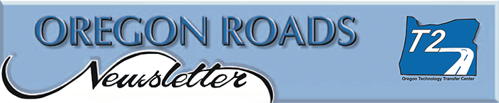
The City of Austin has joined Secretary Foxx's Safer People, Safer Streets challenge, which highlights the ongoing commitment to mobility and safety for all modes of transportation. Road Diet implementations in Austin within the last 5 years have resulted in improved safety for all users with minimal or no impact to motor vehicle level of service.
The Austin Transportation Department (ATD) routinely analyzes the city's streets for opportunities to improve safety and mobility for all road users. ATD's goal is to create safe and complete networks for everyone, and it acknowledges the reality that the large-scale expansion of streets is not financially feasible. ATD makes data-driven decisions about the city's existing roadway assets and uses Road Diets to rebalance underutilized space, improving the efficiency of Austin's streets in the process. Potential Road Diet projects are selected for analysis for a number of different reasons, including the need for improved safety or to provide space for other modes of travel. Austin has selected high-crash locations for these analyses. In addition, Austin citizens or neighborhood associations can request Road Diets in order to improve safety on their neighborhood streets.
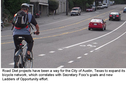
Analyses of the impact of Road Diets involve the study of a "change of operations" at intersections and on arterials as well as changes in crashes and other safety characteristics such as pedestrian and cyclist perceptions of safety. Of the 37 total projects completed in Austin since 1999, 32 were on roads with fewer than 15,000 average daily users. Austin has proven that Road Diets can be used effectively on low-volume roads to improve safety while maintaining mobility.
ATD now regularly includes public involvement and outreach in recognition of the value gained from engaging and gathering input from citizens who use these streets on a daily basis. After implementation of a Road Diet project, ATD observes traffic operations and responds to citizen phone calls and 311 requests to ensure successful implementation. Before and after studies are completed to ensure impacts are realized. Areas of study in Austin include traffic volumes, travel times, peak hour operations, motor vehicle speeds, and crash histories.
The focus of roadway projects during the 1950s and 1960s was on system and capacity expansion, not contraction. Whenever and wherever traffic volumes on a section of road outgrew what a 2-lane road could accommodate efficiently, the next step in roadway design in most cases was to increase the cross-section to 4 lanes. No engineering guidance during that period encouraged consideration of a three-lane alternative.
Consequently, four-lane roadways became the norm throughout the country. Some of these roadways accommodated high traffic volumes requiring four-lane cross-sections, but many accommodated much less traffic for which a smaller cross-section simply had not been considered.
More Information:
The Federal Highway Administration (FHWA) has produced a 72-page information guide that is available for download at http://ruralsafetycenter.org/wp-content/uploads/2015/09/Road_diet_info_guide.pdf
Reprinted with permission of FHWA from their Safety Compass newsletter.
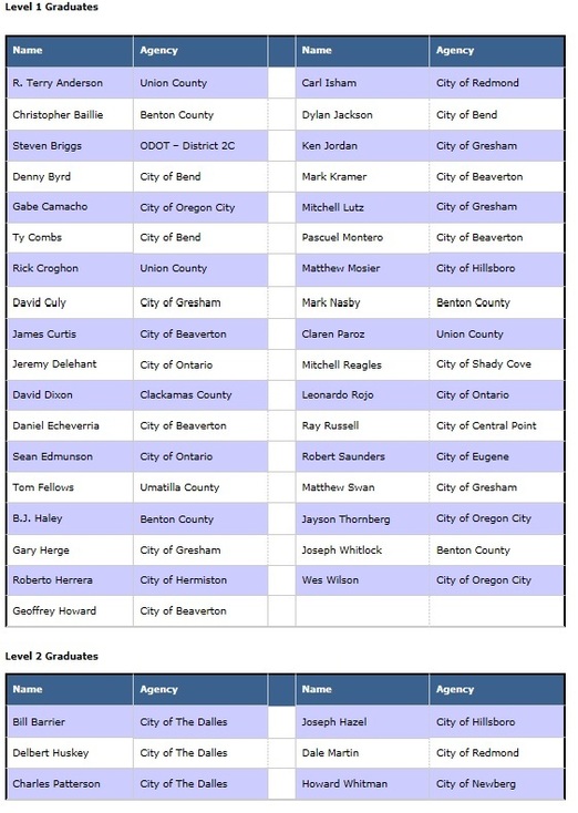
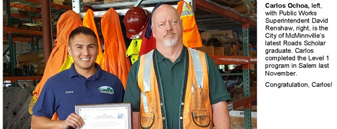
2016 has been a very active year for the T2 Center’s Roads Scholar Program. This spring we held 20 individual classes — mostly on the eastern side of the state. Our flurry of classes has resulted in 35 new Level 1 graduates and six new Level 2 graduates.
We are currently working on scheduling our fall classes. We will be offering the same Level 1 classes (RS-5, RS-6, RS-7, RS-8) that we held this spring, only this time they will be offered for on the western side of the state. In addition, we will be taking RS-12 Workplace Safety Training 2 on the road, bringing this Level 2 class to locations statewide.
If your agency is interested in hosting any of these classes in the September/October/November timeframe, please let us know. It only requires a classroom or meeting room that comfortably seats 40 people at tables. In exchange, the host agency gets to choose the start/stop time of the classes and receives this free training at a convenient, close-to-home location.
Please help us to congratulate the following Roads Scholars on their achievement. Certificates will be mailed to agency contacts in July.
 |

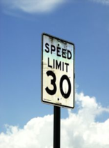 Setting speed zones on Oregon’s highways and streets is often a controversial and emotional issue. Many citizens believe that lowering the speed will improve traffic safety on their street or in their community. On the other hand, speed zones that are unrealistic are often disregarded by a majority of motorists who are normally careful and law-abiding citizens.
Speed zoning, when used with an overall traffic plan, helps traffic move more safely and efficiently. However, it does not provide a quick fix for land-use problems or poor traffic patterns. Instead, speed zoning reflects a reasonable balance between the needs of drivers, pedestrians, and bicyclists using public roads for travel and for those who live along these roads.
The Logic of Speed Zones
Extensive studies from around the US show that traffic moving at a speed that is reasonable for the road and weather conditions results in fewer accidents. Drivers are more patient, because a reasonable, uniform speed allows progress with less passing, less delay, and fewer rear-end collisions. Lowering the speed does not necessarily result in fewer crashes.
The Basic Rule
Designated and posted speeds are not the final word in Oregon, for all travel on public streets and highways is subject to the Basic Rule. The Basic Rule is both a safety valve and an acknowledgement that drivers are able to act independently, reasonably, and with good judgment.
The Rule states that a motorist must drive at a speed that is reasonable and prudent at all times by considering other traffic, road and weather conditions, dangers at intersections, and any other conditions that affect safety and speed.
The Basic Rule does not allow motorists to drive faster than the posted or designated speed. Instead, it expects drivers to be responsible for their own actions.
|
 What Happens When a Speed Zone Change is Requested?
The Oregon Department of Transportation has the responsibility to investigate most public roads at the request of the road authority.
When a city or county asks ODOT to review a speed zone, an engineering study is started. The road is surveyed for the following:
-
Lane and shoulder widths
- Signals and stop signs
- Number of intersections and other accesses
- Roadside development
- Parking and bicycle lanes
Other analysis includes:
- Number and type of vehicles
- Number of pedestrians and cyclists
-
Crash history
- Speed checks
Recognizing that most motorists are generally safe, the speed at or below which 85 percent of the drivers travel is one nationally recognized factor proven by repeated studies as a fair and objective indication of safe and reasonable speeds.
|
 Speed Zoning FAQs
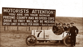
Q: Won’t lowering the posted speed reduce speeds?
A: NO. Studies show that there is little change in the driving speeds after a lower speed sign is posted. Drivers are much more influenced by the roadway conditions and their perceptions of the need to slow down. In fact, the lowering of a speed limit, below what is perceived by drivers as a reasonable speed, may result in greater differences in speeds (more variance) with some going faster and some going slower. This means there are more conflicts between vehicles than before the signed speed was lowered.
One study reduced posted speeds by 5, 10 and 15 mph at numerous sites. When speeds were reduced, less than one-half of a percent of the drivers complied with the posted speeds. The average change in speed for all drivers was less than 2 mph and crashes increased by 5 percent.
Q: How do we get vehicles to slow down?
A: The real question is, “How do we improve safety?” Often, we get so focused on the question of reducing posted speeds that we lose sight of the real reason for slowing drivers. How to improve safety depends on what problem needs to be addressed. Are pedestrians having a hard time finding safe gaps to cross the road? Are vehicles trying to access a highway with high traffic congestion? This is where a local public works department or ODOT can help.
Q: Why do we even have posted speeds?
A: Uniform speeds result in the safest and most efficient operation. The posted speed can keep the traffic flowing smoothly when the majority of drivers find the speeds reasonable. To do this, the speeds must be logical and consistent throughout the state.
If speeds are not reasonable, they can become a source of frustration for drivers when the speeds are enforced, a source of frustration for the local community when the speeds are not adhered to, and a source of frustration for police agencies when they are accused of enforcing the speeds just to produce revenue.
Posted speeds give the motorist an idea of an appropriate speed to drive in unfamiliar locations and are used by enforcement to identify excessive speeds and curb unreasonable behavior.
Q: How are posted speeds determined?
A: The Oregon Revised Statutes sets a default speed for certain streets and roadways. These are referred to as statutory speeds. To set a speed limit not designated in statute, a traffic engineering investigation of the roadway conditions and current speeds must be performed. If that investigation indicates that a lower speed is safe and reasonable, a speed zone order may be issued and a lower speed posted.
Speeds that are posted arbitrarily, without regard to the law, are suspect and could be challenged in court.
Reprinted with permission of Oregon Department of Transportation.
|
Work Zones are responsible for over 130 injuries, one fatality, and 10 percent of all congestion each day. One option for addressing these issues is to implement Smarter Work Zones (SWZs). SWZs utilize innovative strategies to better coordinate construction projects and/or deploy innovative technology applications. They are among a few select initiatives being promoted by the FHWA Every Day Counts 3 (EDC-3) initiative.
Webinar Series
A series of informative webinars began in September, 2015. Slides, transcripts, and audio recordings are available online for most of the webinars already conducted. To date, the following sessions are available:
-
A Comprehensive Overview of the SWZ Initiative
-
Smarter Work Zones and the Work Zone ITS Implementation Guide
-
Smarter Work Zones Corridor-Based Project Coordination
-
Technology Application Showcase: Queue Warning Systems
-
Smarter Work Zone Program-Based Project Coordination
-
SWZ Case Study: Variable Speed Limit and Dynamic Lane Merge
-
Work Zone Project Coordination Guide and Examples
-
Integrating Project Coordination & Technology Applications
-
SWZ Performance Measurement & System Health Monitoring
-
Designing ITS Systems Based on Identified Needs (SWZ ITS Implementation Guide Steps 1-3)
-
SWZ Lane Closure and Permitting Systems
The next webinar is entitled, “Leveraging Traffic Management Center (TMC) and is scheduled for Thursday, June 16, 2016 from 1:00 pm to 2:30 pm Eastern time. Webinar materials and registration are available at: https://www.workzonesafety.org/swz/webinars/.
EDC Exchange for Local and Tribal Agencies
The EDC Exchange is a regularly scheduled series of meetings which combine web-based presentation with in-person group participation. EDC Exchanges describe effective project development and delivery practices, tools, and "market ready" technologies that local and tribal transportation agencies can readily implement into their programs.
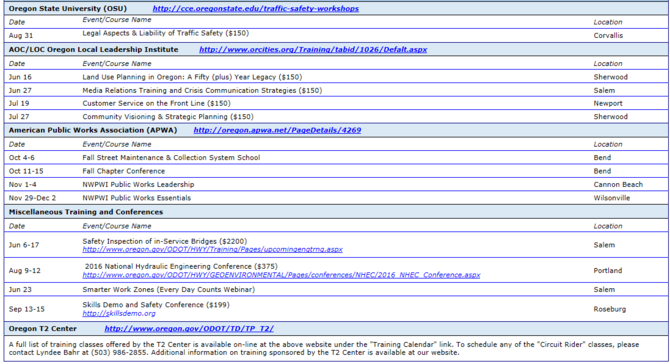
The next EDC Exchange is on Smarter Work Zones and will be held June 23rd from 11:00 am to 1:00 pm Pacific time. The Oregon session will take place at the T2 Center’s office building at 555 13th Street NE in Salem.
This webinar will present success stories from local agencies. It will also include discussions on planning and implementing SWZ within your region.

The Northwest Tribal Technical Assistance Program (NWTTAP) is co-hosting the 28th annual Summer Tribal Planning Institute at Eastern Washington University this summer. Workshops provide a basic knowledge in areas such as transportation, comprehensive planning, Geographical Information Systems, and traffic safety. Join our partners for an exceptional three weeks of learning opportunities presented by accomplished speakers.
Road Life Cycle, June 13-17
Informative workshop includes the process from beginning to end of setting a tribal road.
Tribal Planning, July 11-15
Dynamic workshop will overview the tribal planning history and legal foundations for comprehensive planning and land use.
GIS for Tribal Planning, Transportation and Traffic Safety, August 8-12
Learn basic knowledge of GIS concepts, applications, data driven planning, road maps, and analysis.
Cost is $200 per workshop or $500 for all three.
|
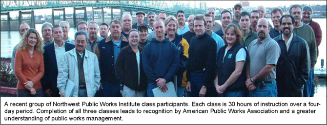
 “What we’re trying to do is build better, more confident managers. I would have loved to have taken a class like this, but it didn’t exist.” Those are the words of John Ostrowski, a semi-retired management consultant who served as Vancouver, Washington’s Public Works Director for 17 years.
Ostrowski helped develop the curriculum for the Northwest Public Works Institute, a series of three 30-hour classes designed to provide a comprehensive view of everything aspiring public works leaders and managers are responsible for knowing. The program is based on a national curriculum outlined by the American Public Works Association (APWA), and completion of the series leads to a certificate of recognition by APWA.
The curriculum is composed of three four-day workshops entitled, “Public Works Essentials,” “The Developing Leader,” and “Public Works Leadership Skills.” Each workshop is offered once annually in Oregon and once in Washington. Residents of either state may participate in sessions held in either location. Sessions are taught by veteran public works professionals, including Ostrowski, and include lectures and numerous group exercises.
Topics covered include:
-
Supervisory skills
-
Basic management skills
-
Communication
-
Leadership skills
- Customer service
- Legal understanding
- Fundamentals of government
- Finance
- Resource management
- Overview of public works operations
- Planning
The series is intended not only for employees aspiring to supervisor and management positions within public works, but also for new and experienced managers and support staff. By providing comprehensive public works leadership training, “you’re going to get better leaders and better productivity,” says Ostrowski.
The Oregon and Washington based NWPWI had its first graduating class in 2007 and since then has graduated over 300 participants, nearly 1/3 of the national total of all public works institutes nationwide. In Oregon, the classes are typically held in March, November, and December. The next class, “Public Works Leadership,” will be held November 1-4 in Cannon Beach. Registration is available at http://oregon.apwa.net/EventDetails/7560.
|
 What Did You Say?
Contributed by Bill Kolzow
Our ears are very delicate tools. They receive sounds from the environment and transmit them through a marvelous system to our brain. But our ears have no built-in protection device, so the intensity and loudness of sounds they receive is “unfiltered” and, if too loud, can cause problems which may lead to hearing loss. This can develop over a period of time, and we may not recognize it happening until it is irreversible.
Occupational hearing loss is the number one cause of non-fatal health problems in the United States. Approximately one-third of hearing loss is avoidable. What causes it? Routine exposure to very loud noise!
- What are your favorite sounds? Could you hear them if you had a hearing loss? Could you have prevented that loss?
- Is your hearing getting worse, or are you just imagining it is?
- Does it seem that many people are mumbling these days?
- Do you find yourself pretending to understand people, when you hardly heard a word they said?
- Do your significant other, your kids or grandkids, your friends complain that you turn the TV or radio volume up too loud?
Maybe you need a hearing evaluation!
Numerous agencies now have hearing conservation programs. But don’t forget that even in our non-work environment, we need to protect our hearing tools: our ears. Use hearing protection everywhere you may be exposed to loud noise. Above 85 dBA, hearing protection is recommended, and above 90 dBA, it is necessary. Many lawnmowers and leaf blowers exceed that level. Don’t take a chance. Be smart.
|
Federal Aid Essentials Videos
http://www.fhwa.dot.gov/federal-aidessentials/indexofvideos.cfm
Nearly one hundred online videos intended specifically for local agencies navigating the Federal aid process. Topic categories include:
- Civil Rights
- Project Development
- Project Construction and Contract Administration
- Federal Aid Program Overview
- Finance
- Right-of-Way (ROW)
- Environment
Safe Practices for Local Roadway Safety
http://www.trb.org/Main/Blurbs/173789.aspx
TRB’s National Cooperative Highway Research Program (NCHRP) Synthesis 486: State Practices for Local Road Safety explores state programs and practices that address local agency road safety. The report focuses on changes in local road safety programs since the legislation of Moving Ahead for Progress in the 21st Century (MAP-21), and the use of Engineering, Enforcement, Education and Emergency Services (4E) approaches to local road safety.
Three-quarters of all road miles in the United States are owned and maintained by local entities. More than half of all fatal crashes occur on rural roads, which are mostly owned by local entities. NCHRP Synthesis 486 documents the state transportation agency programs and practices that address local agency road safety.
The report includes information on state program size, funding sources, and administrative procedures; and noteworthy local/state program partnerships and initiatives to improve safety.
New FHWA Climate Change Adaptation Guide for Transportation Systems Management
http://www.ops.fhwa.dot.gov/publications/fhwahop15026/index.htm
This guide provides information and resources to help transportation management, operations, and maintenance staff incorporate climate change into their planning and ongoing activities. Adjustments to transportation system management and operations (TSMO) and maintenance programs-ranging from minor to major changes-can help to minimize the current and future risks to effective TSMO and maintenance.
Applications for non-infrastructure Safe Routes to School (SRTS) grants are now available for fiscal years ‘17, ‘18, ‘19. Applicants may apply for up to $50,000 per year for up to three years. There is a 12% match requirement. Due date for applications is June 15, 2016.
For more information: http://www.oregon.gov/ODOT/TS/Pages/saferoutes.aspx
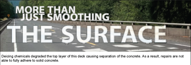 While bridge deck rehabilitation results in smoother road sections, the primary objective is to ensure the deck supports and distributes loads to the structure. Also in combination with the wearing surface, a deck provides a protective cover sealing out moisture and debris.
ODOT maintains over 2,700 bridges and culverts with more than 38,000,000 square feet (sf) of deck. Over time, just like roadways, bridges deteriorate due to weather, studded tires, and heavy loads triggering maintenance needs for wearing surfaces and/or decks. Also, the steel reinforcement in concrete decks is susceptible to corrosion caused by deicing chemicals and marine salt spray.
Q | How do we determine which bridges need a deck project?
A | Bridges are inspected a minimum of every two years to monitor the conditions and to identify any maintenance issues. The inspections include checking all deck elements for distresses, including concrete spalls, exposed steel reinforcement, cracking, corrosion, and other types of deterioration, depending on whether the deck is concrete, steel, or timber.
 The amount of distress and severity, ranging from Good to Warrants Structural Review is recorded. If the distress, is Warrants Structural Review, further steps are taken to ensure that the bridge condition does not pose a safety hazard. As part of the inspection, the Bridge Inspector may identify maintenance recommendations for Region Bridge Crews.
Potential Major Bridge Maintenance (MBM) and rehabilitation projects are also identified using the inspection data by investigating bridges with a significant quantity of elements in poor condition.
Q | What’s involved in deck rehabilitation?
A | Deck rehabilitation can range from simply applying a sealing product to keep moisture out, to a deck overlay with localized repairs, or a complete deck replacement. All projects include equipment mobilization, traffic control, and material costs.
The engineering design balances the need for repair of the bridge with the needs of the traveling public. Sometimes specialized products are required for high traffic areas where an overlay needs to be constructed and the bridge re-opened to traffic within hours.
|
 Q | How important is timing?
A | To prolong the service life of a bridge, major deck work should be done every 20 to 30 years, similar to replacing the roof of a house. The actual driving surface may need more frequent attention.
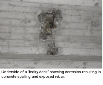
Delaying deck work can lead to accelerated deterioration, triggering an increase in the risk of localized failures that impact traffic and increase deck rehabilitation costs. Extensive delays can result in a “leaky deck,” allowing water to move through to the bridge superstructure resulting in corrosion or other distress, much like a leaky roof letting water into an attic.
Q | Are we keeping up with bridge deck rehabilitation?
A | Assuming a deck requires major rehabilitation about every 30 years, we should rehabilitate about 1,270,000 sf of deck a year (38,000,000 sf deck/30 years). Unfortunately, bridges require other rehabilitation like strengthening, scour protection, crack repair, rail replacement, and joint repairs that may take precedence so only a portion of the Bridge Program budget is spent on decks. Starting from 2013, looking forward to what is programmed -- we are addressing about 270,000 sf of deck a year; about 21% of the need.
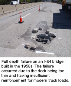
Are we keeping up? No. Fortunately, we are able to keep our bridges in reasonable condition addressing the most critical needs and doing spot repairs. However, as the bridges continue to age, it is inevitable deterioration will continue and most likely accelerate. The Bridge Program is managed as efficiently as possible to keep the bridges in fair condition and to keep them safe and drivable; however, the list of critical needs will continue to increase as the bridge inventory ages. Not being able to address the bridges will lead to rough riding surfaces, increased repair costs, and the need to load post more bridges.
Reprinted from Oregon Department of Transportation Bridge Section’s “Bridge Notes.”
|
Photo 1
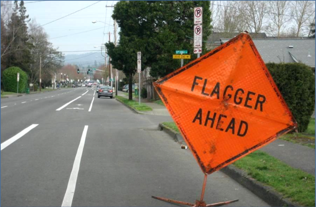 Photo 2
 See Answers Below
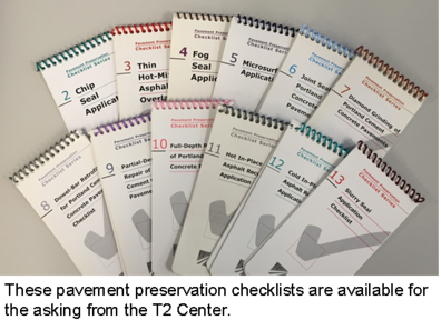 The following Federal Highway Administration (FHWA) checklists are available from the T2 Center while supplies last. To order, call 503-986-2855 or email T2Center@odot.state.or.us.
Checklists are spiral-bound, pocket-sized publications that include preliminary responsibilities, equipment inspections, surface preparation, weather requirements, traffic control, and common problems and solutions for each topic. Topics include:
- Chip Seal Application
- Thin Hot-Mix Asphalt Overlay
- Fog Seal Application
- Microsurfacing Application
- Joint Sealing Portland Cement Concrete Pavements
- Diamond Grinding of Portland Cement Concrete Pavements
- Dowel-Bar Retrofit for Portland Cement Concrete Pavements
- Partial-Depth Repair of Portland Cement Concrete Pavements
- Full-Depth Repair of Portland Cement Concrete Pavements
- Hot In-Place Asphalt Recycling Application
- Cold In-Place Asphalt Recycling Application
- Slurry Seal Application
|
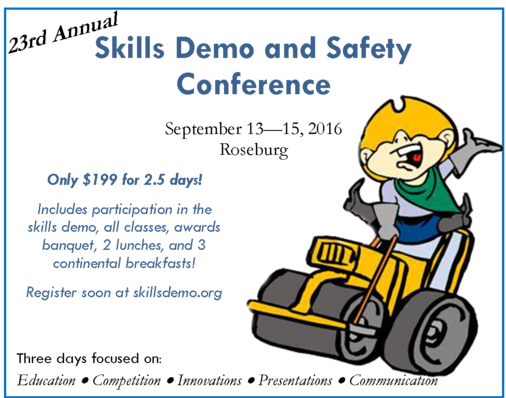
 This year, the annual Skills Demo and Safety Conference will be held at the Douglas County Fairgrounds in Roseburg September 13 through 15. The theme this year revolves around emergency preparedness and response. It also provides an opportunity for road maintenance operators from around the state to compete in equipment operation contests.
The keynote speaker will be Bill Martin with Oregon Office of Emergency Management. Bill worked on the recent multi-state effort to coordinate “Cascadia Rising 2016,” a multi-agency and multi-state exercise to prepare and coordinate response on state, local, and federal levels. His presentation will outline what a major earthquake in Oregon will look like for public agencies and will paint a clear picture of how our public infrastructure might fare in various parts of the state.
Other sessions include the T2 Center’s Emergency Bridge Assessment class, Roads Scholar RS-10 (Introduction to Survey and Grade Checking), Equipment Tie-down, and a presentation by the Disaster Doc, Dr. Sheila Sund.
Dr. Sund is a regular speaker on disaster preparedness topics for healthcare, business, and community groups. Her “disasterdoc” blog is read throughout the world. Her presentation is entitled, “Surviving Cascadia — Are You Ready” and focuses on helping public works employees to develop an action plan now to ensure that their families are prepared for post-disaster survival and to maximize their own safety and well-being while meeting their essential role in community recovery.
An awards banquet will take place on Wednesday evening, where the winners of each skills competition will be announced and prizes will be awarded. Prizes will be awarded for first, second, and third place in the following categories plus “Top Gun” for highest overall score: Pre-trip inspection, Grader operation, Truck plow, Backhoe, Loader, and Chains on/off. Registration will open in June at http://skillsdemo.org.
|
 Local elected officials play a major role in local road safety. They set goals, adopt policies, build coalitions, and approve the budgets for the roads you operate.
These officials, however, typically face many demands for their time and many requests for funding. When you work with them, you need to make every minute count.
COMMUNICATE
Keep it simple
Provide the facts in clear, concise language. Use terms that lay people will understand. Avoid acronyms and engineering jargon— for example, use “federal sign regulations,” not “MUTCD.”
Tell a story
Supplement facts and figures with stories of actual crashes. Explain how your plans may reduce these crashes.
Highlight successful examples
Share success stories from similar communities to show what has been proven to work. Use statistics about effective countermeasures.
Use creative presentation tools
-
Utilize visual aids: photos of a problem site or feature; plans, graphics, or other images of your proposed solutions.
- Consider props: Washington County, MN, for example, created a roundabout “rug” that people can walk on to understand roundabout navigation.
NETWORK
Build and maintain relationships with other safety stakeholders, such as:
-
Elected officials’ staff
- Your state’s department of transportation practitioners
- Law enforcement
- Public health officials
These stakeholders can help you gather safety information and reinforce support for safety initiatives when you communicate with your elected officials.
KNOW THE FACTS
Have the facts at hand about road safety in your community. You are the roadway expert, and the elected official looks to you for guidance:
- Know the problem locations, crash data, causes, and citizen concerns.
- Know State and Federal funding options and relevant safety policies.
- Know potential safety strategies and countermeasures to address issues.
INFORM AND EDUCATE
Inform and educate your elected officials:
- Present your data, proposed solutions, and costs.
- Scale your proposed solutions to a level your officials are able to address.
- Educate listeners about proven, effective, low-cost solutions.
-
Anticipate opposing views, and prepare responses to address them.
- Prepare a one-page summary of your main points.
|
 Contributed by Michael Swan
Safety, like many things in our lives and careers, is frequently about choices – and we all have a role in making the choices that affect traffic safety. Managers and administrators have responsibilities for creating policy and we all share in contributing to and implementing those policies.
One of the first steps in addressing safety issues is identifying them. We receive information through many channels. Citizen complaints are not the only source. All of our workers can, and should, contribute as well. A maintenance crew pulling shoulders or ditches may see tire tracks running off the road and may notice that this happens repeatedly in a particular area. Sharing that information with management may alert them to a problem.
Once a safety problem is identified, the causes need to be found. Sometimes this is easy, but sometimes the causes are complicated and many factors may contribute. Understanding the causes frequently points to a solution. Unfortunately, it is unlikely any agency will have the funding to address every safety issue, much less the ability to deal with each of them immediately. Prioritizing the safety issues and their solutions is important. It allows an agency to spend its limited funds in an organized manner and can help the public understand why the choices were made. Additionally, having a plan may provide some protection in the unfortunate event of a lawsuit.
Michael Swan, ODOT’s Safety Circuit Rider, can provide help to identify problems and their causes. Additionally, he can provide technical assistance in finding solutions.
Choose safety and choose safely. Share what you see. We will all benefit.
|
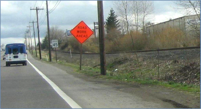
One of several basic work zone safety principles is “Driver Believability.” We always want drivers to believe the actions we’re asking them to take and/or the information we’re providing them is necessary. Our goal is to have the typical driver give us some attention; watch out for us in our work zone. If our signs are not meaningful, those same drivers may become lax in attention when they approach the next work zone. This can possibly contribute to a work zone accident.
Photo 1 shows a FLAGGER AHEAD sign on a main route through a city. (Although not shown, this sign was also preceded by a BE PREPARED TO STOP sign.) Looking beyond the sign, there is no flagger present, and no indications (cones or other channelizing devices) of any work zone within a reasonable distance of the flagger sign. It would appear someone forgot to remove the sign.
Photo 2 shows a ROAD WORK AHEAD sign, required for a long-term project. However, this sign has been in place for numerous years, and there has been no road work along that portion of highway for years. The sign is meaningless and misinforming. It is doubtful that any habitual user of this road evens notices the sign anymore. What happens when they approach/see another of these signs and that sign really does mean what it says; someone is working ahead? Driver believability and the added attention we seek for our work zones may not be there.
Turn, cover, or remove unnecessary signing.
|