|
Avoid the personal hardship and economic distress caused by flood disasters by purchasing low-cost flood insurance to protect your home and possessions. For information, call the Oklahoma Water Resources Board 405-530-8800 or your insurance agent.
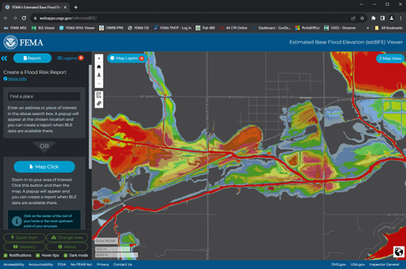 Screenshot of the FEMA BLE website to be used as an example for others.
When areas have been designated as Special Flood Hazard Areas on the community’s Flood Hazard Boundary Map (FHBM) or Flood Insurance Rate Map (FIRM) and no Base Flood Elevations (BFE) or an identified floodway have been developed, communities are required to apply the provisions of 44 Code of Federal Regulations (CFR) 60.3 (b) (4). This requires that communities:
Obtain, review and reasonably utilize any base flood elevation and floodway data available from a federal, state or any other sources.
Data obtained is to be used by communities as criteria for requiring that new construction and substantial improvements have their lowest floors elevated to or above BFE (nonresidential structures can also be floodproofed to or above the BFE) and for prohibiting any encroachments in a floodway that could result in any increase in flood levels during occurrence of the flood discharge.
The data obtained should be used as long as it reasonably reflects flooding conditions expected during the base flood, are not known to be scientifically or technically incorrect, and represent the best data available. Two such methods are outlined below.
Zone A Floodplains and Base Level Engineering (BLE). More than half of flood zones shown on Flood Insurance Rate Maps (FIRMs) are designated as Zone A – depicting areas that are potentially flood prone during larger rain events with a shaded polygon, but not providing a published Base Flood Elevation (BFE) to assist local communities review of proposed development.
While BLE flood information does not replace data shown on your community’s current FIRM panels, the data complements current FIRM Zone A areas and provides additional coverage where streams have not yet been included in the FIRM data coverage, expanding the coverage of available data for community and industry use.
How does Base Level Engineering (BLE) assist local development review? BLE and the Estimated Base Flood Elevation (EstBFE) Viewer provide a free interactive on-line portal to allow communities to identify site specific Base Flood Elevations and download engineering models that can be used by the development industry to assess the change in flood prone areas prior to the start of construction activity. Users can look up Base Flood Elevations and flood depths with an address entry. A free report tool is available for printing, allowing residents to coordinate with community officials prior to any renovation, restoration or recovery efforts.
For more information and to check for availability of Base Level Engineering information in your vicinity at: https://webapps.usgs.gov/infrm/estBFE/ and https://www.fema.gov/sites/default/files/documents/fema_when-use-ble.pdf
Preliminary map data. Data from a draft or preliminary Flood Insurance Study (FIS) constitute available data under 44 CFR 60.3 (b) (4). Floodplain Management Bulletin 1-98 provides guidance on the use of FEMA draft or preliminary Flood Insurance Study data as best available. data for regulating floodplain development. Copies of Floodplain Management Bulletin 1-98 can be found online.
Driving through moving floodwaters is one of the most common causes of accidental death and injury during a rainstorm or flood event, according to Yohanes Sugeng, chief of the OWRB’s Engineering & Planning Division.
Sugeng points out that cars may be easily moved by deceptively powerful floodwaters. And although it may seem shallow, the depth of water on a flooded road’s surface may be as deep as 18 to 24 inches—enough to cause a vehicle to float.
“People often get a false sense of security while in their car during severe storms,” he explains. “But driving through rapidly moving water—even as shallow as one foot deep—can pose a serious risk to the occupants of even the largest vehicle.”
An automobile driven straight through a stream of water two feet deep will have about 18 square feet of car surface impacted by the water’s flow. If the water is moving at 15 miles per hour, the side of the car will be hit by more than 25,000 pounds of water every second.
If conditions seem safe and floodwaters are receding, the motorist should still proceed with caution—driving slowly through low-water areas.
For more information about Floodplain Management visit the OWRB's Floodplain Management website or contact us.
|