|
Town Supervisor Joseph D. Cavaccini has declared a State of Emergency, ensuring Town of Wappinger resources are best prepared as heavy snowfall is expected Sunday morning into Monday, creating potentially hazardous conditions.
Following meetings with the Dutchess County Department of Emergency Response and Town personnel, Town Supervisor Joseph D. Cavaccini has provided the following updates for our community to be best prepared this weekend.
❄️CODE BLUE protocol remains in effect for anyone who needs shelter when temperatures are 32 degrees or below. Call 211 or visit https://www.dutchessny.gov/Departments/Community-Family-Services/code-blue.htm ❄️
❄️🚨
Wintertime Parking Ordinance to take effect 5:00 am Sunday until 5:00pm Monday.
🚨❄️
❄️ MAJOR SNOWSTORM ALERT ❄️
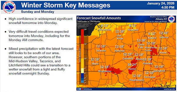
A significant snowstorm is expected Sunday into Monday, with totals of up to 18”.
The Dutchess County Sheriff’s Office will continue to enforce the ordinance during the next round of snow coming our way. Please make sure items such as garbage bins and basketball hoops are kept off of roadways.
Yesterday, Wappinger Town Highway Department and Dutchess County DPW crews have presalted roads in advance of the cold temperatures we will begin receiving tonight.
Plowing will create large snow piles at the ends of driveways — everyone gets their share.
Please do NOT plow, shovel, or blow snow into the street. This creates dangerous conditions and slows cleanup.
Due to the size of the storm, snow removal will continue into Monday evening, and additional snow piles at driveway entrances should be expected as crews widen and clean up roads.
What does a “State of Emergency Declaration” mean? Chief Executive Officials will declare these Executive Orders to allow for a more efficient snow removal process and access resources for the Town government.
Town Supervisor Joseph D. Cavaccini and Superintendent of Highways Michael J. Sheehan will be on scene together as crews respond to the storm.
Please stay safe, stay warm, and enjoy your snow day, Wappinger!
DUTCHESS COUNTY
DEPARTMENT OF EMERGENCY RESPONSE
EMERGENCY MANAGEMENT
(845) 486-2080
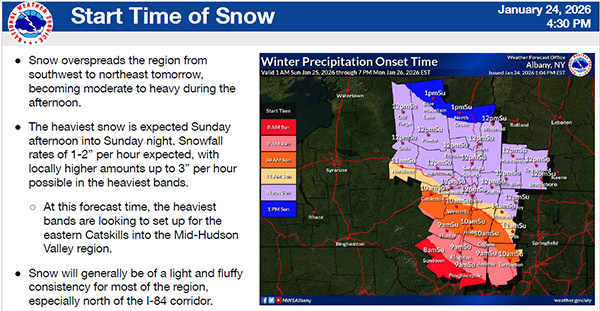
WINTER STORM WARNING
Based on the latest information obtained through
communication with the National Weather Service
COLD WEATHER ADVISORY - FRIDAY 7pm until SATURDAY 10am
WINTER STORM WARNING - SUNDAY 7am until MONDAY 7pm
Saturday Night
Mostly cloudy, with a low around 4. Chance of precipitation is 20%.
Sunday
Snow mainly after 9am. Snow will be heavy at times. High near 16. Chance of precipitation is 100%.
Snow accumulation expectations range from 8-12 inches.
Sunday Night
Snow. Snow will be heavy at times. Low around 14. Chance of precipitation is 100%.
Additional snow accumulation expectations range from 4-8inches.
Monday
Snow, mainly before 1pm. New snow accumulation of less than an inch. High near 26. Chance of precipitation is 80%.
Total snow accumulation expectations range from 12-18 inches and 18-24 inches in higher elevations.
|