This bulletin provides only the most recent notices. Check the Adirondack Backcountry webpages for more detailed information on access, outdoor recreation infrastructure, and conditions.
Emergency Situations: If you get lost or injured; keep calm and stay put. If you have cell service, call 911 or the DEC Forest Ranger Emergency Dispatch, 833-NYS-RANGERS.
Welcome to the Adirondacks. The Welcome to the Adirondacks webpage provides information about the Forest Preserve, conservation easement lands, outdoor recreation, and Leave No Trace™.
Love Our New York Lands: All New Yorkers and visitors should be able to access, enjoy, and feel welcome on state lands. While enjoying these shared spaces, be respectful of other visitors. Share trails, treat people with kindness, and leave things as you found them for others to enjoy. All of us have a responsibility to protect state lands for future generations. Learn more about how you can Love Our New York Lands.
In this issue:
The following are only the most recent notices pertaining to public lands in the Adirondacks. Please check the Adirondack Backcountry webpages for a full list of notices, including seasonal road statuses, rock climbing closures, specific trail conditions, and other pertinent information.
Follow @NYSDECAlerts on X for updates about DEC-managed lands across New York State! The @NYSDECAlerts X feed provides real-time info on the most crowded places, especially when those places and parking areas are at capacity.
NEW THIS WEEK
-
Vanderwhacker Mountain Wild Forest Bridge Reopening: The Moose Pond Club Road Bridge was recently replaced and reopened, allowing direct public access to Moose Pond Club Road, several primitive campsites, and the trail to the Vanderwhacker Mountain Fire Tower.
If you notice any damage or hazardous areas not listed below, please report to info.r5@dec.ny.gov.
LAST WEEK
Northwestern
-
Grass River Wild Forest Closures: The 24.6-mile section of the St. Lawrence County Multi-Use Trail that crosses the Tooley Pond, Grass River, and Long Pond Conservation Easements closed for the season on Sunday, September 15th. AND As of Monday, September 2nd, all public non-motorized access on trails, roads, and overland on the Cranberry Forest Conservation Easement is closed for the season. This excludes the Year-Round Public Access Area surrounding Dillon Pond.
East Central
-
Jessup River Wild Forest Fire Tower Debris: Pillsbury Mountain Fire Tower Observer’s Cabin had one of the walls collapse. Debris from the wall has fallen into the trail leading to the fire tower. Hikers coming to visit the tower should be cautious of nails and broken remnants of the wall and try to walk on the boards that have been placed down. DEC staff will work to clean up the debris.
Eastern
-
Lake George Wild Forest Bridge Removal: The bridge at the outlet of Shelving Rock Brook in the Day Use Area, near Shelving Rock Bay, has been removed due to unsafe conditions. Hikers should be prepared to ford the stream, or use the trails from parking lots 5 and 8 to reach the day use area and shoreline.
-
Lake George Wild Forest Trail Closure: The Northwest Bay Trail is closed from the intersection of Fivemile Point Trail to Montcalm Point. The trail is impassible due to significant blowdown from storm damage.
-
Pharaoh Lake Wilderness Bridge Removal: The Mill Brook bog bridge has been removed due to its deteriorating condition. The Pharaoh Lake Trail remains open. Users should expect wet conditions when crossing. Hikers can use the DECinfo Locator online map to explore alternative trails to reach Pharaoh Lake.
Southwestern
-
Independence River Wild Forest Washouts: Smith Road has multiple washouts – repairs are ongoing and the road will be opened further to the south as repair work is completed.
-
Independence River Wild Forest Trail Closure: Eatonville Trail is currently closed due to ongoing work on power lines which the trail crosses.
Southern
-
Ferris Lake Wild Forest Storm Damage: DeBraine-Trout Lake Trail has significant storm damage starting at DeBraine Lake and going towards Trout Lake. Hikers will encounter a large area of wind-thrown and tangled trees. Navigating to Trout Lake will be difficult. DEC staff has flagged a route around the worst areas and will work to remove the blowdown and restore trail conditions.
Public Health Notice: Eastern Equine Encephalitis (EEE)
Eastern equine encephalitis (EEE) is a rare but severe viral disease detected in New York that can affect people and spreads by infected mosquitoes. New Yorkers should use insect repellant when outdoors and take steps to prevent mosquitoes around your home. Read the full press release. For more information about EEE, go to the Department of Health’s website.
Fire Danger: Check the fire rating map for daily updates.
Sunrise/Sunset: Sunrise = 6:47 a.m.; Sunset = 6:47 p.m. Pack at least one headlamp (two headlamps recommended) even if you expect to finish your activity before sunset. Phone batteries drain quickly and are discouraged.
Water Crossings: Water levels are average to slightly low for this time of year in the Adirondack region. Expect water levels to rise with new rainfall. Check the USGS Current Water Data for New York for stream flow of selected waters. (Personal Flotation Devices (PFDs aka lifejackets) are strongly recommended if spending time on the water.)
Temperatures: These are forecast temperatures for base elevations throughout the region.
Weekend temperatures in the region are expected to produce highs in the mid-60s and lows in the mid-40s. It will be fairly sunny throughout the weekend with calm and variable winds.
Check the National Weather Service’s Mountain Point Forecast for more accurate forecasts at elevation on or near your intended route.
Reminder: These forecasts are for low elevations. Anticipate losing 5 degrees Fahrenheit for every 1,000 feet of elevation gain.
Even with sunny skies, inclement weather is always a possibility and can change very quickly. Remember – hypothermia is always a risk in wet conditions, even when it feels warm outside. Be prepared with extra dry layers and keep an eye on the weather.
Conditions: It will be another beautiful weekend for outdoor recreation as we near peak fall foliage! It should be sunnier and with calmer winds than last weekend, but chillier daytime temperatures. Just remember, it can be chilly at high-elevations, especially above tree line or on bald summits where wind and elevation can drop the temperature dozens of degrees compared to the trailhead. You may opt to wear shorts to start your hike, but pack long pants, layers, and even hats/gloves for the summit. Dustings of snow on summit tops is not unlikely this time of year.
Check the Weather: Check the forecast for your destination and pack and plan accordingly. Check the National Weather Service Northern Adirondacks and Southern Adirondacks Mountain Point Forecasts for select summit forecasts. Check both daytime and nighttime temperatures and remember that temperatures will drop as you gain elevation.
Check the Air Quality Index (AQI) Forecast: If the AQI is forecast to exceed 100, DEC and the New York State Department of Health (DOH) will issue an Air Quality Health Advisory with precautionary recommendations for affected areas. View DEC’s current AQI forecasts and real-time air pollution data from DEC’s monitoring network.
Visit the main Adirondack Backcountry page for more trip-planning resources.
Seasonal Road Closures: See DEC’s Adirondack Backcountry Information page for specific road conditions and information.
Adirondack Mountain Reserve: From May 1 through Oct. 31 (2024), reservations are required to access the parking lot, trailheads, and trails located on the privately owned 7,000-acre AMR property in the town of Keene in the Adirondack High Peaks region. For a list of frequently asked questions, visit AMR's website
The Town of Keene’s Hiker Shuttle: (*Operated by the Town of Keene.) Since July 6, hikers can park at Marcy Field (in the Town of Keene) and ride the shuttle to the Garden trailhead on Saturdays from 7 a.m.-7 p.m. through the weekend of October 12. The fee is $10, cash only, per person for a round trip.
Mount Colden Trapdike: The trapdike is considered a technical climb and not a hike. Climbers should be prepared with helmets, ropes, and climbing gear to ascend this route. Hikers looking to summit Mount Colden should do so via the hiking routes. Attempting to climb the trapdike unprepared can result in a rescue operation, serious injury, or death.
Bear Canisters Required: NYSDEC requires the use of bear-resistant canisters by overnight users in the Eastern High Peaks Wilderness between April 1 and November 30. NYSDEC encourages campers to use bear-resistant canisters throughout the Adirondack backcountry. Bear canisters should be used to store all food, food garbage, toiletries, and other items with a scent. Canisters should be stored a minimum of 100ft from tents, lean-tos and cooking sites and kept closed whenever they are not being accessed. Learn more about bear canisters and avoiding human-bear conflicts.
No Overnight Camping at Trailheads: Overnight camping is not permitted at trailheads or other roadside locations where a camping disc is not present. This includes individuals sleeping in cars, vans, and campers. Campers should seek out designated roadside campsites marked with a "Camp Here" disc or open campgrounds. When camping, always carry out what you carry in and dispose of trash properly. Use designated bathroom facilities, pack out human and pet waste, or dig a cat hole.
Travel: Plan on arriving at your destination early and have several back-up plans in place in case parking at your desired location is full. Check recent notices for road closure announcements.
Ticks: This is an active time of year for ticks – and yes, we do have ticks in the Adirondacks! Wear light-colored clothing with a tight weave to spot ticks easily. Wear enclosed shoes, long pants and a long-sleeved shirt. Tuck pant legs into socks or boots and shirt into pants. Check clothes and any exposed skin frequently for ticks while outdoors. Consider using insect repellent. Stay on cleared, well-traveled trails and walk in the center of trails. Avoid dense woods and bushy areas. Additional tips for tick prevention.
Summits have intensely beautiful views, and intense weather to go along with them! This time of year, it’s critical to be prepared for all ends of the intense weather spectrum by bringing sun protection AND protection from the cold in the form of gloves/hat/etc.
You may know that temperatures drop as you go higher up a mountain (approximately 5 degrees Fahrenheit for every 1,000 feet of elevation gain), even though you’re getting closer to the sun. This is due to air pressure changes. “Heat rises” doesn’t apply when hiking, because heat can move in any direction depending on the situation.
However, on a sunny day, you may feel warmer at the summit simply due to increased solar radiation, especially if you’re just emerging from being shaded by the trees. On the other hand, if it’s windy on a wide-open summit, you may feel much, much colder.
This is the time of year where how it’ll feel on top of the mountain is really—no pun intended—up in the air! Stay prepared for it all!
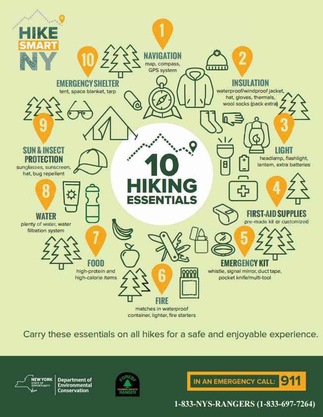
Whether you are hiking, mountain biking, or paddling, Hike Smart NY can help you prepare with a list of 10 essentials, guidance on what to wear, and tips for planning your trip with safety and sustainability in mind.
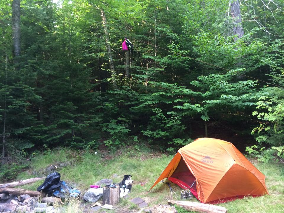
Ah, fall. What a great time for camping! The weather is refreshingly crisp, not so cold (usually) that you’re freezing at night, but still cool enough to cozy up by a campfire. And you have beautiful foliage surrounding you.
Whether you’re primitive camping (designated sites and lean-tos can be found on DECinfo Locator), or seeking more amenities (you can reserve a spot at a campground through Camping & Campground Reservations Online | ReserveAmerica, although some closed earlier this month), it’s always important to Leave No TraceTM.
Principle 2 of Leave No TraceTM: “Travel and Camp on Durable Surfaces,” is especially pertinent when you’re primitive camping. And it’s extra important if you’re choosing not to stay at a designated campsite or lean-to. The best campsites are found, not made, but if you’re not using a designated site, your tent must be at least 150 feet from a water body, road, or trail.
However or wherever you’re camping, remember the following tips to Leave No TraceTM!
In popular areas:
- Walk single file in the middle of the trail, even if wet or muddy.
- Keep campsites small.
In undisturbed areas:
- Avoid places where impacts have begun by opting for lesser-used areas.
- Disperse to prevent erosion.
- Erosion in one spot can eventually cause it to look like an established campsite. You’ll know it’s not though if it doesn’t show up on the DECinfo Locator map as one, or if there’s no “Camp Here” signage.
Durable, ideal surfaces include established campsites, rock, gravel, dry grasses or snow, and areas where vegetation is absent. Also, remember to respect wildlife by keeping your distance during this sensitive time as they prepare for the winter!
Follow the Seven Principles of Leave No TraceTM to maintain minimal impact on the environment and the natural resources of the Adirondacks.
|