
DEC Adirondack Outdoor Recreation Bulletin - March 24, 2022
The New York State Department of Environmental Conservation sent this bulletin on 03/24/2022 03:53 PM EDT |
| DEC Delivers - Information to keep you connected and informed from the NYS Department of Environmental Conservation |
| Share or view as a web page || Update preferences or unsubscribe |
DEC Adirondack Outdoor Recreation BulletinMarch 24, 2022 |
|
This bulletin provides only the most recent notices. Check the Adirondack Backcountry Information webpages for more detailed information on access, outdoor recreation infrastructure, and conditions. Emergency Situations: If you get lost or injured; keep calm and stay put. If you have cell service, call 911 or the DEC Forest Ranger Emergency Dispatch, 833-NYS-RANGERS. Welcome to the Adirondacks. The Welcome to the Adirondacks webpage is the place to go if you are interested in learning more about the Adirondacks. It provides information about the Forest Preserve, conservation easement lands, outdoor recreation, and Leave No Trace. Love Our NY Lands: All New Yorkers and visitors should be able to access, enjoy, and feel welcome on state lands. These lands belong to all of us, our families, and our neighbors. While enjoying these shared spaces, be respectful of other visitors. Share trails, treat people with kindness, and leave things as you found them for others to enjoy. All of us have a responsibility to protect State lands for future generations. Learn more about how you can Love Our NY Lands. Recreation Highlight: DEC Advises of Avalanche Risk in AdirondacksDEC advises backcountry users in the Adirondacks, especially the High Peaks region, of potential avalanche risk following mild temperatures and high winds. Avalanche danger increases during thaws when warmer weather and rain melt existing snowpack and snow becomes increasingly unstable as it undergoes freeze/thaw cycles. How to Minimize Risk: Individuals headed outdoors can reliably avoid avalanches by recognizing and avoiding Risk cannot be entirely eliminated if traversing avalanche terrain, but risk can be minimized by using techniques: climb, descend, or cross avalanche areas one at a time; cross a slope at the very top or bottom if possible; climb or descend the edge of a slope rather than the center; carry and know how to use avalanche rescue gear; and turn back or alter the route if signs of unstable snow are detected. Signs of Danger: When the snow cover is very unstable, nature often broadcasts clear danger signals. Fresh avalanches are the best clue. Snow that cracks, collapses, or makes hollow sounds is unstable. Weak layers that are found by digging snow pits are signs of unstable snow. Snow that has become wet from thaw or rain can be dangerous. Even if no signs of unstable snow are found, individuals should always travel observing the techniques listed above to minimize risk. Be Prepared: Outdoor adventurers should always have an avalanche transceiver (or beacon), shovel, and a collapsible or ski-pole probe during avalanche conditions and should practice frequently to be proficient in using a beacon. However, visitors should not take extra risk just because rescue equipment is available to be used and should always carry a day pack with enough equipment to spend the night. Recent NoticesThe following are the most recent notices pertaining to public lands in the Adirondacks. Please check the Adirondack Backcountry Information webpages for comprehensive and up-to-date information on seasonal road statuses, rock climbing closures, specific trail conditions, and other pertinent information. New: High Peaks Wilderness:
Saranac Lakes Wild Forest: All snowmobile trails are closed. Debar Mountain Wild Forest: All snowmobile trails are closed. Wilmington Wild Forest: The Wilmington Snowmobile Trail is now closed. Sargent Ponds Wild Forest: All snowmobile trails are closed. Lake George Wild Forest:
Adirondack Rail Trail: The trail is now closed to snowmobile use for the season. Region 6 is closing all mud gates to snowmobile trails and seasonal access roads on Forest Preserve, State Forest, and Conservation Easement lands due to spring thaw and muddy conditions. Kushaqua and Sable Highlands Easements: Mud locks will be in place by April 1st to protect the integrity of the roads until further notice. Watson's East Triangle Wild Forest (Croghan & Oswegatchie Conservation Easement Tracts): All mud gates in Watson’s East Triangle Wild Forest as well as those on the Croghan Tract and Oswegatchie Conservation Easement will be shut starting the week of 3/21/2022. Roads will be reopened when they are dry and firm enough to support motor vehicle traffic. Independence River Wild Forest (Stillwater Reservoir, Big Moose & Three Lakes Conservation Easement Tracts): DEC staff will begin shutting mud gates in the Independence River Wild Forest the week of 3/28/2022. Roads will be reopened when they are dry and firm enough to support motor vehicle traffic. All snowmobile gates on Macomb State Forest, Taylor Pond Campground, and Taylor Pond Wild Forest have been closed for the season. Ferris Lake Wild Forest: Powley Road is closed for mud season until further notice. Moose River Plains Wild Forest:
Silver Lake Wilderness: West River Rd. that provides access to Whitehouse/Northville Placid Trail is closed for mud season until further notice. All snowmobile trails in the town of Newcomb are closed (C8A & C7B) Essex Chain Lakes: All mud gates are closed. Vanderwhacker Mountain Wild Forest: The Campsite Road gate is closed for mud season Last Week: Corinth Edinburg Conservation Easement: Snowmobile trails in the western Saratoga County area are now closed. (Saratoga Snowmobile Club) Speculator Tree Farm Perkins Clearing Conservation Easement, Jessup River Wild Forest: Snowmobile trails in the Speculator region are closed as of Saturday, March 19. General Notices
Visit the main Adirondack Backcountry Information page for more trip-planning resources, including travel information, weather resources, and seasonally-specific information about Adirondack recreation. Hike Smart NY can help you prepare with a list of 10 essentials, guidance on what to wear, and tips for planning your trip with safety and sustainability in mind Check the Weather: Check the forecast for your destination and pack and plan accordingly. Check the National Weather Service Northern Adirondacks and Southern Adirondacks Mountain Point Forecasts for select summit forecasts. Check both daytime and nighttime temperatures and remember that temperatures will drop as you gain elevation. Check wind chill temperatures and prepare for colder, windier summits. Spring Conditions: Be prepared for a mix of winter and spring conditions. Snow and ice are still present throughout the region, but warmer temps have brought high waters and muddy trails in low elevations. Be prepared with warm, waterproof layers, extra layers, and proper gear for snow and ice, including snowshoes, microspikes and crampons. In the High Peaks Wilderness, snowshoes or skis are still required to be worn where snow depths exceed 8 inches. Remember that conditions will change as you gain elevation, and cold, wet weather poses a significant risk of hypothermia. Avalanche Advisory: Backcountry downhill skiers, snowboarders, and all outdoor adventurers who may traverse slides or steep, open terrain should be aware of and prepared for avalanche conditions. If you are planning a trip to avalanche-prone territory, research the route ahead of time and contact a local DEC Forest Ranger for specific safety and conditions information, or contact a local guide. Before going into the backcountry, be equipped with avalanche safety tools and knowledge, such as participation in an avalanche safety course. Additional information on avalanche danger, preparedness, and safety precautions is available on DEC's website. Muddy Trails & Monorails: As snow begins to melt on lower elevation trails, be prepared for mud and monorails. Monorails are thin strips of hardpacked snow and ice in the center of trails, surrounded by minimal or no snow on the sides. Monorails can create difficult walking conditions. Microspikes and trekking poles can assist with traction and balance. Where trails are muddy, walk directly through mud instead of around it to help minimize trail widening and trailside damage. Seasonal Roads: Some seasonal access roads are beginning to close for spring mud season, while others are still open for snowmobile use only. Where seasonal access roads are open to public motor vehicles, the use of four-wheel drive vehicles is strongly recommended. Snowmobiles: Be prepared for variable conditions. Visitors are advised to plan ahead and check local club, county, and state webpages and resources, including the NYSSA Snowmobile web map, for up-to-date snowmobile trail information. Pack & Prepare: Winter hikes can be lots of fun, but they can also be dangerous if you're not prepared. Take a moment to watch DEC’s How To Pack and Prepare for a Winter Hike video for a review of what gear to pack and the steps to take as you plan your hike. Layer Up: Temperatures can change significantly depending on your location, the time of day and your elevation. Stay safe and warm by wearing non-cotton, moisture-wicking base layers, insulating layers, and waterproof, windproof outer layers. Wear a hat, mittens or gloves, and a buff. Gaiters can help keep your lower legs warm and prevent snow from getting in your boots. Bring additional layers. Wear sturdy waterproof boots that are already broken in. Learn more about layering for cold weather by watching DEC’s How To video. Share the Trails: Many multi-use trails are enjoyed by a variety of users in the winter. Be respectful of everyone’s experience by following winter trail etiquette. Wear snowshoes to prevent postholing and keep ski and snowshoe tracks separate when possible. Move to the right to let faster users pass and yield to downhill traffic. When stopping, step to the side of the trail to make way for other users. Snowmobiles should ride single file, keep to the right, pass on the left only when the trail is clear, and yield the right-of-way to skiers, snowshoers and other non-mechanized forms of travel as well as those passing or traveling uphill. Leave No Trace
Follow the Seven Principles of Leave No Trace to maintain minimal impact on the environment and the natural resources of the Adirondacks. Use proper trail etiquette to ensure an enjoyable experience for yourself and others and tread lightly! Encourage and Inspire Leave No Trace in Social Media Posts. Given the millions of social media users in the world, think of the incredible potential that social media has to provide critical Leave No Trace education and information to people getting outside to care for the natural world. Invite people into the conversation, welcome them to the outdoors, and try not to make assumptions about their background or intentions:
|
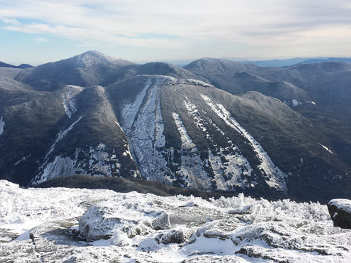 avalanche terrain. Travel on the valley floor away from large avalanche runouts, along ridgetops above avalanche paths, in dense timber, or on slopes of 25 degrees or less that do not have steeper slopes above them. Avoid cornices, or hanging masses of hardened snow.
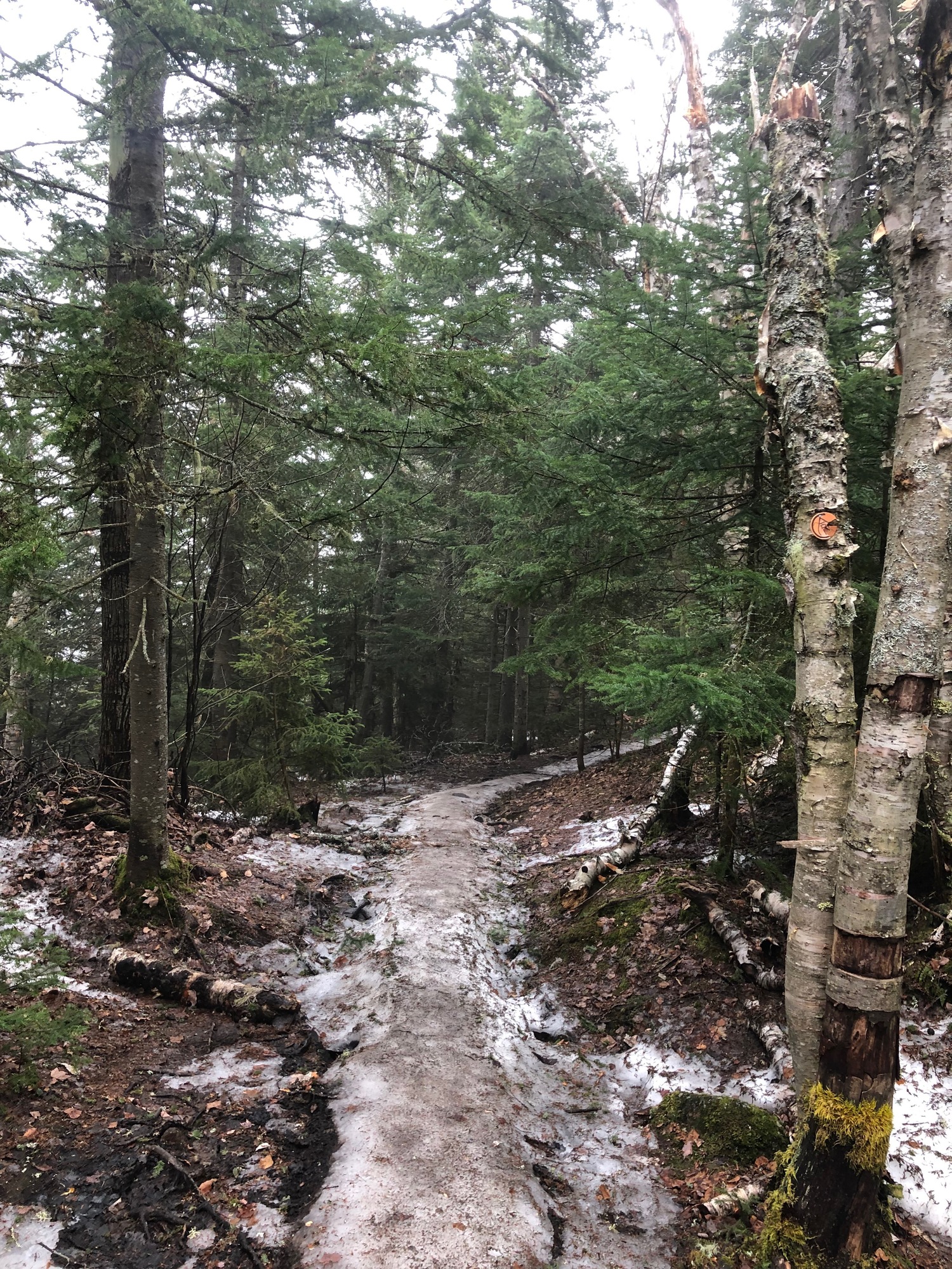
|
The New York State Department of Environmental Conservation respects your right to privacy and welcomes your feedback | Update preferences or unsubscribe | Learn more about DEC Delivers |
|
| Connect with DEC: |
|
| Basil Seggos, Commissioner | |