
Drinking Water Source Protection Program (DWSP2) - October Newsletter
The New York State Department of Environmental Conservation sent this bulletin on 10/15/2021 02:55 PM EDT |
| DEC Delivers - Information to keep you connected and informed from the NYS Department of Environmental Conservation |
| Share or view as a web page || Update preferences or unsubscribe |
Drinking Water Source Protection Program - October NewsletterThis issue's topics:
|
Technical Assistance Providers Available to Protect Your Drinking Water!Have you been asking yourselves; how can I work with this program to protect my drinking water? Good news! The State is looking for communities interested in working with a technical assistance provider (TA provider) to develop and implement a DWSP2 plan for their source of drinking water.
If you would like to work with a TA provider, head over to the DWSP2 webpage and complete an application. Once completed, submit the application by using the submit button at the bottom of the PDF. If anyone has any questions, reach out to the DWSP2 Team at source.water@dec.ny.gov.
What can I expect?As a reminder, TA providers work with the community every step of the way, using the DWSP2 Framework, to develop a DWSP2 Plan specific to their community and drinking water source. TA providers will:
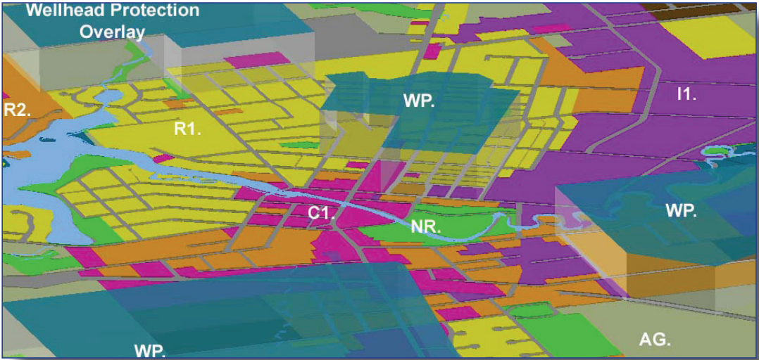
Overlay District and Source Water ProtectionWhat is an Overlay District?An overlay district is a special zoning area placed over the “base” zoning district(s) for the purpose of protecting a resource such as a waterbody or historic area, addressing a special problem, or to guide development within a special area.
The overlay district essentially adds a layer of safeguards, standards or incentives that is above & beyond what has been established for the base zoning uses. The base zoning requirements still apply but overlay district standards apply in cases where the base and overlay requirements conflict.
Overlay Districts Protecting Source WaterIn the case of waterbodies, an overlay district may be established to protect streams, wellheads, establish buffer areas, restrict activities within buffers, and more. The overlay zone is protecting water quality by setting additional standards for development and incorporating site-specific review procedures. Overlay districts, like other comprehensive zoning tools, aid with controlling or limiting non-point source pollution and future development.
An example wellhead protection overlay (WP. - shown in blue) over “base” zoning districts. R - Residential, AG - Agriculture, C - Commercial, I - Industrial, NR - Natural Resource)
How Does My Community Develop an Overlay Zone?
The three items your community should consider when thinking about developing an overlay zone are:
If you have already been working on DWSP2, your current stakeholder group may check off many of these boxes! By having a diverse group, stakeholders can work through contentious issues, create standards that are acceptable not only to the group but the community at large, and set the foundation for easier administration (next step!).
You may not need to start from scratch though! Communities that have an existing review process for other zoning ordinances may be able to use this process for their new overlay zone.
Visit Overlay Zoning to Protect Surface Waters to learn more about developing an overlay zone for source water protection.
Overlay Districts in NY
So, you think a source water protection overlay district is exactly what your community needs but what would really help is to see an overlay district in action Luckily, municipalities across the state have been successfully utilizing overlay districts for many years. We summarized and linked to a few examples below.
Town of New CastleIn 2002, the Town established an Environmental Protection Overlay district that imposes special controls over land development located in areas that have been deemed environmentally sensitive within the Town. These regulations are designed to enhance the preservation and protection of wetlands as invaluable natural resources that provide for recharging of ground water supplies, erosion and pollution control, flood protection, and preserve wildlife habitat, recreational areas and open space. The regulations imposed by this overlay district are:
The Town also has an Environmental Review Board that is governed by Chapter 137 (“Wetlands”) of the New Castle Town Code. They are the primary approving authority of applications submitted in connection with the Town’s wetland regulations.
Check out the Town of New Castle Environmental Protection Overlay Regulations to learn more. Also, visit the Town of New Castle Environmental Review Board webpage to learn more
Town of New PaltzThe Town of New Paltz created a “Wetland and Watercourse Protection Law of the Town of New Paltz” which prevents the destruction of wetlands, waterbodies and watercourses, and associated buffer areas (i.e. regulated areas) to protect the health, safety and well-being of the citizens of the Town of New Paltz. The Town now regulates activities such as septic disposal systems, mining, dredging and more that may have the potential to cause a substantial adverse effect in regulated areas.
A unique piece of this law is the Town Board, upon recommendation of a committee, appointed a Wetlands Inspector to fulfill the designated enforcement and permit processing responsibilities identified in the law such as advising the planning board and building inspector with permit application reviews, site visits and occasionally addressing violations. This includes inspections of real property, at the landowner’s request, to determine the existence of a regulated area (e.g. buffer area, waterbody, wetlands, etc.) as defined by the law. Another bonus is the first inspection does not cost the homeowner a dime!
Check out the Town of New Paltz Wetland and Watercourse Protection Law to learn more or watch the Stream Buffer Protection in Action webinar which includes a presentation by the Town of New Paltz Wetland Inspector.
Town of OneontaThe Town established a Watershed Protection Overlay District to preserve and protect existing publicly owned sources of municipal drinking water systems. Protection of the municipal water supplies preserves important community resources and reduces the future financial impacts related to water treatment.
The overlay sets forth standards and principles designed to protect water quality and quantity from impacts of various activities in the watershed areas and aquifers contributing to these water supplies. The following measures and principles are included in the overlay to accomplish the goal above:
Check out the Town of Oneonta Watershed Protection Overlay District to learn more.
Resources to Form an Overlay District
Overlay Districts are one regulatory land use tool available to communities to protect their drinking water source. Take a look at the Framework or DOS web pages to learn about a number of other options.
Share Your ThoughtsHave you begun this process? Or, do you have a program or are aware of a program relevant to source water? Send in any helpful hints or information at source.water@dec.ny.gov and we may highlight them! Sign UpTo sign-up for the DWSP2 newsletter, visit the DWSP2 webpage or click here. Newsletter ArchiveMissed last month's edition? Visit the DWSP2 Newsletter Archive to stay up to date. |
|
|
|
The New York State Department of Environmental Conservation respects your right to privacy and welcomes your feedback | Update preferences or unsubscribe | Learn more about DEC Delivers |
|
| Connect with DEC: |
|
| Basil Seggos, Commissioner | |