
Drinking Water Source Protection Program (DWSP2) - Monthly Newsletter
The New York State Department of Environmental Conservation sent this bulletin on 03/12/2021 12:01 PM EST |
| DEC Delivers - Information to keep you connected and informed from the NYS Department of Environmental Conservation |
| Share or view as a web page || Update preferences or unsubscribe |
Drinking Water Source Protection Program - March Newsletter
This issue's topics:
- Grant Program Now Available!
-
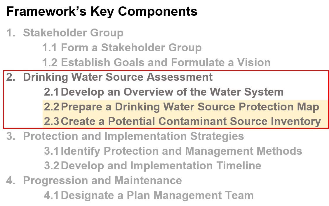
Finishing Phase 2 of the Framework for Creating a DWSP2 Plan
- 2.2 Prepare a Drinking Water Source Protection Map (Continued)
- 2.3 Create a Potential Contaminant Source Inventory
Grant Program Now Available!Before we continue our closer look into Phase 2 of the DWSP2 Framework, we wanted to make you aware of an exciting grant program that is available for you to apply to: Trees for Tribs Buffer in a Bag Program. The application period for DEC’s Trees for Tribs Buffer in a Bag Program is now open. Private and public landowners who qualify may apply for a free bag of 25 tree and shrub seedlings for planting near streams, rivers, or lakes to help stabilize banks, protect water quality, and improve wildlife habitat. A total of 500 bags will be available statewide for this round of applications. Applications are due by 3:00 p.m. on April 12. Contact treesfortribs@dec.ny.gov with questions and visit the Trees for Tribs Program on DEC's website to learn more. Let's continue our deeper dive into "A Framework for Creating a Drinking Water Source Protection Program Plan" as introduced in our December issue. This will provide you with a synopsis of each of the four phases and eight key components of a protection plan. In this month’s issue, we will be looking into the last two components of Phase 2 of the DWSP2 Framework: Drinking Water Source Assessment.
2.2 Prepare a Drinking Water Source Protection Map (Continued)In last month’s issue, you learned the critical steps involved in developing your community’s drinking water source protection map. Step 4 in that list is to delineate your source water protection area or areas. You may have asked yourself; how do I do this? Let’s take a look:
The Framework defines and discusses a list of source water protection areas a community is encouraged to delineate as part of their mapping efforts. Each area is established to protect the source against possible sources of contamination. The required and recommended protection areas are:
The critical and source water area are broken down by the time it may take for a contaminant to reach the drinking water source. These two areas may be delineated using a fixed radius, time of travel, or a combination of these methods. The Framework will walk you through all of the protection areas and delineation options for your source.
I have a groundwater source. What steps should I be taking?If your community is delineating a groundwater source, they should review the groundwater specific required and recommended protection areas in the resource kit of the Framework. The Framework will discuss how protection areas can be calculated, factors to consider, what methods are available, and what might be best for your community.
A map showing a groundwater wellhead and time of travel source water protection areas from Delineate the Source Water Protection Area | Source Water Protection | US EPA. I have a surface water source. What steps should I be taking?If your community is delineating a surface water source, they should review the surface water specific recommended protection areas in the resource kit of the Framework. Protection areas will depend on your surface water type as well as slope and soil type.
A map showing a surface water intake and the delineated source water protection areas from Delineate the Source Water Protection Area | Source Water Protection | US EPA. What tools are available?The Framework links to a number of resources and tools that you can use to delineate your community’s source. The most commonly used tools we have seen so far are:
Who can I reach out to for help?We recognize that technical assistance may be needed to complete Component 2.2 (Prepare a Drinking Water Source Protection Map). If you need assistance with groundwater or surface water delineations or with picking an appropriate method, please reach out to the New York State Drinking Water Source Protection Program team at source.water@dec.ny.gov.
2.3 Create a Potential Contaminant Source Inventory
For this component, you will first identify all potential contaminant sources within your drinking water source protection area and then gather information specific to each one. This will help the community understand where they need to focus protection efforts. Just a reminder that this component should be completed with component 2.2 (Prepare a Drinking Water Source Protection Map).
First, what is a potential contaminant source?It is any activity or facility that stores, uses, and/or produces chemicals, and has the potential to release contaminants in amounts that could significantly impact drinking water sources. You can visit this section of the Framework to view examples of potential contaminant sources that could impact the quality of drinking water sources.
A snapshot of the Potential Contaminant Sources List from Component 2.3 Create a Potential Contaminant Source Inventory of the Framework. Now that we know what a potential contaminant source is, let’s look at the four steps for creating a Potential Contaminant Source Inventory outlined in the Framework. A quick summary of each is below:
A map showing potential contaminant sources within the source water protection area of a surface water source from Inventory Potential Contaminant Sources | Source Water Protection | US EPA What resources are available?There are a number of publicly available resources you can use to identify potential contaminant sources and complete your inventory:
The Framework lists additional resources to aid with this component.
Our next edition will cover Phase 3: Protection and Implementation Strategies. Share Your ThoughtsHave you begun this process? Send in any helpful hints or lessons learned at source.water@dec.ny.gov and we may highlight them! Sign UpTo sign-up for the DWSP2 newsletter, visit the DWSP2 webpage or click here. Newsletter ArchiveMissed last month’s edition? Visit the DWSP2 Newsletter Archive to stay up to date. |


|
The New York State Department of Environmental Conservation respects your right to privacy and welcomes your feedback | Update preferences or unsubscribe | Learn more about DEC Delivers |
|
| Connect with DEC: |
|
| Basil Seggos, Commissioner | |