
Drinking Water Source Protection Program (DWSP2) - Monthly Newsletter
The New York State Department of Environmental Conservation sent this bulletin on 02/12/2021 03:38 PM EST |
| DEC Delivers - Information to keep you connected and informed from the NYS Department of Environmental Conservation |
| Share or view as a web page || Update preferences or unsubscribe |
Drinking Water Source Protection Program - February Newsletter
This issue's topics:
-
Introduction to Phase 2 of the Framework for Creating a DWSP2 Plan
- 2.1 Develop an Overview of the Water System
- 2.2 Prepare a Drinking Water Source Protection Map
|
Over the course of the next few newsletters, we will be taking a deeper dive into "A Framework for Creating a Drinking Water Source Protection Program Plan" as introduced in our December issue. This will provide you with a synopsis of each of the four phases and eight key components of a protection plan. In this month’s issue, we will be looking into Phase 2 of the DWSP2 Framework: Drinking Water Source Assessment.
Preparing for Phase 2The goal for this section is to develop a comprehensive assessment of the drinking water source that draws information from all available relevant documents such as the community’s original Source Water Assessment Program (SWAP) report, or Annual Water Quality Report, as well as, additional information gathered during the key components of the Drinking Water Source Assessment phase. 2.1 Develop an Overview of the Water SystemWhere do we start?Now that you have set up your stakeholder group and established your goals and formulated a vision, it is a good time for everyone to understand the water system. This will aid the group with:
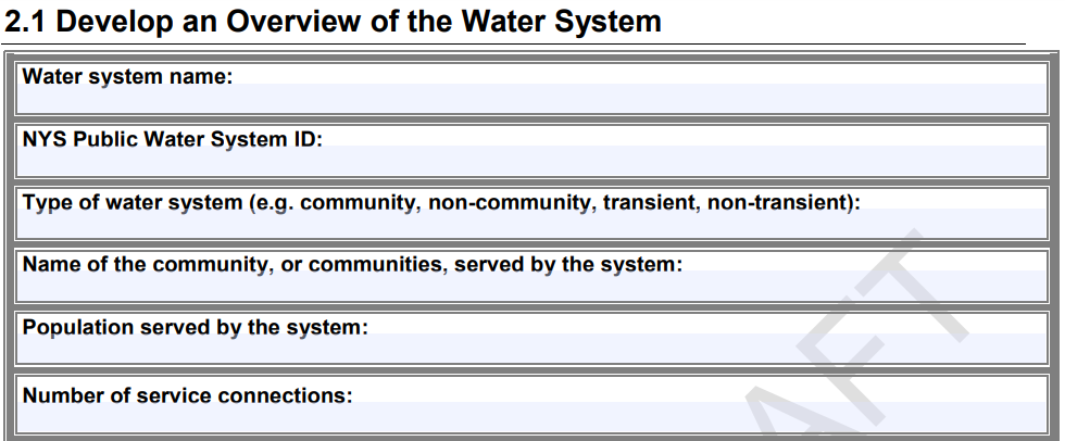
Where can I go to find information?A great resource for this component is your local drinking water operator. They will have the most knowledge about the public water supply system including well or intake locations, system infrastructure, pumping rates, raw and finished water quality, and more. They may be able to fill in much of the information found in the Develop an Overview of the Water System Worksheet.
A screenshot of the Working Draft Framework showing the Develop an Overview of the Water System Worksheet. In addition to information your water operator may have, another good source of information is your Annual Water Quality Report. This should contain a summary of your source water, water quality sampling, any violations, and more. Below are more sites and reports you can use to gather more information about your water system:
2.2 Prepare a Drinking Water Source Protection MapWith an understanding of your water system, you can now turn your focus to preparing a drinking water source protection map. This map will guide the development of the DWSP2 Plan by delineating and/or displaying drinking water source protection areas, land use, and potential contaminant sources. Mapping tools, often referred to as Geographic Information System (GIS) software, are invaluable in assisting a community with delineating and visualizing protection areas and preparing a drinking water source protection map. We recognize that technical assistance may be needed to complete Component 2.2 (Prepare a Drinking Water Source Protection Map), particularly with GIS. If you need assistance with mapping, please reach out to the New York State Drinking Water Source Protection Program team at source.water@dec.ny.gov. This component should be done concurrently with Component 2.3 (Create a Potential Contaminant Source Inventory) to have a complete map representing your source and surrounding area. Component 2.3 will be covered in the next edition of our newsletter. Where do we start?Preparing a drinking water source protection map may involve revisiting the old SWAP report and using the Develop and Overview of the Water System Worksheet to create a new map with updated information.
The SWAP report may include information about the drinking water sources, land uses, and potential contaminant sources. However, most of the reports are around 20 years old so information should be checked and updated as needed.
If you do not have a previous SWAP report or map, the Framework will still guide you through creating a drinking water source protection map.
Below are critical steps in developing a drinking water source protection map. For more information on each step, take a peek at Component 2.2 of the Framework:
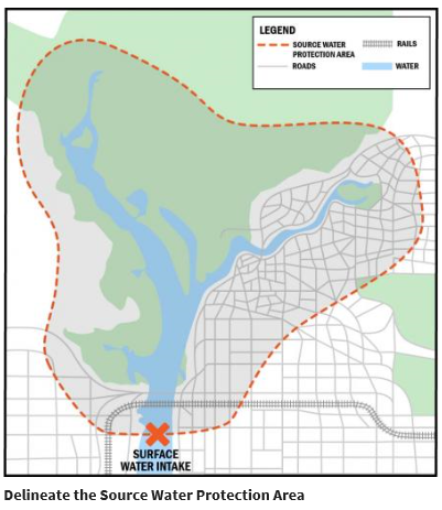
A map showing a surface water intake and the delineated source water protection area from Delineate the Source Water Protection Area | Source Water Protection | US EPA. Following these steps will ensure that you create a useful and complete source water protection map for your community. In our next edition, we will continue to take a deeper dive into Phase 2: Drinking Water Source Assessment and go over how to Create a Potential Contaminant Source Inventory. Share Your ThoughtsHave you begun this process? Send in any helpful hints or lessons learned at source.water@dec.ny.gov and we may highlight them! Sign UpTo sign-up for the DWSP2 newsletter, visit the DWSP2 webpage or click here. Newsletter ArchiveMissed last month’s edition? Visit the DWSP2 Newsletter Archive to stay up to date. |
|
The New York State Department of Environmental Conservation respects your right to privacy and welcomes your feedback | Update preferences or unsubscribe | Learn more about DEC Delivers |
|
| Connect with DEC: |
|
| Basil Seggos, Commissioner | |