|
Have a safe and enjoyable outdoor recreational experience on the lands and waters of the Adirondacks. Properly plan and prepare for your outdoor adventure. Minimize the impact on the mountains and forests, rivers and brooks, ponds and lakes, and the wildlife of the Adirondacks.
Check the Backcountry Information for the Adirondacks web pages for more detailed information on access, outdoor recreation infrastructure, and conditions for those planning to recreate in the Adirondacks. This bulletin provides only the most recent notices.
Emergency Situations: If you get lost or injured; keep calm and stay put. If you have cell service, call 911 or the DEC Forest Ranger Emergency Dispatch, 518-891-0235.
Check mountain weather conditions before heading out this weekend.
Packing the proper gear for a hike is very important, and you should be prepared to encounter all conditions. See our recommended packing list and safety tips.
Bear Advisory: While preparing for your camping or hiking trip, check area notices for active bear advisories. If there are active bears present where you are planning to go, either choose an alternative trip or thoroughly educate yourself on proper food storage, disposal of food waste, and what to do if you happen to encounter a bear. Learn more about avoiding nuisance bears.
Parking restrictions along Route 73: Parking is prohibited on the shoulders of State Route 73 between Chapel Pond and Rooster Comb Trailhead. Violators will be ticketed. Park in designated pull offs and trailhead parking areas only.
Leave No Trace Hot Spot Events - August 7th-14th: The Leave No Trace Center for Outdoor Ethics and its Subaru Traveling Trainer team are partnering with ADK (Adirondack Mountain Club), DEC, and other regional organizations to host a series of events over the course of the week focusing on the heavily-visited Eastern High Peaks Wilderness. The Hot Spot will address the challenges associated with high concentrations of visitors to the region, including damage to alpine plants, trail erosion, human waste, and negative human/wildlife interactions. Find all the ways you can get involved. All events are free and open to the public.
Plan Ahead
Check weather and trail conditions, regulations, and advisories before you travel. Have an alternative plan ready to ensure you can make the most of your time in the Adirondacks.
-
Know the group size regulations: Group size regulations allow for groups of no more than 15 people for a day hike and no more than 8 people for an overnight trip. This is to help reduce the amount of impact to the trail system or camping area and reduce the impact to the experience of those around your group.
-
When hiking in a group, hike single file so your boots fall in line with the hiker ahead of you. This keeps the impact to the soil focused to one central spot on the trail and protects the outer edge of the trail and surrounding vegetation from being trampled.
-
When camping in a group, keep your tents close together and your camp site contained to a small radius. This will focus your group's impact to the designated camping area, protecting the surrounding forest and vegetation.
-
In both group situations, always be respectful of other hikers and campers by keeping your noise level to a minimum, respecting other hikers' abilities and speed, keeping a clean campsite, and always carrying out what you carried in.
-
Bear Activity: A nuisance bear has been active in the Eastern High Peaks. The bear is approaching hikers and campers in an attempt to obtain food. Bear canisters are currently required in the High Peaks Wilderness and strongly recommended throughout the rest of the park. Be sure all of your food and waste will fit securely within the bear canister. If you’re not sure about an item, pack it in your canister anyway.
- Do not eat or store food where you sleep. Cook and store food 100 feet or more from lean-tos and tent sites.
- Bear hangs are not effective. Lock all food, garbage, and toiletries in bear resistant containers.
- Bear spray is an option for close encounters. Keep it on you and easily accessible.
- Do not leave packs unattended on trails.
-
Report nuisance bear incidents to DEC.
Prepare
Properly prepare to better ensure a safe and enjoyable outdoor recreation experience. Weather forecasts and conditions can and do change quickly. Check the current National Weather Service Forecast, and be prepared for the forecasted conditions, or change your plans.
-
Temperature variances: Adirondack nights and morning are beginning to see temperatures in the 40’s and 50’s. Start your morning hike in warm layers and pack extra warm layers to prevent hypothermia, should an unexpected hike down in the dark or overnight in the woods happen. Campers should be aware of these temperature drops and pack warm clothes and sleeping bags rated for colder weather.
-
Do not rely on your cellphone: This is true all the time, but with temperatures beginning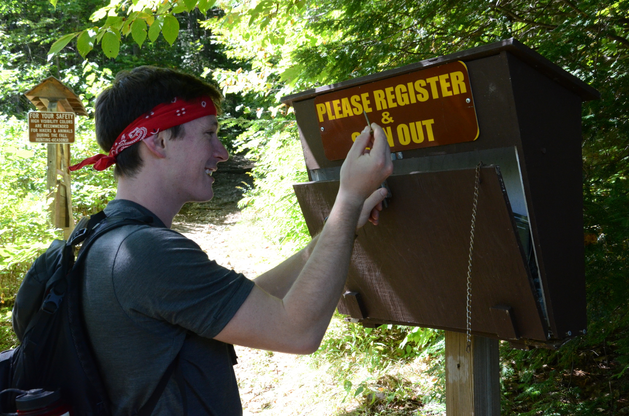 to drop in the evening and overnight, cell phone batteries can die quickly. Always bring a headlamp and extra batteries for unexpected hikes out in the dark or unexpected overnight stays in the woods. Leave your itinerary with friends or family. If you surpass your expected return time, they can call 911 or DEC dispatch for assistance to find you. Always sign in and out of trail head registers so DEC forest rangers can locate your intended trip plan. to drop in the evening and overnight, cell phone batteries can die quickly. Always bring a headlamp and extra batteries for unexpected hikes out in the dark or unexpected overnight stays in the woods. Leave your itinerary with friends or family. If you surpass your expected return time, they can call 911 or DEC dispatch for assistance to find you. Always sign in and out of trail head registers so DEC forest rangers can locate your intended trip plan.
-
Wildlife encounters:
- Always view wildlife from a distance, giving the animal enough space to hardly know you are present.
- Do not approach. Wildlife can become aggressive at any point if they feel threatened.
- Do not feed wildlife. This can condition them to only survive on human food which creates negative human-wildlife encounters and is fatal to the animal.
- If you have a close encounter with larger wildlife life bears or moose, remain calm and begin to back away slowly. Always keep your packs on your back, and do not leave them unattended on any trail.
- Report wildlife encounters to DEC.
Practice Leave No Trace
 Follow proper trail etiquette to maintain minimal impact on the environment and the natural resources of the Adirondacks, as well as ensure an enjoyable outdoor experience for all visitors by following the Seven Principles of Leave No Trace. Follow proper trail etiquette to maintain minimal impact on the environment and the natural resources of the Adirondacks, as well as ensure an enjoyable outdoor experience for all visitors by following the Seven Principles of Leave No Trace.
How do you properly dispose of your pet’s waste on the trail?
- There are a few options when hiking with your furry friend on how and where to dispose of their inevitable waste.
- The first option is the doggy bag option. If carrying a doggy bag to pack out your pet’s waste, be sure you actually carry the waste the duration of your hike and throw it away in an actual trash receptacle. Do not leave the full doggy bag on the side of the trail, on the summit, on the trail register, in the parking area, in the porta-potty, hanging from a tree, or tossed into the woods. Not all trail heads and parking areas have trash receptacles, so have a plan like a heavier bag or bucket in your vehicle to bring the waste with you to the nearest receptacle.
- If using a biodegradable doggy bag option, the bag can still take up to six months to decompose, but that’s just the bag. The waste inside the bag can take an additional three months to go unseen. Parasites from the waste can linger in the surrounding soil for several years beyond that.The average trail in the high peaks can see over 20 dogs in one day. Compound the action of one doggy bag left behind by one person on one day by hundreds or thousands. That is some serious waste along our trails!
- If you are unprepared to carry your pet’s waste the duration of the hike, do not consider doggy bags as an option that will work for you. Instead, bring a small shovel and opt to bury your pet’s waste, similar to disposing human waste in the back country. Dig a 6-8 inch hole in sunny soil away from the trail and at least 150 ft. from any water source. Bury your pet’s waste in the hole.
General Conditions/Notices
Learn the conditions you will encounter from Adirondack Backcountry Information.
All
-
Travel: Check NY511 for road closures and conditions.
- Summer Weather:
- Cooler temperatures with daytime highs in the 60s and 70s, nighttime lows around 40.
- Check the National Weather Service or NY Mesonow for updated hazardous weather notices and for current conditions and forecasts for the location where you plan to recreate.
-
Thunderstorm Safety: Thunderstorms can pop up even if they are not forecast.
- Avoid summits, water surfaces and other open areas during thunderstorms.
- As soon as you are first aware of an approaching thunderstorm, move to lower elevations, head to shore, and seek shelter.
- If caught outside in a thunderstorm, find a low spot away from tall trees, seek an area of shorter trees and crouch down away from tree trunks.
-
Biting Insects: It is bug season in the Adirondacks. Expect to encounter deer flies, mosquitoes, no-see-ums (biting gnats), and ticks. Follow these steps to minimize the nuisance of biting insects:
- Wear light-colored, long sleeve shirts and long pants.
- Tuck shirts into pants, button or rubber band sleeves at the wrist, and tuck the bottom of pant legs into your socks.
- Pack a head net to wear when insects are thick.
- Use an insect repellent and follow label directions.
- View these additional tips for tick prevention.
-
Fire Danger:
- Low, throughout the Adirondacks.
- Check the Fire Danger Rating Map. to determine the Fire Danger Rating Area and updates to the Fire Danger Rating.
-
Seasonal Access Roads: All but two seasonal access roads are open to public motor vehicle traffic. Check the Specific Notices below for roads that remain closed.
- Seasonal access roads are dirt and gravel which can be rough.
- Four-wheel drive SUVs, pick-up trucks, and other high clearance vehicles are recommended for driving on these roads.
- Roads may be narrow – use caution, drive slowly, and watch for oncoming vehicles.
Hikers & Campers
-
General Information:
-
Trail Conditions:
- Due to recent heavy rains, expect to encounter wet and muddy conditions on
 trails. trails.
- Wear footwear suitable for hiking through wet and muddy areas.
- Protect trails and trailside vegetation – stay in the center of the trail and walk through mud and water, not around it.
- Be aware that water levels will increase during and immediately after significant rain events - low water crossings may be difficult to cross.
-
Bear Resistant Canisters:
- Using bear-resistant canisters ensures campers don’t lose food, prevents creating nuisance bears, and is required for overnight users in the Eastern High Peaks Wilderness between April 1 and November 30.
- All food, toiletries and garbage must be stored in bear-resistant canisters.
- DEC encourages the use of bear-resistant canisters and other practices to avoid negative encounters with bears throughout the Adirondacks.
-
Mountain Summits:
Bikers
-
General Information: Biking
- Trail Conditions:
- Due to recent heavy rains, trails or sections of trails may be muddy.
- Do not ride on muddy trails. They are easily rutted and damaged through use - if you are leaving tracks, turn back.
- The Barkeaters Trail Alliance provides information on the status of mountain bike trails in the Tri-lakes region of the Adirondacks.
-
E-bikes: Electric powered bikes are prohibited on all bike trails on the Forest Preserve.
Boaters, Paddlers, and Anglers
-
General Information
- Condition
- Water levels in many rivers and streams are below average to low.
- Water temperatures are warm, though high elevation brooks will be cool.
- DEC strongly recommends anglers, boaters and paddlers wear personal flotation devices (PFDs aka lifejackets).
-
Heat Stressed Trout and Salmon: Trout and salmon can experience physical stress whenever water temperatures climb above 70 degrees Fahrenheit.
- In streams, heat-stressed fish will seek deep pockets of cold water, small feeder streams, or water released from deep reservoirs.
- These refuges allow trout to avoid or recover from potentially fatal levels of heat stress.
- Anglers can help trout and salmon by taking the following precautions during warm-weather fishing trips:
- Avoid catch-and-release fishing for heat-stressed trout on hot days.
- Do not disturb trout where they have gathered in unusually high numbers.
- Fish early in the day.
- Always have an alternate fishing plan in case water temperatures are too high at the intended destination.
Climbers
-
Rock Climbing Route Closures: All rock climbing routes are open. DEC appreciates the cooperation and understanding of the climbing community during the closure period. Rock climbers also volunteer to identify nesting pairs, nest sites, and observed nest sites until the young fledge.
Recent Notices
Notices below reflect recent changes in conditions and recreation infrastructure work completed by DEC and its partners. Check the Adirondack Backcountry Information web pages for ongoing issues and more detailed information.
-
Saranac Lake Wild Forest: Beginning mid-August, the Department of Transportation will be replacing the Spider Creek Culvert on State Route 30 between Follensby Clear Pond and Fish Creek Ponds.

- During the construction, watercraft will not be able to pass through the culvert.
- A temporary canoe carry to bypass the culvert may be established, but people paddling in this should consider using existing canoe routes that avoid this culvert entirely.
- If you use the temporary canoe carry, be cautious, pay attention to signage, and obey crosswalk signals.
- Parking at the water access site near the construction site will be open, but may be congested.
- The northern entrance to this parking area will be blocked.
- The culvert will be closed through November.
-
Wilcox Lake Wild Forest: A 250-foot section of the Murphy-Middle-Bennett Trail has been rehabilitated. DEC staff, backcountry stewards, and volunteers from the Velo Bicycle Club and the community spent four days rehabilitating the section of trail using sustainable practices to create a durable and hardened trail surface for multi-use recreation. DEC used the existing corduroy surface as the foundation for the crushed stone turnpike built on top of it. View press release for more information.
-
Ausable Mountain Reserve Conservation Easement Tract/High Peaks & Giant Mountain Wildernesses:
-
Be safe, enjoy your hike, and avoid a parking ticket.
-
Do not park on the shoulders of State Route 73 in the four-mile section 73 between Chapel Pond and the Rooster Comb Trailhead.
- Parking is allowed at trailheads and other designated pull-offs.
- Hikers planning to use the AMR parking lots and hike any of the nearby trails should identify alternate hikes before arriving as the lots will fill quickly.
- DEC encourages hikers to discover and visit the other numerous hiking opportunities in the area, or visit on weekdays when there is less demand.
-
Hikes Outside the Adirondack High Peaks lists a dozen nearby alternate hikes.
-
Boreas Ponds Tract: Work on Gulf Brook Road continues.
- The road is closed to motor vehicles Monday through Thursday.
- Hikers, bikers, and horseback riders may use the road but must use caution in active work areas and follow the instructions of staff.
- The road is open to the Fly Pond Gate Friday through Sunday.
-
High Peaks Wilderness:
- There has been increased bear activity at Marcy Dam and Feldspar. Avoid problems with bears:
- Cook early.
- Secure canister immediately after taking food out.
- Consider bear spray for unexpected close encounters.
Highlighted Trip - Big Pond, Schroon Lake, NY
Big Pond is located 1.0-mile from the Big Pond Trailhead Parking Area in the Hoffman Notch Wilderness. Big Pond is great for fishing and is dominated by northern pike, but also contains brown bullhead. Hikers can choose to hike 1 mile to the pond or continue down the Big Pond Trail another 4.7 miles to intersect with the Hoffman Notch Trail.
Hoffman Notch is a 38,488-acre wilderness named for the “notch” or valley between the Blue Ridge Mountain Range and the Washburn Mountain Range. The area features ponds and streams for fishing and 15 miles of trails for hiking, snowshoeing and skiing. It also offers visitors solitude, as one of the less visited areas in the Adirondacks.
Big Pond Trailhead Parking Area is on the north side of Hoffman Notch Road. (43.8455° N, 73.8044° W)
DEC Launches New 'DECinfo Locator' to Increase Transparency and Access to Data and Reports
 DEC recently launched DECinfo Locator, an interactive map that provides access to DEC documents and public data about New York's environment and outdoor recreation resources. This first-of-its-kind DEC mapping application generates results specific to locations across the state and includes 50 interactive data layers. Several information layers can be active at the same time, allowing users to see the many ways DEC is working to protect and enhance the state’s environment and recreational opportunities. DEC recently launched DECinfo Locator, an interactive map that provides access to DEC documents and public data about New York's environment and outdoor recreation resources. This first-of-its-kind DEC mapping application generates results specific to locations across the state and includes 50 interactive data layers. Several information layers can be active at the same time, allowing users to see the many ways DEC is working to protect and enhance the state’s environment and recreational opportunities.
Among other uses, the public can:
- Explore new places for recreation such as hiking, cross-country skiing, or mountain biking
- Look up the rules for a nearby Wildlife Management Area
- Access a web page with details about allowed uses on a nearby Conservation Easement
- Find a DEC campground and see photos of individual campsites (where available)
- Activate the Public Fishing Rights layer to see your favorite fishing locations and nearby boat launches, then overlay information about the water quality of lakes, rivers, and streams to access DEC data for specific locations
To access the mapping application, visit the DECinfo Locator web page. Learn more about its features from the DECinfo Locator Tutorial on YouTube.
|

