|
Have a safe and enjoyable outdoor recreational experience on the lands and waters of the Adirondacks. Properly plan and prepare for your outdoor adventure. Minimize the impact on the mountains and forests, rivers and brooks, ponds and lakes, and the wildlife of the Adirondacks.
Check the Backcountry Information for the Adirondacks web pages for more detailed information on access, outdoor recreation infrastructure, and conditions for those planning to recreate in the Adirondacks. This bulletin provides only the most recent notices.
Emergency Situations: If you get lost or injured; keep calm and stay put. If you have cell service, call 911 or the DEC Forest Ranger Emergency Dispatch, 518-891-0235.
Check mountain weather conditions before heading out this weekend.
Packing the proper gear for a hike is very important, and you should be prepared to encounter all conditions. See our recommended packing list and safety tips.
Bear Advisory: While preparing for your camping or hiking trip, check area notices for active bear advisories. If there are active bears present where you are planning to go, either choose an alternative trip or thoroughly educate yourself on how to reduce your chance of a bear encounter with proper food storage, disposal of food waste, and then what to do if you happen to encounter a bear. Learn more about avoiding nuisance bears.
Parking restrictions along Route 73: Parking is prohibited on the shoulders of State Route 73 between Chapel Pond and Rooster Comb Trailhead. Violators will be ticketed. Park in designated pull offs and trailhead parking areas only.
Leave No Trace Hot Spot Events- August 7th-14th: The Leave No Trace Center for Outdoor Ethics and its Subaru Traveling Trainer team are partnering with ADK (Adirondack Mountain Club), the New York State Department of Conservation, and other regional organizations to host a series of events over the 10 days focusing on the heavily-visited Eastern High Peaks Wilderness. The Hot Spot seeks to address the challenges associated with high concentrations of visitors to the region, including damage to alpine plants, trail erosion, human waste, and negative human/wildlife interactions. Find all the ways you can get involved. All events are free and open to the public.
Plan Ahead
Check weather and trail conditions, regulations, and advisories before you travel. Have an alternative plan ready to ensure you can make the most of your time in the Adirondacks.
- Tips to stay hydrated.
- Drink more than necessary the week leading up to your hiking trip.
- Drink 1-2 cups of water or a sport drink before beginning your hike.
- Limit the amount of caffeine drinks. Caffeine increases fluid loss and can dehydrate you faster.
- During the hike, drink at least 1qt. of water per hour.
- Alternate between water and electrolyte or sport beverage. Sports drinks or electrolyte tabs help retain fluids and maintain energy.
- Drink more than you think is necessary.
- Assess your hydration along your hike by looking for signs of: low volumes of dark urine, rapid heart rate, weakness, excessive fatigue, or dizziness.
- Continuing to hike in a dehydrated state can lead to serious consequences, including heat stroke, muscle breakdown, and kidney failure.
- Rehydration is essential when you’ve completed your hike- rehydration is enhanced when fluids or foods contain sodium and potassium like; bananas, citrus fruits, lemonade, and orange juice.
-
Share the roads: Cyclists are utilizing the busy north country roads training for the Lake Placid Ironman at the end of July. Motorists should be alert on all roadways and double check shoulders before turning into parking areas, driveways or onto other roads.
Prepare
Properly prepare to better ensure a safe and enjoyable outdoor recreation experience. Weather forecasts and conditions can and do change quickly. Check the current National Weather Service Forecast, and be prepared for the forecasted conditions or change your plans.
-
Summer weather is upon us! Follow these summer preparedness tips before hitting the trail:
- Rest and hydrate often to help combat the humidity and heat exhaustion.
- Apply sunscreen and Chapstick with SPF liberally and often.
- Bring plenty of food to keep up with the calories you'll burn.
- Keep an eye and ear on the weather. Summer heat can bring unexpected thunderstorms in the mountains.
- Always bring a headlamp, first aid kit, and map of your planned route.
- Plan to start your hike early in the morning when the temperatures are cool.
-
Know the signs of heat exhaustion. If you experience any of these symptoms below, take a rest by finding a shady area, drink plenty of water and take measures to cool yourself down. If there is a nearby stream, splash your face, neck and wrists with the cool water. Do not try to hike further until your symptoms have completely faded. If you try to exert yourself too soon, the symptoms will only increase your chance of a heat stroke.
- Cool, moist skin with goose bumps when in the heat
- Heavy sweating
- Faintness
- Dizziness
- Fatigue
- Weak, rapid pulse
- Low blood pressure upon standing
- Muscle cramps
-
Unexpected Weather: Temperatures in the high 80s/low 90s can bring unexpected severe thunder and lightning storms in high elevation mountains. Keep an eye on the sky and listen for signs of thunder, especially in late afternoon.
- If you find yourself on a summit with a storm approaching, quickly get yourself back below tree line to an area where the forest trees are evenly spread. If in a group, spread out while descending. Do not sit under an isolated tree or near tree bases, overhanging rocks or near streams of water. Continue to the lowest ground possible or if in a safer place, sit on your backpack with your feet together to minimize your contact with the ground.
Practice Leave No Trace
 Follow proper trail etiquette to maintain minimal impact on the environment and the natural resources of the Adirondacks, as well as ensure an enjoyable outdoor experience for all visitors by following the Seven Principles of Leave No Trace. Follow proper trail etiquette to maintain minimal impact on the environment and the natural resources of the Adirondacks, as well as ensure an enjoyable outdoor experience for all visitors by following the Seven Principles of Leave No Trace.
Summer is a great time for getting outdoors, but it also means an influx of people on the trails and summits. Be considerate of other visitors and enjoy your experience by following these tips for handling busy weekends on the trails:
-
Have patience! It’s easy to forget that when faced with a crowd of people on the trail or on a summit that you are also part of the crowd. Remember that everyone is out to enjoy their own personal experience and journey in the wilderness. Show kindness and support for those you may pass along the way. Share the views at the summit and overlooks so everyone has a chance to soak in the beauty, and keep noise levels to a minimum.
-
Get up earlier! The earlier you rise, the fewer people will be on the trail. Parking is easier to find, and you will find yourself alone or among the few other early risers at your destination.
-
Explore areas that are less popular! Research and keep a bank of less traveled and less popular trails and areas. Explore them when there are times of high use in the highly popular places. Some of the best destinations and views are found on the trails less known.
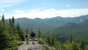
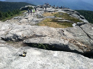 Alpine Vegetation: The summit of a high peak is an amazing place to be. While you're soaking in the accomplishment of your hard work and the beauty of the views, don’t forget to watch where you’re walking. The High Peaks of the Adirondacks are home to rare and endangered alpine vegetation that live and thrive on our rocky summits, and it’s up to you to help protect it. Alpine Vegetation: The summit of a high peak is an amazing place to be. While you're soaking in the accomplishment of your hard work and the beauty of the views, don’t forget to watch where you’re walking. The High Peaks of the Adirondacks are home to rare and endangered alpine vegetation that live and thrive on our rocky summits, and it’s up to you to help protect it.
- Keep a clean trail and summit so alpine vegetation can grow healthy and freely
- Stay on the trail and on the rocks to avoid trampling and damaging alpine vegetation
- Carry a rock to the summit to help summit stewards build trail cairns and rock screes that help protect the vegetation
General Conditions/Notices
Learn the conditions you will encounter from Adirondack Backcountry Information
All
-
Travel: Check NY511 for road closures and conditions.
-
Summer Weather: Temperatures are warming, and rain is less frequent.
- Daytime temperatures are regularly in the high 70s and 80s.
- Nighttime temperatures are still cool, especially in the higher elevations.
- Rain is common but not as continuous as it was in the spring.
- Check the National Weather Service or NY Mesonow for current conditions and forecasts for the location where you plan to recreate.
-
Biting Insects: It is bug season in the Adirondacks. Expect to encounter deer flies, mosquitoes, and ticks. Follow these steps to minimize the nuisance of biting insects:
- Wear light-colored, long sleeve shirts and long pants.
- Tuck shirts into pants, button or rubber band sleeves at the wrist, and tuck the bottom of pant legs into your socks.
- Pack a head net to wear when insects are thick.
- Use an insect repellent and follow label directions.
- Additional tips for tick prevention.
-
Avoid Heat Exhaustion and Heat Stroke: During hot weather:
- Wear sunscreen and a hat
- Slow your pace
- Drink water and rest more often
- Seek shade and avoid long periods in direct sunlight
- Dogs are more susceptible to heat – follow the tips above and observe them closely for heat stress.
- Do not hike in extremely hot weather. If you do, please leave your dogs at home.
-
Thunderstorm Safety: Thunderstorms can pop up even if they are not forecast.
- Avoid summits, water surfaces and other open areas during thunderstorms.
- As soon as you are first aware of an approaching thunderstorm, move to lower elevations, head to shore, and seek shelter.
- If caught outside in a thunderstorm, find a low spot away from tall trees, seek an area of shorter trees and crouch down away from tree trunks.
-
Fire Danger: Low, throughout the Adirondacks. Check the Fire Danger Rating Map.
-
Seasonal Access Roads: All but a very few seasonal access roads are open to public motor vehicle traffic. Check the Specific Notices below for roads that remain closed.
- Seasonal access roads are dirt and gravel which can be rough.
- Four-wheel drive SUVs, pick-up trucks, and other high clearance vehicles are recommended for driving on these roads.
- Roads may be narrow – use caution, drive slowly, and watch for oncoming vehicles.
Hikers & Campers
-
General Information:
-
Trail Conditions:
- Expect to encounter wet and muddy conditions on trails – especially in low areas, along waterbodies, and after rain events:
- Wear footwear suitable for hiking through wet and muddy areas.
- Please protect trails and trailside vegetation – stay in the center of the trail and walk through mud and water, not around it.
- Be aware that water levels will increase during and immediately after significant rain events - low water crossings may be difficult to cross.
-
Bear Resistant Canisters:
- The use of bear-resistant canisters ensures campers don’t lose food, prevents creating nuisance bears, and is required for overnight users in the Eastern High Peaks Wilderness between April 1 and November 30.
- All food, toiletries and garbage must be stored in bear-resistant canisters.
- DEC encourages the use of bear-resistant canisters and other practices to avoid negative encounters with bears throughout the Adirondacks.
-
Mountain Summits:
 Bikers Bikers
-
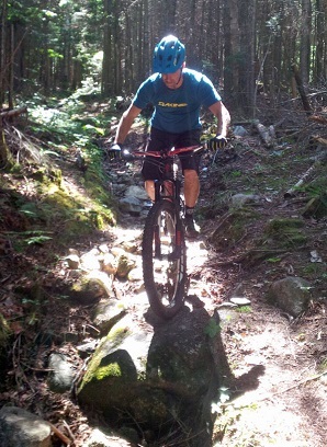
General Information: Biking
- Trail Conditions:
- Trails are in good condition, however, you may encounter muddy trails or sections of trails.
- Please don’t ride on muddy trails, they are easily rutted and damaged through use - if you are leaving tracks, turn back.
- The Barkeaters Trail Alliance provides information on the status of mountain bike trails in the Tri-lakes region of the Adirondacks.
-
E-bikes: Electric powered bikes are prohibited on all bike trails on the Forest Preserve.
Boaters, Paddlers, and Anglers
-
General Information
- Condition
- Water levels are in the average range, but due to saturated soils, they can rise quickly in smaller rivers and streams after significant rain events.
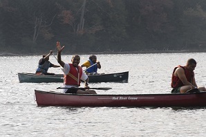
- Personal Flotation Devices (PFDs aka lifejackets) are strongly recommended to be worn by all anglers, boaters, and paddlers.
- Check the USGS Current Water Data for New York for stream flow of selected waters.
-
DEC Boat Launches: Docks have been installed at all boat launches.
Climbers
Recent Notices
Notices below reflect recent changes in conditions and recreation infrastructure work completed by DEC and its partners. Check the Adirondack Backcountry Information web pages for ongoing issues and more detailed information.
-
 Ausable Mountain Reserve Conservation Easement Tract/High Peaks & Giant Mountain Wildernesses: Ausable Mountain Reserve Conservation Easement Tract/High Peaks & Giant Mountain Wildernesses:
-
Be safe, enjoy your hike, and avoid a parking ticket.
-
Do not park on the shoulders of State Route 73 in the four-mile section 73 between Chapel Pond and the Rooster Comb Trailhead. Officers have and will continue to issue tickets for vehicles parked in no parking zones.
- Parking is allowed at trailheads and other designated pull-offs.
- Hikers planning to use the AMR parking lots and hike any of the nearby trails should identify alternate hikes before arriving as the lots will fill quickly.
- DEC encourages hikers to discover and visit the other numerous hiking opportunities in the area, or visit on weekdays when there is less demand.
-
Hikes Outside the Adirondack High Peaks lists a dozen nearby alternate hikes.
-
Boreas Ponds Tract: Work on Gulf Brook Road continues to be delayed.
- The road will be open seven days a week to the Fly Pond Parking Area until further notice.
- DEC will provide notice here when the work starts, and the road will be open on Saturdays and Sundays only.
-
High Peaks Wilderness:
- Due to unforeseen circumstances, the replacement of Johns Brook Road Bridge will not be completed until early September.
- Hikers will only be able to access The Garden Trailhead using the shuttle from Marcy Field until then.
- Check the Town of Keene’s website for shuttle information.
- Hikers seeking to use the Mt. Van Hoevenberg East Trail, which opened last fall, will be re-routed around the construction underway to make significant improvements to Olympic Sports Complex facilities.
- Hikers can park at the Biathlon Facility parking area in the Complex and use a marked 1.0-mile detour bypassing the construction zone using roads, ski trails, and a temporary trail to reach the Mt. Van Hoevenberg East Trail.
- It is a 3.8-mile round-trip hike from the parking area to the summit and back.
- Expect to encounter trail workers along the trail to the summit of the mountain as they complete the final touches on the sustainably designed and recently opened trail.
- Hikers may also reach the summit using the traditional 2.2-mile (4.4-mile roundtrip) Mt. Van Hoevenberg West Trail which begins at the trailhead on Meadows Lane.
-
Kushaqua Conservation Easement Tract: Mountain Pond Road is open to public motor vehicle use.
-
Closed Seasonal Access Roads:
-
Moose River Plains Wild Forest: Rock Dam Road remains closed to public motor vehicle use.
-
Terry Mountain State Forest: The Terry Mountain State Forest remains closed for mud season.
-
Lake George Wild Forest: Gay Pond Road remains closed due to the large amount of blowdown on the road.
-
Wilcox Wild Forest: Pumpkin Hollow Road remains closed for mud season.
Highlighted Paddle: Hoel, Turtle, Slang, and Long Ponds, Lake Clear, NY
Hoel, Turtle, Slang, and Long Pond are part of a route known as the Nine Carries located in the St. Regis Canoe Area.
 Beginning at the parking area for Hoel Pond, paddle approximately one mile across the pond until you reach the train crossing. A culvert passes under the tracks into Turtle Pond. Carry over the tracks or pass through the culvert if there is enough water flowing through. Turtle Pond is a much smaller narrower body of water. At about eight tenths of a mile long, paddling this pond can be much less demanding. There is no carry between Turtle and Slang ponds. The two are connected by a winding narrow waterway. Paddlers should be cautious of downed branches, beaver dams, and low water through this passageway. Beginning at the parking area for Hoel Pond, paddle approximately one mile across the pond until you reach the train crossing. A culvert passes under the tracks into Turtle Pond. Carry over the tracks or pass through the culvert if there is enough water flowing through. Turtle Pond is a much smaller narrower body of water. At about eight tenths of a mile long, paddling this pond can be much less demanding. There is no carry between Turtle and Slang ponds. The two are connected by a winding narrow waterway. Paddlers should be cautious of downed branches, beaver dams, and low water through this passageway.
Once into Slang Pond, paddle approximately ½ mile to the Long Pond carry trail. The portage to Long Pond is relatively easy with a short, flat, smooth trail. Once you reach Long Pond, explore the 2.5-mile long u-shaped waterway, weaving in and out of islands before either heading back the way you came, taking out at Floodwood Road, or finding a private primitive campsite.
View Map
Camping: All designated primitive tents sites, campsites and lean-tos are available on a first come - first served basis and cannot be reserved. Designated campsites are marked with a yellow "Camp Here" disc.
Fishing: Slang Pond, Turtle Pond and Long Pond are fished by anglers seeking largemouth and smallmouth bass. Bass and northern pike are also found in the Saint Regis Chain Lakes that border the canoe area.
Parking Areas:
Long Pond Parking Area requires a 0.3 mile carry to the hand launch site on Long Pond (44.3466° N, 74.4215° W)
Hoel Pond Hand Launch Parking Area is outside the canoe area, as is the pond itself. The parking is located at the end of a rough dirt road just past the Saranac Inn Golf Course. (44.3469° N, 74.3444° W)
|

