|
Have a safe and enjoyable outdoor recreational experience on the lands and waters of the Adirondacks. Properly plan and prepare for your outdoor adventure. Minimize the impact on the mountains and forests, rivers and brooks, ponds and lakes, and the wildlife of the Adirondacks.
Check the Backcountry Information for the Adirondacks web pages for more detailed information on access, outdoor recreation infrastructure, and conditions for those planning to recreate in the Adirondacks. This bulletin provides only the most recent notices.
Muddy Trails Advisory: DEC urges hikers to avoid trails above 2,500 feet to protect trails, soils, and vegetation. Check out this list of Adirondack hikes under 2,500 feet for great alternatives this spring.
If you do encounter mud on the trails:
-
Walk through the mud, not around it- Walking through the mud keeps the pressure in the center of the trail which is designed to take the use. By walking around mud or puddles, trailside vegetation becomes damaged or removed, and softer portions of the trail erode which can create unwanted wider trails. Widened trails mean less habitat for wildlife and insects and more damage to tree roots and vegetation.
-
Wear waterproof boots- Having the proper equipment means you don’t have to choose between walking down the center of the trail or walking around the mud to protect your feet. Choose to walk right down the center of the trail, through the mud.
-
Pack extra wool socks- Every boot has its limit on very wet trails. Bringing extra wool socks to keep your feet warm and dry will give you a more enjoyable hike and allow you to keep walking through the mud.
Emergency Situations: If you get lost or injured, keep calm and stay put. If you have cell service, call the DEC Forest Ranger Emergency Dispatch, 518-891-0235.
Check mountain weather conditions before heading out this weekend.
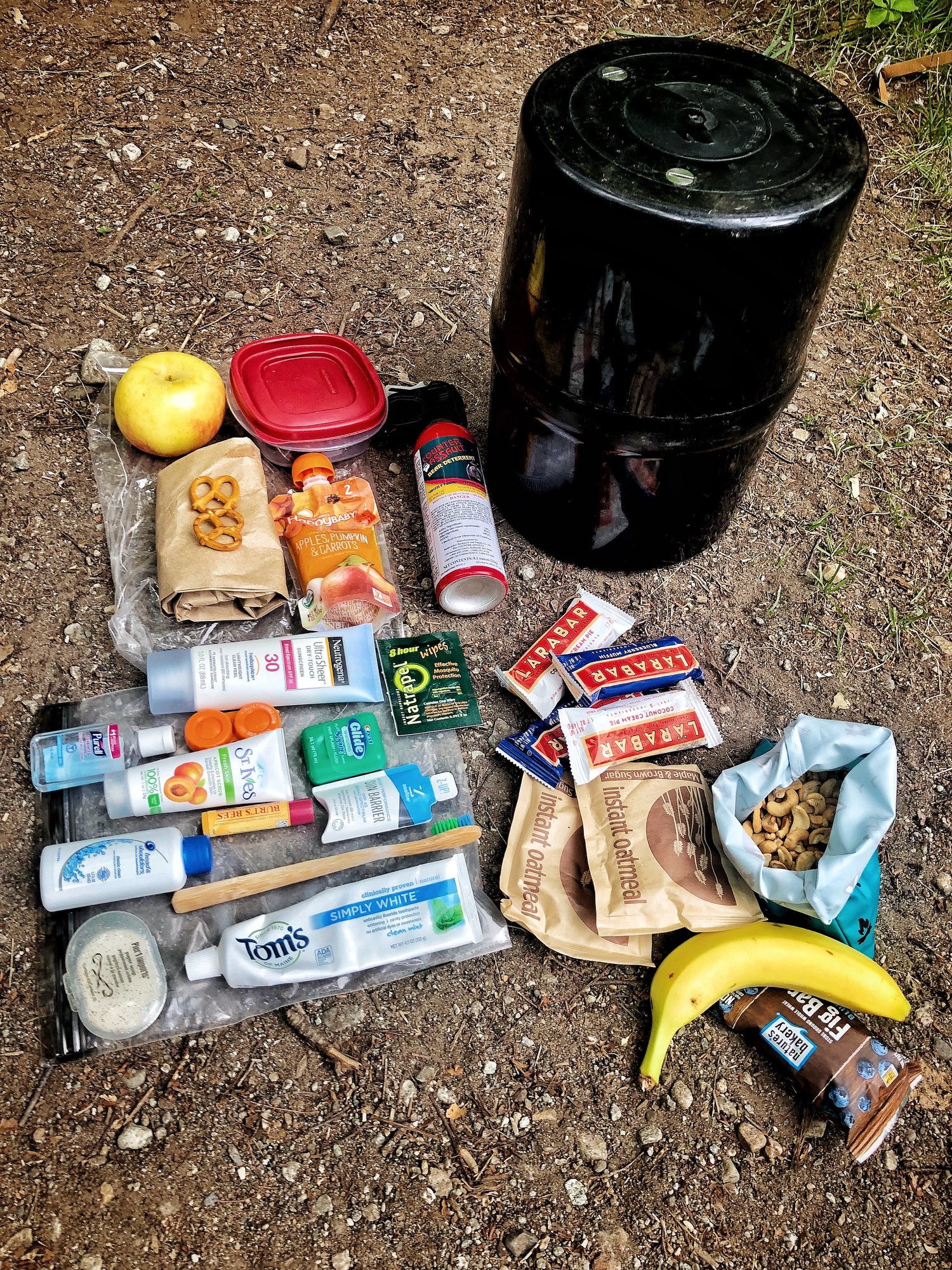
Packing the proper gear for a hike is very important, and you should be prepared to encounter all conditions. See our recommended packing list and safety tips.
Plan Ahead and Prepare
Weather forecasts and conditions can and do change quickly. Check the current National Weather Service Forecast, and be prepared for the forecasted conditions, or change your plans.
-
Park in designated parking areas at trailheads: Memorial Day is Monday May 27th, marking one of the busiest weekends in the Adirondacks. Plan for busy trailheads and limited
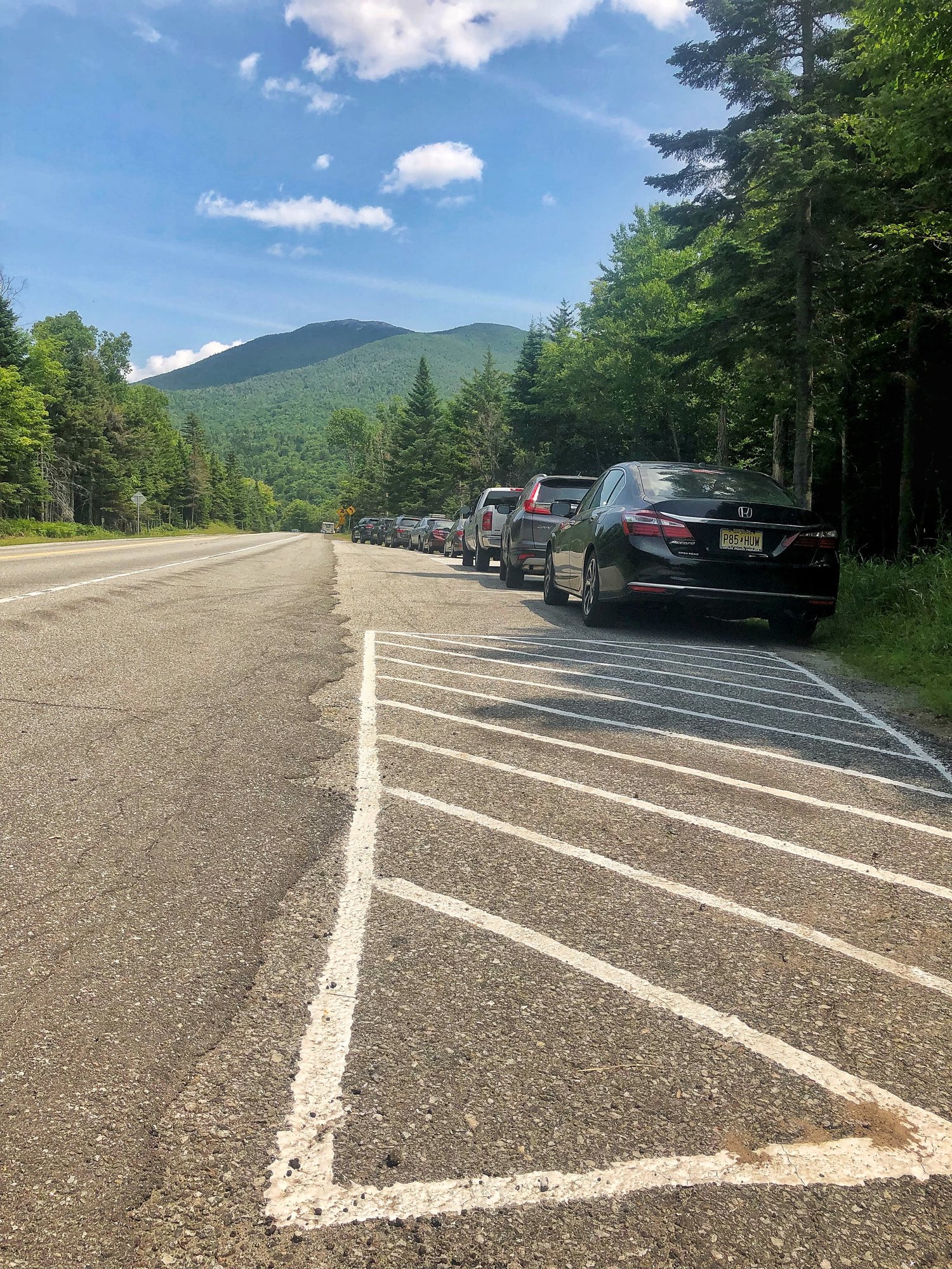 parking. Parking areas fill up quickly and early. Please avoid parking on the shoulder of busy highway roads for safety purposes. Be aware of visitors crossing roads. Do not block driveways, roadways, or roads from emergency vehicles or residents. parking. Parking areas fill up quickly and early. Please avoid parking on the shoulder of busy highway roads for safety purposes. Be aware of visitors crossing roads. Do not block driveways, roadways, or roads from emergency vehicles or residents.
-
Temperature variances: Temperatures at the trailhead will be significantly warmer than temperatures at the summit. Pack extra non-cotton, wind protectant layers, and be sure to use them once exposed or feeling colder to help prevent hypothermia.
-
Black Flies: The transition to spring means black fly season. Wear clothing that fully covers your body, use bug spray where you are not protected, and bring/wear a bug net to protect yourself from black flies. Wear light-colored clothing. Flies are attracted to dark colors.
-
Bear Canisters: Bear resistant canisters are the most effective means for preventing bears from obtaining food while you are camping. Black bears in the High Peaks Wilderness have regularly defeated bear resistant canisters made of clear plastic. Choose a dark coated bear canister where food is not visible inside. The use of bear-resistant canisters is required for overnight users in the High Peaks Wilderness between April 1 and November 30. All food, toiletries and garbage must be stored in bear-resistant canisters.
Practice Leave No Trace
Follow proper trail etiquette to maintain minimal impact on the  environment and the natural resources of the Adirondacks, as well as ensure an enjoyable outdoor experience for all visitors by following the Seven Principles of Leave No Trace. environment and the natural resources of the Adirondacks, as well as ensure an enjoyable outdoor experience for all visitors by following the Seven Principles of Leave No Trace.
Dispose of Waste Properly (Principle #3)
- As more people hit the trails this holiday weekend, more waste is produced and left behind. Follow these trail etiquette tips on how to properly dispose your waste to minimize your impact on the trail and other users.
- Use bathroom facilities if available, and go before you hit the trail. Check the location of pit privies along your planned route in case you have to use the bathroom throughout your trip.
- If privies are not availble, know how to dig a cathole. Catholes ensure your waste is not seen or smelled by others on the trail. They also give your waste the best possible chance of decomposing and not spreading bacteria or diseases to wildlife. Learn how to dig and use a cathole.
Respect Wildlife (Principle #6)
-
If you care, leave it there! Do not disturb or feed fawns and other young wildlife. Feeding can create dependence on humans and increase disease in wildlife. This includes food scraps along trails such as orange peels and apple cores. Carry out all food scraps.
Be Considerate of Other Visitors (Principle #7)
- Be courteous of others. Plan for busier trails this holiday weekend. Be courteous of others while recreating regardless of their activity, speed, or skill level. Hike in single file, especially when approaching other hikers. Stay to the right and pass on the left when safe and appropriate. Allow faster hikers to pass. When approaching other hikers from behind, politely let them know of your presence and desire to pass.
General Conditions/Notices
Learn the conditions you will encounter from Adirondack Backcountry Information.
All
-
Travel: Check NY511 for road closures and conditions.
-
Fire Danger: Low throughout the remainder of the Adirondacks.
- Fire danger rating can change daily in the spring. Check the fire danger map for daily updates.
-
Biting Insects: Black flies and mosquitoes have emerged heralding “bug season" in the Adirondacks. Follow these steps to minimize the nuisance of biting insects:
- Wear light-colored, long sleeve shirts and long pants.
- Tuck shirts into pants, button or rubber band sleeves at the wrist, and tuck the bottom of pant legs into your socks.
- Pack a head net to wear when insects are thick.
- Use an insect repellant with DEET, follow label directions.
- Spring in the Adirondacks:
- Mud and water in the lower to middle elevations

- Snow and ice in the upper middle to high elevations
- Check spring recreation tips for a safe and enjoyable outing while minimizing impacts on natural resources and trails.
-
Weather: Check the National Weather Service or NY Mesonow for current conditions and forecasts for the location where you plan to recreate.
-
Water Levels: Rains (and melting snow in the High Peaks Region) are keeping water levels in rivers and streams high and flowing fast. Check the USGS Current Water Data for New York for stream flow of selected waters.
-
Water Temperatures: Water temperatures are very cold.
- Personal Flotation Devices (PFDs aka lifejackets) are strongly recommended to be worn by all anglers, boaters, and paddlers.
- People immersed in cold waters can lose the ability to think clearly and move quickly after only a short time in the water.
- Anglers fishing from shore or wading should wear a personal flotation device.
-
Seasonal Access Roads:
- Many seasonal access roads are open while many others remain closed for mud season.
- Closed roads will reopen after the frost has thawed, the roads are dry, and any necessary repairs and maintenance are completed.
- Check the Specific Notices below and the Adirondack Backcountry Information web pages to learn what access roads are open.
- Seasonal access roads are dirt and gravel roads that can be rough.
- Four-wheel drive SUVs, pick-up trucks, and other high clearance vehicles are recommended for driving on these roads.
- Roads may be narrow – use caution, drive slowly, and watch for oncoming vehicles.
Hikers and Campers
-
General Information
-
Muddy Trail Advisory: DEC has issued the annual Spring Muddy Trail Advisory
- Please protect high elevation trails and vegetation and postpone hikes on trails
 above 2,500 feet until these high elevation trails have dried and hardened. above 2,500 feet until these high elevation trails have dried and hardened.
- Snow and ice are currently melting on high elevation trails.
- Steep trails with thin soils can be dangerous to hike and are susceptible to erosion; and sensitive alpine vegetation is easily damaged.
- Choose any of the numerous trails under 2,500 feet to hike until the advisory is lifted.
- Trail Conditions:
- Mud and water are present on most trails – protect trails and trailside vegetation by walking through mud and water, not around it.
- Water levels are high - low water crossings may be problematic or impossible to cross.
-
Bear Resistant Canister:
- The use of bear-resistant canisters is required for overnight users in the Eastern High Peaks Wilderness between April 1 and November 30.
- All food, toiletries and garbage must be stored in bear-resistant canisters.
- DEC encourages the use of bear-resistant canisters and other practices to avoid negative encounters with bears throughout the Adirondacks.
-
Mountain Summits: Please avoid high elevation mountain summits while the Muddy Trail Advisory is in effect.
Bikers
-
General Information
-
Trail Conditions
- Most trails are dry and rideable.
- Don’t’ use muddy trails, they are easily rutted and damaged through use.
- If you are leaving tracks, turn back.
-
E-bikes: Electric powered bikes are prohibited on all bike trails on the Forest Preserve.
Boaters and Paddlers
-
General Information
-
Conditions
- Water levels are high and water temperatures are cold
- Personal Flotation Devices (PFDs aka lifejackets) are strongly recommended to be worn by all anglers, boaters, and paddlers.
- People immersed in cold waters can lose the ability to think clearly and move quickly after only a short time in the water.
-
Boat Launches: Due to high waters DEC is still unable to install docks at some boat launches. Docks have been installed at the following boat launches:
- Chateaugay Lake
- Ticonderoga (Lake Champlain) half the docks
- Mossy Point (Lake George) half the docks
- Second Pond (Saranac Chain of Lakes)
- Upper Saranac Lake
- Tupper Lake
- Long Lake
- Raquette River
Anglers
-
General Information: Fishing
- Water levels remain high due to frequent rain.
- Wear proper footwear and use a hiking stick with a carbide tip to access the water.
- Water temperatures are cold.
- Anglers should wear a PFD as a precaution.
- A person falling into the water could quickly lose the ability to keep their head above water.
- Anglers new to brook trout fishing should look to the Guide to Brook Trout Fishing in Adirondack Ponds for assistance.
Climbers
Recent Notices
Notices below reflect recent changes in conditions and recreation infrastructure work that DEC and its partners completed. Check the Backcountry Information for the Adirondacks for ongoing issues and more detailed information.
-
Saranac Lakes Wild Forest: Repairs have been completed on the Lake Placid Boat Launch, and it is open for boaters to use.
-
Debar Mountain Wild Forest: The Debar Meadows Road and the Debar Mountain Trailhead road are open for public motor vehicle use.
-
Perkins Clearing Conservation Easement Tract: All seasonal access roads are open, except for the access road to the Pillsbury Mountain Trailhead, which is closed due to a washout. Hikers can park in the gravel pit and walk 1.5 miles to the trailhead.
-
Essex Chain Lakes Complex:
- The following roads will open to public motor vehicle use Saturday morning:
- Chain Lakes Road North
- Drake’s Mill Road
- Cornell Road
- Deer Pond Road
- Chain Lakes Road South to the Outer Gooley Parking Area remains closed.
-
Kushaqua Conservation Easement Tract:
- The following roads are open for public motor vehicle use:
- North Branch Road
- Hunter’s Camp Road
- Aden Road
- Road 5-2
- Mountain Pond Road remains closed due to muddy conditions.
-
Boreas Ponds Tract: DEC will be working in June and July to provide additional access and recreational infrastructure.
- Gulf Brook Road will remain closed through the Memorial Day holiday weekend due to a significant washout on the road.
- When the road opens, motorists will be able to access the Fly Pond Parking Area on weekends only.
- Hikers, bicyclists, and horseback riders will be able to use the road during the week but must use caution in construction areas and obey all instructions from workers.
-
Blue Mountain Wild Forest: A new 2.2-mile spur trail connecting the 134-mile Northville-Placid Trail (NPT) to the hamlet of Long Lake in Hamilton County is open.
- The trail connects with the NPT approximately 1.9 miles south of Route 28N.
- The connection is marked with yellow trail markers and crosses Forest Preserve and town-owned lands.
- The trailhead is located in a gravel parking lot at the intersection of Route 30/28N, South Hill Road, & Pavilion Lane across from the Long Lake Post Office.
- The trail eliminates 1.5 miles of hiking on the shoulder of Route 28N.
-
Moose River Plains Wild Forest/West Canada Lakes Wilderness:
- Cedar River Road is open to the Cedar River Flow for public motor vehicle use.
- The Limekiln Lake – Cedar River Road will be opened from the Limekiln Lake entrance to just east of the Lost Ponds Trailhead at Campsite 39.
- The Otter Brook Road is open to the bridge over the South Branch Moose River.
- Beaver Lake Trailhead cannot be accessed by motor vehicles.
- The following roads or road sections remained closed to public motor vehicles:
- Limekiln Lake – Cedar River Road between the Cedar River entrance and Campsite #39
- Rock Dam Road
- Otter Brook Road at the bridge over South Branch Moose River
- Indian Lake Road
-
Santa Clara Conservation Easement Tract/Debar Mountain Wild Forest: The following seasonal access roads are open to public motor vehicle use:
- Madawaska Road
- Pinnacle Road
- Howe Access Road
- Four Mile Road
- Vanderwalker Road
-
Sable Highlands Conservation Easement Tract:
- Piney Ridge Road and D&H Road are open to public motor vehicle use.
- Both roads have some minor washouts, but should be passable by four-wheel drive SUVs, pick-up trucks, and other high clearance vehicles.
- There also some trees bent or hanging over the road.
- Drivers should use caution and proceed slowly.

-
High Peaks Wilderness:
-
Preventative Search and Rescue (PSAR): DEC forest rangers and assistant forest rangers will continue this pilot initiative this weekend to reduce the number of incidents in the Adirondack High Peaks region and help to ensure the public has an enjoyable and safe outdoor experience.
-
Garden Trailhead Parking Lot is Closed: Hikers can access the Garden Trailhead using the Town of Keene’s shuttle from Marcy Field. See the shuttle schedule and additional information.
-
Corey’s Road is open for public motor vehicle use.
- The Clear Pond Gate is open and Elk Lake Road is open for public motor vehicle use to the Elk Lake Trailheads.
-
Independence River Wild Forest: All gates to seasonal access roads have been opened, and the roads are available for public motor vehicle use.
-
Watson’s East Triangle Wild Forest: Bear Pond Road is open to public motor vehicles.
-
Croghan Tract Conservation Easement Tract: Main Haul Road, which also provides access to western portion of the Pepperbox Wilderness, is open to public motor vehicles.
-
Oswegatchie Conservation Easement Tract: All gates to seasonal access roads have been opened, and the roads are available for public motor vehicle use.
-
Black River Wild Forest: Loop Road (access to campsites along North Lake) is open for public motor vehicle use to the washout at Golden Stair Creek.
-
William C. Whitney Wilderness: Lake Lila Road is open for public motor vehicle use. Do not trespass on private property along the road.
-
Wilcox Lake Wild Forest: Pumpkin Hollow Road is closed for mud season.
Highlighted Hike: Camp Santanoni Historic Area, Newcomb, NY
The Camp Santanoni Historic Area is a very unique location in the Adirondack Forest Preserve. It is considered one of the most sophisticated and distinguished of all of the surviving great camps in the Adirondacks. This National Historic Landmark was created in the late 19th and early 20th centuries by Robert C. and Anna Pruyn, serving as a place to entertain guests and find refuge from city life. Today, the area is a popular day hike destination during summer months, as well as a cross country skiing destination in the colder months.
Newcomb Lake Road Trail is a 5-mile gravel former carriage road that extends from the  trailhead at the Gate Lodge to Newcomb Lake. The trail ascends 350 feet in 3.0 miles and then descends 250 feet to the Main Complex on Newcomb Lake. The trail passes through the Farm Complex 0.7 miles from the trailhead. trailhead at the Gate Lodge to Newcomb Lake. The trail ascends 350 feet in 3.0 miles and then descends 250 feet to the Main Complex on Newcomb Lake. The trail passes through the Farm Complex 0.7 miles from the trailhead.
Santanoni-Lake Harris Trail extends 1.75 miles along the north shore of Lake Harris connecting the Gate Lodge Complex and DEC's Lake Harris Campground.
The Moose Pond Horse Trail leaves the Newcomb Lake Road Trail and enters the High Peaks Wilderness approximately 2.5 miles from the trailhead and the Newcomb Lake-Moose Pond Trail leaves the trail approximately 1 mile before the Main Complex.
The Newcomb Lake-Moose Pond Trail connects with the Newcomb Lake Trail to form a 4.2-mile loop trail around the Newcomb Lake which passes through the Main Complex. The trail has numerous ascents and descents of various heights but no more than 125 feet
The 236-acre Adirondack Interpretive Center (AIC) sets on the shores of Rich Lake and Rich Lake outlet. AIC is managed by the SUNY College of Environmental Science and Forestry (ESF). In addition to the trail system, AIC has an interpretive center with naturalists and holds many programs regarding the cultural and natural history of the Northern Forest.
Camp Santanoni Historic Area is accessed from the Gate Lodge Parking Area, located on Newcomb Lake Road, off NY Route 28N. 43.9737°N, 74.1650°W.
View Map.
|

