|
Have a safe and enjoyable outdoor recreational experience on the lands and waters of the Adirondacks. Properly plan and prepare for your outdoor adventure. Minimize the impact on the mountains and forests, rivers and brooks, ponds and lakes, and the wildlife of the Adirondacks.
Check the Backcountry Information for the Adirondacks web pages for more detailed information on access, outdoor recreation infrastructure, and conditions for those planning to recreate in the Adirondacks. This bulletin provides only the most recent notices.
Emergency Situations: If you get lost or injured, keep calm and stay put. If you have cell service, call the DEC Forest Ranger Emergency Dispatch, 518-891-0235.
Check snow amounts and mountain weather conditions before heading out this weekend.
Packing the proper gear for a winter hike is very important, and you should be prepared to encounter all conditions. See our recommended packing list and winter safety tips.
Watch a video about winter hiking safety tips.
View a video about snowmobile safety.
Plan Ahead and Prepare
Weather forecasts and conditions can and do change quickly. Check the current National Weather Service Forecast, and be prepared for the forecasted conditions, or change your plans.
-
Spring-like temperatures: Temperatures at the trail head will vary from temperatures at your destination. Higher elevations and exposed summits can have significantly colder temperatures than the base of the mountain. Pack extra non-cotton, wind protectant layers and be sure to use them once exposed or feeling colder to help prevent hypothermia.
-
Fluctuating Weather Conditions: Weather 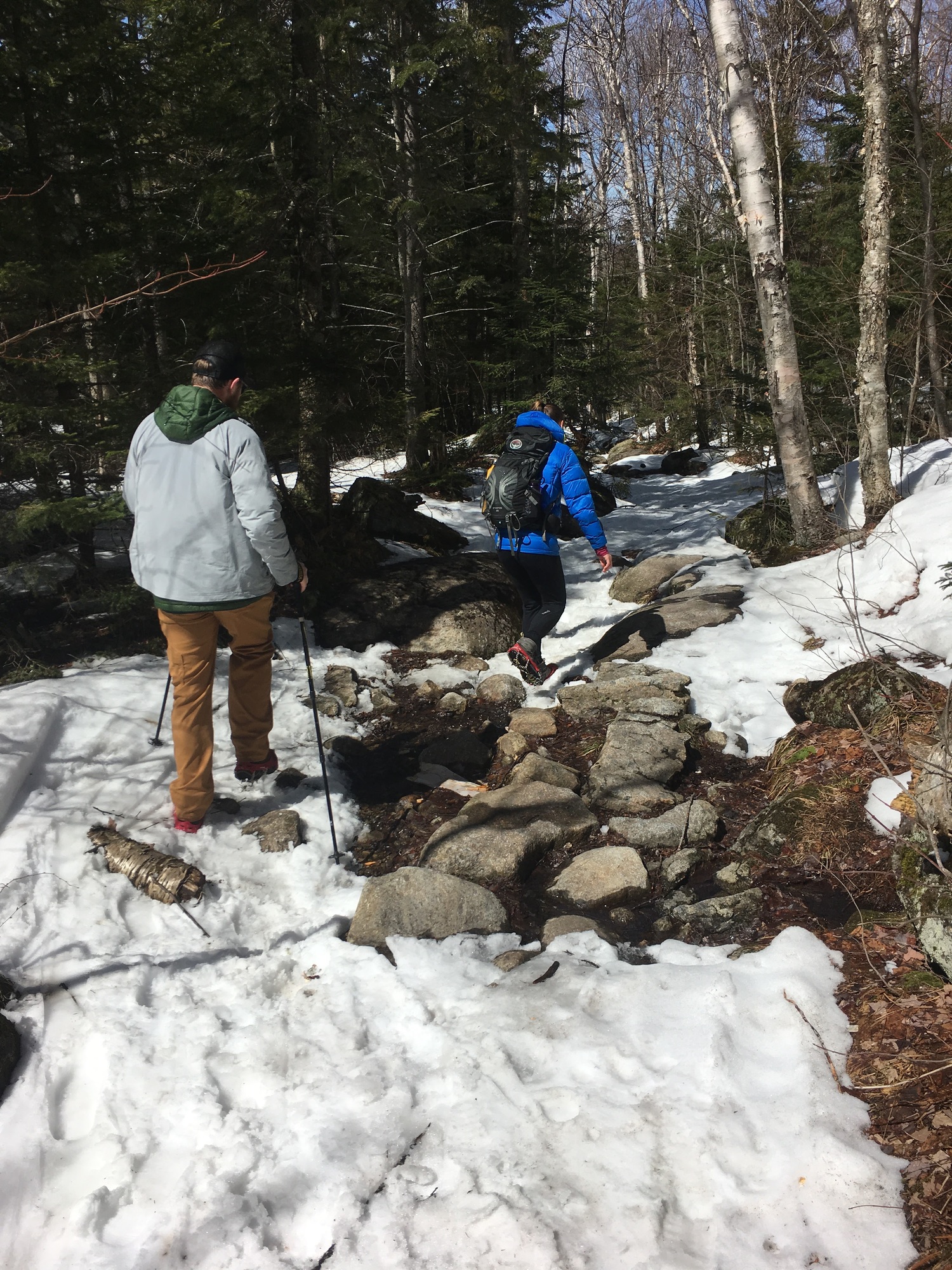 conditions can fluctuate widely and quickly during late winter/early spring. Rain, sleet, freezing rain, snow, and even thunderstorms can occur. Check the local weather reports and choose an alternate trail or date if weather is unfavorable. Carry rain gear and other equipment to prepare for various weather conditions. Monitor weather while hiking and return to your vehicle if conditions worsen. conditions can fluctuate widely and quickly during late winter/early spring. Rain, sleet, freezing rain, snow, and even thunderstorms can occur. Check the local weather reports and choose an alternate trail or date if weather is unfavorable. Carry rain gear and other equipment to prepare for various weather conditions. Monitor weather while hiking and return to your vehicle if conditions worsen.
-
Carry crampons. Due to the warming weather this week, icy conditions will be present once again, especially on exposed bedrock and rocky summits. Micro spikes are suitable on level ground but not on trails on slopes. Crampons are recommended.
-
Expect high water levels and swift currents on rivers and streams. Melting snow and rain raise water levels. High fast-moving waters make stream crossings on trails dangerous and even impossible. Heed high water warnings and find a safer alternate route or trip. Do not try to cross through cold, high, fast flowing waters.
-
Trout Season: Trout season opens Monday, April 1st. Use caution when wading through high, swift waters. Currents will be strong and water will be cold. Always bring a flotation device and use a walking stick for balance in waterways. Wear warm layers underneath waterproof waders and boots to prevent hypothermia. Check area conditions before you go.
Practice Leave No Trace
Follow proper trail etiquette to maintain minimal impact on the  environment and the natural resources of the Adirondacks, as well as ensure an enjoyable outdoor experience for all visitors by following the Seven Principles of Leave No Trace. environment and the natural resources of the Adirondacks, as well as ensure an enjoyable outdoor experience for all visitors by following the Seven Principles of Leave No Trace.
-
LNT: Fishing
- Plan and prepare ahead by knowing area fishing regulations, weather conditions, and current water levels and temperatures.
- Be considerate of other anglers when casting within proximity to one another.
- Always pick up fishing line, lures, and other waste from the shoreline and trails.
- Fun Fact: According to the US Forest Service, monofilament fishing line takes 500 years to photodegrade. Fishing line can be an entanglement hazard to both wildlife and people swimming or spending time on the shoreline.
- Avoid transferring fish from one water body to another.
General Conditions/Notices
Learn the conditions you will encounter from Adirondack Backcountry Information.
All
-
Travel: Check NY511 for road closures and conditions.
-
Winter Conditions in the Adirondacks: While spring may have arrived on the calendar – and spring conditions may be present in areas to the south – winter conditions remain present across the Adirondacks.
-
Weather: Forecast calls for above freezing temperatures and rain, followed by wet snow.
- Daytime high temperatures are forecast to be in the 40s and 50s.
- Night time lows will be below freezing in the northern Adirondacks and the higher elevations.
- Night time low temperatures will be above freezing in the lower elevations of the southern Adirondacks.
- Rain on Saturday will change over to wet snow on Sunday in the northern Adirondacks and higher elevations.
- Rain showers are forecast both days in the lower elevations of the southern Adirondacks.
- This is a general forecast and may change. Check the National Weather Service for current forecasts for the location where you plan to recreate.
-
Snow Cover: Snow depths range from 15 to 30 inches across most of the Adirondacks.
- Snow is less deep around the very western, very eastern, and a large part of the southern Adirondacks.
- There is little to no snow in the very northeastern corner of the Adirondacks.
- Open areas in the lower and middle elevations – especially those on south facing slopes – have little to no snow.
- Snow is deeper in the higher elevations; snow is 7 to 8 feet deep above 3,000 feet in the High Peaks region.
- Above freezing temperatures and rain will cause snow to melt and snow depths to decrease through the weekend.
- The National Weather Service NERFC Snow Page provides maps depicting current snow depths and forecasts.
- Ice on Waterbodies:
- Lakes and ponds remain frozen with up to 2 feet of ice.
- Ice may be covered with slush and water.
- Always check the thickness of ice before traveling across it.
- Avoid ice over running water, near inlets & outlet and near boathouses & docks - especially those with "bubblers" or other ice prevention devices.
- Remember, ice that holds snow may not hold the weight of a person.
-
Be safe on the ice, especially when ice fishing.
Hikers/Skiers/Snowshoers
-
General Information
- Trail Conditions:
- Most trails are covered in deep snow which will soften with the rain and warm temperatures.
- Lesser used trails may be covered with deep “unbroken” snow.
- Snowshoes should be used on all hikes where snow depths exceed 8 inches.
- Post-holing can occur even on heavily compacted snow as the snow warms, softens, and melts.
- Open areas in the lower to middle elevations may have little to no snow, however, ice may be present on any trail.
- Carry trail crampons, and steel-tipped hiking poles on all hikes and use when conditions warrant.
- Traveling through snow takes more time and energy than hiking on bare ground – especially when breaking trail through deep snow.
- Water levels will rise in rivers, streams, and drainages due to melting snow and rain. Low water crossings may be problematic or impossible to cross.
- Blowdown (fallen trees, limbs, and branches) may be present on trails. Plan for hikes to take longer.
-
Designated Snowmobile Trails:
- Watch and listen for snowmobiles when skiing or snowshoeing on designated snowmobile trails.
- Move off the trail to allow snowmobiles to safely pass.
-
Mountain Summits: Temperatures will be much colder, winds will be stronger, ice will be present, and snow will be deeper. Check the National Weather Service Mountain Point Forecasts for selected summits.
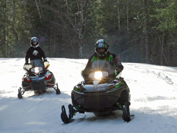
Snowmobilers
-
General Information: Snowmobiling
- Trails Conditions:
- Trails will soften through the weekend.
- Snow depths are shallow in the low elevations around the edge of the region and much of the south and southeastern portion of the Adirondacks.
- Check with local snowmobile clubs to determine status and condition of trails.
- New York State Snowmobile Association Interactive Trail Map
-
Safety:
- Watch for skiers and snowshoers using snowmobile trails - slow down to safely pass.
Ice Anglers
-
General Information:
-
Trout Season: Monday, April 1st, is opening day for trout fishing, and the Adirondacks provide some of the finest backwoods brook trout fishing in the northeast.
- Rivers and brooks in the southern Adirondacks and the lower elevations will be open but may have ice and snow on the banks.
- Wear proper footwear and use a hiking stick with a carbide tip to access the water.
- Currently, rivers and brooks in much of the Adirondacks are dangerous or impossible to access due to snow and ice.
- Water temperatures are extremely cold.
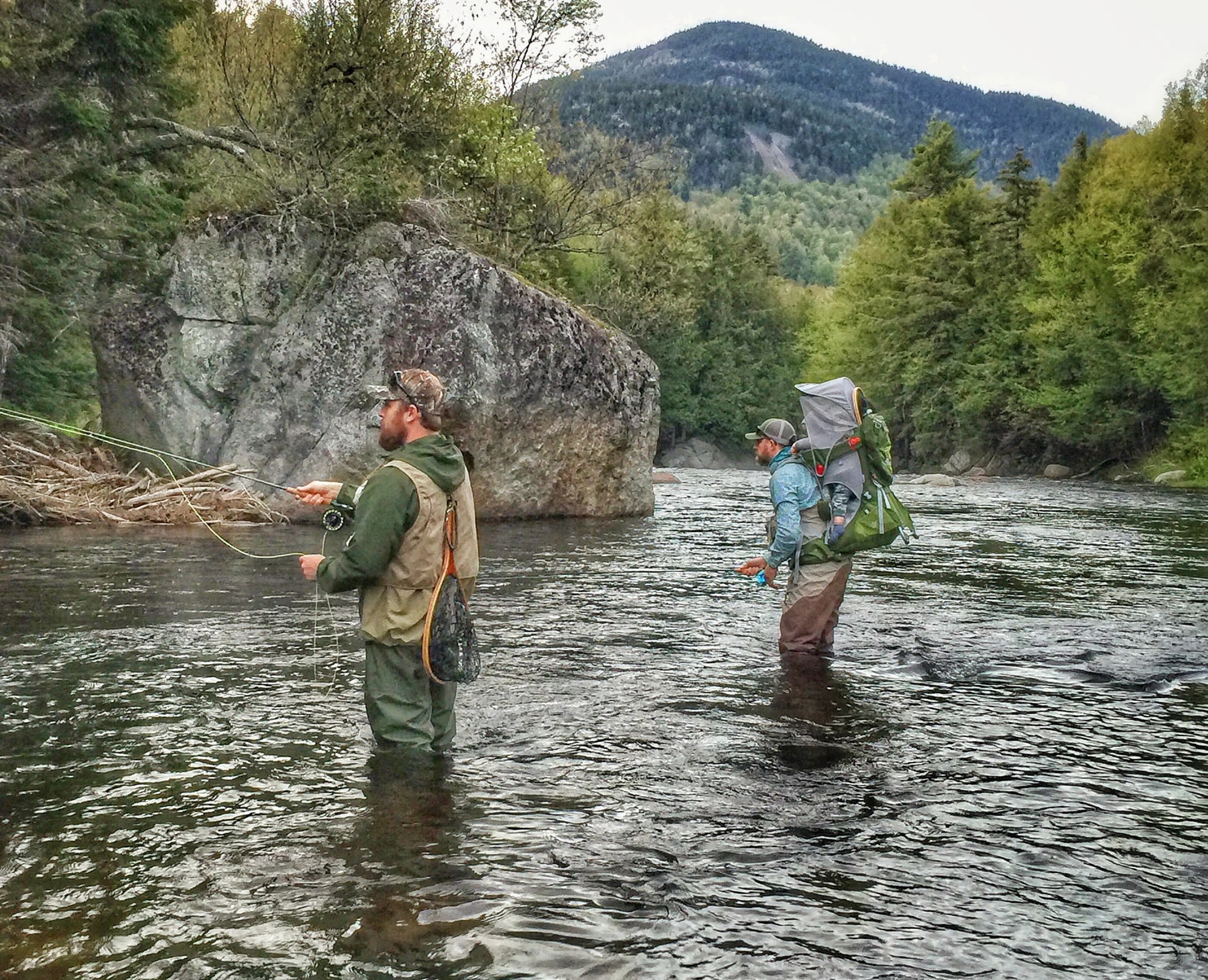
- Anglers should wear a Personal Flotation Device (PFD) as a precaution.
- A person falling into the water could quickly lose the ability to keep their head above water.
- Water levels will rise as snow melts and may even rise significantly from morning to afternoon as the day warms. Monitor water levels to ensure your safety.
- Anglers new to brook trout fishing should look to the Guide to Brook Trout Fishing in Adirondack Ponds for assistance.
-
Ice Shanties: You can take Ice fishing shanties on and off the ice when in use, but you cannot leave them empty on the ice.
-
Safety: Be safe on ice.
Climbers
Recent Notices
Notices below reflect recent changes in conditions and recreation infrastructure work that DEC and its partners completed. Check the Backcountry Information for the Adirondacks for ongoing issues and more detailed information.
-
High Peaks Wilderness:
- 67 inches (170 cm) of snow at the stake at 2,750 feet (838 m) elevation.
- 7 to 8 feet (215 to 245 cm) of snow above 3,000 feet (914 m) elevation.
- The use of snowshoes or skis is required on all trails.
- South Meadow Lane, Marcy Truck Trail, and the ski trails are in good condition for skiing despite the loss of some snow depth prior to the weekend.
- Snow cover on foot bridges may be above the handrails. Use caution when crossing.
- Garden Trailhead Parking Lot Closed Spring and Summer 2019
- The parking lot at the Garden Trailhead – one of the main access points to the eastern High Peaks Wilderness – will be closed during the spring and summer of 2019 due to the replacement of the Johns Brook Bridge.
- Work on installing the replacement bridge will begin as soon as weather and road conditions allow and is expected to last through the summer.
- Once work begins, no vehicles or pedestrians will be able to pass the bridge to access the parking lot until the work is complete.
- During this time, the only way to access the Garden Trailhead is by using the shuttle from the Marcy Field.
- The shuttle will use a detour across private property that is closed to the public.
- Driving, biking, or walking on the detour road is prohibited – violators will be charged with trespassing.
- Public use of the private roadway could lead to loss of access by the shuttle and no means of accessing the trailhead.
- The shuttle schedule and additional information is provided by the Town of Keene.
- Lake Colden Caretaker Report
-
Snow Bulletin:
- This past weekend’s winter storm brought 6-18 inches of new wet snow.
- High winds were associated with the storm.
- Expect wind slabs to have formed on leeward slopes and significantly more amounts in deposit zones, such as gullies.
- The current snow conditions have created a great bed surface for snow to slide on.
- Backcountry downhill skiers, snowboarders, and others who may traverse slides and other steep open terrain should be aware of avalanche risks on what to do to avoid triggering avalanches.
- There have been four skier triggered avalanches reported this winter in the High Peaks region – two included partial burial of skiers. All four occurred during or within a few days of a winter storm.
-
Kings Bay Wildlife Management Area: The gates for the road to Catfish Bay are closed due to muddy conditions. This WMA sets on the shores of Lake Champlain north of the Adirondacks.
-
Ausable Marsh Wildlife Management Area: The gate has been closed due to flooding on the road. This WMA sets on the shores of Lake Champlain in northeast corner of the Adirondacks.
-
Lake George Wild Forest: The Town of Fort Ann has closed Shelving Rock Road for mud season. Parking along Shelving Rock Road and at the gate is prohibited. Sleeping Beauty, Shelving Rock, and the Buck Mountain East Trailhead are not accessible while the road is closed.
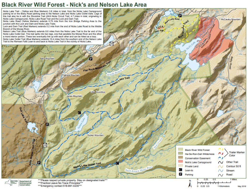
Highlighted Hike: Nicks and Nelson Lake Area, Old Forge, NY
The 127,135-acre Black River Wild Forest is located within the southwestern foothills of the Adirondack Forest Preserve and offers a broad spectrum of recreational opportunities, from snowmobiling near the adjacent communities of Old Forge and Otter Lake to hiking on foot trails in remote areas.
The following trail system originates from Nicks Lake Campground;
Nicks Lake Trail (Yellow and Blue Markers) is 3.8 miles in total and starts from the Nicks Lake Campground parking lot or the Bisby Road parking area to the Nelson Lake and Nicks Lake Outlet trails. Legs of this trail also tie in with the Shoreline Trail, Nicks Lake Road Trail, and the Lock and Dam Trail.
Shoreline Trail (AKA Nicks Circuit Trail) is a 4.7-mile loop. Portions of the Nicks Lake Trail and the Nicks Lake Outlet Trail are used to make the loop.
Nicks Lake Road (Yellow Markers) extends 0.75 mile from the Iron Bridge Parking Area to the junction with the Lock and Dam and Nicks Lake Trails
Lock and Dam Trail (Red Markers) extends 0.2 mile from the end of Nicks Lake Road to the Middle Branch of the Moose River.
Nelson Lake Trail (Blue Markers) extends 8.8 miles from the Nicks Lake Trail to the far end of the Nicks Lake Outlet trail. This trail splits into two legs, one that parallels the Moose River and the other a more interior portion. These two eventually link up with each other and can be hiked as a loop.
Nicks Lake Outlet Trail (Blue Markers) extends 10.4 miles from the southern end of the Nelson Lake Trail to the Remsen Falls Lean-to and back to Nicks Lake Trail in the vicinity of Nicks Lake.
View trail map.
Bisby Road/Nicks Lake Trailhead Parking Area: South of the hamlet of Old Forge on Bisby Road (Nicks Lake Trailhead). There is parking available for 2-3 vehicles (43.693191°N, 74.977980°W).
|

