|
Have a safe and enjoyable outdoor recreational experience on the lands and waters of the Adirondacks. Properly plan and prepare for your outdoor adventure. Minimize the impact on the mountains and forests, rivers and brooks, ponds and lakes and the wildlife of the Adirondacks.
Check the Backcountry Information for the Adirondacks web pages for more detailed information on access, outdoor recreation infrastructure, and conditions for those planning to recreate in the Adirondacks. This bulletin provides only the most recent notices.
Emergency Situations: If you get lost or injured, keep calm and stay put. If you have cell service, call the DEC Forest Ranger Emergency Dispatch (518-891-0235). Stay warm and dry by separating yourself from the wet ground with a thicker layer such as your pack. Protect yourself from the elements by building a shelter with items around you and in your pack. Use a space blanket for extra warmth.
More information on hiking safety and what to pack.
Muddy Trail Advisory: 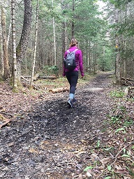 The harsh, long winter with its deep snow and deep frost has caused problems for high elevation trails, so the Muddy Trail Advisory remains in effect. Help avoid damage to hiking trails and sensitive high elevation vegetation by avoiding trails above 2,500 feet, particularly high elevation trails in the Dix, Giant, High Peaks, McKenzie Mountain, and Sentinel Range Wilderness areas in the northern Adirondacks. Avoiding these trails during the Muddy Trail Advisory helps to alleviate impacts to the trail tread and adjacent areas. Saturated, thin soils and steep grades combined, with hikers trying to get traction, lead to increased impacts to the trail corridors during the shoulder seasons. The harsh, long winter with its deep snow and deep frost has caused problems for high elevation trails, so the Muddy Trail Advisory remains in effect. Help avoid damage to hiking trails and sensitive high elevation vegetation by avoiding trails above 2,500 feet, particularly high elevation trails in the Dix, Giant, High Peaks, McKenzie Mountain, and Sentinel Range Wilderness areas in the northern Adirondacks. Avoiding these trails during the Muddy Trail Advisory helps to alleviate impacts to the trail tread and adjacent areas. Saturated, thin soils and steep grades combined, with hikers trying to get traction, lead to increased impacts to the trail corridors during the shoulder seasons.
Would you like your photo shared in our weekly bulletin? Send us your photos that represent current backcountry conditions in the Adirondacks. Send in your photos with your name and photo location/brief description to Info.R5@dec.ny.gov or simply tag #NYSDEC on Instagram.
Plan
Weather forecasts and conditions can and do change quickly. Check the current National Weather Service Forecast and be prepared for the forecasted conditions or change your plans.
-
Bear Canisters: The use of bear-resistant canisters is required for overnight users in the Eastern High Peaks Wilderness between April 1 and November 30. Black Bears in the Eastern High Peaks Wilderness have regularly defeated bear resistant canisters made of clear plastic. Choose a dark coated bear canister where food is not visible inside. In addition to storing all food, toiletries and garbage in a bear resistant canister as required by regulation, campers should:
- Store food, toiletries & garbage in a bear resistant canister away from the campsite or lean-to.
- Do not use a food hang for any reason - it is prohibited.
- Prepare food away from the campsite or lean-to, and prepare and eat food well before dark.
- Take food out immediately before preparation and/or eating.
- Take out only as much food as will be eaten.
- If approached by a bear, make noise and make all reasonable efforts to keep bears from obtaining food, but do not risk physical contact. Back away from the bear, but never run.
- Learn how to use a bear resistant canister.
-
Watch out for cyclists: Adirondack roadways are shared by all. Cyclists training for the annual Lake Placid Ironman in late July are utilizing Route 86 between Jay and Lake Placid, Route 73 between Lake Placid and Keene, and Route 9N between Keene and Jay as part of the training course. Please use caution and drive slowly, especially through the Cascade Lakes area and the Wilmington Notch where the road becomes very narrow and there is little to no shoulder. Vehicles should always be aware and keep an eye out for cyclists on all roads in the Adirondacks. Parking along the side of the road removes access to safe shoulders for cyclists who are sharing the roadways. Please park ONLY in designated parking areas along roadsides and at trailheads.
-
Biting Insects: "Bug Season" has begun in the Adirondacks. Now, until the end of summer, Black Flies; Mosquitos; Deer Flies and/or Midges (No-see-ums) will be present. Follow these steps to minimize the nuisance of biting insects:
o Wear light colored clothing.
o Wear long sleeve shirts and long pants.
o Pack a headnet to wear when insects are thick.
o Use an insect repellant with DEET, follow label directions.
Prepare
Properly prepare to better ensure a safe and enjoyable recreation experience.
-
Always prepare for an emergency situation. Trails are slippery this time of year due to mud. Unexpected weather can occur this time of year, and even simply taking a wrong turn are just a few possible situations that can occur when hiking. Prepare for the unexpected by researching your trip route ahead of time so you are able to clearly communicate your possible location with emergency responders. Leave your route itinerary with a friend or family member at home so they are able to also clearly communicate your possible location should you not arrive back on time. Have the emergency dispatch number in your phone and easy to find in case of an emergency. Always carry an emergency essentials kit, no matter the length or difficulty of hike. See above “emergency situations” section for what to include in your kit. Try to always hike with a friend for safety purposes, but also, great trips are also best shared with friends.
-
Parking along the side of the road removes access to safe shoulders for cyclists who are sharing the roadways. Please park ONLY in designated parking areas along roadsides and at trailheads: Prepare for busy trailheads and limited parking from now until the end of the fall months. Parking areas fill up quickly and early. Please avoid parking on the shoulder of busy highway roads for safety purposes. Be aware of visitors crossing roads. Do not block driveways, roadways or roads from emergency vehicles or local residents.
-
Longer, Hotter Days: Longer, hotter days are more frequent. Bring at least 1-2 liters of water on every trip - prepare to bring more water depending on length of trip and daytime temperature. Plan out water sources along your trip where you can refill your container using a water filter. Hydrating properly will allow for a more enjoyable experience and will help you avoid overheating or heat sickness on your adventure. Always bring UV protectant clothing, sunglasses, and Chapstick as well as plenty of sunscreen.
Practice Leave No Trace
 Follow proper trail etiquette to maintain minimal impact on the environment and the natural resources of the Adirondacks, as well as ensure an enjoyable outdoor experience for all visitors by following the Seven Principles of Leave No Trace. Follow proper trail etiquette to maintain minimal impact on the environment and the natural resources of the Adirondacks, as well as ensure an enjoyable outdoor experience for all visitors by following the Seven Principles of Leave No Trace.
- Minimize Campfire Impacts (Principle #5)
- Only use firewood bought within a 50-mile radius of camping destination to reduce to spread of invasive species.
- Only use dead and downed wood around campsite for kindling or firewood.
- Keep fires small and burn all wood and coals to ash. Put out campfires completely.
- Plan Ahead and Prepare (Principle #1)
- Be a more environmentally-friendly camper by using these packing and preparation tips:
- Bring reusable containers for storing leftovers to ensure no food goes to waste.
- Prior to your trip, re-pack any food you are bringing along in reusable containers.
- Reusable cooking utensils and reusable or recyclable dishes cut down on the amount of trash generated.
- Reusable mugs, cups or bottles that can easily be rinsed or washed cut down on plastic waste. If it's necessary to use plastic, remember to recycle those items.
- Consider using biodegradable/earth-friendly dish soap, sponges and water basins. Do your dishes at least 150 feet away from any body of water.
- Bring non-toxic sunscreen and bug spray that won't harm waters, plants and wildlife.
- Be Considerate of Other Visitors (Principle #7)
- Be courteous of others while recreating regardless of their activity, speed, or skill level. Hike in single file, especially when approaching other hikers. Stay to the right and pass on the left when safe and appropriate. Allow faster hikers to pass. When approaching other hikers from behind, politely let them know of your presence and desire to pass.
General Conditions/Notices
Learn the conditions you will encounter from Adirondack Backcountry Information,
Hikers and Campers
- Trail Conditions:
- Trails are muddy above 2,500 feet elevation. DEC’s Muddy Trail Advisory remains in effect. DEC advises hikers to avoid trails above 2,500 feet elevation in the High Peaks Region.
- Trails below 2,500 feet elevation are mainly dry. Expect to encounter mud and water in low areas, drainages and along water bodies.
- Avoid damaging hiking trails and sensitive trail side vegetation and habitats.
- Wear waterproof hiking boots and let them get dirty.
- Stay in the center of trails.
- Walk through mud and water.
-
Mountain Summits: Avoid trails above 2,500 feet in the High Peaks Region. Elsewhere, remember temperatures will be colder and winds will be stronger. Check the National Weather Service Mountain Point Forecasts for selected summits.
-
Bear Resistant Canisters: The use of bear-resistant canisters is required for overnight users in the Eastern High Peaks Wilderness between April 1 and November 30. All food, toiletries and garbage must be stored in bear-resistant canisters. DEC encourages the use of bear-resistant canisters and other practices to avoid negative encounters with bears throughout the Adirondacks.
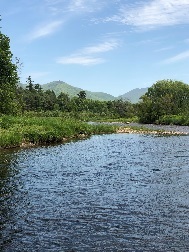
Boaters, Paddlers and Anglers
-
Water Temperatures: While water temperatures are warmer in shallow bays and shallow, small lakes and ponds, water temperatures remain cold in large, deep lakes, rivers and streams – even on warm days. Paddlers and boaters should wear a Personal Flotation Device (PFD, aka Life Jacket)! People immersed in cold waters can quickly become hypothermic and lose the ability to swim and keep their head above water. Anglers fishing from shore or wading in fast flowing streams should wear a PFD.
-
Water Levels: Water levels are within the average range or are below average levels for this time of year. See the USGS Current Water Data for New York for stream flow of selected waters.
Rock Climbers
-
Rock Climbing Route Closures: A number of rock climbing cliffs and routes in the eastern Adirondacks remain closed to climbing to allow peregrine falcons to nest and raise their young. Others have been reopened.
All
-
Fire Danger Rating: Low. Check the current fire danger map. Be safe with campfires.
-
Biting Insects: Bug Season in the Adirondacks is in full swing. Expect to encounter black flies, mosquitoes, and no-see-ums (biting midges) when outdoors. Follow these steps to minimize the nuisance of biting insects:
- Wear light colored clothing.
- Wear long sleeve shirts; tuck shirts into pants and button or rubber band sleeves at the wrist.
- Wear long pants and tuck the bottom of pant legs into your socks.
- Pack a headnet to wear when insects are thick.
- Use an insect repellant with DEET, follow label directions.
-
Seasonal Access Roads: All seasonal access roads designated for public motor vehicle use are open, except for Rock Dam Road in the Moose River Plains Complex. Seasonal access roads are dirt and gravels roads that can be rough. Four-wheel drive SUVs, pick-up trucks, and other high clearance vehicles are recommended for driving on these roads.
Specific Notices
Notices below reflect recent changes in conditions and recreation infrastructure work completed by DEC and its partners.
- High Peaks Wilderness:
- The lands of the Dix Mountain Wilderness are now part of the High Peaks Wilderness. DEC will be changing signs, web pages, and regulations to eliminate the Dix Mountain Wilderness and transition to the High Peaks Wilderness.
- DEC is seeking a trail crew supervisor and trail crew laborers to work in the backcountry of the High Peaks Wilderness as part of DEC High Peaks Trail Crew. The trail crew will spend the week camping out in tents (or a lean-to) or staying at one of DEC’s Interior Outposts. Most of the projects are located six miles from the nearest road and will require a strenuous hike with heavy pack to get to and from the work site. Tasks will include hardening tent sites, relocating privies, installing turnpiking, rock and drainage work, bridge building, and clearing blowdown. E-mail Info.R5@dec.ny.gov for a full job description and application instructions. Be part of the effort to maintain and protect the High Peaks Wilderness.
- The harsh, long winter with its deep snow and deep frost has caused problems for high elevation trails. The Muddy Trail Advisory remains in effect. Help avoid damage to hiking trails and sensitive high elevation vegetation by avoiding trails above 2,500 feet, particularly high elevation trails in the Dix, Giant, High Peaks, McKenzie Mountain, and Sentinel Range Wilderness areas in the northern Adirondacks.
- Gulf Brook Road is open to public motor vehicles to Fly Pond Gate (Parking Lot #8 on Interim Access Plan Map) which is approximately 3.2 miles from Blue Ridge Road, 2.5 miles from LaBier Flow, and 3.5 miles from Boreas Ponds. The road is in very rough shape after the long, hard winter – four-wheel drive SUVs, pick-up trucks, and other high clearance vehicles are recommended. DEC is developing plans to address these concerns.
- Mr. Van Lean-to on the Mr. Van Ski Trail has been repaired and can be used.
- Blowdown has been cleared from the Phelps Trail in Upper Johns Brook Valley.
-
Lake Flower Boat Launch: The boat launch is open but due to a clean-up project removing contaminated sediments from Lake Flower’s Pontiac Bay, no parking is available on site. Alternate parking is available for vehicles with boat trailers.
-
Independence River Wild Forest/Big Moose Conservation Easement Tract: The Stillwater Mountain Fire Tower will be closed to the public on Tuesday, June 18, while the Friends of Stillwater Fire Tower make repairs to its roof.
-
Blue Mountain Wild Forest (Township 19 Conservation Easement Tract): O'Neill Flow Road is open to public motor vehicle access.
-
Kushaqua Conservation Easement Tract: North Branch-Hays Brook Road and Mud Pond Road are open to public motor vehicle access.
- Moose River Plains Complex:
- Rock Dam Road remains closed to public motor vehicle access.
- Five Ponds Wilderness:
- A ten-mile section of the Oswegatchie River from High Falls downstream to the Inlet Hand Launch (Inlet Road) has numerous fallen trees across the river which may make passage difficult. Paddlers should portage around downed trees whenever possible.
- An 800-foot portion of the High Falls Loop (part of the Cranberry 50) has been rerouted to avoid a dangerous log crossing of a beaver dam. The new route has been signed and blowdown has been removed. It is located approximately 0.6 mile east of High Falls.
-
Saranac Lakes Wild Forest: The Adirondack Park Agency has released the Final Draft Unit Management Plan (UMP) for the Saranac Lakes Wild Forest for public review for compliance with the Adirondack Park State Land Master Plan. Based on public comments, DEC has made changes to the proposals contained in the Public Draft UMP (PDF).
-
Essex Chain Lakes Complex: Access to the western portion of the Complex, including the Deer Pond Parking Area, the Fifth Lake MAPPWD route, and the campsites along Cornell and Deer Pond Cornell Roads, will be closed to public use and motor vehicle access, beginning at sunset Sunday, July 22.
- The closure will remain in effect until the end of August.
- DEC is replacing three motor vehicle bridges, one each on Woody’s Road, Cornell Road, and Deer Pond Road, to facilitate safe passage along these corridors for the future.
-
Ha-De-Ron-Dah Wilderness:Beaver activity on the inlet to Middle Branch Lake has flooded a small section of the Middle Branch Lake Trail. A short detour is necessary to pass through this section of trail.
-
Jay Mountain Wilderness: Blowdown has been cleared from the Jay Mountain Trail.
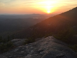
Highlighted Hike- Mt. Severance, Schroon Lake, NY
Mt. Severance is part of the Hoffman Notch Wilderness and is located in the Town of Schroon Lake. The Trail extends 1.2 miles one way and ascends 790 feet from the trailhead to the summit of the mountain. The summit provides a scenic view of Schroon Lake and Pharaoh Lake Wilderness. The trail travels under the Northway (I-87) before ascending the mountain.
Trail Map (PDF)
Mt. Severance Trailhead Parking Area is located on the west side of Route 9, 0.5 mile south of Exit 28, opposite Alder Meadow Road. (43.8627° N, 73.7548° W).
|

