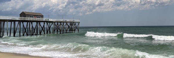
 Belmar Beach. Photo Source: Amber Mallm
Monmouth County Environmental Newsletter: Summer 2022
|
|
|
|
Having trouble viewing this email? View it as a Web page.
|
|
|
|
Spotted Lanternflies Are Back
 Photo Source: Oxford University Press on behalf of Entomological Society of America 2021
Spotted Lanternflies were the talk of the summer and fall months last year, and now they’re back and more relentless than ever. Spotted Lanternflies will be in their nymph stage from May to late July. They will then grow to be the red and grey spotted adults until late September when they lay their eggs. It is important to know what the insect looks like throughout each life stage, and to be educated on how to get rid of them.
The New Jersey Department of Agriculture recently identified 13 counties as “Quarantine Areas” with confirmed Spotted Lanternfly populations; Burlington, Camden, Essex, Gloucester, Hunterdon, Mercer, Middlesex, Monmouth, Morris, Salem, Somerset, Union, and Warren County. If you are leaving a quarantine zone, the State asks that you follow a checklist to examine all belongings to ensure no adult, nymph, or eggs are left on your items. Spotted Lanternflies are known to hitchhike on many surfaces, so the hope is to help stop the spread to areas where there are currently no confirmed populations. The checklist can be found on the State of New Jersey Department of Agriculture website.
Farm Activities All Summer Long
West End Farmer's Market. Photo Source: Grown In Monmouth
It’s farmers' market and pick-your-own season! Get delicious seasonal fruits and vegetables at markets around Monmouth County. From pick-your-own berries to cut your own flowers, it is always fun to see food come straight from the farms to our tables. A directory listing all markets, pick-your-own, farm stands, and more is located on the Grown In Monmouth website.
|
|
Upcoming Environmental & Outdoor Events in Monmouth County:
- Every Mon., Wed., Fri., in August, 11 a.m. - 12 p.m., Seining along Sandy Hook Bay at Bayshore Waterfront Park, Middletown, NJ
- Every Wed., Fri., Sat., Sun., in August, 2 p.m. - 5 p.m., Boat Tour of the Manasquan Reservoir at the Manasquan Reservoir in Howell, NJ
-
Every Tues. in August, 11 a.m. -12 p.m., Tidal Tuesdays- Seining at Fisherman’s Cove, Manasquan, NJ
-
Every Thurs. in August, 11 a.m., Enviro-Quest at multiple Monmouth County Parks
-
Every Thurs. in August, 11 a.m. -12 p.m., Life in a Freshwater Pond, Freneau Woods Park, Aberdeen, NJ
- Aug. 12, 9 -10 a.m., Butterfly Walks, Deep Cut Gardens, Middletown, NJ
-
Aug. 10 -11 a.m., Pollinator Garden Tour, Manasquan Reservoir Environmental Center, Howell, NJ
-
Aug. 12, 28, 10 a.m., 6:30 p.m., 9 a.m., Naturalist Walk at Winter Run Activity Center, Howell, NJ
-
Aug. 25, 7 -8 p.m., Nature Lecture Series: Box Turtles of Monmouth County at Freneau Woods Park Visitor Center, Aberdeen, NJ
- Aug. 27 & 28, 12 -2 p.m., Potato Harvest, Historic Longstreet Farm, Holmdel, NJ
- Aug. 30, 3 -5 p.m., Wingin’ It- Summer Bird Walk, at Horeshoe Cove, Sandy Hook, Middletown, NJ
- Sept. 6, 9 a.m., The Casual Birder at Fisherman's Cove Conservation Area in Manasquan, NJ
|
|
|
Next Steps for Communities Surrounding Naval Weapons Station (NWS) Earle

In June 2022, the Monmouth County Division of Planning released the Next Steps To Compatibility Planning Study, which was funded by a grant from the Department of Defense's Office of Local Community Cooperation The study is a follow-up to the 2017 Naval Weapons Station (NWS) Earle Joint Land Use Study. The plan focuses on the five towns surrounding Naval Weapons Station (NWS) Earle: Colts Neck, Howell, Middletown, Tinton Falls, and Wall, although the study's findings are applicable to other communities in the area. The plan offers a toolbox of land use and zoning options, and planning recommendations, policies and regulations to guide civilian land use decisions that are compatible with the ongoing operations of the military base and help protect the public’s health, safety, and welfare. You can view the study on on the Monmouth County Division of Planning website.
|
|
|
|
|
Community Rating System Program Self Service Mapping Application
Monmouth County recently published a new mapping application as part of its Community Rating System (CRS) assistance program. The CRS is a voluntary incentive program for municipalities that encourages floodplain management practices that go beyond what the National Flood Insurance Program (NFIP) requires. By participating in the CRS, communities can earn discounted flood insurance rates for their resident policy holders. With this mapping application, communities can easily access up-to-date, interactive flood hazard data and create maps that help make decisions related to floodplain management or provide information to the public. CRS communities in Monmouth County may see an increase in their CRS score as a result of using this application to make maps, allowing them to maintain or increase flood insurance rate discounts for their residents. The application is now live and can be accessed via this link Monmouth County’s CRS Activity 440 Self Service Mapping Application or visit the Monmouth County CRS webpage for more information.
|
|
61 Acres of New Farmland Preserved
 Gibson Farm. Photo Source: Larisa Paxton
Gibson Farm
The Township of Freehold preserved 46 acres of the Gibson Farm on NJ-33 Business for agricultural purposes in August 2020. The Township subsequently assigned the deed of easement to the Monmouth County Agriculture Development Board. Following the completion of necessary steps and paperwork to enroll the easement in the Farmland Preservation Program, the County and the State Agriculture Development Committee (SADC) reimbursed the municipality their portion of the easement costs in April 2022.
The farm property has a retail farm market that is open from 9:00 a.m. to 6:00 p.m., seasonally (Spring, Summer, and Fall). The farm sells many freshly grown vegetables including sweet corn, cucumbers, eggplant, green beans, onions, bell peppers, potatoes, squash, melons, and tomatoes. They also have hay, and eggs, and cut flowers for sale. There are also many items available to buy for wholesale. The beautiful farm is worth a visit for amazing corn and great seasonable fruits and vegetables.
|
|
Stivala Farm
Monmouth County recently preserved 15 acres of farmland. The Stivala Farm, owned by Mike and Eileen Stivala, is located on Paddock Lane, Colts Neck. It is home to 8 alpacas, a nursery, and fields for vegetables, herbs, flowers, and hops. The farm is adjacent to the already restricted de Groot Farm, and municipal open space, so it was a great opportunity for preservation. The deal was finalized on June 9th, 2022. Monmouth Conservation Foundation (MCF), the State Agriculture Development Committee (SADC), the Monmouth County Agriculture Development Board (MCADB), and Colts Neck Township all participated in the purchasing of the development easement on the property. Read more about their story on the Monmouth Conservation Foundation Newsletter.
Alpaca at Stivala Farm. Photo Source: Jena Cosimo
|
|
|
Remembering Wilma Morrissey

The Monmouth County Environmental Council (MCEC) is saddened to announce the passing of Chairwoman Wilma Morrissey. Ms. Morrissey was a member of the MCEC since 2001 and was appointed as Chairwoman in 2018. She also served on the Wall Township Environmental Advisory Committee and the Wall Township Zoning Board of Adjustment.
Ms. Morrissey was a dedicated leader and an active advocate for the environment. Her efforts to enhance the community included many programs such as the Environmental Essay Competition for the Wall District High School, and the Environmental Poetry Competition for the Wall Intermediate School. Her other accomplishments include, but are certainly not limited to, organizing an annual Arbor Day tree planting, helping complete the Wall Township Nature Trail, and authoring numerous articles and educational brochures. Ms. Morrissey also was essential in completing the Allenwood Educational Native Garden, and the commemorative heritage book titled Life in Wall Township: Past and Present.
Ms. Morrissey received many honors and rewards throughout her lifetime. She was awarded the Wall Township’s John R. Young “Citizen of the Year” in 2004, the Environmentalist of the Year Award at the New Jersey Department of Environmental Protection Governor’s Environmental Excellence Award Ceremony in 2015, a New Jersey Environmental Champion recognition from the Environmental Protection Agency and named as the March 2017 Sustainability Hero by Sustainable Jersey.
The MCEC adopted a resolution recognizing Wilma's lifetime achievements. The MCEC is extremely thankful for Ms. Morrissey’s hard work and dedication to the committee and environmental stewardship throughout Monmouth County, and her friendship and kindness to all its members and general public alike. The MCEC is proud to have called Ms. Morrissey a member and Chairwoman of the committee and will always remember her as the great woman and activist she was.
|
About This Newsletter
The purpose of the newsletter is to inform Monmouth County citizens on the health of their environment and list environmental outreach events in their community. The newsletter is produced by the Monmouth County Division of Planning Section of Environmental & Sustainability Planning in coordination with the Monmouth County Environmental Council. The County of Monmouth and the County Commissioners do not necessarily share the viewpoints of any environmental group mentioned in this newsletter.
If you have questions, comments, or wish to have an event listed in the newsletter, please contact: Amber.Mallm@co.monmouth.nj.us
|
|
|
|