|
Having trouble viewing this email? View it as a Web page.
|
|
Monmouth County Environmental Newsletter:
June 2017
|
|
|
|
|
|
The Monmouth County Environmental Council (MCEC) will host a dune planting at 9:30 a.m. on June 10 after receiving a $1500 Open Space Stewardship Grant from the Association of New Jersey Environmental Councils (ANJEC). The grant will be utilized to purchase secondary dune plants, such as northern bayberry and beach plum, to supplement a past dune grass planting at Bayshore Waterfront Park. Volunteers are needed to dig, plant, water, and take pictures. If you are interested, email Kyle Clonan at Kyle.Clonan@co.monmouth.nj.us.
Bayshore Waterfront Park is located in the Port Monmouth section of Middletown Twp. and operated by the Monmouth County Park System. It is a popular park for birding, fishing, boating, and nature programs and is home to egrets, ring-necked pheasants, and other wildfowl. . This planting will supplement habitat and provide more permanent structural stabilization of present dunes. This area is a critical stopover area for migrating shorebirds and a foraging area during the breeding season.
The MCEC appreciates the letters of support from the Middletown Twp. Environmental Council and the Bayshore Regional Watershed Council that contributed to a successful grant award.
|
|
|
|
NJDEP Releases Landscape Project Update
 The New Jersey DEP’s Division of Fish & Wildlife (DFW) released a new version of the Landscape Project rare wildlife mapping product in May 2017: Version 3.3. According to the DFW website, “the Landscape Project is a pro-active, ecosystem-level approach for the long-term protection of imperiled species and their important habitats in New Jersey”. The Landscape Project is based upon Geographic Information System (GIS) technology whereby the DEP’s Land Use/Land Cover data is combined with the DFW’s rare wildlife data to produce a map ranking habitat patches based upon the intersection of the two datasets.
Several upgrades have been made since the previous version 3.1 was released. First, the Land Use/Land Cover dataset in the previous version was based on 2007 data; Version 3.3 is based upon the 2012 Land Use/Land Cover dataset. Also, several species have been added to the state’s list of imperiled species since the previous version; over 3,400 new species observation records have been added to DFW’s database since the previous version.
For Monmouth County specifically, Version 3.3 identified 107,479 acres of imperiled species habitat (excluding the Marine Region of Monmouth, which would add an additional 98,808 acres). This represents an increase of 8,575 acres of imperiled species habitat (Ranks 2-5) since Version 3.1. “Imperiled species” are those species which the state has listed as Endangered, Threatened, or Special Concern. The full list of those species can be found at http://www.state.nj.us/dep/fgw/tandespp.htm (Endangered & Threatened Species) and http://www.state.nj.us/dep/fgw/ensp/pdf/spclspp.pdf (Special Concern species). Although there was an increase in imperiled species habitat within the County since Version 3.1, there was a loss of 11,576 acres of Rank 1 “potential habitat” within the County, meaning that there was a net loss of 3,001 acres of wildlife habitat.
Landscape Project Version 3.3 is an interactive web mapping application. It links to the full report and GIS data, accessible via DFW’s Landscape Project site at: www.nj.gov/dep/fgw/ensp/landscape. Users can view (by zooming-in) specific area rankings and by clicking on that area, the user can learn which specific species valued it.
|
|
|
Horseshoe Crab Monitoring in Monmouth County
Since 2009, the Bayshore Regional Watershed Council has monitored and tagged horseshoe crab spawning populations at five sites along the Sandy Hook and Raritan Bay. Volunteers from the Council, as well as students from the Marine Academy of Science and Technology (M.A.S.T.), count and tag crabs during full and new moon events in May and June of each year. This year, a volunteer training day took place in April, and the first monitoring events in May. The next monitoring events will be June 9 and June 23. Please visit the webpage below to learn about getting involved.
The past harvesting of adult-breeding horseshoe crabs, coupled with coastal development, has lead to a decline in horsehoe crab populations in the New York Harbor. Horseshoe crab eggs provide a vital food source for migrating birds, and are also important for medical science. In addition to the Bayshore Regional Waterfront Council's efforts, the American Littoral Society has been monitoring horseshoe crabs this spring in the Shark River.
|
|
Citizen Science Water Quality Results of Raritan Bayshore
In May, NY/NJ Baykeeper released their report: Citizen Science Monitoring for Pathogen Indicators Along the NJ Raritan Bayshore. Partners on the project included NY-NJ Harbor and Estuary Program (HEP), the US EPA, the Bayshore Regional Watershed Council (BRWC), Raritan Riverkeeper, the Lower Raritan Watershed Partnership (LRWP), and the Interstate Environmental Commission (IEC).
From June to October 2016, Baykeeper, partners, and volunteers conducted weekly monitoring events and sample collection for Entercoccus bacteria at nine non-bathing beach locations along the NJ Raritan Bayshore in Monmouth and Middlesex Counties. Bathing beaches are already monitored by the NJDEP, so this project generated additional data with the potential to inform water quality policy and regulatory decisions within the project area and educate the public. Water quality was found to be deficient in areas near Combined Sewage Outfalls in Middlesex County, but overall water quality was cleaner than anticipated. The report recommends better signage and notifications for areas of poor water quality, as many of these sites are used by fishermen.
|
|
|
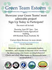
Green Team Esteem Event
 |
|
The Sustainable Jersey Monmouth
County Hub and the Watershed Management Area 12 Watershed Ambassador are delighted to be
hosting the Green Team Esteem event. Environmental organizations from all over
the County will showcase their most admirable projects on Thursday, June 29 from 5 to 7 p.m. at the Monmouth County Agricultural Building, 4000 Kozloski Rd., Freehold. The event is meant to inspire groups and community members to expand their current projects or look for new and out-of-the-box ways to secure points toward Sustainable Jersey certification or re-certification.
If you have questions, email Alexis Bowman, WMA 12 Watershed Ambassador, at Alexis.Bowman@co.monmouth.nj.us
|
|
|
|
|
|
The New
York-New Jersey Harbor & Estuary Program (HEP) is a partnership of
government agencies, civic organizations, and scientists that work towards a
common to-do list for improving the waters, waterfronts, and watersheds of the
NY-NJ Harbor and Estuary, including Raritan and Sandy Hook bays. In May 2016
the MCEC hosted a public workshop for HEP to
assist them in gathering local information to inform their proposed 5-Year
Action Agenda. This agenda is intended to guide how HEP uses funding,
programmatic, and research capacities to carry out shared goals. In the
May 2017 edition of HEPs newsletter, The Tidal Exchange, they
announced the release of their Draft
Action Agenda. The report is available online for review and
comments will be accepted until July 14. The Agenda includes
35 actions for water quality improvement, habitat restoration, public access,
port and maritime management, and public participation/education initiatives.
It is anticipated that the HEP partner agencies, scientists, and civic organizations
will work together to implement these actions. Comments on the draft can
be submitted to HEPAgenda2017@hudsonriver.org. A
final Action Agenda is expected to be released in 2018.
About This Newsletter
The purpose of the newsletter is to inform Monmouth County citizens on the health of their environment and list environmental outreach events in their community. The newsletter is produced by the Monmouth County Division of Planning Environmental & Sustainability Planning Section in coordination with the Monmouth County Environmental Council. The County of Monmouth and the Board of Chosen Freeholders do not necessarily share the viewpoints of any environmental group mentioned in this newsletter.
If you have questions, comments, or wish to have an event listed in the newsletter, please contact: Kyle Clonan Kyle.Clonan@co.monmouth.nj.us
|
|
|
|