Wharton State Forest Visiting Vehicle Use Map - Updated Map
Recognizing the important role the hunting community provides to the management of wildlife populations and broader contributions to conservation, the New Jersey Department of Environmental Protection today announced an amendment to the Wharton State Forest Visiting Vehicle Use Map, adding 8.8 miles of hunting-only access.
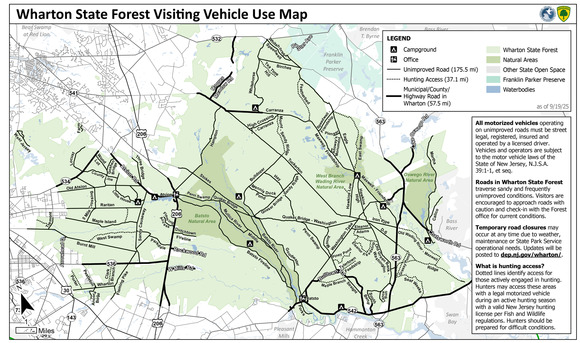
With this update, hunters now have access to 37.1 miles of designated unimproved roads in Wharton State Forest for the sole purpose of hunting. The expanded access is in addition to the 233 miles of roads open to all visitors, providing a total of 270.1 miles of access for hunters.
The Wharton State Forest Visiting Vehicle Use Map was developed with an understanding that the map would be adaptive in nature, changing over time to accommodate environmental conditions (e.g., drought, fire, flooding) and other operational needs and realities within the state forest. The DEP has been in an ongoing dialogue with the hunting community to ensure adequate access to the state forest.
NEW HUNTER ACCESS PASS 🦌
During hunting seasons, hunters may use the 37.1 miles of unimproved roads with a free Hunter Access Pass. To obtain a pass, hunters must visit the Batsto Visitor Center with:
🪪 A valid New Jersey Fish and Wildlife hunting license 🚗 A state-issued driver’s license
The pass must be clearly displayed on your vehicle’s windshield while using unimproved roads designated for hunting access.
The Batsto Visitor Center (31 Batsto Rd., Hammonton) is open daily from 9 a.m. to 4 p.m., excluding state holidays. Hunters should be prepared for rough road conditions. For more information on hunting and regulations, visit https://njfishandwildlife.org/hunting/.
👉 View the updated Wharton State Forest hunting map.
ABOUT THE VISITING VEHICLE USE MAP 🗺️
In Nov. 2024, DEP released the Visiting Vehicle Use Map following a multi-year public engagement process and careful review. The map clearly delineates legal roads for driving in Wharton State Forest, improving visitor safety and experience, supporting State Park Police patrols, enabling routine maintenance, and improving access for emergency response personnel. The map also serves to ensure the protection of wildlife habitat and rare plant species.
The map is available as a georeferenced PDF, allowing drivers to use their mobile device to determine their location on the map in real time, including in areas with limited or no cellular service.
🔗 Learn more: https://njparksandforests.org/wharton
|