|
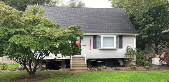
Figure 1 - Foundation damage in Little Falls, New Jersey following Tropical Storm Ida
Follow the links below to register for upcoming trainings being offered by the DEP and FEMA! Each training is one hour and awards one Continuing Education Credit for Certified Floodplain Managers and will provide 0.1 Continuing Education Unit for Uniform Construction Code Officials.
Local Design Flood Elevation Worksheet
Determining a Local Design Flood Elevation involves:
- Integrating three sets of regulations;
- Evaluating FEMA effective and preliminary Flood Insurance Studies, State-studied streams and any flood mapping adopted by local ordinance;
- Determining State and local freeboard requirements;
- Adjusting for datum changes; and
- Choosing the more restrictive of adding freeboard or requiring construction to the 500-year flood for critical buildings.
When Floodplain Administrators make accurate decisions, no one seems to notice. However, when inaccurate decisions are made, they can directly impact insurance affordability for property owners and subject structures to a higher risk of flooding.
Recognizing that accuracy and documentation were two things that would help guide the decision-making process, a worksheet that can be used by Floodplain Administrators to accurately determine the proper flood elevations was created by our department.
Model Code Coordinated Ordinance Rollout
During this training, the DEP will introduce the Model Code Coordinated Ordinance and inform communities on how to adopt and use the ordinance, and what changes communities can expect to see from previous models. All 552 participating communities will have to adopt to remain in good standing with the National Flood Insurance Program. This ordinance incorporates New Jersey Flood Hazard Area Control Act higher floodplain standards and required National Flood Insurance Program regulatory requirements with Statewide Uniform Construction Code flood resistant design requirements. In its post-Sandy recommendations, FEMA suggested that New Jersey move towards code-coordinated ordinances to clarify how each of these regulations and the individuals charged with implementing them at the local level work together to prevent flood damage. These ordinances also address gaps in previous model ordinance language noted in a recent FEMA audit and provide more specific information on how development should be designed, permitted, and constructed to ensure compliance with the National Flood Insurance Program.
Ordinance Administration and Model Permit
New Jersey has recently developed a new Model Code-Coordinated Ordinance which all 552 participating communities will have to adopt to remain in good standing with the NFIP. This training will provide floodplain administrators with the knowledge to navigate New Jersey's Flood Hazard Area Control Act higher floodplain standards, NFIP regulatory requirements, and the Uniform Construction Code's flood resistant design requirements. This training is more in depth than the sessions that rolled out the new ordinance and will focus on administering the ordinance and ensuring that a community's floodplain management program is compliant with the National Flood Insurance Program.
One tool to help with administering the model ordinance is the newly released Floodplain Development Permit. Having and using the Floodplain Development Permit for activities in the floodplain is a FEMA requirement for NFIP participating communities. Recent FEMA compliance assistance visits have indicated that many permits are not actually permits but are notations, tracked on the Uniform Construction Code sleeve. This has raised concerns that key items required in technical bulletins are not being addressed uniformly throughout the state and that key technical information is not being provided as required by applicants during permit application. This model permit is intended to walk floodplain administrators through the permit application, issuance, variance, enforcement stages, ensuring that all required recordkeeping will be maintained.
Back to top.
Municipalities affected by Tropical Storm Ida are reminded that participation in the National Flood Insurance Program requires the evaluation of damaged structures to determine if the cost to restore the structure to the pre-damaged condition exceeds 50% of the structures value. Funds are available to assist municipalities with making these determinations. More information on this process is available in the Emergency Newsletter sent out after the storm. Municipalities are also reminded that all substantial damage determinations must be submitted to the Bureau of Flood Engineering at the following address:
State of New Jersey
Department of Environmental Protection
Climate and Flood Resilience
PO Box 420 Mail Code 44-03A
Trenton, NJ 08625-0420
Attn: Substantial Damage Letter
In addition, communities needing assistance with substantial damage determinations can also reach out to George Ibrahim George.Ibrahim@dep.nj.gov who is coordinating assistance from the newly created Disaster Assistance Response Team. Disaster Assistance Response Team was created to match communities with volunteer Certified Floodplain Managers that are trained in making these determinations.
Back to top.
Pursuant to an audit of New Jersey’s model ordinances by FEMA, all 553 participating communities will have to transition to the Model Code Coordinated Flood Damage Prevention Ordinance. As discussed in the Winter, 2021 Floodplain Communicator, communities may adopt the new ordinance at any time provided that the ordinance is reviewed by the DEP and approved by FEMA before the first reading. These ordinances ensure compliance with the National Flood Insurance Program, the New Jersey Flood Hazard Area Control Act, and the Uniform Construction Code and streamline the adoption process to just two models, riverine or coastal, from six previous models. These ordinances have been recognized as a step forward in flood hazard mitigation by the New Jersey Office of Planning Advocacy and are required as part of participating in the Plan Endorsement Process. In addition, County Hazard Mitigation Plans are now requiring ordinance adoption by participating communities within 6 months of plan adoption.
The new model ordinance is designed to coordinate the efforts of a community’s Floodplain Administrator and Construction Official and to provide more predictability for residents, contractors, and developers than past models that varied by watershed characteristics. This new ordinance presents a statewide approach that encourages shared services for floodplain management and helps new floodplain administrators better understand floodplain management requirements.
Because the new model ordinances represent the State’s minimum floodplain standards, communities are encouraged to customize their ordinances to reflect higher local regulatory standards into their ordinances. The DEP is tracking higher standards language adopted by participating communities and can provide examples to interested communities. It is recommended that that either Kenya Lovill or Rebecca Jones be contacted early in the adoption process to discuss ways to incorporate higher standards or make any requested modifications to the model ordinance so that it remains compliant with the State laws referenced in the model.
County-wide adoptions are ongoing in Atlantic, Cape May, Ocean, and Monmouth Counties and were initiated with a letter written on behalf of FEMA that required adoption of the new code coordinated ordinance within 6 months of the date of the letter. County-wide adoptions will be phased in over the next few years and will be coordinated with FEMA’s map adoption process. Letters will be going out to Hudson and Middlesex counties this month requiring they update their ordinance to the new Model Code Coordinated Ordinance.
Voluntary adoptions have been completed in 8 municipalities. If your municipality is interested in updating your ordinance to the Model Code Coordinated Ordinance, please contact either Kenya Lovill or Rebecca Jones to ensure the model being adopted is appropriate for your floodplain and the draft ordinance is approved by the DEP and FEMA prior to introduction.
Back to top.
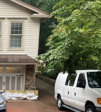
Figure 2 - An image of a house outside of FEMAs Special Flood Hazard Area and on the side of a mountain. The homeowner has devised a system of sandbags and plywood to protect his garage and finished basement from stormwater flow that exceeds the designed culvert size. Properties such as this should consider carrying flood insurance.
An analysis of recent National Flood Insurance Program insurance claims data indicates that 37% of post-Henri and 31% of post-Ida claims occurred outside of a mapped Special Flood Hazard Area, represented as the 1% annual chance (100-year) storm. These numbers reflect only NFIP policies and do not include claims made by individuals affected by flooding who filed with FEMA for Individual Assistance and/or individuals or businesses affected by flooding that do not have flood insurance or policy claims data from private flood insurance providers. This data underscores the need for outreach to residents and commercial property owners letting them know that they can purchase an NFIP Insurance Policy even if they are not required to as a condition of their mortgage contract or are outside of the special flood hazard area. Figure 2 is a photo of a house which is not in a FEMA-mapped floodplain and on the side of a mountain. The homeowner has devised a system of sandbags and plywood to protect his garage and finished basement from stormwater flow that exceeds the designed culvert size and was of sufficient velocity to move 12-inch diameter non-native rock fill material placed further up the mountain into his yard. The homeowner is considering buying a flood insurance policy as he pursues a solution with his municipality to the uphill stormwater flooding.
The following insurance materials are helpful to both businesses and individuals and are also available in Spanish.
Back to top.
In the case where an emergency exists that poses a threat to health and human safety and/or a danger to the environment, there are provisions which allow for work to be conducted to take care of the emergency situation in a way that also meets the various rules and regulations administered by this Division. To assist the public and regulated community in understanding what these provisions are, the Division of Land Resource Protection has provided regulatory guidance on various emergency related topic. More information is available on the Division of Land Resource Protection website here.
Back to top.
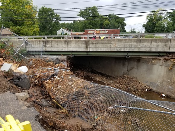
Figure 3 - Accumulated debris at a bridge crossing in Little Falls, New Jersey following Tropical Storm Ida.
Stream cleaning entails de-silting or de-snagging a channel, or removing accumulated garbage or debris, as seen in Figure 3 above. It does not entail making a channel deeper or wider than it previously was, as this could result in worsened flooding on properties located downstream of the area to be cleaned.
Cleaning a stream is a regulated activity under the Flood Hazard Area Control Act Rules. If the project is also regulated pursuant to the Coastal Zone Management Rules at N.J.A.C. 7:7, then no separate flood hazard area approval is required. In these instances, the applicant need only submit a report and plans demonstrating compliance with the Flood Hazard Area Control Act Rules as part of the coastal permit application.
Stream cleaning may be authorized under Permit-By-Rule 5 at N.J.A.C. 7:13-7.5. This permit-by-rule authorizes the removal of accumulated sediment and debris by hand, using handheld equipment. Heavy machinery may not be used. Additional requirements apply to protect the riparian zone, trout, and to preserve the natural bed and banks of the channel. Additional Federal, State, and local requirements may apply to the placement of material removed from the water.
In cases where machinery is required to remove one or more major obstructions from a regulated water that cannot be removed by hand, Permit-By-Rule 6 may apply. This permit allows the use of machinery provided it is situated outside of the water, fill material or sediment is not removed from the water, disturbance to riparian zone vegetation is limited to that which is necessary for access, and material removed from the water is disposed of legally.
General Permit-By-Certification 1 at N.J.A.C. 7:13-8.1 authorizes the removal of accumulated sediment and debris from a regulated water for agricultural purpose. See the “Agricultural Activities” tab under the “Common Project Types” of the Division of Land Resource Protection website.
Stream cleaning may be authorized under a Flood Hazard Area General Permit 1. In order to qualify for this general permit, the applicant must be a government entity. Disturbance to riparian zone vegetation must be minimized pursuant to the specific requirements of this permit. There are particular application requirements for this general permit as described at N.J.A.C. 7:13-9.1(d). An application checklist for this general permit is available here in the “Forms and Checklists” section of the Division of Land Resource Protection's website.
Should the applicant not qualify for any of the above, then stream cleaning may be authorized under a Flood Hazard Area Individual Permit in accordance with N.J.A.C. 7:13-10, 11, and 12.
Before designing and bidding any project such as stream bank restoration that may require a general or individual permit, it is recommended that applicants schedule a pre-application planning meeting to ensure that planned activities are in compliance with State law and do not exacerbate either upstream or downstream flooding. Please consult the Pre-Application Meeting Checklist in preparation for any meeting.
Back to top.
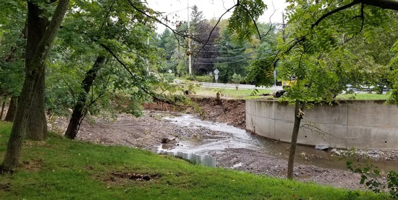
Figure 4 - This image depicts the meandering of the Peckman River and undermining behind a bridge abutment
The National Resource Conservation Service Emergency Watershed Protection Program allows communities to quickly address serious and long-lasting damages to infrastructure and to the land. The program’s timelines for assistance ensures National Resource Conservation Service must act quickly to help local communities cope with adverse impacts resulting from natural disasters. All projects must demonstrate that they reduce threats to life and property; be economically, environmentally and socially sound and must be designed to acceptable engineering standards. The Emergency Watershed Protection Program also allows the National Resource Conservation Service to establish non-traditional partnerships with sponsors to complete projects.
The following two programs are available through the National Resource Conservation Service:
1. Emergency Watershed Protection Program - Recovery
National Resource Conservation Service provides financial and technical assistance for the following activities under the Emergency Watershed Protection Program – Recovery:
- debris removal from stream channels, road culverts and bridges;
- reshape and protect eroded streambanks;
- correct damaged drainage facilities;
- establish vegetative cover on critically eroding lands
- repair levees and structures; and
- repair conservation practices.
Eligibility:
Public and private landowners can apply for assistance for the Emergency Watershed Protection Program – Recovery projects through a local sponsor, or a legal subdivision of state or tribal government. Eligible sponsors include cities, counties, towns, conservation districts, flood and water control districts, or any federally-recognized Native American tribe or tribal organization.
Sponsors are responsible for the following:
- providing land rights for the repairs;
- securing the necessary permits;
- providing the sponsor funding for repairs;
- ensuring the repairs are installed; and
- completing the repairs using federal or local contracts.
Emergency Watershed Protection Program Funding:
- Congress approves all Emergency Watershed Protection Program funding.
- The National Resource Conservation Service can pay up to 75 percent of the cost for eligible emergency projects. Local sponsors must acquire the remaining 25 percent in cash or in-kind services.
2. Emergency Watershed Protection Program Assistance Through Floodplain Easements
The National Resource Conservation Service also provides financial and technical assistance under the Emergency Watershed Protection Program – Floodplain Easements:
- The National Resource Conservation Service may purchase Emergency Watershed Protection Program floodplain easements instead of trying to recover damaged floodplain land. Permanent Emergency Watershed Protection Program floodplain easements can be used if they prove more cost effective than recovery. Landowners interested in enrolling their land in a permanent Emergency Watershed Protection Program floodplain easement should contact their local United States Department of Agriculture Service Center.
For more information on these National Resource Conservation Service Programs, please contact Hilary Trotman, P.E. at hilary.trotman@usda.gov.
Back to top.
Intense rainfall events such as Tropical Storm Ida, which dropped significant amounts of rainfall over a short period of time, are becoming more common. New Jersey’s Scientific Report on Climate Change predicts that intensity and frequency of precipitation events will increase with the annual precipitation expected to increase by 4% to 11% by 2050. Additionally, the DEP has released two studies by the Northeast Regional Climate Center, a National Oceanic and Atmospheric Administration partner, confirming increases in precipitation across New Jersey over the last 20 years, and projecting further increases in precipitation intensity through the end of this century due to climate change. These two studies, titled , Changes in Hourly and Daily Extreme Rainfall Amounts in NJ since the Publication of NOAA Atlas 14 Volume and Projected Changes in Extreme Rainfall in New Jersey based on an Ensemble of Downscaled Climate Model Projections, show:
- Precipitation is already 2.5% to 10% higher. The precipitation expectations that presently guide state policy, planning and development criteria, and which rely upon data obtained through 1999, do not accurately reflect current precipitation intensity conditions. Extreme precipitation amounts are 2.5% higher now than the 1999 data suggests, and some parts of the state have seen a 10% increase above the outdated data.
- Precipitation is likely to increase by more than 20% from the 1999 baseline by 2100, and projected changes will be greater in the northern part of the state than in the southern and coastal areas, with projections for some northwestern counties seeing the greatest increase, some by as much as 50%.
This increase in precipitation intensity is eroding landforms that may have been stable under less intensive rainfall scenarios but are now subject to higher volumes of stormwater flow at higher velocities.
Areas of concern in New Jersey are large deposits of unconsolidated sediments which are subject to high velocity/high volume stormwater flows. These areas include coastal plain sediments in central and southern New Jersey and glacial sediments in northern New Jersey. Knowing the location and thickness of these deposits and their susceptibility to erosion or instability are key to effective stormwater, floodplain, and emergency management in these areas. The NJ Geological and Water Survey maps surficial and bedrock geology throughout New Jersey and offshore along the Atlantic Ocean shoreline. Maps are available for electronic download or for purchase at www.njgeology.org or can be obtained by accessing the DEP’s Surficial Geology Layer on NJGeoweb (under the "Geology" tab). Cross sections are also available in certain publications that show the thickness of glacial deposits and depth to bedrock in northern New Jersey.
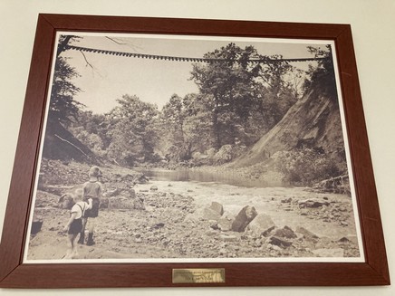 |
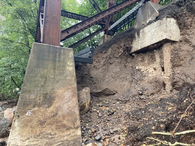
Figure 5 - This image is an historic image that hangs in the Little Falls Town Hall. It shows the washout of the railroad arch over the Peckman River after a flood in 1945. This image was taken by Joe and Jan Sandri.
Figure 6 - This image was taken after Tropical Storm Ida under the railroad bridge over the Peckman River in Cedar Grove, New Jersey.
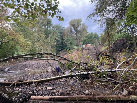
Figure 7 - Red shipping container on the edge of the stream bank wasting, upstream of the railroad bridge in Cedar Grove.
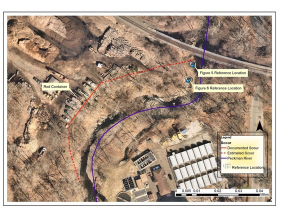
Figure 8 - Aerial image taken in 2021 Prior to Tropical Storm Ida, of the Peckman River that shows reference points for Figures 6 and 7 and the estimated and documented bank wasting that occured during the storm.
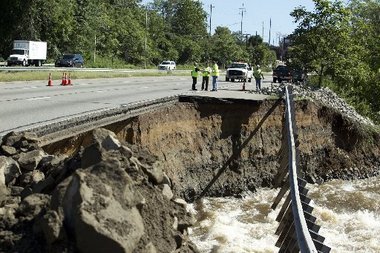
Figure 9 - This image depicts the Route 287 collapse near Boonton, Morris County in August, 2011 (Hurricane Irene) which resulted from erosion of glacial outwash soils along the Rockaway River. Photo Credit: Steve Hockstein for the Star-Ledger
Figure 5 above shows the Peckman River bridge crossing of the Montclair-Boonton Line in Cedar Grove Township, Essex County in 1945 after the erosion of a glacial alluvial deposit composed mainly of sands and silts. The rail line was suspended but intact after the previous train bridge was washed out in this storm event. Because the Peckman drainage basin starts uphill in West Orange Township, Essex County and travels 5.9 miles to the location of this crossing with a vertical drop of 323 feet. At its steepest point, the river drops 100 feet in 1.15 miles from Pompton Ave to the NJ Transit Train bridge. Erosion and flash floods were experienced in this area during the unnamed August, 2018 storm as well as Hurricane Ida in 2021. Figure 6 shows the recent erosion on the upstream side of 1945 replacement trestle bridge foundations. Figure 7 shows the recent erosion of approximately 30 feet of river bank at a property that is not in a mapped floodplain. This photo is taken from stream level near the bridge crossing. Figure 8 is an aerial view of the Peckman area, from 2021 prior to Tropical Storm Ida, that shows reference points for Figures 6 and 7 and documents the bank and vegetation loss along the Peckman River in this area. Figure 9 shows the Rt 287 collapse near Boonton, Morris County in August, 2011 (Hurricane Irene) which resulted from erosion of glacial outwash soils along the Rockaway River. These photos illustrate the danger present in flood-related erosion-prone areas.
Also of concern, though not regulated as a flood-related hazard are the coastal bluffs in Atlantic Highlands and Highlands. These areas have a documented history of landslides which these towns actively monitor and manage. Figure 10 (below) shows a landslide that occurred in August, 2011 due to precipitation from Hurricane Irene. More information is available on the Atlantic Highlands website and the USGS also provides information on the landslide monitoring system implemented in this area. Stormwater management and erosion control are necessary in these areas but NFIP regulations may preclude NFIP insurance coverage related to a landslide event. More information about the differences is available below in the Landslide and Mudflow insurance Coverage and the NFIP section.
Figure 10 - Landslide scarp in Atlantic Highlands caused by extreme precipitation after Hurricane Irene.
Communities should actively manage areas where erosion and landslides are possible, should implement land use and floodplain management ordinances where necessary and should incorporate specific emergency management measures into their hazard mitigation planning. Communities should also consider stormwater and riparian buffer best practices and potential grant funding sources to minimize erosion impacts in their communities.
In watersheds with multiple municipalities and differing levels of risk based upon the underlying geology and sediment compositions, it is recommended that a regional planning approach be pursued to regulate new construction and substantial improvements and to mitigate hazards that occur in the watershed beyond municipal boundaries. Municipalities are further encouraged to enact land use and flood damage prevention ordinances that reduce or do not exacerbate downstream impacts.
Back to top.
According to the National Flood Insurance Program regulations, 44 CFR 60.5, areas subject to flood-related erosion-prone areas may be mapped by FEMA and designated with an “E” (Area of special flood-related erosion hazards) on flood maps, Without reviewing all FEMA map panels, to the knowledge of the Bureau of Flood Engineering staff, there are no areas with an “E” designation in New Jersey. In situations where FEMA has not formally designated an area as having special flood-related erosion hazards, the community is directed to “obtain, review, and reasonably utilize data available from other Federal, State or other sources”. Communities are further directed to follow 44 CFR 60.5(a) by issuing permits in these areas even if they are not in the Special Flood Hazard Area, evaluate applications to determine if alterations and improvements are “reasonably safe from flood-related erosion and will not cause flood-related erosion hazards or otherwise aggravate the existing flood-related erosion hazard”, and “if a proposed improvement is found to be in the path of flood-related erosion or to increase the erosion hazard, require the improvement to be relocated or adequate protective measures to be taken which will not aggravate the existing erosion hazard”.
The full text of 44 CFR 60.5 is as follows:
§ 60.5 Flood plain management criteria for flood-related erosion-prone areas.
The Federal Insurance Administrator will provide the data upon which flood plain management regulations for flood-related erosion-prone areas shall be based. If the Federal Insurance Administrator has not provided sufficient data to furnish a basis for these regulations in a particular community, the community shall obtain, review, and reasonably utilize data available from other Federal, State or other sources, pending receipt of data from the Federal Insurance Administrator. However, when special flood-related erosion hazard area designations have been furnished by the Federal Insurance Administrator they shall apply. The symbols defining such special flood-related erosion hazard designations are set forth in § 64.3 of this subchapter. In all cases the minimum requirements governing the adequacy of the flood plain management regulations for flood-related erosion-prone areas adopted by a particular community depend on the amount of technical data provided to the community by the Federal Insurance Administrator. Minimum standards for communities are as follows:
(a) When the Federal Insurance Administrator has not yet identified any area within the community as having special flood-related erosion hazards, but the community has indicated the presence of such hazards by submitting an application to participate in the Program, the community shall
(1) Require the issuance of a permit for all proposed construction, or other development in the area of flood-related erosion hazard, as it is known to the community;
(2) Require review of each permit application to determine whether the proposed site alterations and improvements will be reasonably safe from flood-related erosion and will not cause flood-related erosion hazards or otherwise aggravate the existing flood-related erosion hazard; and
(3) If a proposed improvement is found to be in the path of flood-related erosion or to increase the erosion hazard, require the improvement to be relocated or adequate protective measures to be taken which will not aggravate the existing erosion hazard.
(b) When the Federal Insurance Administrator has delineated Zone E on the community's FIRM, the community shall
(1) Meet the requirements of paragraph (a) of this section; and
(2) Require a setback for all new development from the ocean, lake, bay, riverfront or other body of water, to create a safety buffer consisting of a natural vegetative or contour strip. This buffer will be designated by the Federal Insurance Administrator according to the flood-related erosion hazard and erosion rate, in conjunction with the anticipated “useful life” of structures, and depending upon the geologic, hydrologic, topographic and climatic characteristics of the community's land. The buffer may be used for suitable open space purposes, such as for agricultural, forestry, outdoor recreation and wildlife habitat areas, and for other activities using temporary and portable structures only.
Back to top.
In High-Risk Flood Hazard Areas, ASCE 24-14, Flood Resistant Design and Construction, allows the prohibition of new construction and substantial improvements to structures in areas subject to mudslides, flash floods, erosion-prone areas, high velocity flow areas and ice jam and debris areas* unless protective works are designed to provide protection to the design flood event. The process for establishing these areas is documented in Chapter 3, High Risk Flood Hazard Areas, and requires that the municipality document specific characteristics of these areas in an engineering report and designate the affected area under ASCE 24-14-1.3.2. Any flood protective work such as dams, levees, floodwalls, diversions, channels, flood control structures, and other protective works in these areas must be shown on a flood hazard map as providing protection during design flood conditions under ASCE 24-14-1.4.2 and have an established maintenance and operations plan.
Engineering report analyses should document the analyses and define the methodology and data used to conclude that the area is a High Risk Flood Hazard Area and any protective works is designed, maintained, and operated to protect against the design flood. This required information is as follows:
1. Flash Flood Areas
a. Documentation that flash flooding is equal to or less than the design flood conditions.
b. Historical information on past events and an analysis of historic rainfall and runoff data for the watershed.
2. Mudslide Areas
a. Areas subject to inundation by mudslides shall be investigated to obtain historical information on past flood events.
b. An analysis of the source area for potential overland or channel erosion, bank failure, hillslope failure, and rainfall/runoff potential.
3. Erosion-Prone Areas
a. Documentation of such phenomena as caving banks, meandering streams, or eroding shorelines where such erosion is predicted to affect the structure unless a protective work is in place that meets ASCE 24-14-1.4.2.
b. Analysis of available studies, historical data, watershed trends, average annual erosion rates, wave effects, flood velocities, and duration of flow, geotechnical data, and existing protective works.
4. High Velocity Flow Areas
a. Areas shall be identified from a community’s flood hazard map, flood hazard study, or from hydraulic analyses.
5. Ice Jam and Debris Areas
a. Documentation that areas are subject to transportation of damage-causing ice or debris during floods up to and including the design flood.
b. The potential for ice or debris capable of inducing or causing loads exceeding design loads shall be identified from a community’s flood hazard map, or flood hazard study, or from hydraulic or other analyses.
*Note: Alluvial fans are also possible high risk flood hazard areas but are more prevalent in arid climates so they were not included in this newsletter. Areas subject to wave action are not included because all new and substantial improvements in New Jersey’s coastal areas must meet Chapter 4 of ASCE 24-14 under the Uniform Construction Code.
Any community opting to develop engineering reports for high-risk flood hazard areas must also identify and incorporate a description of these areas and ordinance language prohibiting new and substantial improvements to structures in these areas in their flood damage prevention and other zoning ordinances. Because High Risk Flood Hazard Areas represent a limitation on new building, it is recommended that any engineering report and ordinance adoption process be open and transparent to the maximum extent possible so that the community and any affected property owners are given appropriate notice of any changes.
Back to top.
The New Jersey Flood Hazard Area Control Act (NJAC 7:13) establishes jurisdiction over riparian zones which may provide a minimum level of protection in high-risk flood areas. A riparian zone is the land and vegetation within and adjacent to a regulated water. Riparian zones exist along both sides of every regulated water and include the regulated water itself. The extent of the riparian zone is determined by the attributes of the water. The portion of the riparian zone located outside of a regulated water is measured landward from the top of bank.
The width of the riparian zone under the Flood Hazard Area Control Act is as follows:
1. The width of the riparian zone along any regulated water designated as a Category One water, and all upstream tributaries situated within the same HUC-14 watershed, is 300 feet;
2. Except for the regulated waters listed at (c)1 above, the width of the riparian zone along the following regulated waters is 150 feet:
a. Any trout production waters and all upstream waters (including tributaries);
b. Any trout maintenance water and all upstream waters (including tributaries) located within one mile of a trout maintenance water (measured along the length of the regulated water); and
c. Any segment of a water flowing through an area that contains a threatened or endangered species, and/or present or documented habitat for those species, which is critically dependent on the water for survival, and all upstream waters (including tributaries) located within one mile of such habitat (measured along the length of the regulated water).
3. For all other regulated waters not identified above, the width of the riparian zone is 50 feet.
For more details on riparian zones, see N.J.A.C. 7:13 Flood Hazard Area Control Act Rules or the Technical Manual: Flood Hazard Area Control Act Rules N.J.A.C. 7:13.
The clearing, cutting, and/or removal of vegetation in a riparian zone is a regulated activity under the Flood Hazard Area Control Act Rules and requires authorization under the Flood Hazard Area Control Act rules. Each Permit-by-Rule, General Permit by Certification, General Permit, and Individual Permit sets allowable limits for vegetation removal in the riparian zone. Floodplain Administrators should be familiar with the requirements of these general permits, encourage property owners to abide by these requirements, and notify the DEP Coastal and Land Use Enforcement of any violations.
Riparian zone vegetation and root systems anchor stream banks and are an important part of stream bank stability. Riparian zone vegetation is the original “nature-based infrastructure” and is an important soil conservation tool for preventing stream meandering and undermining of banks. While the planting of vegetation may not be desirable for some property owners because it impedes the view of the stream and can catch debris, the value of placing vegetation capable of withstanding high velocities during flash flooding can be offset by the benefits of stabilizing vulnerable areas and preventing property loss.
Back to top.
The following is listed in the Summary of Coverages documents listed in earlier in the newsletter.
National Flood Insurance Program flood insurance policies cover direct physical losses, damage, or loss caused by a flood. In simple terms, a flood is an excess of water on land that normally is dry. The official definition used by the NFIP is “A general and temporary condition of partial or complete inundation of two or more acres of normally dry land area or of two or more properties (at least one of which is your property) from:
- Overflow of inland or tidal waters;
- Unusual and rapid accumulation or runoff of surface waters from any source;
- Mudflow*; or
- Collapse or subsidence of land along the shore of a lake or similar body of water as a result of erosion or undermining caused by waves or currents of water exceeding anticipated cyclical levels that result in a flood as defined above.”
*Mudflow is defined as “A river of liquid and flowing mud on the surfaces of normally dry land areas, as when earth is carried by a current of water. Other earth movements such as landslide, slope failure, or a saturated soil mass moving by liquidity down a slope, are not mudflows.
This definition is very important because it distinguishes between a landslide, slope failure, and a saturated soil mass moving by liquidity down a slope, which are not covered by an NFIP Flood Insurance Policy and a mudflow, which is covered by an NFIP Flood Insurance Policy.
The United States Geological Survey has a much more expansive definition of a landslide and defines it as “the movement of a mass of rock, debris, or earth down a slope. Landslides are a type of "mass wasting," which denotes any down-slope movement of soil and rock under the direct influence of gravity. The term "landslide" encompasses five modes of slope movement: falls, topples, slides, spreads, and flows. These are further subdivided by the type of geologic material (bedrock, debris, or earth). Debris flows (commonly referred to as mudflows or mudslides) and rock falls are examples of common landslide types.” This means that while the USGS include debris flows including mudflows in the definition of a landslide, the NFIP does not define a mudflow to include other types of landslides.
Because the NFIP only considers flood-related damage, the USGS explanation of landslide causes provides insight to why the NFIP limits coverage solely to mudflows. This explanation is as follows:
Almost every landslide has multiple causes. Slope movement occurs when forces acting down-slope (mainly due to gravity) exceed the strength of the earth materials that compose the slope. Causes include factors that increase the effects of down-slope forces and factors that contribute to low or reduced strength. Landslides can be initiated in slopes already on the verge of movement by rainfall, snowmelt, changes in water level, stream erosion, changes in ground water, earthquakes, volcanic activity, disturbance by human activities, or any combination of these factors. Earthquake shaking and other factors can also induce landslides underwater. These landslides are called submarine landslides. Submarine landslides sometimes cause tsunamis that damage coastal areas.
While this newsletter cannot attempt to definitely answer or predict what an insurance claims adjuster would decide regarding an affected structure after an event, property owners at risk of either a mudflow or a landslide should consider purchasing both flood insurance and landslide insurance policies to ensure that they are covered for both types of risk.
Additional information is available at the following websites:
Back to top.
Any repair, restoration, and replacement of damaged facilities after a storm event requires a recipient of FEMA public assistance to maintain insurance of the repaired facility. Facilities can include any publicly or privately owned building, works, system, or equipment built or manufactured, or an improved and maintained natural feature. As a condition of funding, the recipient is also required to perform operation and maintenance of the facility to keep the project eligible for funding should it experience damage in the future.
As New Jersey experiences even more events like Tropical Storm Ida, it is even more important to have effective asset management practices. As part of the Climate Change initiative, DEP developed a Stormwater Infrastructure Toolkit that provides a set of best practices for stormwater infrastructure operations and maintenance and asset management. Keeping equipment operating and performing as designed helps prevent loss of both lives and property.
For more information in FEMA’s Public Assistance Policy on Insurance, FP 206-086-1.
Back to top.
|