 Figure 1: Photo depicts the barrier island in Mantoloking being breached and “the only house still standing” due to its pile foundation and elevation. During Superstorm Sandy 2012, the floodwater elevation in this area reached seven feet.
Source: FEMA P-942 Mitigation Assessment Team Report Hurricane Sandy in New Jersey and New York
Welcome!
Welcome to the spring edition of the Floodplain Communicator, published by New Jersey’s National Flood Insurance Program Coordinator’s Office! If you have not already, please update your subscriber preferences page and answer the questions in our survey. This will help us provide you with information tailored to your interests or location. Follow this link to update your subscriber preferences page.
First Model Code Coordinated Ordinance Adopted!
Our department would like to congratulate Riverdale Borough for being the first National Flood Insurance Program participating municipality to adopt the recently released Model Code Coordinated Ordinance! As mentioned in previous newsletters, all 553 NFIP participating communities will need to adopt these new ordinances to ensure compliance with the program. If your community is interested in updating their ordinance please email Kenya Lovill and visit our website for more information.
In this edition:
The DEP is offering the following trainings on the new Model Code Coordinated Ordinance Administration, Model Permit Roll Out, and on the new Local Design Flood Elevation Worksheet. Please follow the links below to register. All sessions offered through the DEP will provide one Continuing Education Credit for Certified Floodplain Managers and will provide 0.1 Continuing Education Unit for Uniform Construction Code Officials. The NJAFM Sessions will provide one Continuing Education Credit for Certified Floodplain Managers, one Professional Development Hour credit and 0.1 Continuing Education Unit for Uniform Construction Code Officials.
Ordinance Administration Training
New Jersey has recently developed a new Model Code-Coordinated Ordinance which all 552 participating communities will have to adopt to remain in good standing with the NFIP. This training will provide floodplain administrators with the knowledge to navigate New Jersey's Flood Hazard Area Control Act higher floodplain standards, NFIP regulatory requirements, and the Uniform Construction Code's flood resistant design requirements. This training is more in depth than the sessions that rolled out the new ordinance and will focus on administering the ordinance and ensuring that a community's floodplain management program is compliant with the National Flood Insurance Program. The DEP will offer trainings on this topic at the following dates and times:
Model Floodplain Development Permit Roll Out
FEMA requires that NFIP participating communities have a floodplain development permit. Recent FEMA compliance assistance visits have indicated that many permits are not actually permits but are notations, tracked on the Uniform Construction Code sleeve. This has raised concerns that key items required in technical bulletins are not being addressed uniformly throughout the state and that key technical information is not being provided as required by applicants during permit application. This model permit is intended to walk floodplain administrators through the permit application, issuance, variance, enforcement stages, ensuring that all required recordkeeping will be maintained. This model permit can be found on the Bureau of Flood Engineering website. The DEP will offer trainings on this topic at the following dates and times:
Local Design Flood Elevation Worksheet Training
Determining a Local Design Flood Elevation involves:
- Integrating three sets of regulations;
- Evaluating FEMA effective and preliminary Flood Insurance Studies, State-studied streams and any flood mapping adopted by local ordinance;
- Determining State and local freeboard requirements;
- Adjusting for datum changes; and
- Choosing the more restrictive of adding freeboard or requiring construction to the 500-year flood for critical buildings.
When Floodplain Administrators make accurate decisions, no one seems to notice. However, when inaccurate decisions are made, they can directly impact insurance affordability for property owners and subject structures to a higher risk of flooding.
Recognizing that accuracy and documentation were two things that would help guide the decision-making process, a worksheet that can be used by Floodplain Administrators to accurately determine the proper flood elevations was created by our department, and can be found on the Bureau of Flood Engineering website. The DEP will offer trainings on these worksheets at the following dates and times:
*In order to attend the NJAFM training sessions you must be a member. These sessions will offer one Continuing Education Credit for Certified Floodplain Managers, one Professional Development Hour credit and 0.1 Continuing Education Unit for Uniform Construction Code Officials. Visit the NJAFM Webinars webpage to register for these sessions. To become a member follow this link.
Back to top.
The New Jersey Society of Professional Land Surveyors (NJSPLS) is offering a course for New Jersey Licensed Land Surveyors to become Certified Floodplain Surveyors. This training program is offered through the National Society of Professional Surveyors. New Jersey will join two other states in offering this certification opportunity which expands a surveyor's knowledge of this specialized aspect of the profession. To date, North Carolina and Tennessee have certified 200 and 56 surveyors, respectively. The NJDEP, FEMA, and the New Jersey State Board of Professional Engineers and Land Surveyors support this certification because it improves the accuracy of the data that property owners submit to the NFIP and private insurers to use in determining insurance premiums.
This 20 hour course will be offered October 20 - 22 at the Clarion Hotel in Toms River. An exam will be offered at the end of the course to gain certification. The 20 credits are approved by the New Jersey State Board of Professional Engineers and Land Surveyors for CEU credits. NJSPLS will maintain a list of members who have CFS certification on their website.
Topics covered are:
- National Flood Insurance Program (NFIP) overview, objectives and terminology
- NFIP regulations for floodplain management and mitigation (federal, state and local)
- Finding, reading and using Flood Insurance Rate Maps (FIRMS) and supporting data
- Elevation Certificates - their uses and correct completion
- Letters of Map Change (LOMC) definitions, distinctions and purposes
- LOMC applications
More information on upcoming events and registration can be found by following this link.
Back to top.
Jones, R. Stanford, S., Rancan, H., Lovill, K., Gould, A.C., April, 2021
The Department of Environmental Protection’s Bureau of Flood Engineering consulted with the NJ Geological and Water Survey to better understand the geological units underlying New Jersey’s Coastal High Hazard (V Zones) and Coastal A Zones. These zones are mapped on the Federal Emergency Management Agency’s flood insurance rate maps. Construction in these zones must withstand high wave velocities and wave heights greater than 1.5 feet. This article was written to provide architects, engineers, and property owners with information about the relative erodibility of surficial soils and shallow bedrock units in and adjacent to current Coastal High Hazard (V Zones) and Coastal A zones so that property owners can evaluate high risk and use more robust building standards in areas vulnerable to sea level rise.
Siting and construction of structures in V and Coastal A Zones is regulated under the Uniform Construction Code, the New Jersey Flood Hazard Area Control Act, and a National Flood Insurance Program participating community’s Flood Damage Prevention Ordinance implementing the NFIP’s construction regulations in 44 CFR Part 60. Structures must have the lowest horizontal structural member situated above the Local Design Flood Elevation. The space below the Local Design Flood Elevation must be free of obstruction or constructed with non-supporting breakaway walls and be used solely for parking, storage, and access to the structure. Specific requirements for habitable buildings, non-residential structures, floodproofing design and enclosure design are also specified in these regulations. All foundations must meet Uniform Construction Code regulations which defer to the American Society of Civil Engineers Flood Resistant Design and Construction (ASCE 24-14), a nationwide standard. New Jersey’s Uniform Construction Code Statute (N.J.S.A. 52:27D) requires the state to “have a uniform, modern construction code which will insure health, safety, and sanitary construction but also less expensive construction for the citizens of the State”. In accordance with this requirement, New Jersey has adopted portions of the International Code Council codes. The International Code Council codes for Coastal High Hazard and Coastal A Zones reference the flood resistant design standards found in Chapter 4 of ASCE 24-14. In these areas, all foundations must be “deep foundations” (Section 4.5.1) extending at least 10 feet below the Mean Water Level. However, ASCE 24-14 allows certain exceptions for shallow foundations. These exceptions are in areas with non-erodible soils or bedrock (Section 4.5.1.1) and where shallow foundation elements are designed to be supported directly upon undisturbed soil with the reinforced foundation element located below the eroded ground surface to prevent sliding, uplift, or overturning Section 4.5.1.2).
During flooding events, foundations are subject to a combination of loads from wind, wave action, uplift, debris impact, etc. ASCE 24-14 is a minimum standard, but it also provides commentary that encourages design professionals to consider site specific conditions and build appropriately for those conditions. Because foundation failure often results in catastrophic losses such as those discussed below in “Outcomes from Inadequate Foundation Design in Areas with Erodible Soils”, improving awareness of New Jersey’s surficial soil characteristics and underlying bedrock may help design professionals to advocate for stronger foundations that can protect structures from the effects of wave action and sea level rise over a building’s typical 50-year lifecycle. In areas with erodible soils adjacent to current V and Coastal A Zones, building stronger foundations may decrease the cost of ownership when future flood damage and recovery costs are considered.
Back to top.
ASCE 24-14 defines erodible soil as: “soil subject to wearing away, shifting, and movement due to the effects of wind, water, or other geological processes during a flood or over a period of years.” The vast majority of soils in the New Jersey’s Coastal High Hazard and Coastal A Zones are erodible because these soils consist of sediments deposited through geological processes as sea level rose since the last Ice Age 13,000 years ago and also during older periods of high sea level and fill materials placed there due to anthropogenic (human) activity.
From a geotechnical standpoint, factors such as soil characteristics, climate, compaction, salinity, wind, and water velocity affect a soil’s erodibility potential. Determining which soils are erodible cannot be based solely upon soil properties such as those in Unified Soil Classification System in Chapter 3 of ASCE 7-16, Minimum Design Loads for Buildings and Other Structures. A link to this classification chart is provided as a quick reference. Some efforts have been made by researchers at Texas A&M University Transportation Institute in a paper entitled “Relationship between Erodibility and Properties of Soils”, J.L. Briaud, et. al, 2019, to better predict erodibility. This paper correlates Unified Soil Classification soil properties with water velocity and shear stress to determine a soil’s potential erodibility using laboratory testing. A summary of this paper can be found by following this link. Texas A&M University’s laboratory testing produced the graphs in Figure 2, below, which provide a relative snapshot of the erosion potential over a broad spectrum of soil types. It is a helpful resource but should not be used for design purposes. To better understand soil properties at a proposed construction site, a geotechnical investigation for a foundation design performed by a geotechnical professional is highly encouraged.
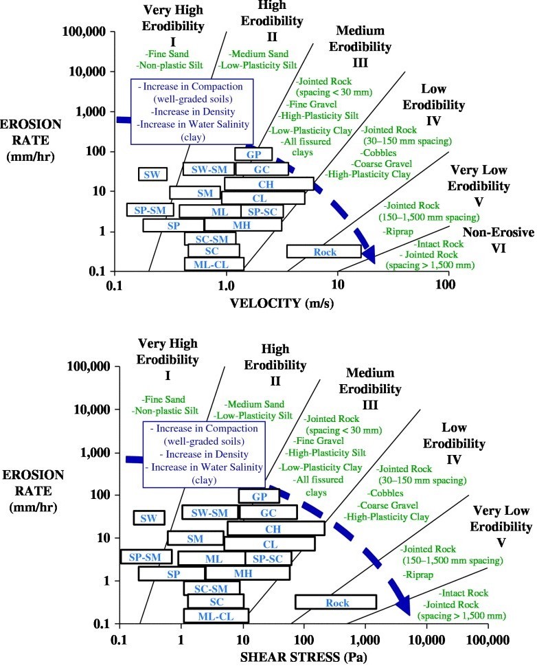 |
Figure 2. Source: “Relationship between Erodibility and Properties of Soils” < J.L. Briaud, et. al, 2019
Back to top.
The NJ Geological and Water Survey maps surficial and bedrock geology throughout New Jersey and offshore along the Atlantic Ocean shoreline. Maps are available for electronic download or for purchase at www.njgeology.org or can be obtained by accessing the DEP’s Surficial Geology Layer on NJGeoweb (under the "Geology" tab). In the coastal Special Flood Hazard area, surficial units are described based upon the era of deposition (the Quaternary period noted as “Q”) and the environment when it was deposited. The most common units in the coastal Special Flood Hazard Area are beach sand and estuarine deposits:
-
Qbs – Beach and Nearshore Marine Sand - Sand and pebble gravel, very pale brown to light gray. Deposited during sea level rise.
-
Qmm – Salt Marsh and Estuarine Deposits - Silt, sand, peat, clay, minor pebble gravel; brown, dark-brown, gray, black. Contain abundant organic matter. Deposited in salt marshes, estuaries, and tidal channels during sea-level rise.
The surficial geologic units consist of various proportions of the soil types in the Uniform Soil Classification System referenced in ASCE publications. Most of the surficial geologic units in the coastal zone are sands and silts that are of very high to high erodibility (categories I and II) according to the classification in Figure 2 above. A small fraction, such as talus (Qta, along the Hudson River in Bergen County) and some exposed Coastal Plain clay formations (Qwcp, along Raritan Bay in Monmouth County) are of medium erodibility (category III).
The load-bearing capacity of the soils is measured using Standard Penetration Test data obtained from test borings. Standard Penetration Testing measures the bearing capacity of a soil by measuring the number of blows from a 140-pound hammer falling 30 inches that are necessary to penetrate 12 inches of soil. Standard Penetration Test data for the soils in the coastal zone were collected by the NJ Geological and Water Survey as part of county-based studies of seismic soils and are available here. Salt-marsh and estuarine deposits (unit Qmm) and freshwater swamp and marsh deposits (unit Qs), and some alluvium (unit Qal) have very low Standard Penetration Test values and low load-bearing capacity. ASCE 24-14’s standard for refusal during pile embedment described in C4.5.5 is determined by using a 5,000-pound hammer. While there is no correlation to scale up the Standard Penetration Test data to the ASCE 24-14 standard, the Standard Penetration Test data can be used as an additional measure of relative soil strength.
Unsurprisingly to those who have built foundations along mainland bay areas, saltwater marsh soils (Qmm), have the lowest Standard Penetration Test measurements because these soils are water-saturated and contain organic materials that are of low strength. Additionally, fill and dredged materials that have been placed over these soils to elevate the ground surface may add to rather than eliminate these concerns.
Foundation settlement and pile embedment into competent soils are concerns for both new foundation design and engineering inspections of existing structures in these areas. When designing new construction in these areas, foundation design must consider the additional weight of the overlying structure to avoid subsidence that could reduce the elevation for the lowest floor documented in Elevation Certificates used for insurance rating purposes. For existing properties, current and prospective property owners should inspect for settlement, foundation cracks, and leaning chimneys in masonry construction and cracks in drywall and tile that increase in separation and difficulty opening doors, windows and cabinets in all types of structural foundations in these areas. These may be indicators of soil-related foundation instability that should be further evaluated by an engineer or home inspector to determine if a structure’s foundation is compromised. Please note that these examples do not constitute an exhaustive list. An experienced professional should be consulted for complete evaluation of foundation design.
In places, particularly on barrier islands and beach spits, salt marsh and estuarine deposits underlie beach sand, and may be tens of feet thick. This layering formed because beaches shifted landward and were emplaced on top of bay deposits as sea level rose after the last ice age. The “bedrock-surface topography” layer on NJGeoweb (under the "Geology" tab) and the “surficial thickness” layer in the NJ Geological and Water Survey Digital Data Series DGS 07-2, and quadrangle geologic maps at 1:24,000 scale available on the NJ Geological and Water Survey website (here), show where these thicker deposits may be. To better determine the engineering capability of soils underlying proposed foundations, geotechnical studies are recommended which may include test pits and borings.
It is also possible that any of the geologic units can also be overlain by artificial fill. Almost all built areas on units Qmm, Qs, and Qal are on fill. Areas of fill are shown on the “historic fill” layer on NJGeoweb (under "Sites and Facilities" tab). This layer shows the extent of fill along the Atlantic Ocean coastline and back bays and along tidal waters in northeastern New Jersey and the Delaware River. Fill along most of the Delaware Bay has not been mapped but aerial photo analysis indicates there is little fill in this area. Fill can consist of dredge spoils, demolition debris (i.e. concrete, brick, asphalt, etc.) and industrial materials (i.e. cinders, ash, and slag) in older urban areas. Often fill is contained by structures such as bulkheads or seawalls, which if breached or overtopped, can render these materials erodible by wave action. The historical fill layer should also be viewed with caution given that the extent of and unpredictability of historical fill composition is highly variable and the information provided in this layer should be considered only for preliminary screening purposes as the scale used to develop the Historic fill GIS coverage is not on a parcel scale and should not be used to make site-specific conclusions. Additional environmental analysis should be considered prior to excavation for foundations in contaminated areas to avoid exposure to hazardous materials.
Back to top.
There are no areas where bedrock is within 10 feet of the surface near any area of projected sea level rise based upon a 50% chance of a 1.4 foot rise in sea level by 2050 (see Kopp R.E. et. al. New Jersey’s Rising Seas and Changing Storms: Report of the 2019 Scientific and Technical Advisory Panel. Rutgers, the State University. Prepared for the New Jersey Department of Environmental Protection, Trenton, NJ). The closest outcrop to a tidal area where significant sea level rise is expected is near New Brunswick along the Raritan River, well upstream of where storm surge and winds could generate waves which would result in a future Coastal A Zone.
There are also no areas of bedrock in mapped Coastal High Hazard Areas and Coastal A Zones in New Jersey. To confirm this, NJ Geological and Water Survey was tasked with determining areas along New Jersey’s tidal waters where bedrock or non-erodible soils were present within 10 feet of the ground surface. This depth was chosen because the ASCE 24-14 Section 4.5.5 states that deep foundations “must extend to a depth of at least 10 feet below mean water level (MWL).” While water tables along tidal areas tend to be shallow, it was decided that this depth would provide a reasonable marker for determining where and when additional geotechnical studies would be necessary if the exception for bedrock and non-erodible soils was to be used for designing and building a shallow foundation.
Back to top.
ASCE 24-14 Section 1.5.3.1 requires foundation design be based upon “the geotechnical characteristics of the soils and strata below the structure and on interactions between the soils and strata and the foundation”. Where shallow foundations are proposed in erodible soils instead of deep foundations, the architect or engineer would need to perform load calculations from ASCE 7-10 “Minimum Design Loads for Buildings and other Structures” to confirm that the shallow foundation design and construction specifications are sufficient to prevent failure, sliding, uplift, or overturning under a combination of loads (Section 1.6.2). The contracted professionals would also ensure that the design meets the general foundation requirements in ASCE 4.5.1, including free of obstruction requirements, and the requirements for footings, mats, rafts and concrete slabs that support columns or walls in Section 4.5.8.
This requirement is confirmed in Chapter C4 of ASCE 24-14 and its commentary in Section C4.5.1.2 which states “While spread footing, mat, and raft foundations are permitted by the NFIP in A Zones (including Coastal A Zones), the wave and flow conditions expected during the base flood may be sufficient to cause undermining and significant damage to buildings and structures supported by those foundations. Designers should verify design flood conditions and make sure any shallow foundations can satisfy the requirements of this section; otherwise deep foundations should be used”. It is important to also note that Section 4.5.8 requires that designs account for the effects of local scour and erosion when specifying the elevations of the undisturbed soil and the eroded ground surface elevation when designing and locating foundation elements. The commentary in Section C4.5.8 further notes that “Footings may not be desirable in erosion-prone and wave-prone buildings and structures. The top of the footing must be located below the eroded ground elevation. Designers are advised that excavating to place these elements may disturb the soil enough to exacerbate local scour and deeper embedment may be appropriate.” To determine the elevation of “undisturbed soil”, a geotechnical evaluation would be necessary to ascertain the site-specific location of this strata. Determining the eroded ground surface elevation is explained in Chapter 7 of the FEMA’s Coastal Construction Manual. This relies on estimating coastal erosion rates, which are difficult to ascertain in coastal areas where shorelines have been stabilized through beach nourishment, armoring, bulkheads, and sea walls over a long period of time. When natural and human-made shorelines are breached during catastrophic flood events, as discussed in the "Case Study: The Only House Still Standing", below, the effects can be devastating. As demonstrated in this case study, Section C4.1.1.1 warns that “reliance solely on the V Zone and A Zone designations made by the NFIP may not be sufficient… it is possible that a structure located in an area designated by the NFIP as an A Zone will be subject to damaging forces.”
Back to top.
Undermining and Erosion of Shallow Masonry Foundations
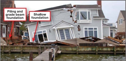
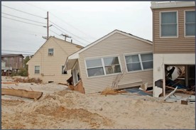
Figure 3a. On the left side of this image, a flow channel was formed during Superstorm Sandy due to a portion of the bulkhead being shorter than neighboring bulkheads. The house in the image was on a shallow foundation that was undermined and collapsed the house. The neighbor’s home survived due to its piling and grade beam foundation. This area was considered an AE 5 zone when Superstorm Sandy occurred with floodwater elevations to seven feet.1
|
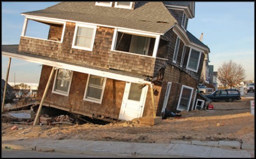
Figure 3b. This image was taken looking north toward the breach in Mantoloking. This house was built on shallow masonry foundations. During Superstorm Sandy, the house tipped into the secondary scour channel that formed on the north side of the house. This was an AE 5 zone and the Superstorm Sandy floodwater elevation reached seven feet in this area.1
|
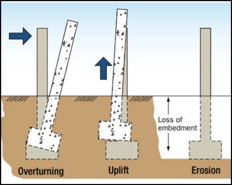
Overturning, Uplift, and Erosion of Piers
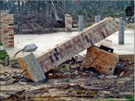
Figure 4a. This image was taken in Pass Christian, MS after Hurricane Katrina (2005). In the foreground, a pier on discrete footings failed due to rotating and overturning. In the background, one can see piers that remained intact because of the concrete mat. Discreet footings like the one seen in the foreground are acceptable only in areas where winds and flood loads are low and there is limited potential for erosion and scour.2
|
Figure 4b. This image shows different types of loads that piers are subject to, including upward, downward and horizontal loads. To successfully resist these loads, it is important to reinforce piers and use adequate footing size. If using masonry pier foundations, it is important to ensure the site is not in a V Zone, or in an A Zone subject to waves or erosion.3 |
|
 |
Shallow Pile Embedment
 |
|
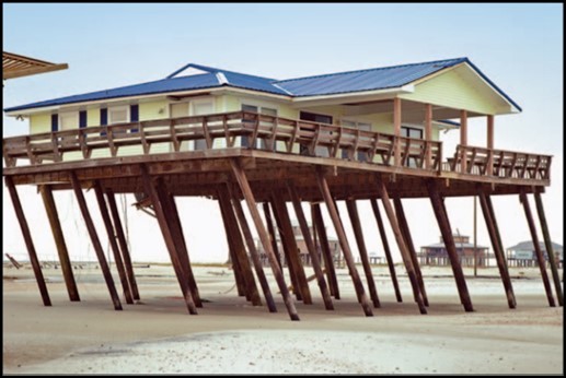
Figure 5a. The effectiveness of pile foundations is directly dependent on the pile material and size, and the pile embedment depth. This image shows piles that were inadequately embedded and do not have the structural capacity to resist sliding and overturning. This image was taken after Hurricane Katrina (2005) in Dauphin Island, AL.2 |
Figure 5b. Example of an inadequate pile foundation. In 2012, this house was in an AE 8 zone and Superstorm Sandy floodwater elevation reached eight feet. Since this house was on a low pile foundation, it was washed off its foundation and shifted toward a neighboring house in Beach Haven West, NJ.1 |
|
 |
Erosion Control Structure Failure
 |
|
Figure 6a. This image from Lavallette, NJ shows a timber bulkhead that was overtopped, backfill was lost, and the structure, approximately 15 feet landward of the bulkhead, was damaged during Superstorm Sandy. According to the Flood Insurance Rate Map (FIRM) at the time, this was an AO zone with flood depth one foot above the ground surface, and floodwater elevations reached nine feet during Superstorm Sandy.1 |
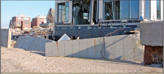
Figure 6b. This image from Seagate, Coney Island, NY shows a concrete seawall that failed during Superstorm Sandy, causing the house, approximately 15 feet landward of the wall, to be damaged. When Superstorm Sandy hit, this was considered to be a shaded X Zone, and during Sandy the floodwaters reached 13 feet. When the Advisory Base Flood Elevations were released, this area was considered a V 16 zone.1
|
1 Source: FEMA P-942 Mitigation Assessment Team Report Hurricane Sandy in New Jersey and New York
2 Source: FEMA P-55 Coastal Construction Manual Volume II - Principles and Practices of Planning, Siting, Designing, Constructing, and Maintaining Residential Buildings
3 Source: FEMA Technical Fact Sheet No. 3.4 in the FEMA P-499 Home Builder’s Guide to Coastal Construction, Technical Fact Sheet Series
Back to top.
By statute, FEMA modeling for new and revised floodplain maps does not consider the effects of sea level rise or increased storm frequency or intensity caused by climate change. In coastal areas, modeling relies upon simulations of past storm events, sea level measurements during historical coastal storms, and current landforms and topography. From this modeling, stillwater elevations (defined as the elevation of floodwaters exclusive of waves or seismic influence) during the 1% annual (100 year) flood are determined and wave set up and wave run up are determined to map V Zone and Limit of Moderate Wave Action lines. (Wave setup is defined as the increase in the water level caused by the onshore mass transport of water that happens due to waves breaking during a storm. Wave run up is the uprush of water above the stillwater level caused by wave action on a beach or shore barrier.) As sea levels rise, stillwater elevations will also rise, and modeling from wave setup and run up will enlarge and push V zone and Limit of Moderate Wave Action lines landward to account for waves that break further inland. Besides sea level rise, floodplain mapping also does not consider the following factors in Flood Insurance Rate Map maps:
- Shoreline erosion, wetland loss, subsidence, and relative sea level rise
- Upland development and/or topographic changes
- Degradation or settlement of levees and floodwalls
- Changes in storm climatology (frequency and severity)
- The effects of multiple storm events.
Current depictions of the 100-year floodplain and flood elevations will no longer be accurate as sea level rises. As discussed above, property owners should consider building stronger foundations now in areas with erodible soils in close proximity to current V and Coastal A Zones to avoid the impacts of sea level rise and future flood damage over the next 50 years. This will cost significantly less than the future cost of elevating these structures. The following section is an example to support stronger foundations in areas with erodible soils where current federal mapping may not represent future flood prone areas.
Back to top.
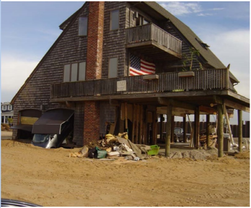
Figure 4. This photo is of “the Only House Still Standing” in Mantoloking, NJ after the barrier island was breached. In this area, the BFE elevation was an AE 5 and the floodwater elevation during Superstorm Sandy reached seven feet. One can see that the breakaway walls that were attached to the home’s pilings were washed away as intended and the house continued to stand on its deep piles. Photo Credit: Dr. Jon Miller, Stevens Institute of Technology, Hoboken
Nearly a decade after Superstorm Sandy, the story of the only house still standing at the Mantoloking breach serves as an example of why foundation design and construction – and hurricane evacuations – matter. FEMA produced a short video with the property owner on the decisions he made during construction and the outcomes after Superstorm Sandy. The Star Ledger Newspaper also wrote an article about this property. Both are noteworthy to help property owners visualize the damage and understand the emotional impact property owners experience from catastrophic flooding even when a resilient house works as designed. This case study will evaluate flood zones in this area and illustrate the concerns about erodibility and foundation design discussed in other sections of this article.
Property records indicate that this house was built in 1983. FEMA flood zones for this property have changed as follows:
|
Table 1: FEMA Flood Zones at the Case Study Property Since 1984
|
|
Map Date
|
Flood Zone
|
|
1984
|
A5 – Elevation 8 Feet NGVD29 (7 feet NAVD88 including the rounding up of the 1.2 foot vertical datum adjustment)
|
|
2000
|
AE6 NGVD29 (5 feet NAVD 88 with rounding) or AO-1 depending upon the siting of the house on the property
|
|
2006
|
AE5 NAVD88
|
|
Preliminary 2014
|
AE8 NAVD88
|
|
Land surface elevation in the area surrounding this house is approximately four feet NAVD88 as determined using LiDAR laser measuring methodology. Judging from post-storm pictures of the house, the lowest floor/living space of the house was at least nine feet above grade based upon standard building code practices for garages and floor joists. At approximately 13 feet NAVD 88, the lowest floor of this house was at least six feet higher than the base flood elevation at the time of construction required and is four feet higher than the current Flood Hazard Area Control Act and Uniform Construction Code minimum elevation.
|
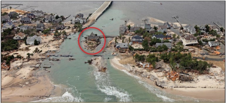
This property is not in an effective Coastal A zone, an area where 1.5 to 3-foot waves are predicted during the 1% annual (100-year) flood. It is not in the current 2014 preliminary map’s Coastal A zone. Until 2014, there were no Limit of Wave Action lines denoting Coastal A Zones in Mantoloking. More recently both the ocean and bayfront sides of the barrier island in Mantoloking have preliminary Coastal A Zones that, along with the State’s Flood Hazard Area Control Act rules and the Uniform Construction Code, require that lowest horizontal structural member be built to one foot above the preliminary map elevation and to ASCE 24-14 Chapter 4 construction standards. When the Coastal Restudy (make ) is completed, the flood zones in these new preliminary maps may change again given that modeling will consider a newly constructed $24M 3.5-mile-long steel revetment wall built after Superstorm Sandy. However, it is expected that most if not all of Mantoloking will remain in the Special Flood Hazard Area.
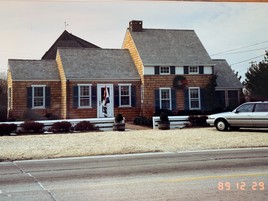
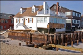
Figure 8a.This image is of the adjacent home east of the Case Study house which was built to AO-1 construction standards. Note the shallow foundation with no more than one or two steps up to the first floor of the house which would set its elevation at approximately 5 feet NAVD88 based upon LiDAR readings of 4 feet NAVD88 in this area. This house was destroyed during Superstorm Sandy, and is absent from the opening image of this newsletter. Source: Gary DalCorso, Mantoloking Tax Assessor.
|
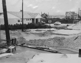
Figure 8b. Copy of a 1968 photo owned by the homeowner of the homeowner’s property showing severe flooding at the corner of Barnegat Lane and Mantoloking Road. Photo Credit: Tony Kurdzuk, The Star Ledger.
|
When coastal flood modeling is performed during FEMA map development, the overtopping of dunes during storm events is analyzed. Where this occurs in high elevation areas, AO zones are sometimes mapped to indicate areas of shallow flooding. AO zones also specify a number that indicates the feet above grade for establishing the lowest floor. On older FEMA flood maps in Mantoloking, houses built in AO-1 zones could have the lowest floors constructed one foot above ground elevation and built to the Uniform Construction Code requirements at the time of construction. In 2000, an AO-1 zone was designated on the property adjacent to the eastern side of the Case Study house. Figure 8a shows a house with a shallow foundation set at approximately 5 feet NAVD88. When designing the Case Study house in 1983, the homeowner notes that he could have built his house on a similar shallow foundation but, given the past flooding in the area shown in Figure 8b, he chose to build higher, on piles, and with breakaway walls. The house shown in Figure 8b, which was used as a real estate office, was destroyed during Superstorm Sandy as were several others from the ocean to the bay that were in A and V Zones.
While FEMA does not specifically discuss foundation construction in AO zones on barrier islands, it does acknowledge the vulnerability to erosion of X zones (areas high enough to be above the 1%/100 year base flood elevation) on dunes and bluffs. In Technical Fact Sheet 3.1, Foundations in Coastal Areas FEMA requires deep foundations (V zone construction) on dunes and bluffs when building site elevations are above the regulated 1% annual chance (100 year) floodplain and these areas are subject to wave action and erodibility during base flood event conditions. Because AO zones are mapped in most New Jersey coastal counties where FEMA’s coastal modeling indicates that storm surge and wave action overtops dunes during base flood events, design professionals should consider this warning and advocate for constructing deep foundations in AO zones where the erosion of a protective dune is possible. In this newsletter, the Case Study: The Only House Still Standing describes the vulnerability of shallow foundation construction in areas subject to wave action and erosion when the base flood event is exceeded. FEMA’s warning is as follows:
“In some instances, coastal areas will be mapped on an NFIP Digital Flood Insurance Rate Map (DFIRM) as Zone V but will have dunes or bluffs with ground elevations above the BFE shown on the DFIRM. During a design flood event, erosion of the bluffs and high dunes can be expected at these areas as well as waves and inundation. Therefore, the ground level can be expected to be lowered to a point that wave forces and loss of soil are a critical factor. The foundations for structures in these V Zone areas with high ground elevation are the same as V Zone areas with lower ground elevations. Deeply embedded pile or column foundations are still required in these areas, and solid or shallow foundations are still prohibited. The presence of a V Zone designation in these instances indicates that the dune or bluff is expected to erode during the base flood event and that V Zone wave conditions are expected after the erosion occurs. The presence of ground elevations above the BFE in a V Zone should not be taken to mean that the area is free from base flood and erosion effects.”
ASCE 24-14, Chapter C4 Coastal High Hazard Areas and Coastal A Zones, Section C4.1.1 also provides this warning:
“Proper application of this standard [ASCE 24-14 Chapter 4] may result in designing and constructing for high velocity wave forces even though a site has been designated as an A Zone by the NFIP. Designers using this standard should verify if high velocity wave forces are a significant design issue at a site before following the requirements of Chapter 2 or Chapter 4. Reliance solely on the V Zone and A Zone designations made by the NFIP may not be sufficient… it is possible that a structure located in an area designated by the NFIP as an A Zone will be subject to damaging wave forces.”
AO and X zones on dunes or erodible soils contained within in V Zones are required to have deep foundations (embedded at least 10 feet below mean water level per ASCE 24-14 Sections 4.5.1 and 4.5.5). By extension, any AO and X zones seaward of the LiMWA line in a Coastal A Zone with erodible soils would also have to meet this standard unless a site-specific geotechnical and structural analyses by a licensed design professional indicates that a shallow foundation can be safely constructed in erodible soils (see above discussion entitled “Erodible Soils in New Jersey’s Coastal High Hazard and Coastal A Zones”).
Because erodible soils are extensively mapped throughout New Jersey’s coastal floodplain, design professionals are encouraged to evaluate soil conditions and consider specifying deep foundations for properties in X, A, and AO zones where current FEMA mapping or the minimum Uniform Construction Code standards do not require them. Planning for stronger foundations during construction, like the homeowner of this Mantoloking house did, is a climate change adaptation and resiliency strategy that will help avoid future property damage and structural failure as sea level rises and storm events increase in duration and severity.
 |
|
Figure 9a. After Superstorm Sandy
Image taken after Superstorm Sandy showing the only house still standing and the absence of houses surrounding it.
Source: Dr. Stewart Farrell, Stockton University
|
|
Figure 9b. Structure Rebuilt
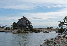
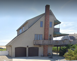
Image of “the Only House Still Standing” after post-storm restoration. Estimated lowest floor elevation is 13 feet NAVD88. Image from July 2019.
Source: Google Street View
|
|
 |
“The Only House Still Standing” after Superstorm Sandy where the Atlantic Ocean met the Barnegat Bay in Mantoloking should serve as a warning to property owners building on erodible soils on New Jersey’s barrier islands and bayfronts that they risk significant losses if they construct on inadequately designed foundations in erodible soils. Local floodplain administrators should advise property owners that both FEMA and ASCE 24-14 encourage deep foundations in erodible soils in A zones that are not part of V Zones or Coastal A Zones when erosion of protective dunes and bulkheads is possible or stillwater elevation analysis indicates these areas could be subject to wave action. Floodplain Administrators should also advise property owners that FEMA estimates structures in the Special Flood Hazard Area have a 26% chance of flooding that over the life of a typical 30-year mortgage.
The owner of this Mantoloking property experienced an unimaginable catastrophic flood event at the very end of what would be a 30-year mortgage timeframe. Fortunately, the breakaway walls separated as designed; the pilings held when bashed by his truck; the undermining of the garage slab didn’t damage his home even though his car was destroyed; and the two feet of sand that ended up under his house was easily removed. Though unknowable amounts of water passed under his house and countless debris strikes pounded against his house’s piles as his neighbors’ houses broke apart in the waves, his house stood tall and was rebuilt to last.
Back to top.
Back to top.
Since its inception in 2004, the New Jersey Association for Floodplain Management has been a strong partner with the DEP in promoting the mutual goal of promoting sound floodplain management in New Jersey. New Jersey Association of Floodplain Management is a state chapter of the national Association of State Floodplain Managers, the most respected voice in floodplain management practice and policy in the United States. New Jersey Association of Floodplain Management also collaborates with the Federal Emergency Management Agency on a range of federal floodplain management issues, including the National Flood Insurance Program, flood mapping, outreach and education.
New Jersey Association of Floodplain Management provides technical training and educational opportunities for municipal floodplain managers, construction code officials and other public and private sector professionals working in the field of floodplain management. The New Jersey Association of Floodplain Management annual conference also provides a forum for sharing information and experiences with local, state, regional, and federal officials, industry leaders, consultants and a wide variety of subject matter experts from diverse fields.
New Jersey Association of Floodplain Management welcomes the opportunity to further our partnership with the DEP and FEMA, and invites interested parties to work with us on floodplain management issues that will enhance public safety, maintain the functions and values of natural resources, and ensure compliance with state and federal floodplain requirements. Check www.njafm.org for more information.
Back to top.
|