 Tropical Storm and Storm Surge warnings are currently in effect for Dare County, indicating that tropical storm force winds and life-threatening inundation from rising water will reach the area within the next 36 hours.
Dare County remains under a State of Emergency, and a Mandatory Evacuation order remains in effect for all areas of Hatteras Island (Hurricane Evacuation Zone A), which includes the villages of Rodanthe, Waves, Salvo, Avon, Buxton, Frisco and Hatteras.
If you are still on Hatteras Island and have not yet evacuated, now is the time to do so. The window to safely evacuate is closing quickly, as coastal flooding and overwash is already beginning to occur along vulnerable stretches of N.C. Highway 12—and is expected to continue to worsen with the approach of today’s high tide (Tuesday, August 19, 2025 at approximately 5 p.m.).
Once coastal flooding begins, inundation will persist for several days, worsening with each high tide. N.C. Highway 12 is expected to become impassable, making it extremely difficult—if not impossible—for emergency services personnel to respond to calls for service.
Although the most severe impacts from Hurricane Erin are expected on Hatteras Island, residents and visitors north of Oregon Inlet—especially those staying along the oceanfront—should remain alert. Be mindful of rising ocean waters as the storm passes offshore and be ready to take necessary precautions, such as moving vehicles to higher ground.
 Swimming Prohibition (Countywide):
Due to life-threatening ocean conditions—including rip currents and extremely hazardous surf and large breaking waves—double red flags have been posted throughout all Dare County beaches by local ocean rescue agencies, indicating that no one may enter the waters of the Atlantic Ocean anywhere in Dare County. This prohibition includes swimming with or without flotation devices, rafts, or other aids. A violation of this restriction is punishable as a Class 2 misdemeanor in accordance with G.S. 14-288.20A
-
Surfing Exception: Entry with a surfboard is permitted. A surfboard is defined as a fiberglass and foam combination at least five feet in length, having a minimum of one fin, and used in conjunction with a leash.
Updates from Dare County Schools & Municipalities:
Town of Duck
Hurricane Erin will bring hazardous ocean conditions beginning Tuesday, August 19, 2025 into Thursday, August 21, 2025. If red flags are flying, stay out of the ocean! Protect your life and the lives of others.
During periods of high surf, the beach can be hazardous. Powerful waves and currents can knock people down quickly. Keep a safe distance from the water.
In preparation for high surf, lifeguard stands are being temporarily removed to prevent damage. Residents and visitors are asked to exercise caution in oceanside areas while Ocean Rescue crews work to safely remove the stands.
As tropical storm force winds are expected, please secure all loose outdoor items. Strong winds and flooding can turn unsecured objects into hazards. Take a few extra minutes to ensure your property is safe.
National Hurricane Center and National Weather Service-issued advisories, watches, and warnings can be found here.
Sign up to receive customized alerts at www.OBXAlerts.com or by texting OBXBeachConditions to 77295.
For more information, visit the Town of Duck.
Town of Kitty Hawk
Lifeguard stands have been removed from the beach and Ocean Rescue is operating via roving patrol. Trash collection for the Town of Kitty Hawk will operate on a regular schedule.
Oceanside, and especially oceanfront, properties in Kitty Hawk are at significant risk of becoming inaccessible due to hazardous ocean conditions starting as early as Wednesday afternoon, August 20, 2025 as Hurricane Erin moves along the North Carolina coast. These conditions may persist for several days, and the forecast may change.
If you are not comfortable staying in your oceanfront property, please leave prior to Wednesday afternoon.
Currently, there is no mandatory evacuation order for Kitty Hawk. However, those staying on the oceanside or oceanfront should have a go-bag ready in case they need to leave their property quickly. After dark on Wednesday, August 20, occupants should remain in their properties as travel is expected to become hazardous.
If these properties are surrounded by hazardous ocean water, public safety personnel may have difficulty responding to fire, medical, and law enforcement emergencies.
Vehicles parked near the ocean may also become surrounded by water. If you wish to move vehicles to higher ground, we have identified alternative parking locations. Vehicles may be parked in the gravel lot at Holy Redeemer Catholic Church located at 301 West Kitty Hawk Road and at Kitty Hawk Police Department building located at 5200 North Croatan Highway in the rear parking lot behind Bear Drugs.
During periods of high surf, the beach will become unsafe, even for walking. Keep in mind that it doesn’t take much for strong waves and currents to sweep someone off their feet.
For more information, visit the Town of Kitty Hawk.
Town of Kill Devil Hills
Beach Safety: In anticipation of Hurricane Erin’s impacts, the Town of Kill Devil Hills is removing lifeguard stands and beach trash cans as part of storm preparations. While conditions allow, lifeguards will continue to patrol the beach by vehicle. If you do not see a lifeguard and have an emergency, call 9-1-1.
Double red flags are flying in Kill Devil Hills. Double red flags mean that swimming is prohibited. Ocean conditions will continue to deteriorate and make the water unsafe for everyone. Don't risk your life or someone else's. Stay safe, stay out of the ocean!
We are expecting waves of 15 to 20 feet in the surf zone, along with significant wave run-up. This means the water will surge high up onto the beach, and with little time between sets, it won’t fully recede before the next powerful wave arrives. This creates an extremely dangerous situation — even walking the beach can be life-threatening. The combination of rip currents, powerful shore break, and fast-moving water can knock you off your feet or sweep you into the ocean.
As conditions worsen with the approaching storm, please exercise extreme caution when near the ocean.
Secure Outdoor Items: As you make final storm preparations, be sure to secure all loose outdoor items. Strong winds and flooding can turn unsecured objects into hazards. Some items to double-check include trash and recycling cans, pots and planters, toys, grills, tables and chairs, and lawn décor.
Stay Informed: Stay informed and follow guidance from local officials and trusted sources. If you live, work, or visit Kill Devil Hills or Dare County, sign up for official emergency alerts: www.OBXAlerts.com. Additionally, for your safety, it's important to have multiple ways to receive warnings. Make sure at least one can wake you up.
For more information, visit the Town of Kill Devil Hills.
Town of Manteo
Town of Manteo municipal operations staff are monitoring the storm track and will be available to address any emerging hazards from Hurricane Erin. We encourage our community to check all disaster kits now to ensure that necessary items are available. At this time, the current NWS Hurricane Erin wind forecast does not predict that soundside flooding will affect Manteo. We recommend that the community remain inside when conditions become dangerous for walking/driving, and please observe the following safety tips:
Stay clear of fallen/low hanging power lines – they may be energized and dangerous.
Do not drive around barricades or through standing water.
Stay clear of unstable hanging branches or fallen limbs.
Report any utility interruptions to the service provider.
Sign up for NC FIMAN alerts to receive Manteo soundside flooding notifications at https://fiman.nc.gov.
For more information, visit the Town of Manteo.
Town of Nags Head
The Town of Nags Head would like to reiterate that oceanside, and especially oceanfront, properties in Nags Head are at significant risk of becoming inaccessible due to hazardous ocean conditions starting as early as Wednesday afternoon, August 20, 2025 as Hurricane Erin moves along the North Carolina coast. These conditions may persist for several days, and the forecast may change.
If you are not comfortable staying in your oceanside or oceanfront property, please leave prior to Wednesday afternoon.
We do not currently expect a mandatory evacuation. However, those staying on the oceanside or oceanfront should have a go-bag ready in case they need to leave their property quickly. After dark on Wednesday, August 20, 2025, occupants should remain in their properties as travel is expected to become hazardous.
If these properties are surrounded by hazardous ocean water, our public safety personnel may have difficulty responding to fire, medical, and law enforcement emergencies.
If you wish to move vehicles to higher ground, we have identified alternative parking locations. In north Nags Head, parking will be available at Town Park, Dowdy Park, and the north lot of The Soundside Event Site. In south Nags Head, parking will be available at several beach accesses with high dunes in front of them: Holden, Hargrove, Islington, Indigo, June, and Jacob. The Ida beach access will not be available as Town equipment will be temporarily staged there. The Juncos beach access is not recommended due to the possibility of ocean overwash.
The Stormwater Master Plan Open House, originally scheduled for Thursday, August 21, 2025 has been moved to Tuesday, August 26, 2025 from 5:30 p.m. to 7 p.m.
For more information, visit the Town of Nags Head.
Dare County Schools
As we prioritize the safety of our students, staff, and community, please review the updated schedule for this week, including changes to workdays, athletics, and open houses.
Workdays for Staff
-
Tuesday, August 19, 2025 – Optional Workday for Cape Hatteras Schools; Required Workday for schools north of Oregon Inlet; Optional Workday for Dare Early College
-
Wednesday, August 20, 2025 – Cape Hatteras Schools closed; Optional Workday for schools north of Oregon Inlet; Remote Learning for Dare Early College
-
Thursday, August 21, 2025 – All Dare County Schools closed (including Dare Early College) for staff and students
Athletics: Games and Practices
-
Tuesday, August 19, 2025 – Athletics to continue north of Oregon Inlet only
-
Wednesday, August 20, 2025 – No athletics
-
Thursday, August 21, 2025– No athletics
Open Houses
-
Thursday, August 21, 2025 – Postponed; individual schools will announce new dates
We will continue to monitor conditions closely and share any updates including Friday’s schedule as soon as we have a clearer understanding of the storm’s impacts.
Thank you for your patience, flexibility, and support as this storm continues to develop and we work together to keep our students and staff safe.
For more information, visit Dare County Schools.

Dare County Offices & Facilities Closures:
Due to expected impacts from Hurricane Erin and the Mandatory Evacuation order for all of Hatteras Island, Dare County offices and facilities south of Oregon Inlet will remain closed until the evacuation order is lifted. County offices and facilities north of Oregon Inlet will be operating business as usual unless otherwise noted. Find additional closures, cancellations or changes to Dare County schedules on DareNC.gov/HurricaneErin.
Dare County Public Works
Due to expected impacts from Hurricane Erin, there will be no commercial trash collection on Hatteras Island on Wednesday, August 20, 2025.
The Buxton Transfer Station closed at 12 p.m. on Tuesday, August 19, 2025 and will remain closed until further notice.
All areas north of Oregon Inlet, both residential and commercial, whose trash collection is provided by Dare County Public Works are expected to remain on their normal trash collection schedule all week. To view Dare County’s residential and commercial trash collection schedule, please visit DareNC.gov/Trash.
Should there be any changes to the schedule, that information will be posted on DareNC.gov/HurricaneErin.
Dare County Water Department
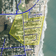
Due to concerns related to ocean overwash, the Dare County Water Department will be shutting off water to an area located south of N.C. Highway 12 and along Old Lighthouse Road in Buxton [see highlighted area in image] by 5 p.m. on Wednesday, August 20, 2025. Please note, however, that conditions may require it to be shut off sooner. Water will be restored to this area as soon as it is safe to do so. An alert has been sent to affected Dare County Water customers who are located in the designated area. For more information, please contact the Dare County Water Department at Water@DareNC.gov or 252-475-5990.
|
The Dare County Water Department's billing office located in Frisco (50225 Water Association Road, Frisco, NC 27936) is now closed and will remain closed until further notice.
Should there be any additional changes, that information will be posted on DareNC.gov/HurricaneErin.
Stay Informed & Prepared:
Sign Up for Local Alerts:
-
Emergency Alerts: Sign up to receive customized alerts—including severe weather watches and warnings, evacuation orders, and other time-critical notifications—at www.OBXAlerts.com
-
Beach & Ocean Conditions: Get daily beach condition updates via text by texting “OBXBeachConditions” to 77295. For rip current safety, red flag warnings, and more, visit www.LoveTheBeachRespectTheOcean.com
Dare County Emergency Management will continue to issue periodic updates, with the next update scheduled no later than Wednesday, August 20, 2025 at 4 p.m.
|