|
The Lessard-Sams Outdoor Heritage
Council recently issued its request for 2016-‘17
funding proposals. The grants are for projects that protect, restore and enhance
wetlands, prairies, forests, and habitat. The council expects
about $100 million to be available for projects starting July 1, 2016. The
council may revise this estimate after November 2015. Submissions are due June 4, 2015 and must be done electronically.
Council staff are
available to assist applicants. Anyone wanting proposal writing assistance can
contact staff at 651-284-6430 to set up an appointment.
The council makes annual
recommendations to the Minnesota Legislature on appropriations from the Outdoor
Heritage Council, which is funded by the Clean Water, Land and Legacy
Amendment.

The
Minnesota Pollution Control
Agency (MPCA) has awarded nine Surface Water Assessment Grants (SWAG) for the 2015-2016
monitoring seasons. Each year the MPCA
seeks local assistance for water quality monitoring in accordance with its
Intensive Watershed Monitoring Plan. With this plan, the MPCA has assigned a
year to each of the 81 major watersheds in the state for sampling during a
10-year cycle. For 2015-2016 funds have been provided to assist with monitoring
in the following watersheds:
-
Cloquet River
- Lac Qui Parle
- Minnesota River Headwaters
- Mississippi River-Grand Rapids
- Mississippi River-La Crescent
- Mississippi River-Reno
- Rainy River
- Roseau River
- Upper Iowa River
- Vermilion River
The amount of $445,000 has been awarded to:
- Aitkin County Soil and Water Conservation District (SWCD)
- Carlton County SWCD
- Headwaters Science Center
- Itasca County SWCD
- Lac Qui Parle – Yellow Bank Watershed District
- North St. Louis SWCD
- Regents of the University of Minnesota Natural Resources Research Institute
- Root River SWCD
- Roseau County SWCD
SWAGs provide local governmental units, non-profit organizations, American Indian Tribal governments, and colleges and universities with funds to gauge the health of lakes and streams. Additionally, grant dollars provide funding for training, citizen volunteer programs, equipment, and lab analysis of water samples.The MPCA works with partners and citizens on the local level to identify healthy lakes and streams that need protection. They also identify waters that fail to meet state standards and require restoration. The data collected help set priorities for the agency and funding sources like the Clean Water Land and Legacy Amendment.
|
Recent testing by the MPCA shows three northeast
Minnesota watersheds have good-to-high water quality - and that’s great news
for people seeking a quality wilderness experience.
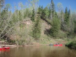
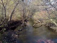
In the Lake
Superior-South watershed, along the North Shore, and the Big
Fork River watershed, in Itasca and Koochiching Counties, the high water
quality may be due to high levels of undisturbed land. The mostly-undeveloped Nemadji
River watershed, straddling the Minnesota-Wisconsin border near Duluth, is
covered by forests and wetlands, including state forests, wildlife management
areas and other public lands. (Photo at right shows paddlers on the Nemadji.)
Some of the cleanest waters in the Lake
Superior-South watershed have excellent fish and aquatic invertebrate
communities and the habitat required to sustain them.
A large majority of the Big Fork River system is
in excellent condition; it is one of the healthiest watersheds in the state
with more than 150 stream miles that support recreation and aquatic life. More
than 100 lakes met recreation- based standards including Turtle, North Star and
Gunn.
Although water quality monitoring results show a
different story in the Nemadji, there are some bright spots to be found in the
watershed, including State Line Creek and the Net River.
Additional testing should determine whether
problems such as excess sediment, bacteria and mercury have natural or human
causes.
For more information, visit www.pca.state.mn.us and search by the
watershed’s name.
|
The MPCA recently released its
proposal for protecting wild rice from excess sulfate. Rather than relying on a
single sulfate level for all wild rice waters in the state, the agency proposes
to calculate a sulfate level for each wild rice water, based on
location-specific factors.
The MPCA’s study of how sulfate
affects wild rice, which began in 2012, finds:
-
In the sediment in which wild rice is rooted, sulfate from the water above is converted to sulfide by bacteria
- Higher levels of sulfide in the
sediment create an environment that is less hospitable to wild rice
However, certain factors change
the rate at which sulfate is converted to sulfide. Most significantly, higher
levels of iron can lead to less sulfide, and higher levels of organic carbon
can lead to more sulfide.
To take these variables into
account, the MPCA developed an equation that can determine a sulfate level that
will protect wild rice for a specific water body. The agency proposes
collecting sediment samples in wild rice stands, measuring the iron and organic
carbon concentrations in the sediment, and then plugging the data into the
equation to calculate a protective sulfate concentration for that particular
wild rice water.
The MPCA will be scheduling
meetings with interested stakeholders to further describe and get input on its
proposal. The agency will continue to refine the proposal based on feedback and
any new data. At the same time, the MPCA will consider how the study’s findings
will inform regulatory decisions and develop the data collection protocol
needed to implement the proposal. The MPCA plans to go through formal rulemaking
to change the existing standard later this year. The rulemaking will also
include listing specific wild rice waters that are subject to the standard.
The MPCA has compiled a draft
list of wild rice waters, along with a process to add waters to the list over
time. The list and process are available on the MPCA's draft
proposal for wild rice webpage. The MPCA also proposes that a sulfate
standard is not needed to protect commercial wild rice paddies.
|
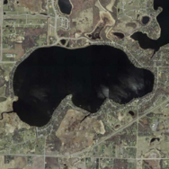 The
MPCA is inviting the public to comment on a revised water quality standard
proposed for Spring Lake in
Scott County. The proposed water quality target is specific to this lake, and
is meant to address problematic levels of nutrients — specifically phosphorus —
in the lake.
Spring Lake is located in the city of Prior Lake and Spring Lake Township. It
is popular for recreation and fishing. However, because of its excess
phosphorus levels, Spring Lake suffers from algal blooms and diminished
clarity, which makes the lake less suitable for recreation.
MPCA staff are proposing a site-specific water quality target for Spring Lake
because of new information about historic in-lake phosphorus concentrations
dating back nearly 200 years.
The Prior Lake-Spring Lake watershed district conducted a lake sediment core
study, which revealed that historic total phosphorus levels in the lake were
approximately 60 micrograms per liter even prior to European settlement of the
area in the mid-1800s, which led to significant changes in land use. In response
to this study, MPCA staff believe it is reasonable to treat this concentration
of phosphorus as a natural background condition and, therefore, the best
phosphorus level that this lake could be expected to achieve.
A public informational meeting to discuss the proposed standard is planned for
April 14, 2015 at 6 p.m. The meeting will be held at Prior Lake City Hall, 4646
Dakota Street Southeast in Prior Lake.
|
The MPCA invites comments on two reports outlining strategies to restore
the Le
Sueur River watershed. The reports are open for comment through April 29.
The Le Sueur watershed covers 711,000 acres in south-central
Minnesota. It drains parts of Blue Earth, Faribault, Freeborn, Steele and
Waseca counties. Near Mankato, this river meets the Blue Earth River, a
tributary to the Minnesota River.
This watershed is one of the highest polluting watersheds in
Minnesota, according to data collected statewide. Impairments – waters that
fail to meet standards – are common throughout the watershed.
In this first cycle of
intensely studying the watershed:
-
Of the 11 lakes examined in the watershed, two supported aquatic recreation — St. Olaf and Reeds. Five were impaired due to high nutrient levels, and four need more data to determine their status.
- Of the 74 stream sections examined, only one — in the Cobb River — supported aquatic life.
Twenty-one were impaired and 12 need more data to determine their status. Forty
have been altered significantly so the MPCA is deferring assessment.
Under federal and
state laws, impaired waters must have Total Maximum Daily Load (TMDL) studies to
determine reductions of pollutants needed to again meet water quality
standards. In this first WRAPS cycle, the MPCA completed TMDL studies for four
lakes and six stream sections. In addition to these lakes and stream sections,
the MPCA has completed a TMDL study for Lura Lake in the watershed and is
working to complete a TMDL study of turbidity in the Le Sueur River as part of
the greater Blue Earth River System.
Comments on the reports,which
are available online, are due by 4:30 p.m. on April 29, to Paul Davis, MPCA
project manager, at paul.a.davis@state.mn.usor
12 Civic Center Dr., Ste. 2165, Mankato, MN. Davis can be reached at
507-344-5246 or 800-657-3864.
|
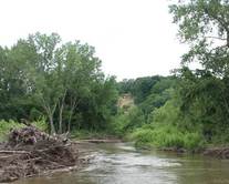
The MPCA is seeking comments on a watershed
restoration and protection report for the Buffalo River Watershed. The
report, known as a Watershed Restoration and Protection Strategy (WRAPS),
summarizes monitoring and water quality improvement projects completed during
the past several years, and identifies strategies necessary to restore and
protect the water quality of streams and lakes in the watershed. Comments on
the report are being accepted through April 29.
The Buffalo River watershed covers more than 1,100 square miles
in portions of Clay, Becker, Wilkin and Otter Tail counties in western
Minnesota.
The WRAPS report includes a Total
Maximum Daily Load (TMDL) study. A TMDL study establishes the maximum
amount of a pollutant a water body can receive on a daily basis and still meet
water-quality standards. The Buffalo River TMDL identified pollution resulting
from excess nutrients, E. coli bacteria, turbidity (reduced light penetration
of water due to suspended solids) and low dissolved oxygen. In addition to
these impairments, the study identified locations where conditions make it
difficult to support aquatic insects (macro invertebrates) and fish. The TMDL
study is also available for public review and comment.
The draft WRAPS report and TMDL study are available on the
MPCA’s Buffalo River Watershed
webpage.
Written comments should be mailed to Tim James, MPCA, 714 Lake
Ave., Ste., 220, Detroit Lakes, MN 56501, or sent by email to tim.james@state.mn.us. They must be
received by 4:30 p.m. on April 29, 2015.
|
How to provide comment
Written comments on draft reports and standards must include a statement of your interest in the report; a statement of the action you wish the MPCA to take, including specific references to sections of the draft you believe should be changed; and specific reasons for your position.
The
MPCA will hold a “Chloride Extravaganza” to to introduce the Chloride
Management Plan and TMDL for the Twin Cities Metro Area on April 28 from 1-4:30
p.m. at the Dakota Lodge, 1200 Stassen Lane, West St. Paul. The agency will discuss
the environmental impacts of chloride, the current water quality conditions in
the metro area, and the draft management plan developed to reduce chloride at
the source.
The
agenda includes:
-
Water quality impacts of chloride;
- Chloride management strategies, resources, and tools; and
- Chloride TMDL and permit implications.
Please
RSVP by clicking here. For more information, visit the project webpage. Draft documents will be available
soon.
The third Minnesota River Congress will convene Thursday,
April 16 at Turner Halle in New Ulm. The purpose will be to decide on a
mission, organizational structure, objectives, guiding principles and ground
rules for future meetings.
Doors will open at 4:30 p.m. for a networking fair with
displays and representatives from organizations active in the Minnesota River
basin. A burger bar buffet will start at 6 p.m. Results from prior congresses
will be reviewed at 6:45 p.m. The full session begins at 7 p.m. and will
adjourn at 9 p.m.
The third congress will build from previous congress
meetings June 19 and Oct. 30, and six regional meetings. It is open to everyone
interested in the economic, social, and natural resource vitality of the basin,
encompassing nearly 11 million acres, more than 700,000 people, and thousands
of farms and industries.
Within Minnesota it includes all or portions of 37 counties
and more than a hundred cities and towns. All depend on its land and water. The
people in the basin are represented by one or more of the many organizations in
the basin. Yet there is no collective voice speaking solely for the land and
water throughout the entire basin, for what they need to stay healthy and
productive.
Organizers believe there’s a need for a citizen-led
entity that is inviting and all inclusive for the many different groups active
in the Minnesota River Valley, including agriculture, industry, natural
resources, recreation, economic development, tourism, all levels of government,
faith communities, first nations, and watershed organizations.
Cost per person is $15 in advance and $20 at the door.
Networking booth space is available on a limited basis for $30. Checks made to
Coalition for a Clean Minnesota River can be mailed to PO Box 488, New Ulm, MN
56073. Tables will be provided. You can register individually online using Paypal.
|
The
Mississippi River Forum will present “"No
such thing as wastewater: St. Cloud's innovations in resource recovery" on
Friday, April 24 from 8-9:30 a.m. in St. Cloud and Friday, June 19 from 8-9:30
a.m. in Minneapolis. The City of St. Cloud recently completed a
pilot study to show that phosphorus fertilizer can be harvested from wastewater.
This study could enhance an already successful biosolids management program by
creating additional uses for recycled waste.
There
is no admission for the program or the light breakfast served, but an RSVP is
required to Lark Weller of the National Park
Service.
Details, including how to join the meeting
via a webinar or call-in, are available on the Mississippi River
Forum webpage.
The
MPCA is proud to be a partner in several projects nominated for Environmental Initiative Awards,
including the following:
-
Minnesota Ag Water Quality Certification Program;
- Phosphorus reduction by cover crop;
- Science Museum of Minnesota: Project no waste; and
- Hennepin County Master
Recycler and Composter program.
The non-profit
group will announce the winners May 21. Details available on the Environmental
Initiate website.
The U.S.
Environmental Protection Agency recently approved the TMDL
for Rice Creek Watershed District southwest urban lakes. This
project addresses excess nutrients in Island Lake, Little Lake Johanna, Long
Lake, Moore Lake, Pike Lake and Lake Valentine. These waterbodies and the land
area that drains to them are located in the southwest portion of the Rice Creek
watershed in Ramsey and Anoka counties. Phosphorus loads in the lakes need to
decrease by 25-55 percent for them to meet water quality standards.
"Dayton proposes more money to reimburse farmers for buffers" in the Pioneer Press
“Buffers:
Greatest opportunity in southern, western Minnesota” on the MPCA website
“Buffer
bill draws criticism, support” in Agri-News
“MN's
St. Louis River listed among nation's most endangered” on Minnesota Public
Radio
"Study: Minnesota converted most wetlands between 2008-2012" in the Washington Times
“Town's
contaminated water highlights a larger problem for Minnesota” in the StarTribune
|