March 2015
Welcome to the first edition of Watershed Connections. This combines two previous newsletters, River Connections and Watershed Network News, and will be issued monthly. While many subscribers received both previous newsletters, the combined distribution list now exceeds 2,100. Thank you for your continued interest. We will strive to continue providing accurate, timely, and interesting news about water quality issues in watersheds comprising the Minnesota, Lower Mississippi, and Crow river basins.
The
greatest opportunity to improve buffers around water resources in Minnesota is
in the southern and western parts of the state, where about half the shorelines
need buffer coverage, according to Dept. of Natural Resources (DNR). Much of
the Crow and Minnesota river watersheds are in this area.
In
central and east central Minnesota, including much of the Lower Mississippi
basin, almost 90 percent of the shorelines have good or very good buffers in
place.
The
DNR recently launched a website on Gov. Mark Dayton’s proposal to require a 50-foot
buffer around lakes, rivers and streams. Earlier this month, Dayton introduced
legislation (HF1534/SF1537) – co-authored by Rep. Paul Torkelson
and Sen. John Marty – to mandate the buffers for the protection of water
quality and habitat.
“The state’s existing rules on buffer strips are inconsistent, and they
are enforced inconsistently – which almost always guarantees failure,” Dayton
said. “The strengths of my proposal are its simplicity and common sense. People
have the right to do lawful practices on their private properties;
however, they should not have the right to contaminate waters that all of us
depend upon.”
Buffer strips
are designed to help filter out phosphorus, nitrogen, and sediment by slowing
runoff and trapping polluted sediment. Buffer strips then allow vegetation to
absorb any pollutants, preventing them from entering the water supply.
Statewide, the proposal would require that 125,000 acres of land adjacent to
water be designated for buffer strips, and covered in permanent vegetation.
The DNR would
be responsible for enforcing the new law. The new law would provide a simple, uniform
buffer requirement across all of Minnesota's waters. It does not alter existing
shoreland rules or drainage law.
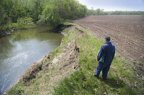
Photo above: Planting to
the edge of a riverbank, a violation of the current buffer strip rule, is
common in many places in Minnesota, including the Maple River watershed. (MPCA
photo)
Back to top
|

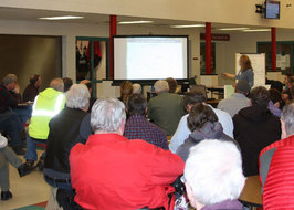
A full house at the
Waseca County Farmers’ Forum at FarmAmerica March 11 offered many questions on the
ditch buffer issue. Jason Garms, the new ag liaison for the DNR, gave an
overview of the buffer laws and rules, and the recent initiative to revise and
enforce the rules. Here is a sample of paraphrased questions and Garms’
responses (in parentheses):
-
What is the true source of the initiative? (DNR roundtables, pheasant summit).
- Will this create more relationship challenges between local agencies and landowners? (Most landowners know their local SWCD staff. They are not enforcers, but helpers).
- What are the incentives, what are farmers getting for losing cropland? (Maintain eligibility for cost-share programs, opportunity to be pro-active, avoid legal challenges, good public relations).
- Many ditch buffers are bermed and there is no runoff. (There is flexibility for alternative practices).
- How is water quality defined? (There are current impairment categories and levels).
- What about sediment? We can’t protect all the banks against high flows. (The buffer initiative is not about
levels of water quantity).
Following the ditch buffer
discussion, several speakers from Iowa gave presentations and took questions
about a market approach to wetlands establishment, prairie strips between row
crops, and saturated buffers. Several organizations were present with displays
and information tables. (Photo: Kay Clark talks with a visitor at the Greater
Blue Earth River Basin Association table.)
Back to top
|
Related stories and studies:
The Minnesota Pollution Control
Agency (MPCA) invites comments on two reports outlining strategies to restore
the Le
Sueur River watershed. The reports are open for comment March 30– April 29.
This watershed is one of the
highest polluting watersheds in Minnesota, according to data collected
statewide. Impairments – waters that fail to meet standards – are common
throughout the watershed.
The Le Sueur watershed covers
711,000 acres in south-central Minnesota. It drains parts of Blue Earth,
Faribault, Freeborn, Steele and Waseca counties. This river meets the Blue
Earth River near Mankato, where drinking water wells extract water from below
the Blue Earth River.
The MPCA and local partners
have intensely monitored waters in the Le Sueur drainage area and assessed them
to see if they meet state water quality standards. They have also identified
conditions that stress fish and other aquatic life, as well as conditions that
support this life and other benefits. The agency has drafted Watershed
Restoration and Protection Strategies for the Le Sueur area as a whole.
It has also drafted Total
Maximum Daily Loads (TMDLs), which are the maximum amounts of pollutants
that water bodies can accept and still meet standards, for six sections of
streams and four lakes:
-
Little Cobb River, from Bull Run Creek to the Cobb River, for low dissolved oxygen related to nutrient levels. Reductions in phosphorus from nonpoint sources such as field runoff and from point sources such as wastewater are needed to meet standards.
- Parts of the Le Sueur River, Boot Creek, Rice Creek, County Ditch 3 and Cobb River for bacteria levels. Reductions of 19 to 70 percent are needed to meet standards.
- Madison, Elysian, Eagle and Freeborn lakes for nutrient levels. Reductions of 61.8 to
73.5 percent are needed to meet standards.
Major stressors in this
watershed include these interrelated factors:
-
Changes to the watershed’s hydrology.
- Lack of habitat.
- High nutrient levels. Nutrients can lead to algal blooms that can harm aquatic life such as fish and recreation such as swimming.
- High turbidity levels. Turbidity is a measurement of how cloudy or muddy water is,
with standards set for clearer water to support aquatic life and recreation.
A main strategy to restoring
waters in this area is mitigating the changes in hydrology through conservation
tillage, water retention basins, restored wetlands, controlled drainage and
other methods. Other strategies include buffers along waterways, streambank
stabilization, septic system upgrades and stormwater management.
Comments on the reports,
which are available online, are due by 4:30 p.m. on April 29, to Paul Davis,
MPCA project manager, at paul.a.davis@state.mn.us
or 12 Civic Center Dr., Ste. 2165, Mankato, MN. Davis can be reached at
507-344-5246 or 800-657-3864.
Written comments must include a
statement of your interest in the report; a statement of the action you wish
the MPCA to take, including specific references to sections of the draft report
you believe should be changed; and specific reasons for your position.
Back to top
|
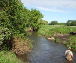
 More than 75 people from across the LeSueur River watershed met March 24 in St. Clair to learn and discuss water management issues. Brooke Hacker and Scott
Bohling, of the DNR, discussed flow trends and widening channels in the system. Chuck Brandel, engineer with I+S Group, described multipurpose drainage systems designed for temporary water storage during storm events.
Following the speakers, participants engaged
in group discussions about the Network Steering Committee’s ideas to start working on the Seven Recommendations for cleaner water and river
health in the Le Sueur River watershed. Ideas include: 1. Narrow focus to
2-4 subwatersheds; 2. Prioritize
Recommendations #1 (More stormwater management and more in-ditch storage) and
Recommendation #2 (More experimentation with temporary water storage); and 3.
Keep meeting, talking and learning together. There was general consensus on these three approaches for moving forward.
Currently
the network is partnering with Faribault County SWCD on a Community Partners
Grant for stormwater management projects across the watershed.
Coordinating staff and Network Steering Committee members are using their three
approaches outlined to target projects eligible for funds from the Community
Partners Grant. For more information about the Le Sueur River Watershed Network, visit lesuerriver.org or contact Jessica Nelson, jessica.nelson-1@mnsu.edu,
507-389-2704. (Photo: Brooke Hacker describes the widening channels in the Le Sueur River system.)
Back to top
|

The third Minnesota
River Congress will convene Thursday,
April 16 at Turner Halle in New
Ulm. The purpose will be to decide on a mission, organizational structure,
objectives, guiding principles and ground rules for future meetings. Doors will open at 4:30 p.m. for a “networking
fair” with displays and representatives from organizations active in the
Minnesota River basin. A “burger bar” buffet will start at 6 p.m. Results from
prior congresses will be reviewed at 6:45 p.m. The full session begins at 7 p.m.
and will adjourn at 9 p.m.
The third congress will build from previous congress
meetings June 19 and Oct. 30, and six regional meetings. It is open to everyone
interested in the economic, social, and natural resource vitality of the basin,
encompassing nearly 11 million acres,
more than 700,000 people, and thousands of farms and industries. Cost
per person is $15 in advance and $20 at the door. Networking booth space
is available on a limited basis for $30. Checks made to Coalition for a Clean
Minnesota River can be mailed to P.O. Box 488, New Ulm, MN 56073. Tables will
be provided. You can register
individually online using Paypal. Online registration for a
networking fair booth is also available.
Back to top
|
 The watershed professionals network spring meeting is scheduled for Thursday, April 23, at the Redwood Falls Pizza Ranch, 9:30 a.m.-3 p.m. This learning and networking opportunity is open to all who are working with or interested in land and water resources, primarily in the central and southern Minnesota watersheds. To assist us with planning, please RSVP if you are planning to attend: forrest.peterson@state.mn.us, 320-441-6972.
Topics include: Minnesota Digital water research library, Christine Yaeger, Minnesota Dept. of Agriculture; Watershed Health Assessment Framework, Beth Knudsen, DNR; High Island Creek, Jon Lore, DNR; Minnesota River Council, Scott Sparlin, Coalition for a Clean Minnesota River; Farmer perspectives on climate change, Shawn Wohnoutka, Redwood-Cottonwood Rivers Control Area; Perspective on science – physical and social – for water quality, Forrest Peterson, MPCA; Round robin, news, events, staff. Lunch is available at the Pizza Ranch for $9.24.
Back to top
|
 Four watershed organizations helped sponsor a
‘soil health day’ for agriculture students March 24 at Ridgewater College in
Willmar. More than 250 students, farmers and conservationists learned about
cover crops and building soil health. Along with key sponsors USDA-NRCS and
Kandiyohi SWCD, sponsors included the Middle Fork Crow Watershed District, Crow
River Organization of Water, Chippewa River Watershed Project, and Hawk Creek
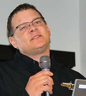
Watershed Project. Keynote speaker Terry Aukes (NRCS photo, right), of Hills in far southwestern
Minnesota, described the benefits and challenges of using cover crops to reduce
erosion and build soil organic matter.
The clear message was that conventional
crop production must change to include cover crops and reduced or no tillage. A
one percent increase in soil organic matter increases water-holding capacity by
19,000 gallons per acre, Aukes says. A farmer and co-op manager, Aukes concluded
with a quote from President Roosevelt in the 1930s: "The nation that destroys
its soil destroys itself." Among the breakout sessions, Kandiyohi County farmer
Charles Cunningham described his success with no-till since the late 1990s.
Other sessions included assessing soil health, soil biology and grazing. For
more information about the event, contact Melanie Dickman, district
conservationist, 320-235-3906, ext. 3.
Back to top
|
|