|
August 2014
The Basin Alliance for the Lower Mississippi in Minnesota (BALMM) will meet Wednesday, Aug. 20, from 9 a.m. to noon at the People’s Energy Cooperative, 1775 Lake Shady Avenue South, Oronoco, MN 55960. NOTE LOCATION CHANGE!
Agenda as follows:
-
9 a.m.: “Using Zonation, a Value-Based Model, to Prioritize Areas for Watershed Management” – Paul Radomski, research scientist, Minnesota DNR, Brainerd
-
10:15 a.m.: Break
-
10:45 a.m.: “Zonation Experience in the Pine River WRAPS” – Scott Lucas, project manager, MPCA, Brainerd Office
-
11:30 a.m.: “Indexing Historic DNR Fisheries Documents to be Searchable through GIS” – Mason Johnson, student worker, MPCA Rochester Office
-
Noon: Adjourn
As threats to Minnesota’s watersheds continue to mount, it is becoming increasingly important to identify and conserve high-priority areas to produce multiple benefits. One of the most common approaches for conservation prioritization is value-based models. Value-based models use a compilation of individual criteria of valuable landscape features (heterogeneous content) and aggregated criteria (context and connections) with an objective function to prioritize places within the landscape for conservation.
The Minnesota Dept. of Natural Resources used a value-based model prioritization approach that is based on fundamental conservation principles, and includes biology, hydrology, water quality, geomorphology, and connectivity components to identify where in the watershed specific good management practices should be applied. Feature-specific weights used in these models should reflect social valuation. At the Aug. 20 BALMM meeting, DNR research scientist Paul Radomski, of Brainerd, will present examples of value-based model priorities with feature-specific weights set using surveys.
 The Pine River watershed, just north of Brainerd, began its watershed approach process in 2012. MPCA project manager Scott Lucas decided to use zonation to prioritize Watershed Restoration and Protection Strategies (WRAPS). At the Aug. 20 BALMM meeting, Scott will talk through how this decision was made and the steps involved, as well as show maps that DNR research scientist Paul Radomski created during the process (see story above). Scott will also discuss the next steps for incorporating the zonation information into the WRAPS table and document.
|
MPCA student worker Mason Johnson has spent the summer scanning DNR fisheries files and making them readily available as PDFs. The files include stream assessments, stream management plans, field data sheets, and fish kill reports. At the Aug. 20 meeting, Mason will explain how the files are being indexed so that anyone may search words and/or titles within the documents. These files are also being incorporated into a GIS format, which links the documents to a shapefile of a stream.
 The Minnesota Board of Water and Soil Resources (BWSR) recently chose the Root River watershed as one of five watersheds for the One Watershed, One Plan pilot program. Funded by the Clean Water Legacy Amendment, the goal is to address water quality on a watershed basis. BWSR’s vision aims to align planning on major watershed boundaries with prioritized, targeted, and measurable watershed plans that will be developed and implemented locally.
Pilot plans will build on existing efforts, using current local water plans, state and local knowledge and a systematic, science-based approach to watershed management. The resulting plans will address the largest threats that provide the greatest environmental benefits to each watershed. The pilot program will involve a broad range of stakeholders, including local governments, state agencies, and community members as true partners in the planning process.
The Root River watershed includes parts of Dodge, Fillmore, Houston, Mower, Olmsted and Winona counties. The other pilot areas are Lake Superior North, North Fork Crow River, Red Lake River and Yellow Medicine River.
The One Watershed, One Plan program is grounded in 2011 recommendations from the Minnesota Local Government Water Roundtable, which said that local governments charged with water management responsibility should organize and develop implementation plans on a watershed scale. In 2012, the Minnesota Legislature gave BWSR the authority to work with local governments to develop and implement this comprehensive watershed management plan approach.
|
 The Legislative-Citizen Commission on Minnesota Resources recently selected 65 projects totaling $45.8 million to recommend to the 2015 Minnesota Legislature for funding from the Environment and Natural Resources Trust Fund (funded by the Minnesota Lottery and investment income). The recommendations are the result of the commission’s 2015 Request for Proposal (RFP) process, in which 152 proposals totaling $126.3 million were received and considered through a competitive, multi-stage evaluation process.
One of the recommended projects is $300,000 to the Zumbro Watershed Partnership to build eight recreational sites throughout the watershed to increase awareness of the river as a resource and motivate residents to adopt practices that help water quality. Each site will include a demonstration such as rain gardens, bank stabilizations, native plantings and interpretive kiosks as well as recreational features such as trails, canoe launches, picnic areas and fishing piers.
“The Zumbro River Watershed in southeastern Minnesota is an underutilized and overlooked recreational asset. It is a unique, diverse, and beautiful landscape of great environmental sensitivity,” reads the project proposal. "The Zumbro Watershed is 98 percent privately owned, which imposes some limits on the accessibility to the river. This has isolated the river from the residents and potential recreational users. A culture of water stewardship is needed where people have a connection with their river resource, appreciate it, and are willing to implement effective water protection practices that will help reduce and prevent future pollution and flooding across the watershed.”
Visit the commission’s website for a complete list of recommendations and other information.
|
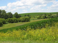
 Many streams flowing to Lake Pepin in southeast Minnesota offer high water quality and need protection, while a handful of trout streams need reductions in bacteria levels, according to a study by local partners and the MPCA.
The study will be open for public review and comment Aug. 11-Sept. 10. The agency and partners invite the public to an open house about the study on Tuesday, Aug. 26, from 4:30-6:30 p.m. at the Frontenac Sportsman Club, 30301 Territorial Road, in Lake City.
Called a Watershed Restoration and Protection Strategy, the study summarizes the health of a watershed. It also includes a report on Total Maximum Daily Loads, which are the maximum amounts of pollutants that streams can receive and still meet water quality standards.
This study focuses on the Mississippi River-Lake Pepin watershed from Red Wing to Lake City. This area encompasses 205,747 acres that drain several small coldwater streams in southeast Minnesota. (This study excludes Lake Pepin, which is the focus of a separate project.) The land is diverse with forests, bluff lands and cropland. Many streams here are popular for trout fishing.
For the most part, the streams are in good condition, supporting a healthy community of fish and macroinvertebrates. Macroinvertebrates are creatures without backbones, such as insects, snails and small clams, and are commonly called bugs. By examining a stream’s biological health, scientists can gauge the health of water resources. The healthier the water, the more diverse the fish and bug populations.
The study did identify a few concerns. The levels of bacteria in the following trout streams violate the state standard – Hay, Bullard, Gilbert, Miller and Wells creeks. The bacteria come from manure applied to cropland, rain and snowmelt runoff, and failing sewer systems.
Another concern is the level of nitrogen in some waters. Nitrogen can make water harmful for humans and aquatic life. While none of the trout streams violates the standard of 10 parts per million (ppm) of nitrate, concentrations range from 2-8 ppm. Extensive research in Minnesota and other states has found that human impacts are the main reason for higher nitrogen levels in lakes and streams. In this watershed, manure and fertilizer leaching from cropland are likely the main sources of nitrogen in streams. One study of southeast Minnesota trout streams found that the higher the percentage of row crops in the surrounding watershed, the higher the nitrogen concentrations.
While nutrient and sediment levels in these streams allow the waters to meet standards, the pollutants do impact downstream waters from Lake Pepin all the way to the Gulf of Mexico. Because of that impact, the study recommends several strategies to protect the streams in southeast Minnesota and downstream waters.
The study report summarizes work in the watershed dating back several years, including intensive water monitoring, sampling fish and bugs at 21 sites, and identifying conditions stressing the health of streams. It recommends the following:
- Managing fertilizer and manure applications to reduce impacts to waters;
- Expanding cover crops to help keep soil in place and enhance soil health;
- Holding back runoff to prevent flooding and erosion while letting pollutants settle out;
- Improving habitat;
- Restoring streams and their banks;
- Upgrading or replacing sewer systems;
- Complying with the Goodhue County mining ordinance that prohibits the use of certain additives for processing silica sand and requires setbacks from streams and other resources; and
- Continued monitoring to detect changes in pollutant levels and watershed conditions.
Local partners played a key role in the watershed study and will play a leading role in protecting the waters: Goodhue and Wabasha counties and their Soil and Water Conservation Districts; cities of Red Wing and Lake City; and Wells Creek Watershed Partnership.
For more information on the study or to submit written comments, contact Just Watkins, MPCA project manager, at justin.watkins@state.mn.us or 507-206-2621. The study is available on the Mississippi River – Lake Pepin project webpage.
|
Helping decision makers prioritize where to restore and protect wetlands is the purpose of a new online tool. The tool helps maximize water quality benefits and funding by:
- Predicting likely locations of restorable wetlands with a statewide restorable wetland inventory.
- Locating highly stressed areas most in need of water quality or habitat improvement.
- Prioritizing areas that have the potential to be, or currently are, high functioning sustainable wetlands.
- Identifying areas with the greatest benefits in the form of water quality and habitat.
- Refining prioritizations with aerial imagery and available environmental data.
Called the Restorable Wetland Prioritization Tool, it builds on and incorporates previous targeting approaches including the Environmental Benefits Index (EBI) and Stream Power Index (SPI) to produce three primary decision layers:
- Environmental STRESS;
- Expected BENEFITS; and
- Expected restoration success or VIABILITY layer.
 The Restorable Wetland Prioritization Tool allows users to adjust the weight of the three decision layers to select the best regional restoration locations to meet watershed challenges and goals. Each primary decision layer can be focused on water quality nutrient reduction, either phosphorus or nitrogen, or habitat emphasis. All data layers are offered as statewide coverage, including the restorable wetland inventory layer as well as many supporting physical or landscape information layers.
Most users will be able to complete their strategic wetland restoration project inquiries entirely within the online tool application. However, several of the derived decision layers, including unique blends of data layers, can be exported as raster image files which can then be added to standard desktop GIS projects.
Please note that full tool functionality is available using Firefox, Safari or Google Chrome internet browsers. Internet Explorer does not fully support the tool functionality.
The Natural Resources Research Institute (NRRI) at the University of Minnesota-Duluth developed this tool and continues to host it online at www.mnwetlandrestore.org. Funding support to develop this tool was possible through the Clean Water Legacy Amendment through a contract between the MPCA and NRRI. The NRRI's mission is to foster the economic development of Minnesota's natural resources in an environmentally sound manner to promote private sector employment.
For more information contact Mark Gernes of the MPCA south biological monitoring unit at mark.gernes@state.mn.us or 651 757-2387.
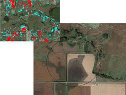
The image above is from an example of using the tool to identify areas for expanding a wetland in Sibley County. By using several layers, tool functions, and aerial imagery data, a user can identify high priority restoration areas as indicated by the red color.
|
 The Minnesota Dept. of Natural Resources is now accepting applications for the Conservation Partners Legacy (CPL) Grant Program. This program funds conservation projects that restore, enhance, or protect forests, wetlands, prairies, or habitat for fish, game, and wildlife. Grant requests may range from $5,000 to $400,000 with a maximum total project cost of $575,000. Nonprofit organizations and government entities are eligible to apply, and a 10-percent match of non-state funds is required. $8 million has been appropriated for Fiscal Year 2015. Funding for this grant program comes from the Outdoor Heritage Fund.
The application system for the Traditional CPL grant cycle is now open and $3.3 million is available for funding. Apply by Sept. 19.
$1 million is available for the Expedited Conservation Projects (ECP) grant cycle. ECP funds up to $50,000 for eligible activities on public lands or waters open to all seasons of hunting and fishing. The ECP application is open continuously through May 13, 2015, or until all funds are awarded. Apply by Sept.17 for the first round of ECP funding.
For more information, email lscplgrants.dnr@state.mn.us.
|
 The Minnesota Pollution Control Agency (MPCA) Citizens Board recently adopted amendments to water quality standards addressing eutrophication of rivers, streams, Mississippi River navigation pools and Lake Pepin. The amendments also replace the turbidity standard with a Total Suspended Solids standard.
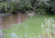
River Eutrophication. Excess nutrients and the resulting water quality in surface waters is a high priority problem for Minnesota and the U.S. Environmental Protection Agency (EPA). Too much phosphorus can lead to too much algae or eutrophication, which results in a green and slimy condition that is harmful for fish and other aquatic life. The EPA directed states to develop numeric water quality standards by 2003 to address this widespread water quality problem. Minnesota adopted eutrophication standards for lakes and reservoirs in 2008. This rulemaking proposes the same type of standards for rivers, streams, Mississippi River navigation pools, and Lake Pepin. The eutrophication standards set numeric levels for phosphorus and also for “response variables” of chlorophyll-a, dissolved oxygen flux, and five-day biochemical oxygen demand. A polluted condition exists when the phosphorus value and any one of the response variables are exceeded. In recognition of ecoregion differences, the proposed numeric standards are specific to River Nutrient Regions and certain reach-specific water bodies (Mississippi River navigation pools and Lake Pepin).
Total Suspended Solids. Minnesota water quality standards include statewide turbidity standards to protect aquatic life from the effects of sediment in the water column. Cloudy water makes it difficult for fish to clear their gills, find food and spawn. However, the previous approach to controlling suspended sediments in streams was limited by a lack of regional and seasonal specificity. This approach was based on a unit of measurement (nephelometric turbidity units) inconsistent with the current process for setting wastewater effluent limits and completing pollution reduction studies known as Total Maximum Daily Load Studies or TMDLs. The amendments replace the turbidity parameter with Total Suspended Solids, provide a regional basis for the numeric standards, and add a seasonal component to the standard, all of which provide a more accurate approach for protecting aquatic life.
A draft of the amendments was released in June 2013, followed by a public comment period from November 2013 to January 2014, including a public hearing held Jan. 8, 2014. Seventeen parties commented on the amendments. See their comments, the MPCA responses and more details in the board packet online. The MPCA Citizen’s Board adopted the standards at its June 24, 2014 meeting.
Following that meeting, the Minnesota Environmental Science and Economic Review Board petitioned the MPCA Citizens Board for a stay and reconsideration of the standards. At its July 22 meeting, the board heard from several parties about the petition before voting to deny the stay. A webcast of the meeting, along with the board packet, is available on the agency website.
More information is also available in the story on “Fighting the green slime: Preventing algae growth in river and streams.”
|
If your organization is interested in submitting proposals for MPCA surface water monitoring grants later this year, be sure to register now with SWIFT. All of the required materials for the Request for Proposal (RFP) process must be submitted through the SWIFT e-supplier portal for the 2015 Surface Water Assessment Grants (SWAG) and Watershed Pollutant Load Monitoring Network (WPLMN) Sampling Grants .
In order to view 2015 Request for Proposal (RFP) materials and apply for grant funds, proposers are required to have a SWIFT Vendor ID and Supplier Portal Account. Detailed registration directions are available on the SWIFT e-supplier portal. Potential proposers should be aware that it can take several days to receive a required Vendor ID from SWIFT and are encouraged to register now. For additional information regarding this application and process, please see this SWIFT message. If you need technical assistance for the SWIFT e-supplier portal, please contact the SWIFT helpdesk line: 651-201-8100, option 1.
All SWAG and WPLMN proposals must be electronically submitted through the SWIFT e-supplier portal. Proposals received after the established deadlines will not be considered. Additionally, grant recipients must use SWIFT to review and approve, through electronic signature, their final contract and work plan. The authorized representative within each organization that is awarded a grant must obtain a SWIFT user ID to perform the electronic signature.
The MPCA is responsible for carrying out and overseeing the monitoring of Minnesota’s lakes and streams using Clean Water Legacy funds. The SWAG and WPLMN grants channel these funds to local organizations to assist with these activities. Additional information for both programs can be found at the SWAG webpage and the WPLMN webpage.
“As crews clear sandbars, backed-up barges may sail down Mississippi by weekend” in the StarTribune
“University of Minnesota scientists install sound system to deter carp in Mississippi River” in the StarTribune
“National Trout Center: advocating for southeast Minnesota's fragile stream trout” in the StarTribune
“Frac sand shipping changes at Winona harbor on hold after group calls for review” in the Winona Daily News
“Mayflies, another sign of Mississippi rebirth” on the MPCA website
“New law to get more mercury out of the waste stream takes effect” on the MPCA website
 The Eco Experience at the Minnesota State Fair Aug. 21-Sept. 1 will feature the world’s largest wad of paper to highlight the need to recycle more paper. Other exhibits will focus on Minnesota’s changing climate, garden pollinators, green building products, and much more.
A partnership between the Minnesota State Fair, the MPCA, and more than 120 organizations and businesses from across the state, the Eco Experience has become the second most popular exhibit at the fair. It won the 2013 People's Choice award for "Best Attraction.” The Eco Experience is in the Progress Center building at the corners of Randall and Cosgrove.
|
|