
The Lessard-Sams Outdoor Council received 46 proposals totaling more than $221 million in response to its call for funding requests, which were due June 12. The requests are more than double the $100 million expected in available funding for projects that protect, restore and enhance wetlands, prairies, forests, and habitat.
At their Aug. 5 council meeting, members will decide which proposals to invite for presentations. For a complete list of proposals, visit the council website.
The requests range from $40,000 for the Middle Fork Crow River Watershed District to remove sediment from Indian Beach Harbor, up to $18.4 million for Pheasants Forever to accelerate the protection of 2,250 acres of prairie grassland, wetland, and other wildlife habitat as State Wildlife Management Areas open to public hunting in several counties.
The council makes annual recommendations to the Minnesota Legislature on appropriations from the Outdoor Heritage Council, which is funded by the Clean Water, Land and Legacy Amendment.
|
The Minnesota Dept. of Natural Resources (DNR) will open its Conservation Partners Legacy grant program Aug. 1. This program funds conservation projects that restore, enhance, or protect forests, wetlands, prairies, and habitat for fish, game, and wildlife in Minnesota. The DNR manages this program to provide competitive matching grants from $5,000 to $400,000 to local, regional, state, and national nonprofit organizations, including government entities.
The application system for the Traditional and Metro Grant Cycles will open Aug. 1 and will close Sept. 19.
The Expedited Conservation Projects (ECP) Grant Cycle will also open Aug. 1 and will be open continuously through May 13, 2015 or until all funds have been awarded.
Funding for this grant program is from the Outdoor Heritage Fund, created by the Legacy Amendment.
 A new report by the MPCA and the Lower Mississippi River Watershed Management Organization recommends restoring or protecting five water bodies in northern Dakota County and southern Ramsey County. The draft Watershed Restoration and Protection Strategy (WRAPS)/Total Maximum Daily Load (TMDL) Report is available for public review and comment through July 16.
The five lakes included in this study are:
- Thompson Lake in West St. Paul;
- Pickerel Lake in Lilydale and St. Paul;
- Rogers Lake and Lake Augusta in Mendota Heights; and
- Sunfish Lake in the city of Sunfish Lake.
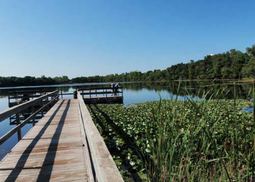
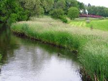
Of the five lakes studied, only Rogers Lake, in photo above, is currently meeting state water quality standards for nutrient concentrations. The other four lakes exceed their nutrient concentrations, and therefore require a reduction in phosphorus pollution.
To meet the water quality standard, excess phosphorus will need to be reduced by 22 percent for Thompson Lake, 64 percent for Lake Augusta and 33 percent for Sunfish Lake. In urban areas, excess phosphorus usually comes from organic material such as leaves and grass clippings, fertilizers and sediments often transported by stormwater. Phosphorus can also be released from sediments within the lake, contributing to an "internal loading" of phosphorus. Flood waters from the Mississippi River and bluff and ravine erosion also contribute phosphorus to Pickerel Lake.
Implementation strategies to reduce nutrients and additional water quality monitoring are recommended for all the lakes. "A variety of watershed and in-lake treatment strategies are being considered," says Barb Peichel with the MPCA.
Many groups have participated in the development of restoration and protection strategies, including the Lower Mississippi River Watershed Management Organization, member cities, Dakota County Soil and Water Conservation District, St. Paul and Dakota County Parks and Recreation, local residents, and other state and local organizations.
Peichel said the report is a tool which local water resource managers can use to identify and prioritize water quality improvement projects for the lakes.
Comments on the report should be submitted in writing by 4:30 p.m. on July 16 to Barb Peichel, 520 Lafayette Road N., St. Paul, MN 55155-4194, or barbara.peichel@state.mn.us. Peichel is available to answer questions by phone at 651-757-2646.
Written comments must include a statement of your interest in the report; a statement of the action you wish the MPCA to take, including specific references to sections of the draft report you believe should be changed; and specific reasons for your position.
The WRAPS/TMDL report identifies how much of a particular pollutant, such as phosphorus, water bodies in the area can receive and still meet water quality standards. After the public comment period, the draft WRAPS/TMDL report will need to receive final approval from the federal Environmental Protection Agency under the Clean Water Act.
|
As part of its review of water quality standards every three years, the MPCA recently set priorities for working on water quality standards.
The agency considered comments from the public, the availability of new science, the needs of MPCA programs, and federal mandates to develop the following list of priorities for the next three years:
Priority 1: Chloride, nitrate, ammonia, standards for industrial use and for wildlife and agricultural uses, and sulfate.
Priority 2: Standards for drinking water use, standards for human health, copper and bacteria.
Priority 3: Cadmium, outstanding resource value waters, and limited resource value waters.
The priorities list was presented to the MPCA Citizens Board on May 20, 2014, and is available with more information on the MPCA website .
The Triennial Standards Review is a requirement under the federal Clean Water Act that states review their water quality standards every three years and amend and update them if necessary. The purpose of the review is to ensure an opportunity for the public to comment upon the need for revisions to state standards.
 Showing how land use directly affects water quality just got easier with a new feature called “How’s the Water?” By clicking through maps, graphics and concise information, browsers can easily see the challenges facing Minnesota waters. They can also access the science and data – in layperson’s terms – behind the issues.
For example, clicking on “lakes” leads to a page explaining the threats of runoff, erosion and sediment, along with road salt and invasive species:
“Runoff from agricultural land and lakeshore development raises the amount of phosphorus in Minnesota lakes, which in turn causes algae to grow. Algae-covered lakes are less attractive for fishing and swimming — highly valued pastimes in Minnesota and uses that are protected under the federal Clean Water Act. In addition, phosphorus can fuel toxic blue-green algal blooms, which are harmful to people and pets.”
Other information on the page explains how road salt can contaminate lakes and streams, and how invasive species are hurting Minnesota waters.
The MPCA developed the “How’s the Water” feature to offer a snapshot of water quality across the state in four areas: lakes, rivers and streams, wetlands, and groundwater. The MPCA gathers and analyzes a huge amount of environmental data, but often that data is embedded in long and technical reports. “How’s the water?” offers a broad and accessible look at the threats to state waters, the current water quality in regions around the state, and the steps the MPCA and other groups are taking to restore and protect our water resources.
Browsers can also access details about specific water bodies, including water quality data, MPCA projects in the area, maps of land use and water monitoring stations, watershed overviews, recent reports, agency contacts and fish consumption advisories. They’ll also learn how they can help waters across the state, a difficult and long-term effort that must happen at all levels, starting with individual farm fields, homes and businesses.
|
 600. That’s the number of sites the MPCA biological water monitoring staff planned for this summer. 96. That’s the number of sites monitored so far - it should be closer to 250. The extreme rain events in June have hampered the MPCA’s water quality monitoring efforts across the state, but hit particularly hard is southern Minnesota where many cities have severe flooding. (Photo at right shows a cattle bridge damaged by high water in the Zumbro River watershed .)
Dan Helwig, MPCA surface water monitoring supervisor, believes the agency’s monitoring objectives may be hard to meet this year. "Normally, we can deal with high water by moving sampling operations to watersheds with less rain. However, the high amounts of rain state-wide have limited the ability of the crews to adjust and move because many places are experiencing high water levels." Protocol dictates the MPCA sample when conditions are near the average flow because sampling during drought or flooding conditions can give skewed results.
High flow events can have negative impacts on stream biology because of increased pollutant loads, like nitrogen and phosphorus, as well as stream chemistry changes. These impacts can be both natural – such as low-dissolved oxygen in streams due to the influx of water from wetlands – and aggravated by poor land use practices – such as an increase in contaminants and sediment due to poor stream buffers.
What does this setback mean for the MPCA? Right now it means the monitoring crews in the hardest hit parts of the state have to wait. According to Helwig, "At this point, even if we can get our water levels back to average, we may not be able to catch up. And, if there are more delays, there’s a good chance we will have impacts across our entire water program."
The MPCA works on a watershed approach, which is a 10 year monitoring cycle schedule. Each of the state’s 81 watersheds is monitored sometime in that 10 year timeframe and the monitoring results set the foundation for future work within each watershed. If the monitoring schedule is disrupted, other work that depends on that data, like waterbody assessments and restoration and protection plans, will also be affected.
See more information on the MPCA’s water monitoring strategy webpage.
|
The St. Louis River is one step closer to becoming healthier than it has been in a generation. And today’s river enthusiasts are invited to comment on the plan designed to achieve that goal.
The MPCA, Wisconsin Department of Natural Resources (WDNR), and their partners have developed a plan to remove the first of nine impairments to the river’s health that have kept it from being suitable for habitat and recreational uses it should support. The draft plan to remove the aesthetic impairment is being offered for public comment through July 17.
The other eight beneficial use impairments are: restricted fish consumption, threats to fish and wildlife populations, loss of fish and wildlife habitat, incidences of fish tumors and deformities, lack of diversity among bottom-dwelling organisms, restrictions on dredging activities, decreased water quality due to high nutrient and sediment levels and high levels of E. coli and fecal coliform bacteria that, when elevated, may generate advisories limiting beach water contact for swimmers and boaters.
This effort is the latest in 30 years of significant environmental improvements on the St. Louis River. Among the most significant effort benefitting the river’s aesthetic quality are: improved municipal wastewater treatment facilities and significant reductions in sewage overflows, upgraded stormwater infrastructure and polluted sites’ cleanups.
Written comments on the draft removal plan should be submitted by 4:30 p.m. on July 17, 2014 to Matt Steiger, WDNR, 1701 N. 4th St., Superior, WI 54880 or be faxed to Steiger at 715-392-7993. Related questions should be directed to Steiger at 715-395-6904.
 How healthy are Minnesota’s rivers and streams? How do our land use choices affect water quality and aquatic life? Do conditions vary in different parts of the state? These are some of the questions the MPCA is working toward answering in its newly published report, "The Condition of Rivers and Streams in Minnesota."
From 1995-2006, and again in 2010-11, the MPCA conducted two statewide water monitoring surveys, at randomly selected sites, to help researchers characterize the condition of rivers and streams throughout Minnesota. This is known as probabilistic surveying. Probabilistic surveys allow researchers to form conclusions about the condition of rivers and streams across the state with a known degree of certainty, much like a political poll. Information from the two surveys provides insight on current conditions and how different patterns of land use are associated with water quality and aquatic life. And now, for the first time, combined results of the surveys are available in the full condition of rivers and streams report on the MPCA website.
According to MPCA Biologist April Lueck, and co-author of the report, a third survey will begin in 2015, which, "combined with this report will help further identify short-term changes, build on our understanding of long-term trends, and aid in the development of watershed restoration and protection strategies throughout the state."
Among the many interesting findings in this report, some highlights include:
- The likelihood of finding healthy aquatic life in streams is dependent on both natural and human factors.
- Nearly 50 percent of Minnesota’s streams have been altered to promote drainage for agriculture and urban development.
- The state was divided into three regions based on soils, vegetation, topography, and land use. River and stream conditions generally range from very good in the northeast region to poor in the southwest region.
The report established baseline conditions for Minnesota’s rivers and streams, so that future surveys can track changes in overall river health.
|
 The MPCA recently advised dog owners to keep their pets away from algae-laden water following the death of a dog in Sherburne County.
Certain species of blue-green algae contain potent toxins that can be deadly to animals within hours. If pet owners see an area where water is thick, cloudy, or bright bluish-green, they should keep pets and children away. If a pet does enter algae-laden water, rinse it off with fresh water, and don’t allow the animal to lick its fur until it is clean.
Anyone who is concerned about a pet’s possible exposure to blue-green algae should consult a veterinarian immediately.
The MPCA encourages local partners to customize the full press release for use on their websites or in their newsletters. Photos and video of blue-green algae are also available on the MPCA website.
|
 The DNR will accept public comments through Aug. 15 on potential rules for the Mississippi River Corridor Critical Area (MRCCA). The DNR has developed a working draft of the rules following consultation with local governments and other interested parties, now available for review during this comment period.
Three public information meetings are scheduled:
- Wednesday, July 16, 6:30- 9 p.m., Greenhaven Golf Course (courtesy of City of Anoka), 2800 Greenhaven Road, Anoka, MN 55303
- Tuesday, July 22, 6:30- 9 p.m., Nova Classical Academy, 1455 Victoria Way W., St. Paul, MN 55102
- Thursday, July 24, 6:30- 9 p.m., Schaar's Bluff Gathering Center (Spring Lake Park Reserve), 8395 127th Street E, Hastings, MN 55033
The MRCCA is a unique land corridor along the Mississippi River within the seven-county metropolitan area. Land development in the 54,000-acre corridor is currently guided by state regulations that are implemented through local plans and zoning ordinances.
What do the proposed rules mean for local governments, homeowners, and businesses within the MRCCA? Local governments will eventually need to update their plans and ordinances for this area. Most homeowners and businesses should see little if any change in their status.
For more information visit the DNR website.
|
 Water resources in the Redeye River watershed range in condition from very high water quality to significantly impaired, according to a study recently posted by the MPCA. Based on intensive watershed monitoring, which began in 2011, results indicate that a handful of streams do not meet water quality standards for beneficial uses such as:
- Aquatic life;
- Drinking water; and
- Fish consumption.
The main concerns are excess sediment and high bacteria levels.
The Redeye River watershed covers nearly 900 square miles in the northern part of the Upper Mississippi River Basin in central Minnesota. The watershed includes all or parts of Becker, Otter Tail, Todd, and Wadena counties. The Redeye River begins at Wolf Lake and joins the Leaf River, before draining into the Crow Wing River near Staples. The river provides drinking water for households and industries, habitat for aquatic life, riparian corridors for wildlife and recreational opportunities like fishing, swimming, and canoeing. Nearly half the watershed’s land use is agricultural, 30 percent is forested, 15 percent wetlands, and about 4 percent developed communities and industries.
Primary resource concerns are wind and water soil erosion, surface and ground water management, and changing land use patterns. Increased development, wetland removal, and agriculture have all likely contributed to increased sediment and bacteria to surface waters, which leads to reduced populations of sensitive aquatic species. Biotic stressor identification is ongoing by MPCA staff and partners like the Wadena County SWCD and Otter Tail County coalition of lake associations.
|
The Minnesota Environmental Quality Board will discuss several water issues at its July 16 meeting, 1-4 p.m., in the MPCA Board Room, 520 Lafayette Road N., St. Paul:
- Overview of EQB statutory water responsibilities
- Water Governance Evaluation: 2014 update and future directions
- Planning for groundwater sustainability in the 21st century
- One Watershed One Plan
- Update on implementation of the Minnesota Agriculture Water Quality Certification Program
The Environmental Quality Board brings together the Governor’s Office (as chair), five citizens and the heads of nine state agencies that play a vital role in Minnesota’s environment and development. The board develops policy, creates long-range plans and reviews proposed projects that would significantly influence Minnesota’s environment.
MPCA Commissioner John Linc Stine will participate in a panel discussion at the University of Minnesota field day July 23 in Tracy, Minn. The field day, which will focus on drainage management, will run 9 a.m.-3 p.m. at the U of M Southwest Research and Outreach Center.
The panel discussion, which starts at 1 p.m. will center on achieving crop production environmental quality goals in the face of climate change. In addition to Commissioner Stine, other participants include Dave Frederickson, Minnesota Commissioner of Agriculture; Brian Hicks, farmer; Dr. Jerry Hatfield, USDA- ARS National Lab for Agriculture and the Environment; and Warren Formo, Minnesota Agricultural Water Resources Center.
There is no cost for the field day and lunch will be provided. For more information on tours and specific event times, visit the U of M research center website or call 507-752-7372.
The Minnesota Erosion Control Assoc. and Crow Wing County Soil and Water Conservation District will hold a Brainerd Shoreline and Watershed Practices Tour Tuesday Aug. 2, from 8 a.m. - 4:30 p.m., starting at Central Lakes Community College.
Tour highlights include:
- Shoreline restorations and native plantings;
- Infiltration swales;
- Rain gardens;
- Use of erosion and sediment control products; and
- Stream habitat restoration and buffers
Registration deadline is Aug. 3: Contact the MECA office at 320-685-5444 or meca@mnerosion.org.
|