|
The Minnesota Pollution Control Agency (MPCA) opened the funding round for the state Clean Water Partnership Program and the Clean Water Fund on Monday, May 5. The agency is accepting proposals through July 3 for grants and loans to facilitate projects that control nonpoint source pollution.
The MPCA anticipates that about $1.1 million of grant funds and about $7 million of loan funds will be available this year. At least $2 million of the loan funds will be set aside for Green Infrastructure Reserve. These proposals provide permanent stormwater treatment by preserving or restoring the site’s natural hydrologic processes through green infrastructure projects such as, but not limited to:
- Rain water harvesting and reuse;
- Rain gardens;
- Green roofs;
- Tree boxes;
- Porous pavement;
- Street and parking lot redesign; or
- Similar green infrastructure approaches.
Flood control may be a component, but not the primary objective of a project under this green infrastructure reserve.
The nonpoint source pollution project must be categorized either as protection or restoration:
- The proposer of a protection project will document that the water body(ies) being addressed are currently meeting state water quality standards for a particular pollutant or have not been assessed by the MPCA, but are otherwise known to be supporting beneficial uses.
- The proposer of a restoration project will document that the water body (ies) being addressed are impaired. These projects may or may not have a completed TMDL study or Watershed Restoration and Protection Strategy (WRAPS).
Priority for funding will be given to protection projects, Green Infrastructure Reserve loan projects, and loan projects of at least $100,000 that are requesting up to $10,000 for grant to administer the loan. Project proposals must provide measurable project outcomes.
The complete Request for Proposal (RFP), proposal form, and other information are available on the state SWIFT e-supplier portal. Prospective responders must have a SWIFT Vendor ID and Supplier Portal Account set up to apply. Please note that it can take up to four days to receive your vendor ID from SWIFT. See this SWIFT message for more information. If you need assistance registering in the Supplier Portal so you can bid on this solicitation, you may contact the Minnesota Department of Administration, Materials Management Division at 651-201-8100, option 1. Then follow the prompts to connect you to the correct contact person.
Proposals must be electronically received through the state SWIFT supplier portal by 4:30 p.m. on Thursday, July 3, 2014. Proposals received after the deadline will not be considered. This date and all other information in this notice are subject to change and only up to date information will be found in the SWIFT Vendor ID and Supplier Portal Account.
Questions may be e-mailed to Contracts.pca@state.mn.us , Attention: Tracey Josephson.
 The MPCA has awarded 14 Surface Water Assessment Grants (SWAG) for the 2014-15 monitoring seasons. Each year the MPCA seeks local assistance for water quality monitoring in accordance with its Intensive Watershed Monitoring Plan. With this plan, the MPCA has assigned a year to each of the 81 major watersheds in the state for sampling during a 10-year cycle.
For 2014-15, the MPCA is providing funds to assist with monitoring in the following watersheds: Clearwater, Des Moines River East Fork, Des Moines River Lower West Fork, West Des Moines River Headwaters, Lower Minnesota, Rainy River Headwaters, Red Lake, and Wild Rice.
Grants totaling $560,000 have been awarded to Carver County, Clearwater County Soil and Water Conservation District, Cook County Soil and Water Conservation District , Heron Lake Watershed District, Lake County Soil and Water Conservation District, Le Sueur County, Martin County Soil and Water Conservation District , Murray County, Red Lake Department of Natural Resources, Red Lake Watershed District ,Regents of the University of Minnesota Natural Resources Research Institute, Scott County Soil and Water Conservation District, Sibley County, and Vermilion Community College.
SWAGs provide local groups, American Indian Tribal governments, and colleges and universities with funds to gauge the health of lakes and streams. Additionally, grant dollars provide funding for training, citizen volunteer programs, equipment, and lab analysis of water samples.
The MPCA uses the data collected to determine if the lakes and streams support designated uses such as swimming and fishing. The MPCA works with partners and citizens on the local level to identify healthy lakes and streams that need protection. They also identify waters that fail to meet state standards and require restoration. The data collected help set priorities for the agency and funding sources like the Clean Water Land and Legacy Amendment.
The MPCA is responsible for carrying out and overseeing the monitoring of Minnesota’s lakes and streams using Clean Water Legacy funds. SWAGs channel these funds to local organizations to assist with these activities. Additional information for this program can be found at the MPCA’s SWAG webpage.
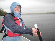
Photo above is Kerrie Berg with the Cook County Soil and Water Conservation District.
|
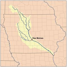 Starting in early May, MPCA crews will be conducting biological monitoring for fish and small aquatic life at nearly 100 sites in the Des Moines River basin in Minnesota. This includes portions of six counties: Nobles, Murray, Cottonwood, Jackson, Martin, Lyon and Pipestone.
The monitoring is designed to measure and evaluate the condition of rivers and streams by studying fish, aquatic invertebrates, and plant life as well as habitat, flow and water chemistry.
Examples of aquatic invertebrates include insect larvae, crayfish, snails, small clams, worms and leeches. Stream water chemistry is monitored to provide information about the quality of the water in which these fish and invertebrates live.
Local water management groups will also be sampling a smaller set of sites for water chemistry from May through September. The Department of Natural Resources (DNR) will be completing assessments of the geographical structure of stream and river beds.
Lake-monitoring crews will sample 20 lakes in the basin. The lake-monitoring teams will focus on water clarity, nutrient concentrations, and other water chemistry attributes to assess the lakes’ suitability for recreation.
The purpose of the monitoring is to develop a complete picture of the conditions of the water body types in the basin. There are certain expectations for what the biology and water chemistry should look like at a given sampling location. If samples do not meet those expectations, the sampling location could be considered impaired. If that happens, the MPCA would look more closely at what could be causing impairments and find ways to correct the problems.
The monitoring is part of a 10-year effort to assess the condition of rivers, streams and lakes in Minnesota. There are 81 major watersheds in Minnesota. Each watershed is comprised of a network of interconnected streams, lakes and wetlands.
Short videos showing the monitoring teams in action are available on the MPCA’s biological monitoring webpage. This work is being funded by the Clean Water Fund from the constitutional amendment passed by voters in 2008.
|
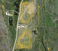
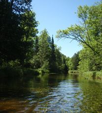 Located in northern Minnesota, the Big Fork River watershed is an outstanding recreational resource that drains more than 1 million acres -- providing plenty of fishing and canoeing opportunities for people seeking a northern Minnesota wilderness experience.
Lakes and streams in this watershed are good to very good despite a few impairments, according to a water monitoring and assessment report recently posted by the MPCA. High mercury levels limit the consumption of fish in some water bodies; many of the aquatic life impairments may be the result of watershed’s natural conditions. More work will be done to determine the causes of these impairments.
In addition to impairments listed above, the watershed’s additional challenges include:
- Fish tested for PCBs and/or PFOS had concentrations below the impairment threshold or detection limit.
- Eleven large streams or stream segments had low levels of bacteria and therefore were fully supporting aquatic recreation.
- Thirty-three of the 41 streams assessed supported aquatic life, six did not and two need more monitoring and assessment work.
This report is part of the state’s watershed approach, a holistic way of gauging the health of streams and lakes, and determining protection and restoration strategies to improve water quality. Local partners, including citizens, the Soil and Water Conservation Districts of Itasca and Koochiching Counties, the Itasca Community College, Itasca Water Legacy Partnership, Big Fork River Board and the state’s Department of Natural Resources and Board of Water and Soil Resources are working with the MPCA to implement conservation practices in the watershed.
The next steps for this process will determine prioritized strategies for watershed restoration and protection. Please look for opportunities to contribute to the planning efforts in the near future.
For more information, contact Mike Kennedy, Project Manager at 218-302-6629 or Jolen Simon, Program Coordinator, Koochiching SWCD, at 218-283-1180.
|
 Minnesota’s Adopt-a-River program, administered by the Dept. of Natural Resources (DNR), marks 25 years in 2014. Since 1989, Adopt-a-River volunteers have spent more than 18,000 hours cleaning 12,355 miles of shoreline. This has resulted in 6.3 million pounds of trash removed from Minnesota waters.
As the program’s website explains, the focus is on litter in stormwater: “To raise awareness about the problems of nonpoint-source pollution, Minnesota’s Adopt-a-River program stresses removal and prevention of rubbish accumulation by recruiting people to ‘adopt’ and maintain sections of shorelines. In this way, household hazardous waste, such as oil, aerosol cans, paint cans (still containing liquid paint), and batteries are cleaned up along with other trash. Although adopting a river often involves working with local parks, public works departments, soil and water conservation districts or county water plan coordinators, the DNR offers groups free cleanup bags and gloves, the ‘How-to’“ kit, and recognizes their efforts with a certificate signed by the Governor of Minnesota and the Commissioner of the DNR.”
Adopt a Highway also helping keep waters clean
Focusing on litter along Minnesota roads is the Dept. of Transportation (MnDOT) Adopt a Highway program. Through this program, community groups, churches, individuals, or businesses adopt a highway by picking up litter on both sides of a road for at least two years. Adopt a Highway also enables residents who are environmentally conscious to make a personal contribution to a cleaner environment. MnDOT provides volunteers with safety vests, trash bags and safety information. These volunteers save MnDOT $5 million every year.
Adopt a Highway provided these impressive statewide statistics for 2013:
- Number of groups participating - 4,885, an increase of 12 groups over 2012
- Number of volunteers - about 48,850, an increase of 120 volunteers over 2012
- Number of miles cleaned up - 10,415, an increase of 2.5 percent over 2012
- Number of pickups - 2,065, an increase of 21 percent over 2012
Keep America Beautiful
Research by Keep America Beautiful, a nonprofit group, shows that litter and littering have decreased in the past 40 years, but remains an important problem. Nationwide, the group estimates that there are 51.2 billion pieces of litter on our nation’s roadways. Improperly disposed cigarette butts are the most widespread litter problem, according to the research.
|
 Changes in hydrology and lack of habitat are the most common stressors to the biological communities (fish and bugs) in the Le Sueur River watershed, according to a report that the MPCA will soon post on its website. The report also cites high nutrient and turbidity levels as major stresses to aquatic life. These stressors are interacting with each other and degrade the fish and bugs living in the streams and rivers in the Le Sueur River watershed.
This watershed in south-central Minnesota is home to several small cities and numerous species of wildlife and fish. The watershed’s wealth of lakes and streams is a valuable resource for aquatic recreation such as fishing and paddling. The water’s health is essential to human quality of life and to sustaining aquatic life.
The watershed covers 710,832 acres within the Minnesota River Basin. Water quality is important to local citizens as well those downstream. Several studies have shown that the Le Sueur is a major contributor of sediment – soil particles and other matter – to the Minnesota River and eventually the Mississippi.
The stressors result from the significant changes over the past 150 years. Since European settlement in the 1860s the watershed has undergone major land changes, including the plowing of its native prairies, harvesting of its hardwood forests, draining of its wetlands and modifications to its natural stream courses. Agriculture accounts for the majority of land use activities within the watershed. Farmland is highly tiled for drainage purposes. Climate change is worsening the impact of these changes.
The MPCA and several partners identified the stressors in the watershed following an intensive water monitoring and assessment effort, which is part of the state’s watershed approach to restoring and protecting Minnesota waters. This approach is a holistic way of gauging the health of streams and lakes, and developing strategies to restore or protect their water quality.
The report includes recommended actions to improve water quality in the Le Sueur watershed, namely improvements to water and sediment retention.
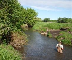
Photo above shows monitoring near an erosion site on the Little Le Sueur River.
|
 With detailed elevation data and mapping resources, a new mobile website called MnTOPO gives outdoor enthusiasts and scientists a chance to explore Minnesota’s landscape on desktop PCs, tablets, and smartphones, according to a DNR press release.
“This is a great way to use technology to illustrate the shape of earth’s surface and link people to the outdoors,” said Sean Vaughn, a DNR GIS hydrologist. “We can now give people a mobile way to cross Minnesota’s digital terrain to explore interesting places, understand water movement and navigate recreation lands.”
Under the Minnesota Elevation Mapping Project, high-accuracy elevation data was collected for the state using LiDAR technology. The MnTOPO website makes these data available so users can view topographic information as 3-D terrain and/or contours for all of Minnesota in a seamless panning environment.
“They can choose color aerial photography as a background base map, for example, and then drape contours over the imagery to expose terrain features hidden by vegetation in the imagery,” Vaughn said. “We created this with mobility in mind so that it can be easily accessed while in the field on just about any device using a modern web browser.”
MnTOPO has undergone extensive review since it was first released in late 2013 for testing.
It was developed with two primary audience applications in mind:
- Visual terrain exploration; and
- Digital terrain data download.
People who use the application will find the ability to peruse Minnesota’s 3-D topographic landscape exciting and beneficial, Vaughn said. Those interested in working directly with the data can download digital elevation models and LiDAR elevation data for their area of interest.
“We are only beginning to realize the value and usefulness that tools like this are providing to the public and scientists alike,” said Jason Moeckel, the inventory, monitoring and analysis section manager for the DNR Ecological and Water Resources Division. “The visual representation of accurate and modern topographic contours combined with aerial photography is extremely powerful for understanding how water moves across the landscape. We can apply that knowledge to help improve Minnesota’s water quality.”
MnTOPO’s mapping system shows landscape features and contours, but it is a general reference only and should not be used in place of a legal survey, or as a sole navigation aid.
This website was funded by the Clean Water Legacy Amendment.
|
After making changes based on public input, the MPCA recently submitted Minnesota's proposed 2014 Impaired Waters List to the U.S. Environmental Protection Agency (EPA) for approval.
The submittal follows an extensive public participation period that started in November 2013. The agency held five meetings across the state to discuss the listing process and the waterbodies impaired in the regions. During the formal comment period, the agency received public comments from 29 individuals or organizations, and responded to each one. Some comments warranted changes to the 2014 draft Impaired Waters List or the 2014 Guidance Manual (the document that explains how assessments are conducted). Contents of the public meetings, the public comments, the MPCA responses to comments, and the updated Guidance Manual were all sent to the EPA along with the 2014 proposed List for review.
This process of posting, revising, and submitting the Impaired Waters List occurs every two years.
The MPCA is continuing work to assess waters for the 10 mg/L sulfate standard in Minnesota Rules 7050.0224, subpart 2, that protects “water used for production of wild rice during periods when the rice may be susceptible to damage by high sulfate levels” as part of the 2014 Impaired Waters List. The MPCA plans to make the results of the wild rice sulfate standard assessments available in an addendum to this version of the 2014 Impaired Waters List.
For questions on the Impaired Waters List, contact Miranda Nichols of the MPCA at 651-757-2614.
The EPA has approved the following Total Maximum Daily Load (TMDL) reports:
- Sunrise River watershed TMDL project for multiple impairments related to nutrients, turbidity, low dissolved oxygen, pH and biology. This watershed in the St. Croix River Basin includes 12 lakes and 10 streams.
- Vadnais Lake Area watershed management organization TMDL and protection study for excess nutrients and bacteria. This TMDL identifies pollution reductions needed for five lakes and one stream to meet water quality standards. The watershed is located in the northeast metro area of Ramsey County and a small part of Anoka County.
- Redwood River TMDL project for fecal coliform in several sections of the river and the watershed, which is located in southwest Minnesota.
The TMDL reports are part of a nationwide effort under the federal Clean Water Act to identify and clean up pollution in streams, rivers and lakes. The TMDL is a scientific study that calculates the maximum amount of a pollutant a water body can receive, known as the “loading capacity,” without violating water quality standards.
State and local partners will present “Agricultural Drainage and the Future of Water Quality” on June 26, from 7:15 a.m.-5 p.m. at the Verizon Wireless Center in Mankato. This workshop will kick off at 7:15 a.m. that Thursday with breakfast. The indoor session will include panel discussions, speakers and breakout sessions until 2:30 p.m., followed by an optional tour of the Blue Earth County Ditch 57 project near Mapleton in the Le Sueur River watershed.
Topics include drainage water management, law change updates, and in-field techniques for water quality. Sponsoring the workshop are Blue Earth County, I + S Group, Minnesota Dept. of Agriculture and Minnesota Dept. of Natural Resources. To register, contact Kelli Renstrom at kelli.renstrom@is-grp.com or 507-387-6651.
The MPCA works with partners throughout the state to protect and restore water resources. The agency is proud to be a partner in two projects nominated for 2014 Environmental Initiative Awards. The awards will be presented May 22 at a formal dinner and ceremony in Minneapolis.
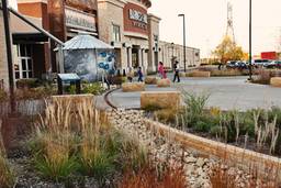 Shoppers’ special: State grants, local partners and innovative stormwater design
Parking lots can be major sources of lake pollutants in metro areas. An innovative partnership has turned one metro parking lot into a model treatment project. Funded by state grants, the Ramsey-Washington Metro Watershed District partnered with Maplewood Mall to outfit the mall’s 35-acre parking lot with extensive stormwater treatment features. Runoff now goes through 55 rain gardens, porous pavement crosswalks, and a sand filter before heading to downstream lakes, including Kohlman Lake impaired by nutrients. The project includes 175 trees in rain gardens with 200 more rooted in rock-filled trenches. All these features benefit water – and air – quality while providing ample safe parking and educational components.
One fun part of the design is a 5,700-gallon cistern that visitors can use to pump water through a simulated rainfall that triggers water wheels and chimes.
The project took five years of planning and construction. Before the project, 97 percent of the site’s 3 million gallons of annual runoff left the site untreated. Altogether, the treatment features are expected to now remove 60 percent of the parking lot’s original phosphorus load and more than 80 percent of the site’s sediment load.
Funding came from an MPCA, Minnesota Board of Water and Soil Resources and Minnesota Public Facilities Authority.
The project is a finalist for a 2014 Environmental Initiative Award in the Natural Resources category.
Plan takes flight for restoring St. Louis River Estuary
Coordinated by the MPCA, a plan to remediate the St. Louis River Area of Concern in the Duluth area will restore the river’s estuary by 2025 if successfully implemented. This plan addresses the headwaters of Lake Superior and the Great Lakes, including 130 years of accumulated environmental degradation and contamination in the St. Louis River Estuary. Nearly 100 partners, representing all levels of government, private groups and businesses, research and community groups, and the Fond du Lac Band, participated in developing the remedial plan.
The plan calls for removing contaminated sediment from the river and bay, as well as restoring 1,700 acres of fish and wildlife habitat.
This project is also a finalist for a 2014 Environmental Initiative Award in the Natural Resources category.
|
Dr. Michael Osterholm of the University of Minnesota will give the keynote address on the intersection of science and policy, using the recent triclosan legislative debate as a case study, at the Annual Mississippi River Forum Workshop Friday, May 30, 8:30 a.m.-12:30 p.m. at the Science Museum of Minnesota in St. Paul. Other presentations will include:
- "The Mystery of the Cottonwoods"
- "Sentinels for Clean Water: What Bald Eagles Tell Us about the Health of our Environment"
- "Minnesota Agricultural Water Quality Certification Program: An Update"
There is no admittance fee, but an RSVP to Lark Weller (651-293-8442) of the National Park Service is requested. This workshop is sponsored by the Mississippi River Fund and the McKnight Foundation.
|