|
The Legislative-Citizen Commission on Minnesota Resources recently narrowed the field of proposals for funding from 169 to 65. These 65 proposals are invited to present before the commission this month. The original 169 proposals totaled about $155 million in funding requests and these 65 total about $79 million. The commission will need to narrow the field more because only $34 million is expected to be available next year from the Environment and Natural Resources Trust Fund, which is funded by the Minnesota State Lottery and investment income.
The commission issued its request for proposals earlier this year. It will decide on which proposals to recommend to the 2013 Legislature for funding that becomes available July 1, 2013. For a complete list of projects being considered, visit the LCCMR website.
Funding proposals to the Lessard-Sams Outdoor Heritage Council are due June 29 at 4 p.m. The council has scheduled a session to help with proposals on June 13, at 1 p.m., in Room 51 of the State Office Building in St. Paul. The purpose of this session will be to answer questions on proposal preparation as well as review and answer questions about the on-line application system. It may be helpful for applicants to have started their proposals in the on-line system prior to the meeting to have a general familiarity. Please RSVP to Sandy at 651-297-7141 or sandy.smith@lsohc.leg.mn.
Council staff are also available to assist applicants. Anyone wanting assistance can contact staff at 651-297-7141 to set up an appointment.
The council issued its call for funding requests on April 5 and expects $92 million to be available for funding from the Clean Water, Land and Legacy Amendment. Through this Call for Funding Requests, the Council is seeking ideas on projects to recommend for funding to the 2013 Legislature for Fiscal Year 2014 (July 1, 2013-June 30, 2014). This request is open to all who want to apply.
 The MPCA has released a draft water quality report for the Lac qui Parle and Yellow Bank rivers, and is accepting comments on the report through June 27.
The report addresses water quality impairments from bacteria, turbidity, and low dissolved oxygen pollution in eleven sections of the rivers.
Sources of bacteria include failing septic systems, wastewater treatment plant bypasses and flushes, livestock manure from feedlots and land application, and stormwater from cities and commercial areas. Domestic pets and wildlife are also possible sources. Turbidity is caused by particles, such as sediment and algae, that are suspended in water, making the water appear cloudy or murky. Low dissolved oxygen results from bacteria consuming algae and other organic matter.
The Lac qui Parle-Yellow Bank watershed drains about 1,712 square miles in western Minnesota (976 square miles) and eastern South Dakota (736 square miles). The Lac qui Parle starts at Lake Hendricks in Lincoln County and flows north through Yellow Medicine and Lac qui Parle counties. The Yellow Bank River is located in the northern portion of Lac qui Parle County. More than 90 percent of the land in the watershed is used for agriculture, primarily for row crops such as corn and soybeans.
The Lac qui Parle-Yellow Bank TMDL draft report is available for review at the MPCA website. Comments on the report must be in writing and received by 4:30 p.m. on June 27. Send comments to Katherine Pekarek-Scott, MPCA, 504 Fairgrounds Rd., Suite 200, Marshall, MN, 56258 or by email to katherine.pekarek-scott@state.mn.us.
|
The U.S. Environmental Protection Agency recently approved the Total Maximum Daily Load (TMDL) reports for the Zumbro River watershed in southeast Minnesota and the North Fork Crow River, Rice Lake in central Minnesota.
The Zumbro watershed includes impaired reaches of the Zumbro River, Silver Creek, Bear Creek, Willow Creek, Cascade Creek, Kings Run, Dodge Center Creek and Milliken Creek. See the final report on the Zumbro TMDL project webpage. The Zumbro River watershed is located within the Lower Mississippi River Basin and includes parts of Olmsted, Dodge, Goodhue, Rice, Wabasha, and Steele Counties, near the City of Rochester.
Rice Lake is a 1,651 acre lake within the lower region of the North Fork Crow River Watershed District (NFCRWD). The watershed district encompasses about 350 square miles and includes 48 miles of the North Fork Crow River. Land use in the watershed is primarily agricultural. The lake accepts drainage from Pope, Stearns, and Kandiyohi Counties. Rice Lake is impaired by excess nutrients. See the final report on the North Fork Crow River, Rice Lake project webpage.
The MPCA will now work with local partners to develop an implementation plan to reduce pollutants in the impaired waters.
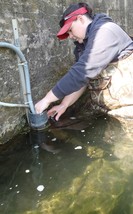 Jennifer Ender, a pollution control specialist with the MPCA, has her hand on the pulse of rivers in southeast Minnesota, including the Zumbro River and Whitewater River watersheds. She checks the health of several rivers and contributing streams twice a month. Ender is responsible for an incredible amount of data that will flow to several projects. By studying the data, the MPCA and partners identify healthy waters that need protection and problem areas that need restoration.
The MPCA recently featured Ender in a Minnesota Water Story. See the full story on the MPCA website.
|
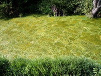 When the summer temperatures rise, conditions are ripe for Minnesota lakes to produce harmful algal blooms. The Minnesota Pollution Control Agency reminds people that a type of algae called “blue-green” algae can harm pets, livestock and even people.
Harmful algal blooms often smell unpleasant and can look like pea soup, green paint, or floating mats of scum. “You don’t have to be an expert to recognize an algae bloom that might be harmful,” MPCA lakes expert Steve Heiskary said. “If it looks bad and smells bad, don’t take a chance. Stay out, and keep children and pets away from the water until the bloom subsides.”
See the full press release on the MPCA website. Local partners are welcome to use this press release in their newsletters and post on their websites.
|
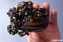 Invasive species are threatening Minnesota lakes and rivers. Aquatic invasive species such as zebra mussels, flowering rush, spiny waterflea and Eurasian watermilfoil are drawing attention across the nation and especially in Minnesota. These invasive species hurt fish populations and tourism, cause algae blooms and foul beaches, and wreak economic havoc by clogging boat motors, water supplies and drainage systems.
Anyone working in water quality, from volunteers to agency staff, can help spread the word about stopping the spread of invasive species. One new tool is a series of eleven 30-second public service announcements have been professionally produced to educate residents and visitors on easy steps to stop the spread of aquatic invasive species. RMB Environmental Laboratories and the Pelican River Watershed District led the productions, which were funded by the Central Region Sustainable Development Partnership, the Minnesota Dept of Natural Resources and a blend of lake coalitions, watershed districts, property owner associations, and foundations.
Please help get these videos out to the public. Consider asking local access TV stations to air them or local newspapers to highlight them, or include information about them in newsletters and listserves, or share them via web sites and Facebook. To see the videos, download, share, and learn more, go to the Natural Innovations webpage.
|
 Going to the beach in the Great Lake region? Now you can get real-time information on beach water quality advisories, weather and water conditions all on your mobile phone.
The Great Lakes Commission (GLC), in partnership with LimnoTech and the Great Lakes states, has developed a free smartphone application that provides convenient, public access to swim advisories and other environmental conditions information for more than 1,800 beaches in the Great Lakes region.
Funded by the Great Lakes Restoration Initiative, the myBeachCast application (app) retrieves locational and advisory data for Great Lakes and inland lake beaches in the eight Great Lakes states.
Data providers who are contributing to myBeachCast include the states of Illinois, Indiana, Michigan, Minnesota, New York, Ohio and Wisconsin; Pennsylvania’s Erie County Department of Health; BeachGuard (Windsor Solutions); NOAA; and GLOS.
|
The Minnesota River Board is hosting a Water Quality Professionals Assembly June 27 at the City Center Hotel in Mankato.
Topics will include:
- Status of the Minnesota River;
- Revisiting the Minnesota River Assessment Plan-20 years later;
- Biotic indices and their use in water management;
- Perspectives on the progress in the Minnesota River Basin;
- Status of the Farm Bill and the Future of Federally-Funded Conservation Programs;
- Launch of innovative conservation programs; and
- Agriculture and the future of conservation.
Speakers include Minnesota Rep. Jean Wagenius; Gene Merriam of the Freshwater Society; Don Baloun of NRCS; and Benjamin Lundeen of the MRAP Study.
For more information, contact Susan Carlin of the Minnesota River Board at 507-389-6279.
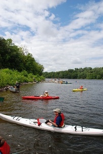 The Friends of the Mississippi River will holds its annual “Challenge,” a paddling event that raises funds and awareness for a healthier river, July 28-29.
This year, the Mississippi River Challenge will take paddlers on a new route, spending the first day on the Minnesota River and the second on the Mississippi River. On the first day, paddlers will head 17 miles downstream on the Minnesota River from Bloomington Ferry in the Minnesota Valley National Wildlife Refuge to Fort Snelling. After staying overnight at the Fort, paddlers will continue 22 miles on the Mississippi River from Fort Snelling to Grey Cloud Island.
Also new this year, the Mississippi River Challenge offers three route options – a half-day, a one-day, and a two-day paddle. With any of the three options, you will enjoy a beautiful stretch of river paddling as well as festivities and music by the Roe Family Singers at Historic Fort Snelling.
The event is seeking volunteers as well as paddlers. More information is available on the event website.
|
Waterfront is an email-bases bulletin featuring updates on impaired waters, watershed project funding and water restoration and protection activities underway throughout the state. Waterfront is published to share information with internal MPCA staff and external watershed partners.
The MPCA welcomes submissions from partners about funding opportunities, projects updates and upcoming events. Email submissions to catherine.rofshus@state.mn.us. Please note that the MPCA has switched to a new service, called GovDelivery, to deliver the Waterfront Bulletin. To ensure delivery of these messages, please add mpca@public.govdelivery.com to your address book or safe sender list.
Cathy Rofshus
Public Information Officer
MPCA-Rochester-Mankato
507-206-2608
|