|
Thank you for monitoring in 2022! We know there's so much out there competing for your time and attention. Work, kids, grand kids, hobbies, other volunteer gigs, travel - the list goes on and on. However, even through all of that, you took the time to launch your boat or clamber down the stream bank and monitor water clarity. Hopefully, this act gave you a few moments of quiet connection with your lake or stream. To view it for what it was at that day and at that particular moment. To gaze at the water and contemplate all that may be happening beneath the surface. To wonder for a brief moment, where that water has been and where it may be going. Water has a way of simultaneously clearing our minds and conjuring memories. It's a gift that I know we all value and you show how much you value it by continuing to participate in this program year after year.
We can't wait to share the results of your hard work with you over the coming months. We are compiling all data you submitted and analyzing it. We hope to have updated reports and new maps to share by March. In the meantime, know that we are so happy you choose to collect this valuable data and participate in the program!
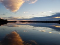
Photo credit - Kit Arnquist, lake volunteer
Back to top
|

When the University of Minnesota launched the Volunteer Water Monitoring Program in 1973, it would become the second oldest, and still active, volunteer water monitoring program in the nation (a similar program in Maine had them beat by only two years). This program, transferred to the Minnesota Pollution Control Agency in 1978, has been by all measures, a roaring success – empowering residents of the state and giving everyone a greater understanding of the health of our state’s waters.
Over these past 50 years, the Volunteer Water Monitoring Program has supported thousands of volunteers in collecting hundreds of thousands of data points on all manner of Minnesota waterbodies. From small ponds to a Great Lake. From babbling brooks to raging rivers. Encompassing rural farmland, highly developed urban areas, and all manner of space in between.
Time is a great equalizer, and the beauty of long-term data gathering initiatives like the MPCA’s Volunteer Water Monitoring Program is that all data are used and are considered useful. Old data are just as important as new data because both are needed to understand how conditions change over time. Some volunteers find a true calling with the program - monitoring for 20, 30 or even 40 years. For others, it’s more of a fleeting experience, with one or two years under their belt before life and commitments take them elsewhere. It’s important for people to realize that the same person doesn’t have to monitor a lake for twenty-five years to make a difference (although that is the gold standard!). What is important is that someone is doing it.
That is why we are so grateful to every volunteer that has joined the program and dedicated their time to monitoring their favorite lake or stream. 50 years is a huge milestone and we plan to take this golden opportunity to highlight our program’s amazing volunteers over the course of 2023. We quite literally could not do this without you. Thank you for making the past 50 years of the program so amazing. We look forward to another 50 more.
Back to top
|
By Megan Holthaus, MPCA Water Monitoring Lead
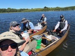
For MPCA field staff, the 2022 monitoring season was a busy one! They took part in the Environmental Protection Agency’s National Lake Assessment (NLA) Survey, which involved sampling an additional 110 lakes, while still conducting monitoring for all our other programs. You might recall from the May issue we planned to sample 150 lakes, but due to how packed the field season was, field staff will be completing the remaining 40 lakes this coming field season. Other programs we conducted monitoring for last summer include intensive watershed monitoring, statewide wild rice monitoring, long term chloride lake monitoring, total metals monitoring, and sentinel lake monitoring.
NLA took our staff all over the state this past summer, with sites being as far south as Worthington, and as far north as Warroad. We even completed a few portages through the Boundary Waters Canoe Area Wilderness. A large portion of lakes within the survey happened to only be accessible via private property, and a lot of property owners granted us permission to utilize their land – we couldn’t have done it without them!
When staff weren’t busy dodging angry swans, traversing through several feet of cattails, and lugging heavy equipment through the woods, they collected a lot of samples and field data. Samples collected include total phosphorus, chlorophyll-a, turbidity, zooplankton, phytoplankton, aquatic macroinvertebrates, algal toxins (microcystin and cylindrospermopsin), Enterococci (indicator of fecal contamination from animals or humans), pesticides, environmental DNA, and on a smaller subset of lakes, fish. Field measurements included water clarity, water temperature, dissolved oxygen, and an assessment of nearshore physical habitat. It will be some time until the 2022 results are available, however you can review the previous 2017 NLA data here if interested.
Back to top
|

Help us help you! All volunteers are encouraged to take our Volunteer Water Monitoring Program survey by this Friday, February 3rd. The program has created a short survey to evaluate processes (such as online data submittal) and your satisfaction with the program. Your voluntary participation in this survey will help us improve program operation and enrich your monitoring experience.
Take the survey here - it should take you less than 10 minutes to complete.
Thank you for your time and commitment to the program's advancement!
Back to top
|
By Melissa Maurer-Jones, Associate Professor, Dept. of Chemistry & Biochemistry, University of Minnesota - Duluth
Humans have been making changes to our natural environment for generations. But since the industrial revolution, we’ve been dumping, whether intentional or unintentional, person-made products into our natural systems. Lately, a lot of attention has been given to the plastic litter that we see when we’re enjoying a walk in the park or fishing on the lake. So many of you could already answer the question posed by the title of the piece with a resounding “yes.” Yes, you’ve seen plastic bags or fishing lines tangled in the shoreline shrubs. Yes, you’ve seen a swim floaty go across the lake on a windy day. But did you know we can’t always see the plastic pollution?
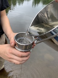
Microplastics are small plastic particles that we typically can’t see. In the past 5-10 years, researchers have been trying to understand how abundant microplastics are in our rivers, lakes, and oceans and they are being found in all types of natural places. Microplastics come from a variety of sources but generally come from the wear of plastic-made products, including from polyester textiles, plastic pipes, and single-use plastic products. Researchers also are interested in identifying different characteristics of microplastics, including size, morphology, and plastic type, because this can give us insight into how long the plastics have been in the environment and/or point to potential sources of the microplastics. One important goal through this counting is that if we understand what plastics are out there, we might better design remediation strategies to mitigate the potential risks of plastic pollution. There is still much work to be done to unravel relationships between microplastics in our lakes and important characteristics of those lakes, particularly in Minnesota where our lakes have a large range of inputs, geologies, sizes, and use-levels (e.x., urban vs recreational vs remote).
|
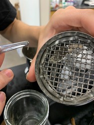
That’s where we’re looking for help and hoping to build a network of community scientists! Funded by University of Minnesota Institute on the Environment, myself along with a team of university professors and high school teachers are building microplastic sampling and analysis kits that will enable us to survey lakes across the state. Beyond engaging with curious community scientists, these kits are being designed with educational standards in place so high school science teachers can use them in their classrooms with opportunities to interface back with our universities. The team working on this effort includes 2 universities (UMD and UM-Twin Cities), 3 departments, and high school teachers serving a diverse group of Minnesotans in rural, suburban, and urban schools. We are on track to deploy these kits more widely come Fall 2023. Through this work, we strive to make an impact on promoting and maintaining Minnesota’s clean water.
If you have any questions regarding this microplastic monitoring initiative, feel free to contact me at maujones@d.umn.edu.
Back to top
|
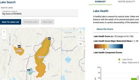
The Minnesota Department of Natural Resources has created a new online tool providing health assessments for thousands of Minnesota lakes. Called “WHAF for Lakes” (or “WHAFL”), the tool is part of the DNR’s Watershed Health Assessment Framework (https://www.dnr.state.mn.us/whaf/about/watershed-reports.html). “WHAF for Lakes will be valuable to anyone who wants to know more about a particular lake’s water quality and the health of the aquatic habitat and community in that lake,” Paul Radomski, DNR lake ecologist, said. “It can help guide decisions about lake protection and restoration.”
Users can compare a lake’s health measures to other nearby lakes. Along with graphics showing lakes’ relative water quality, biology, and hydrology, WHAF for Lakes includes information about basic lake characteristics and lake stewardship.
WHAF for Lakes can be reached directly from any web browser (https://arcgis.dnr.state.mn.us/ewr/whaflakes/), while exploring watershed health with the WHAF Map (https://arcgis.dnr.state.mn.us/ewr/whaf2/) or from the DNR’s popular LakeFinder webpage (https://www.dnr.state.mn.us/lakefind/index.html).
Back to top
|
Thank you to all of the Lake Ice Reporters who submitted ice in date(s) for their lake. We had over 160 MPCA volunteers report ice-in data on over 180 lakes across the state. These data are incredibly valuable in tracking lake ice duration, how it may be changing over time, and the effects those changes may have on lake ecology.
Ice in data shared with the MPCA by the first week in January have been uploaded to the MN State Climatology Office’s Lake Ice In Online Map. We hope to get data that's come in over the past few week into our system and uploaded to the map by early February. If you haven’t submitted your ice-in date yet, please send it to us in a quick email to ice.pca@state.mn.us.
If you've never submitted ice data before, please consider starting! It's quick and easy. Just send us an email (ice.pca@state.mn.us) each spring and fall with your name, lake name and the ice off or ice on date. It's that simple! Check out our website for more details.
Back to top
|

By John Weiss, 20 year stream monitor
New to southeast Minnesota in the mid-1970s, I discovered the bluff lands, beginning in the Whitewater Valley.
This land of rugged bluffs, small trout streams and the giant Mississippi River has been here all along and I never knew of it?
I was agog.
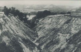
Then, as an outdoors writer, I began to learn more of the history of the Whitewater Valley. Erosion was that bad? A whole town was abandoned? Gullies were up to 50-feet deep?
I was aghast.
But yes, it’s true. I read reports and books, talked with experts and former residents of the valley, and have hiked, fished, hunted and canoed the valley that goes from a bit of Olmsted County into Winona Country and joins the Mississippi River in Wabasha County. This is what I’ve learned:
Before Europeans settlers arrived, the bluff lands of the southeast had much more prairie, kept burned by Native Americans and lightning.
The first European settlers who began coming in the 1850s, however, didn’t know how to farm bluff lands. They plowed up and down the hillsides, let cattle loose in woods or on hillsides. The result was utter ugliness.
Stories of erosion chaos from the late 1800s into the first several decades of this century are the stuff of legend today. Like the one gulley that was so deep a picture has three men in it or on its edge but it’s hard to even see them. Or the story of one family’s home that was a showpiece of the Whitewater Valley - ornate, beautiful. Then one year a gully began forming behind it. It got bigger and sand started coming next to the house. then against the house and finally into house. The only thing left is a spring bearing the family’s name.
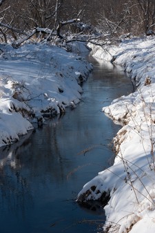
The land was like a tin roof and it took very little rain to push creeks or the river out of their banks. Because of that, Elba flooded about 30 times in one year as did Beaver, the little town that has to be abandoned because Beaver Creek would surge into the town with each rain; as it fell, more flood water would flood up from the Whitewater River.
|
The valley was healed by the state buying out thousands of acres and turning it into the WWWMA. Thousands of trees were planted but mostly, they gave the land time to heal itself. Now, it’s that oasis that is well known throughout the region and parts of three states.
But don’t think this was just a Whitewater problem. It was common throughout the Driftless area. In fact, it was worse in areas with more sandy soils. The first federal conservation districts were in Coon Valley, Wis., and the Stockton area of southeast Minnesota.
The problems from erosion from the past, however, are not gone. Colluvium - material that eroded and ended up at the base of slopes but not in the water - had been covered over by bio shields such as grass or trees. But with heavier rains of the past years, the shields are being wiped out and colluvium can get into rivers.
There are also mode heavy rains that send the river and streams out of their banks and often damage them. The DNR and Trout Unlimited are trying to fix stretches, a few each year, throughout the bluff lands, including in the Whitewater Valley.
We are not yet done with helping the Whitewater Valley heal.
If you want to read more, get “Historical Agriculture and Soil Erosion in the Upper Mississippi Valley Hill Country” By Stanley Trimble. It’s really good and the Whitewater Valley gets a lot of attention.
Photo #1 of Hick Gully provided by Whitewater State Park
Photo #2 of Beaver Creek today provided by John Weiss
Back to top
|
|
|