|
You can now view your 2019 Citizen Lake and Stream Monitoring Program data! To access your 2019 data, go to the Citizen Monitoring Program Individual Site Report website. From there you can navigate to your data in one of two ways:
1. Use the map tab to navigate to the monitoring site on your lake or stream. Click on the black triangle next to the lake ID or the black circle next to the stream ID. In the box that appears, click on "Citizen Monitoring Report" . Your report will open in a new tab.
2. Use the text tab to enter your monitoring site number (i.e. 01-0001-00-101 for lakes or S001-101 for streams) in the very bottom box titled "Citizen Monitoring Site or Lake ID number." A new page will open with the name of your lake or stream and the monitoring site number you entered. Click on the monitoring site number and your report will open in a new tab.
If you have any questions regarding your report, please feel free to contact us at clmp.pca@state.mn.us for the Citizen Lake Monitoring Program and csmp.pca@state.mn.us for the Citizen Stream Monitoring Program.
We greatly appreciate your patience in waiting for the release of these reports. Back to top
|

The 2020 water monitoring season is underway and we are asking that all MPCA citizen water monitors adhere to the guidelines in Executive Order 20-38, which include maintaining 6-foot social distancing, avoiding crowded areas and staying close to home for outdoor recreation.
As the monitoring season continues and if the situation changes, please use your best judgement on whether you feel safe to conduct lake or stream monitoring. If you’d prefer not to monitor in 2020, we fully support that decision and will keep you on the list as a monitor for 2021. Please remember that you represent the Citizen Lake and Stream Monitoring Program in your community. If you do monitor, please adhere to the guidelines laid out by Governor Walz.
Please don’t hesitate to contact us with any questions by emailing us at: csmp.pca@state.mn.us or clmp.pca@state.mn.us.
To learn more about how the State of Minnesota is responding to the COVID-19 crisis, visit COVID-19 Response / Office of Governor Tim Walz and Lt. Governor Peggy Flanagan. For the latest information on the COVID-19 outbreak in Minnesota, please visit the Minnesota Department of Health website. The MPCA also posts information about its response to COVID 19 on its website.
Back to top
|

Do algae blooms, zebra mussels, stormwater and agricultural runoff cause you worry? Have you ever wanted to talk with a resource manager, local decision maker or elected official about water quality in your community but don’t know how to go about it? The University of Minnesota Extension’s EmpowerU program can help!
EmpowerU has been helping volunteers and land owners learn critical skills to influence invasive species management for years, and now the CMP is teaming up with EmpowerU to offer a series focused on water resource management this fall.
We anticipate the training will be offered in November. It is a four week virtual course that takes approximately 8 hours total (approximately 1 hour/module, 2 modules/week for 4 weeks) to complete. It is self-paced with periodic instructor contact. The training culminates with one final synchronistic session at the end of the series. Traditionally this would be in-person, but this may be changed to a web-meeting. There is a $50 registration fee, which covers the cost of the instructor’s time and costs associated with the final synchronistic session.
At the end of this training you will:
- Understand the roles and levels of government and who to contact regarding water resource management.
- Learn to use skills such as influence, power, persuasion, framing, questioning and listening in interactions with decision makers.
- Know where to find reputable information on the status of water quality in your area.
- Have an engagement plan and experience practicing it in a safe, peer-learning environment.
- See yourself as a resource to decision maker on water quality management.
- View engagement with decision makers as a norm and encourage others to do it.
- Network with other people passionate to make a difference on water quality.
Most importantly, you will be able to apply what you have learned in this workshop to confidently share information with decision makers, give input on policies and plans, and be an active voice in water resource management.
More information will be provided this summer on when registration for the training will open.
"I appreciated the clear and organized nature of the course and how it helped me develop new skills in a step-by-step fashion. As a result of the process, I feel much more qualified to build and present a strong case for advocacy around environmental concerns. An added bonus was gaining a new network of other committed individuals and key contacts." - Dana, EmpowerU participant
Back to top
|
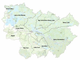
The Rainy-Lake of the Woods Basin is shared between Minnesota and Ontario, with a small portion in Manitoba, Canada. When broken down into its ten major watersheds, it becomes very obvious that water knows no boundaries and the watershed boundaries are what matter. However, the way in which data are collected, water is monitored and restoration plans are put in place all differ greatly between the two countries. With numerous watersheds contained within the Rainy-Lake of the Woods Basin, all at varying stages of Minnesota’s Watershed Restoration and Protection Strategy (WRAPS) or Ontario’s Broadscale Monitoring cycle, a story has been written on each one – check them out here to find out more about what’s happening in your watershed.
Back to top
|
Darby Nelson is an aquatic ecologist, biology professor emeritus at Anoka-Ramsey Community College, and an author committed to exploring, preserving, and celebrating Minnesota’s rivers and lakes. His first book, For Love of Lakes, was published in 2012. With an ecologist’s lens and a lifelong appreciation for wild and scenic places, Darby wanted to share his love for the Minnesota River with as many people as possible. He and his wife, Geri, decided to paddle the river all the way from its source near the Minnesota - South Dakota border to its confluence with the Mississippi in the Twin Cities. The resulting book, For Love of a River: The Minnesota, recounts their paddling adventure and addresses topics as diverse as geological history, early and modern agriculture, citizen advocacy, water-quality challenges and solutions, river-based recreation, dams and dam removal, prairie pothole lakes, the river’s rich diversity of plant and animal life, and the Dakota–US War. With so many of us staying home and finding extra time to read, we thought this would be an interesting book to share with you all! You can read more about Darby and find his books at: http://www.darbynelson.com/
Back to top
|
By Kimberly Kaiser, Minnesota Department of Agriculture Hydrologist
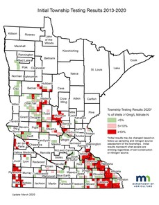
The Minnesota Department of Agriculture (MDA) determines current nitrate-nitrogen (nitrate) concentrations in private wells, on a township scale, through the Township Testing Program (TTP) which supports the Nitrogen Fertilizer Management Plan (NFMP). The MDA has identified townships throughout the state that are vulnerable to groundwater contamination and have significant row crop production. More than 90,000 private well owners have been offered nitrate testing in over 344 townships by 2019.
Each selected township is offered testing in two steps: the “initial” sampling and the “follow-up” sampling. In the initial sampling, all township homeowners using private wells are sent a nitrate test kit in the mail. If nitrate is detected in their initial sample, the homeowner is offered a well site visit by a trained hydrologist for a follow-up nitrate test and pesticide sample.
As of January 2020, 344 vulnerable townships from 50 counties participated in the TTP from 2013 to 2019. In the 344 townships initially tested, 143 (41%) had 10% or more of the wells over the Health Risk Limit (HRL) for nitrate. Overall, 9.1% of the 32,217 wells exceeded the 10 mg/L HRL for nitrate.
The MDA has sampled approximately 6,100 wells in 42 counties for nitrate and pesticides as part of the Private Well Pesticide Sampling (PWPS) Project since 2014. Pesticides and/or pesticide degradates were detected in 75% of the approximately 5,000 wells tested since 2016. The data indicates the higher the nitrate concentration is in a water sample, the more likely it is that at least one pesticide is present in areas of vulnerable groundwater and row crop agriculture. Concentrations of pesticides in private wells sampled have tended to be low; however, there have been some exceedances of health reference values, particularly for total cyanazine in 2019.
Private well owners and local partners are the cornerstone of this program. Follow-up testing is scheduled to be completed by the end of June 2021. Detailed information on the TTP can be found at:
Nitrate testing: https://www.mda.state.mn.us/township-testing-program
Pesticide testing: https://www.mda.state.mn.us/pesticide-fertilizer/private-well-pesticide-sampling-project
If you have questions, please contact Kimberly directly at Kimberly.kaiser@state.mn.us
Back to top
|

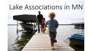
The Citizen Lake Monitoring Program recently partnered with a statistical consulting course at Metropolitan State University to begin researching whether a possible connection exists between the presence of a lake association and water clarity conditions on a lake. This initial work conducted by students was small, focusing only on two counties – Crow Wing and Le Sueur – and using data from 2008-2018.
11% of lakes in Crow Wing County have a lake association – the highest lake association/lake ratio in the state. 6% of lakes in Le Sueur County have an association – the next highest lake association/lake ratio in the state (tied with a few other counties). In total, over 18,000 clarity measurements were analyzed through this study.
The initial results for Crow Wing County show that lakes with an association have higher and more consistent Secchi depth measurements than those without an association for all time points. This indicates that lakes with an association have consistently clearer water in Crow Wing County. The results for Le Sueur County, however, show that lakes with and without a lake association have relatively equal clarity readings over time, indicating that lakes with an association did not have better water clarity.
The differing results highlight how lake conditions and the role of lake associations differ across the state. Analysis of a larger set of counties, widely distributed across the state, and including factors such as the presence of invasive species (i.e zebra mussels) is needed to achieve meaningful results and determine if any correlation exists between the presence of a lake association and water clarity. Stay tuned for more information after further study! Back to top
|
By Jordan Donatell, MPCA Environmental Specialist/Water Quality Lead
Have you ever wondered how we track the quality of our waters on a national scale? Through the years, the Environmental Protection Agency (EPA) has worked with the states, tribes and other partners to carry out a variety of National Aquatic Resource Surveys (NARS) to report on the quality of our waters nationally and explore potential water quality stressors to those systems. Across a five-year period, each different waterbody type is sampled using design and protocol that is standardized across the entire nation. Streams, lakes, wetlands and in 2020 our coastal waters are being monitored nationwide using this approach. What does this mean for Minnesota? Our state does not have traditional oceanic coastal environments, but the great lakes do fall into this National Coastal Condition Assessment (NCCA) program. The Minnesota Pollution Control Agency (MPCA) has collaborated with the Minnesota Department of Natural Resources (MNDNR) and the EPA to conduct the coastal monitoring on Minnesota’s north shore of Lake Superior. Through this effort, water chemistry, sediment, and fish tissue along with other water quality parameters will be collected and analyzed at eight stations randomly located in the near shore waters of the state’s border with Lake Superior. The monitoring stations are generally located in less than 100 feet of water and are within 3 miles of the shoreline. MPCA along with MNDNR will have a crew of four to six people monitor these locations using the national protocols, with a report expected to become available sometime in 2022/2023. Monitoring activities may be scaled back this summer due to COVID-19 social distancing restrictions. If you would like more about the NARS program that defines the condition of our countries waters, please visit their website.
If you have any questions regarding the MPCA's past or current participation in national surveys, please contact Jordan directly: jordan.donatell@state.mn.us
Back to top
|

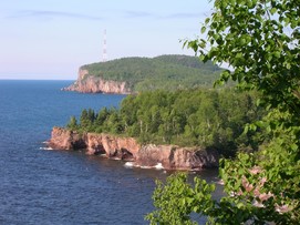
A cold-water algae nicknamed "rock snot" was confirmed in the Poplar River near Lutsen along the North Shore of Lake Superior for the first time during 2018.The freshwater algae, Didymosphenia geminata, is commonly referred to as "Dydimo" and lives in low nutrient, low temperature environments that are common in North Shore streams and Lake Superior. Dydymo is a diatom algae native to the northern hemisphere, but for reasons not fully understood, it occasionally blooms into a thicker, mat form. Thicker didymo mats have formed along the Superior shoreline annually for over a decade; however, it was only in 2018 that didymo was first observed colonizing North Shore streams. It is unclear why the mat formed in the Poplar River. While dydimo is not considered a significant human health risk, it can affect stream habitats and sources of food for fish, and make recreational activities unpleasant.
There is currently a proposal submitted to the Legislative-Citizen Commission on Minnesota Resources to study the recent spread, origin, cause, and economic and ecological threat of nuisance rock snot formation in North Shore streams and Lake Superior to inform management and outreach. We will keep you posted on research developments and information as it becomes available. Back to top
|

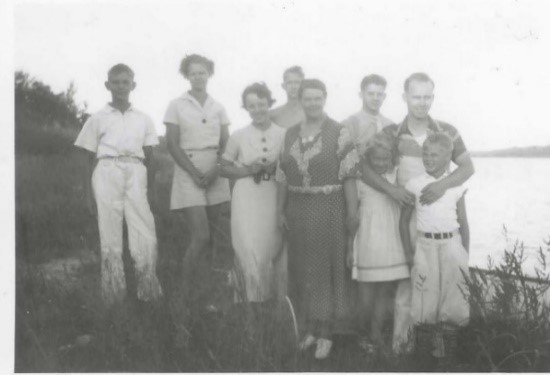
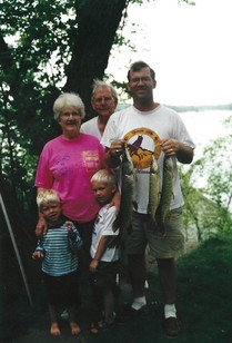
By John Eide, 38 year volunteer on Union Lake
 |
|
The Eide family has had the privilege of participating in the CLMP for 38 years. My mother, Verna Eide, started collecting data for the MPCA on Union Lake, Polk County, northwest Minnesota in 1982. Verna and her husband Alf diligently collected the Secchi disk readings. After my parents passing, my bother Jim, sister Lisa, and I continue the tradition of collecting data. We also get help from the Eide grandchildren. |
|
The Eide cabin has been in the family since the 1920’s. With the strong attachment to Union lake and concern for the water quality, the Eide family has maintained the native trees and grasses with minimal disruption to the shoreline. As mom would say, “It takes a glacier to make a lake.” The collection of data has already begun in 2020. In recent years, the water clarity levels have increased which has necessitated replacing the original cord with a new longer cord. We look forward to recording lake transparency readings for the next 38 years.
Back to top
|
|
 |
|
|