As anglers hit the water this summer, they may catch fish not seen in some places in decades, thanks to state research, funded by the Legacy Amendment, and local projects. Minnesota scientists have studied the fish and other aquatic life across the state, finding obstacles to fish passage to be a major stressor to their ability to reproduce and otherwise survive. Local partners have then worked to remove those obstacles, such as culverts, resulting in fish being able to move through a river system, helping their reproduction rates and providing anglers with good catches.
“Reconnecting river systems is one of the lowest cost, highest return investments in the field of watershed restoration and protection,” said Jeff Jasperson, a stressor identification expert with the MPCA.
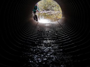
Hitting the wall
This fish tale begins in the spring, when many fish are looking for good places to spawn. They instinctively know the best places generally exist as far upstream into tributaries as they can go. But often they don’t get very far before literally running into a wall, such as a dam, a poorly designed or damaged culvert, or other barrier.
In Minnesota there is a light at the end of the fish barrier tunnel that’s powered by collaborative efforts of many partners. These include the Minnesota Pollution Control Agency (MPCA), Department of Natural Resources (DNR) and other agencies, as well as local organizations and businesses with support from state and federal funding programs.
But before you can fix a problem, you need to find it and study it.
Barriers one of many conditions that stress fish
Every 10 years for a particular watershed, MPCA staff conduct on-the-ground and in-stream surveys to look for conditions that make life difficult for fish and aquatic insects (the larval stage of dragonflies, mayflies and many other flying insects). These potential “stressors” include too much sediment, low dissolved oxygen, lack of habitat, and barriers to fish passage. Staff record their observations and studies in a watershed Stressor Identification Report that helps local, state and federal organizations focus people and money on fixing problems in the watershed.
Reconnecting fish with old spawning grounds
For example, some of the best spawning habitat in the Red River basin is located upstream in the Sand Hill River in what’s known as the beach ridge area of Minnesota. This area is a transition zone where thousands of years ago retreating ancient Lake Agassiz left behind gravelly stream beds and other features that make fish hot to trot. But fish were having a hard time getting to these areas.
Four concrete control structures installed in the 1950s did little to fix erosion and other problems caused by straightening and channeling the river. Instead, the stressor identification work in the Sand Hill watershed confirmed these structures created problems that included actually increasing erosion problems, not reducing them, and keeping fish from excellent spawning habitat upstream.
Over the past several years, local partners have replaced the dams a series of rock arch rapids that help reduce erosion while also allowing fish to move 105 miles up and downstream from the main stem of the Red River to the Sand Hill River headwaters.
“The response was remarkable,” says Jamison Wendel, DNR Red River Basin fisheries expert.
In the spring of 2018, following completion of the project, surveyors found six species of fish upstream of the former dams that were not found in previous studies: channel catfish, smallmouth bass, northern pike, silver redhorse, golden redhorse, and chestnut lamprey. Some fish were spawning directly over the recently installed rapids.
For the full story, visit the MPCA website: www.pca.state.mn.us/featured/breaking-down-barriers.
|
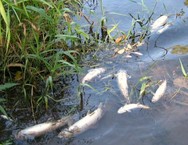
The University of Minnesota estimates about 500 fish kills occur in Minnesota every year, but few are reported. Help scientists learn more about these incidents and how to prevent them by reporting fish kills to the State Duty Officer: 1-800-422-0798. This number is staffed 24 hours, 7 days a week.
Natural causes of fish kills include low oxygen levels due to natural stream conditions and other intrinsic factors; high water temperature; disease; and winter kill.
Human causes include low oxygen levels caused by human impacts; toxic spills; manure runoff; pesticides and fertilizers; and wastewater or stormwater discharges high in temperature.
|
Pilot study finds river to be in good or fair condition
How healthy is the Upper Mississippi River? While states adjacent to the river monitor the waters that drain to it, there has not been a coordinated effort to monitor the country’s largest river by the 10 states that border it. As a result, it’s been difficult to get a clear picture of the overall health of the river and to address larger challenges, such as the dead zone in the Gulf of Mexico around the river’s outfall.
That’s why the Upper Mississippi River Basin Association (UMRBA) worked with Minnesota, Wisconsin, Iowa, Illinois, and Missouri to develop a monitoring and assessment approach to better gauge the condition of the large river.
Each of the states along the Mississippi River has its own approach to monitoring water quality. They have established water quality standards, monitoring techniques, and sampling practices that fulfill federal requirements, but don’t necessarily align easily with other states’ programs.
“Every state is measuring water quality, but they are working with different ‘rulers’,” said Pam Anderson, manager of the MPCA Surface Water Monitoring Section.
For instance, one state may say a stretch of the river has excess phosphorus in the water, but its neighboring state has set a higher threshold, and the same water meets its standard for phosphorus. In addition, the two states may have measured for phosphorus with different tools or sampling practices. For example, one state sampled in the fast flowing main stem of the river, while the other measured in the river’s side channels, which can produce very different results. One monitoring program may monitor after rain events, while another takes a sample each week. Some states may not have developed tools specifically for monitoring large rivers.
These different approaches have prevented river states from being able to gauge the overall health of the Mississippi River and see clearly where there is the greatest need for restoration and protection efforts. UMRBA worked with the five Upper Mississippi states to develop a monitoring strategy to target those efforts and to:
- Address information gaps
- Better identify water quality problems and what is causing them
- Track changes in water quality
Minnesota and Wisconsin undertook a pilot project of the UMRBA monitoring plan to test its feasibility and effectiveness. The two states worked together to assess plant health, condition of fish and bugs, suitability of fish for consumption, and the river’s suitability for recreation. The water was sampled for bacteria, metals, and nutrients. Several agencies collaborated on the study:
- Minnesota agencies studied the river from the Twin Cities to the confluence with the Chippewa River, just south of Lake Pepin.
- Wisconsin covered the stretch south to the confluence with the Root River.
- The Minnesota Department of Natural Resources studied vegetation.
- The Metropolitan Council Environmental Services collected water quality at fixed locations along the reach.
The researchers found the Upper Mississippi River to be in good or fair condition for most parameters, though vegetation was in poor condition in the stretch from the Twin Cities to the confluence with the St. Croix River, which also had excess sediment clouding the water.
UMRBA considers the pilot project a success; the voluntary and collaborative model is achievable. In 2020, work will continue on monitoring the river with Iowa, Illinois, and Missouri collaborating to complete work in the southern portion of the Upper Mississippi River.
For more details of the pilot study, visit the UMRBA water quality webpage and scroll down to the “Recent Products and Publications” section.
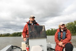
Photo above: Jordan Donatell and Dereck Richter, MPCA environmental specialists, sample the Lower Mississippi River as part of a pilot study with Wisconsin to establish monitoring protocols.
|
We Are Water MN is a popular statewide traveling exhibit and community engagement project that invites visitors to reflect on the experiences of local people and come to a deeper understanding of what taking care of water means to people. Science and history are also included via this 1,000-square foot, hands-on exhibit created by the Minnesota Humanities Center, MPCA, Minnesota Historical Society, and Departments of Health, Agriculture and Natural Resources.
The Cannon River Watershed Partnership will host the We Are Water MN exhibit at the Weitz Center for Creativity at Carleton College from June 20-July 28. The exhibit and events are designed to build awareness of the ways water shapes the history and future of this place and invite people to enjoy and protect the Cannon River. Hours are Tuesday through Friday, noon to 6 p.m. and Saturday 11 a.m.-3 p.m.
As a part of the exhibit, the Cannon River Watershed Partnership and their partners will offer an opening celebration on Saturday, June 29 from 10 a.m.-2 p.m.
Other events include:
- Water-themed visual art shows by local and regional artists (through July 26) at the Northfield Arts Guild and the FiftyNorth Art Gallery.
- Cannon River Historic Photo Exhibit (through July 9) at the Northfield Historical Society.
- Rain Garden Tour, July 13-14, with the Northfield Garden Club.
- Cannon River Nibi Walk, an Indigenous-led, extended ceremony to pray for the water, July 12-15
For more information: Visit the MPCA website at www.pca.state.mn.us/featured/we-are-water-mn-exhibit-moves-northfield or Cannon River Watershed Partnership website at https://crwp.net/.
|