September 2018
The MPCA’s
surface water data webpages, also known as EDA (Environmental Data Access) have been updated. They may look the same but the
information they present is very different. For five years these maps were
static with the only up-to-date material being the chemistry monitoring data.
Now you can
find the latest data on impairments (including a new search), assessments, and
assessment unit IDs (AUIDs).
Note that biological monitoring data, restoration project numbers and MPCA
actions in the watershed have not been updated.
Get
there from www.pca.state.mn.us by
going to Water, Water Data, and then Lake
and stream information. The
Advanced
text and map search is geared toward professionals. Layers on the map can
be turned on and off, you can search by AUID, and you get a little more
information. The
Simple
search map is designed for the general public looking for a particular lake
or stream. In the future
these maps will be updated every two years (after the public comment period on
Minnesota’s Impaired Water List). Chemistry monitoring data continues to be
refreshed nightly. For questions contact Miranda Nichols, MPCA Impaired Waters List
Coordinator, miranda.nichols@state.mn.us.
Back to top
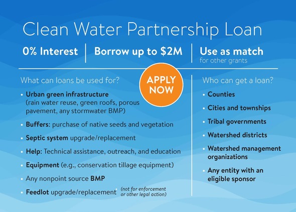
Cities and other government entities can borrow up to $2 million with 0% interest to address non-point source pollution through the Clean Water Partnership program. Loan payback may extend 10 years.
Eligible projects include:
-
Urban green infrastructure such as rain water reuse, green roofs, porous pavement, or any stormwater best management practice (BMP)
-
Buffers: purchase of native seeds and vegetation
-
Septic system upgrades and replacements
- Technical assistance, outreach, and education
-
Equipment such as conservation tillage equipment
-
Any nonpoint source BMP
-
Feedlot upgrades and replacement
Project sponsors can use the loans to implement projects directly or to set up a loan fund for landowners and other stakeholders. Government entities may apply to the Minnesota Pollution Control Agency (MPCA) at any time.
See the program webpage for more information, or contact:
Back to top
BWSR news release, Aug. 27: Continuing statewide work
to shift local water planning to a more coordinated approach, the Minnesota
Board of Water and Soil Resources (BWSR) approved nine new planning grants for
the One Watershed, One Plan program. The Aug. 23 board action allocates up to
$2.2 million in Clean Water Fund grants to fund nine planning projects to
address water issues on a watershed basis.
BWSR has divided Minnesota into 63 suggested “planning
boundaries” based on major watersheds. The legislature set a participation
goal in 2015 of all planning boundaries by the year 2025. So far, the five
pilot plans have been approved by the BWSR board and thirteen groups are
actively developing plans. The new planning grants bring the number of planning
partnerships to 27.
The nine new planning areas are:
-
Hawk Creek watershed, which includes parts of Chippewa, Kandiyohi, and
Renville counties.
-
Joe River and Two Rivers watershed, which includes parts of Kittson and Roseau counties.
-
Mississippi River Headwaters watershed, which includes parts of Beltrami, Cass, Clearwater,
Hubbard, and Itasca counties.
-
Nemadji watershed, which includes parts of Carlton and Pine counties.
-
Redeye River watershed, which includes parts of Becker, Otter Tail, Todd, and
Wadena counties.
-
Rum River watershed, which includes parts of Aitkin, Anoka, Benton, Crow
Wing, Isanti, Kanabec Mille Lacs, Morrison, and Sherburne counties.
-
Shell Rock River and Winnebago watershed, which includes part of Freeborn County.
-
Wild Rice and Marsh River watershed, which includes parts of Becker, Clay, Clearwater,
Mahnomen, and Norman counties.
-
Zumbro River watershed, which includes parts of Dodge, Goodhue, Olmsted, Rice,
and Wabasha counties.
More information about the One Watershed One Plan program,
including a map of the participating watersheds, is on BWSR’s website: www.bwsr.state.mn.us.
Back to top
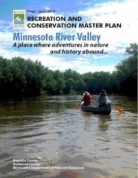 Leading up to the next phase of the Minnesota
River Valley Recreation and Conservation Project, an opportunity for public comment continues until Sept. 30 with a short online survey The survey seeks input on preferences for outdoor recreation uses and education or interpretive themes in a potential State Recreation Area for the Redwood and Renville county
river valley area.
In 2014, the legislature directed the DNR to develop a master plan for the area two miles either side of the Minnesota River in Redwood and Renville counties. They have been working since 2009 to identify conservation and recreation management concepts that will meet a variety of interests.
Interests include the changing needs of outdoor recreationists, quality wildlife habitat in the Minnesota River Valley area, and the many sensitive animals and plant communities. A key goal is to continue respecting private property rights while supporting diverse local economies and healthy communities. Implementation strategies identified in the plan include exploring options for a new State Recreation Area (SRA) in the valley.
Back to top
|
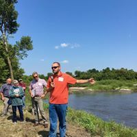
Exploring
the unique opportunities and challenges facing southwest Minnesota, the
Minnesota Board of Water and Soil Resources (BWSR) gathered local, state, and
federal conservation staff for its annual board tour Aug. 22 in Rock and
Nobles counties. The board visited a number of projects focused on flood
recovery and water quality improvements.
Tour stops included wellhead areas in Worthington and Adrian,
the recently-restored Summit Lake in Nobles County, and a presentation in
Luverne highlighting disaster recovery efforts following significant flooding
in 2014. Local partners included the Okabena-Ocheda Watershed District, Rock County SWCD, Nobles County SWCD, Minnesota Rural Water
Association, and Rock County Rural Water District.
The 20-member BWSR board includes representatives from state
agencies, local governments, and citizens. Board tour destinations rotate each
year to highlight different regions of Minnesota. The projects featured during
the annual tour illustrate how successful partnerships between federal, state,
and local governments and private landowners safeguard and enhance Minnesota’s
soil and water resources. Photos from the Board Tour can be found on Facebook
here: https://goo.gl/XjgnyC. - BWSR news release, Aug. 23.
Back to top
|
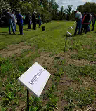
With just enough rain since they were planted Aug. 2, about 36
varieties of cover crops were emerging in a long row of small plots at a
"soil health tour" Aug. 29 in Stearns County. Viewing the plots
across Hwy. 15 from Luxemburg Feed Service, farmers and agency staff listened
as Rick Tamm of Byron Seeds described the varieties and what they can do, from tilling soil, fixing nitrogen, scavenging
nitrogen, ground cover, livestock forage, and building soil organic matter.
The plots
wrapped up a day-long tour that included cover crops at the Lee Zabinski farm,
no-till at Bechthold Dairy, Alan Olmscheid's hayable buffers, and Francis
Krippner's rock-surfaced stream crossing. When considering cover crops,
Tamm advised farmers to first determine the goal before choosing what type to
use. Tour sponsors included: Stearns SWCD, Sauk River Watershed District, and
NRCS.
Back to top
|
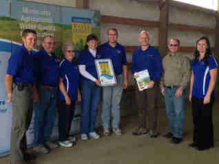
The National Association of State Departments of
Agriculture presented its first public-private
partnership award in Hartford, CT to the Minnesota Dept. of
Agriculture's Agricultural Water Quality Certification Program
and Land O’Lakes. The public-private
partnership was established in 2016 with the shared goal of protecting and
improving water quality in Minnesota.
Certification is a voluntary opportunity for farmers and
agricultural landowners to take the lead in implementing conservation
practices that protect our water. It uses a risk-assessment process
where risks to water quality are identified and treated. When an identified
risk is mitigated it is counted as a new practice. Farms that install and
maintain approved farm management practices will be certified and in turn
obtain regulatory certainty for a period of ten years. Photo: Certification
presentation at Dorrich Dairy east of Glenwood (L-R): Greg Vold, Richard
Vold, Dorothy Vold, Suzanne Vold, Brad Vold, of Dorrich Dairy; Brad Jordahl
Redlin, Grant Pearson, of MAWQCP; Holly Kovarik, Pope SWCD.
To date, 74 of Minnesota's 87 counties have at least
one water-quality certified farm. Current certification numbers:
- 645 certified producers
- 407,534 certified acres
- 1,244 new practices implemented
Impact on water quality:
- 21,474 tons of soil saved per year
- 57, 542 tons of sediment reduced per year
- 25,194 lbs. of phosphorus prevented per year
- Up to 49% estimated reduction in nitrogen loss
The purpose of the NASDA Public-Private Partnership Award is
to recognize National Association of State Departments of
Agriculture (NASDA) Partners Program organizations that have
partnered with a state to implement a program, project, or service that
positively impacts the state. The collaboration with Land O’Lakes, Inc.
provides the opportunity for the state to develop delivery of
conservation services via private industry, with the potential to take
resource stewardship to a greater scale.
|
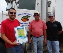
Stoney Brook Farms is Minnesota's
600th Water Quality Certified farm
Stoney Brook
Farms, Inc. is a family farm in Foley that grows sweet corn,
pumpkins, squash, peas, green beans, and fall decorative items such as indian
corn and gourds. They have also started hosting Harvest Fun Days with a
pumpkin patch and a corn maze. Stoney Brook Farms has
taken an innovative approach to managing their farm, with a focus on water
quality and soil health practices. Some examples of their practices include
no-till planting, residue management, cover crops, and crop diversity. Check out Benton County
SWCD's full article
for more information. Photo left to right: Brad and Mark Chmielewski of Stoney Brook Farms, Inc.
accepting their MN Water Quality Certified Farm sign from Benton SWCD
Technician Casey Gwost. - MAWQCP Insider newsletter.
Back to top
|
The Minnesota Department of Agriculture is
seeking public input on the revised Water Quality Best Management Practices
(BMPs) for all agricultural herbicides and revised Water Quality Best
Management Practices for Acetochlor. Currently, the MDA is in the process of
revising these BMPs in response to current agricultural practices. The current
BMPs can be viewed HERE. The comment period is open until Oct. 4.
New runoff risk tool
determines best manure application timing
The Minnesota Dept. of
Agriculture, in partnership with the National Weather Service has designed
a new tool for those applying manure in Minnesota called the Minnesota
Runoff Risk Advisory Forecast. The interactive map is designed to help farmers
and custom manure applicators decide on the optimal time to apply manure by
predicting or modeling when runoff events are likely to happen. As a bonus, the
tool also provides forecasted precipitation amounts, as well as soil
temperatures at 2 and 6 inches of depth to help with manure application
decisions. Click
here to read more.
MPPA approves St. Louis River Watershed Restoration and Protection Strategy
The St. Louis River Watershed Watershed Restoration And Protection Strategy report was approved
by the MPCA on Aug. 9. The final WRAPS report is posted on the St. Louis
River Watershed web page.
Three researchers
presented their findings on “Saturated Buffers as a strategy for N abatement
in tile drainage” at the Sept. 19 Basin Alliance for the Lower Mississippi in Minnesota meeting. Dave Legvold is an
environmental educator, farmer and mentor. Legvold has devoted his life to
teaching, learning about, and improving the quality of the environment. He has
been working his family farm of 800 acres of rolling land outside of
Northfield, Minn., since 1976. Claire Hinther, guest faculty at St. Olaf
College in Northfield, has been researching saturated buffers on Legvold’s
farm. She has worked in partnership with the Dept. of Agriculture,
Ellingson Drainage, Ecosystem Services Exchange, and St. Olaf College to amass
a significant amount of data to verify the efficacy of various kinds of buffer
plantings. Laura Bender, PhD candidate working with Dr. Chris Lenhart of the
University of Minnesota on phosphorous abatement in buffers, discussed a
novel approach to methodologies to remove nutrients from agricultural runoff.
Back to top
|