Transparency Times, September 2018
Minnesota Pollution Control Agency sent this bulletin at 09/12/2018 08:11 AM CDT
Reflections on Reflections (Survey!)
Send us your best photos for the 2020 CMP calendar!
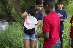
 Expanding Volunteer Water Monitoring in the BWCA
CLMP Data Essential to U of M Program Using Satellites to Monitor Lake HealthBy Leif Olmanson PhD, Researcher & Benjamin Page, Research Fellow, University of Minnesota
|


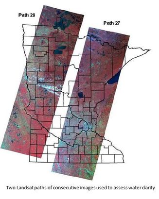
The University of Minnesota Remote Sensing and Geospatial Analysis Laboratory and the Water Resources Center have been using Citizen Lake Monitoring Program (CLMP) Secchi disk data for ~25 years in our work to develop a groundbreaking method for identifying lake water quality using only satellite imagery. Through this work, we have found that the health of a waterbody can be assessed by examining imagery collected by NASA’s Landsat satellites. These satellites are equipped with sensors with spectral bands that go beyond detecting the red/blue/green portion of the electromagnetic spectrum including the near-infared and shortwave infared regions. Using different band combinations, we can identify optically active particles present in surface water such as chlorophyll-a, suspended sediments and dissolved organic matter – elements which can reveal the health of the waterbody.
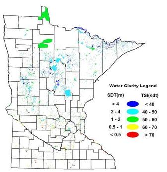
Applying the satellite imagery model to lakes across Minnesota requires regular calibration, using water clarity data collected on the ground by CLMP volunteers. We compare Secchi readings taken by CLMP volunteers (generally within a 1-3 day window from the satellite overpass of a particular lake) with the image generated by the satellite. Correlations between Secchi readings and lake images are used to calibrate the water clarity model. So far seven statewide water clarity assessments have been completed on over 10,000 lakes, from 1975 through 2008. The data is currently available in a Google Maps like Lake Browser that can be accessed at http://lakes.rs.umn.edu/, with 2010 and 2015 results coming soon.
|
 With the increasing number of NASA and European Space Agency satellites, we have entered into a new era of remote sensing with sensors capable of measuring more water quality variables more often. As these new satellites become operational, we have the opportunity for continuous monitoring of Minnesota’s surface waters on a weekly to biweekly basis. To take advantage of this opportunity, we are transferring our conventional methods to an automated image processing system, using the data from CLMP to build a near real-time water quality monitoring system in a high performance computing environment. This system is being funded by the Environment and Natural Resources Trust Fund and will provide citizens, researchers and agencies the data needed to help improve decision-making for fisheries and lake management. We intend to implement additional water quality parameters in our mapping objective, such as chlorophyll-a and other algal indices, colored dissolved organic matter (CDOM) as well as lake surface temperatures. We encourage CLMP participants to take water clarity readings on days when satellites pass over their region of Minnesota. Our goal is to work more closely with CLMP staff to make satellite overpass information for a particular lake easily accessible. The efforts achieved already by concerned Minnesota citizens have proven to be an invaluable resource for Minnesota and remote sensing of water quality research. As we move forward with the near real-time water quality monitoring system, data collected by CLMP will be even more essential for validation and to improve water quality models. |

Waterway Jay paddles for progress
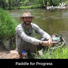 Jay Gustafson - aka 'Waterway Jay' - quit his job in 2017 as a business analyst to canoe each of Minnesota’s 34 state water trails, paddling roughly 4,500 miles to raise awareness of the threats facing the health of our state’s freshwater ecosystems. As of early August, Jay had completed 25 of the state's 34 water trails. Through his 'Paddle for Progress' project, Jay aims to galvanize Minnesotans to take pride and ownership of the freshwater ecosystems that make our state unique. He is also carrying a Secchi tube with him as he paddles, taking water clarity readings along the way! Watch for a short film scheduled to be released this winter by Adventure Minnesota Films that will follow Jay's journey. You can find out more and track Jay's current location on the Paddle for Progress website. |
Assessing "Unsewered areas" in Minnesota
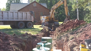 What is an unsewered area? This is a great question! At the MPCA we look at clusters of five or more homes/businesses within a ½ mile that have inadequate treatment of their wastewater. We consider clusters of individual septic systems that are potentially failing, inadequate, non-existent, or simply unknown. We have had areas in the past where entire communities collected untreated wastewater and discharged it to a nearby ditch or wetland. In the 1800’s, this was a common practice in rural areas. We are trying to assess how many of these areas might still exist today. Raw untreated wastewater…aka sewage…in our surface waters has the potential to carry viruses, bacteria, and parasites. Historically, large amounts of untreated sewage caused major health epidemics like Cholera, Typhoid Fever, and Dysentery. Today these risk are much smaller, but the potential for human health impact still exists. Untreated or under-treated sewage may also contain higher concentrations of phosphorus, nitrogen, and ammonia and contribute to water quality impairments in our lakes, rivers, and streams. To figure out how big the problem could be, the MPCA began looking through regional lists of areas of concern, partner agencies lists, and the 2010 census of all named places in Minnesota. We then took a long list of nearly 6000 areas and sent them to all 87 counties for the counties to give us their input and data. With the help of each county, we were able to sort through records from as early as the 1940’s and determine where we had compliant systems, where we had questionable systems, and where we had no records of systems. This helped us cut the list down to a little over 1280 areas. While this might seem like a lot of areas that are unsewered, the reality is 80% of these areas are on the list due to lack of records. As counties began implementing the Subsurface Septic Treatment Program and creating ordinances, there was often haphazard documentation or records retention. So the big question is, what is the MPCA doing now? We are working with the counties to prioritize completing assessments on these areas to determine if the current systems are compliant. This is often done with county inventories or community assessments. Both are tools the counties can use to get a better understanding of the systems in the entire area, instead of one by one when ordinance triggers require a septic inspection. Counties can apply for Clean Water Legacy Grants to complete inventories in areas with a downstream impairment. They can be done county-wide or in a specific geographical area, such as by watershed. Community Assessments are typically used in incorporated areas or densely populated unincorporated areas to determine the compliance and potential needs of the area. It looks at existing systems, rate of noncompliance, and if there is potential for individuals to upgrade onsite, or if a community wastewater treatment system is needed. This work is time consuming, but necessary to determine the true scope of noncompliance. We have already eliminated nearly 200 areas by working with the counties to do further investigation. We’ve increased the number of unsewered projects the MPCA is working on from 17 to 38 in two years. And while we have a long road ahead of us, being able to partner with counties to do some of the investigative work has made great strides in getting more accurate information and moving ahead much faster than originally thought! If you have questions about the MPCA's unsewered areas work, or you would like to find out more please contact Lisa McCormick at 320-248-1210 or lisa.mccormick@state.mn.us |

Thank You Citizen Volunteers for the Important Work You Do
By Bruce Paakh, 30 year CLMP Volunteer & retired MPCA Limnologist, Aquatic Ecologist
In November of 2015 I retired from my 32-year career with the MPCA at the Detroit Lakes Regional Office. One of my most important and enjoyable roles was that of Water Quality Monitoring Coordinator. Early on my supervisor, Jim Ziegler, instructed me to develop and provide training for people to properly collect data from our lakes and rivers. He prescribed to the logic that a well-trained “army” of citizen and local government monitoring experts could amass far more data than I could ever hope to collect on the job and at the same time they could become the local experts and advocates for water quality protection and improvement. Promotion of the CLMP and CSMP was an important part of this strategy and these programs have been hugely successful THANKS to your involvement and commitment.
In carrying out this vision, I worked with dozens of COLAs, 100s of lake associations and 1000s of folks interested in or engaged in collecting lake and stream water quality data. The dedication and commitment to our water resources by these groups and individuals that I witnessed during my career was humbling. One of my biggest regrets in retiring (besides missing out on the awesome lake association potluck lunches and dinners) is that there wasn’t a great way to say thank you to all those devoted individuals who have participated in collecting data and who have promoted the protection of our water resources. It is you folks that are on the front lines who commit to collecting the data that tells the story about the condition of a lake or stream, who attend the zoning meetings to make sure development happens in a responsible way, who set the example for your neighbors with shoreline buffers, who keep the association members informed about trends in water quality and who work toward reducing the risk of aquatic invasive species. THANK YOU for your collective efforts to protect our environment. The quality of our lakes and streams directly benefit from what you do.
|
In 1993 I
developed a monitoring program for the Becker County COLA that provided for the
volunteer collection of total phosphorus and chlorophyll in addition to the
Secchi disk. That program took off and spread rapidly to about 9 other COLAs
before I handed it off in 1999 to the contract lab that was conducting the
analysis for the program - RMB Environmental Labs. Since that time over 1000 lakes have
participated in the program and many have built an impressive data set that
serves as a strong water quality benchmark for a host of various uses (trend
assessments, goal setting, condition/impairment assessment, etc.). The data
collected from this program is often the only phosphorus and chlorophyll data
for many of the lakes who have participated. THANK YOU to these program
participants (often the CLMP volunteer for the lake). You are one of the early
pioneers in collecting this type of information on your lake and the importance
of it cannot be overstated. 30 years of collecting Secchi data in the CLMP for me has been an extension of who I am as a scientist and my passion for protecting the environment. I first started collecting Secchi and other lake data (on Lakes Irving, Bemidji, Wolf and Andrusia) and Mississippi River data in 1979 as a grad student at Bemidji State University, as part of an EPA grant. So when I bought my current lake home in 1986, collecting Secchi data was an important part of the process of learning about and tracking the lake's condition. Data is absolutely needed to understand how an individual lake or stream behaves and reacts to various climatic conditions (excessive precipitation, drought, late or early spring warmup, unusually hot or cool summers, etc.). Each lake and stream has its own “personality” in the way it responds due to the host of variables including watershed size, land use, climate, biology, chemistry, soil type, groundwater interactions, etc. I have had folks tell me things like, “20 years ago the lake was so clear you could read the date on a quarter down 15 feet” or “you could have read a newspaper down 10 feet.” Now those are interesting ways to describe water clarity but they would be tough procedures to try to duplicate. Aren’t you glad we aren’t dropping a quarter or book down on our rope? The CLMP and CSMP are
like fraternities for us who care deeply about our lakes and streams. Because
we share those values I have always felt a strong bond with the many volunteers
I have met over the years. Thank you again for all you do. In God we trust, all
others need data.
|
|
|
|
|
|
Preferences • Help • This email sent using GovDelivery (800-439-1420) |
||