
The Minnesota Dept. of Natural Resources (DNR) is accepting applications for its
Conservation Partners Legacy expedited grants program. The expedited grant cycle funds eligible activities that
restore or enhance forests, wetlands, prairies, or habitat for fish, game, and
wildlife on public lands/waters in Minnesota. Lands must be open to all seasons
of hunting and fishing. Grant requests may range from $5,000 to $50,000, with a
maximum total project cost of $575,000. Nonprofit organizations and government
entities are eligible to apply, and a 10% match of non-state funds is required.
Apply online by 4 p.m. Jan. 19. Funding for this program comes from
the Outdoor Heritage Fund.
|
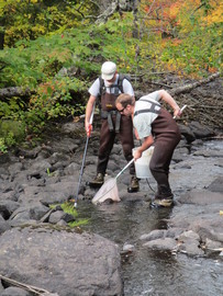
While scientists can’t ask fish and bugs how clean the water
is, they can count their numbers and species to help find that out.
From mid-June through September 2017, biological
monitoring crews from the Minnesota Pollution Control Agency (MPCA) sampled a
total of 921 sites in rivers, streams, and ditches across the state for fish
(420 sites) and macroinvertebrates (501 sites).
Measuring and evaluating the health of fish, macroinvertebrates and plants
helps to distinguish between naturally-occurring variation, and changes caused
by human activities.
The north biological monitoring unit sampled sites in the
North Fork Crow River, Rainy River Headwaters, Rainy Lake and Rapid River watersheds.
The south unit sampled in the Blue Earth, Cottonwood, Redwood, Pomme de Terre
and Snake River watersheds, and surveyed a series of
sites on the St. Croix River.
Challenging weather
Throughout the summer abnormally low and high rainfall posed
challenges. In the south, more than 13
inches of rain fell in the Redwood River watershed during an August storm. In
northern Minnesota severe drought left streams with very little water or completely
dry.
Despite the difficult conditions, crews still were able to
collect good samples from a majority of locations. The south unit collected 36
species of fish in the lower reaches of the Cottonwood River, including
shovelnose sturgeon, walleye and flathead catfish. One visit on the St. Croix
River found 38 unique species, and many stations had greater than 30 specific
groups. The north unit collected 35 fish species in the North Fork Crow River, and
three other locations had more than 30 species.
Finding rare species
The south unit identified several rare species during the St.
Croix River surveys, including river darter (endangered), pugnose shiner
(threatened), blue sucker (special concern), gilt darter (special concern), and
lake sturgeon (special concern).
The north unit found several rare species including pugnose
shiner in the Ottertail, Pine and North Fork Crow River watersheds, northern
brook lamprey (special concern) in the Ottertail and Lake of the Woods watersheds,
lake sturgeon in the Little Fork watershed, and least darter (special concern) in
the Pine River watershed.
Water quality monitoring
The MPCA’s water quality
monitoring unit collected data from about 370 stream and 630 lake sampling
events in the same major watersheds as well as the Rainy and St. Croix Rivers,
several streams in central Minnesota, and dozens of lakes for routine condition
monitoring. Local partners and citizen volunteers also helped by collecting
water samples and from lakes and streams in many watersheds.
The water quality monitoring unit also participated in the National Lakes
Assessment. The 150-lake random survey across Minnesota focused on determining
the suitability of lakes for recreation, aquatic life and habitat.
|
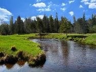
The Upper/Lower
Red Lake watershed in northern Minnesota is one of the few in the state
where large areas are still in their natural state and the waters in pristine
condition. As such, many of the water quality strategies here focus on
protection instead of restoration.
The Upper/Lower Red Lake watershed
covers 1.2 million acres, mostly in Beltrami County with portions in Koochiching, Itasca, and Clearwater counties. Less than 1%
of the land within the watershed is used for crop production. About 6% is used
for pasture or hay. Upper and Lower Red Lake together encompass an area of 288,800 acres. They are two
of the largest lakes in the state and comprise 24% of the watershed’s surface
area. And, despite years of effort to increase drainage, wetlands still cover
48% of the watershed. Only 1.5% of the watershed is developed. A substantial
portion of the watershed is comprised of reservation land that is part of the
Red Lake Indian Reservation.
Vast expanses of wetlands and forests, combined with very little
development, results in generally good water quality across the watershed. However,
there are issues that negatively impact water quality, and fish and aquatic
insect communities.
While the watershed’s many wetlands play a major role in maintaining
water quality, they can have some negative effects as well. For example, rain
storms can flush organic matter and water to streams, where the influx can lower dissolved
oxygen concentrations, which in turn can stress fish and aquatic insects. Wetland
streams are characterized by fine sediments and slow currents. These conditions
can reduce stream channel development and habitat complexity, which is not
necessarily good for supporting diverse communities of fish and aquatic
insects.
Upper and Lower Red Lakes are relatively shallow with vast surface
areas. Nutrients in the lake bottom sediments are subject to becoming
re-suspended during windy and choppy conditions and result in nuisance algae
blooms.
Bacteria concentrations are a concern in 10 stream sections that exceeded thresholds set
for safe swimming. With so little development, a likely cause of elevated
bacteria levels could be from wildlife such as waterfowl and beavers.
While some
impairments are likely due to natural factors, residents can take actions to
assist in the recovery and protection of streams and lakes. These include:
- Restore riparian zones and shorelines using native vegetation, trees, and shrubs
- Protect vegetated buffer zones, shorelines, and exceptional aquatic habitats
- Adopt best management practices to improve stream sections with sedimentation and erosion issues and to prevent additional sedimentation
- Restrict livestock access to streams
- Continue chemistry and biological monitoring to evaluate and document declining or improving conditions
- Continue to monitor dissolved oxygen in several stream sections to determine if low dissolved oxygen concentrations are affecting biological communities
For details, see the MPCA monitoring
and assessment report for the Upper/Lower Red Lake watershed online.
|
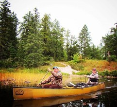
When picturing the majestic and massive Boundary
Waters Canoe Area Wilderness or the Superior National Forest, it’s easy to see
them as distinct natural resources and valued recreational destinations. It’s
harder to picture them as part of something even bigger.
At 2,954 square miles, the Rainy
River-Headwaters watershed contains large portions of the Boundary Waters
and Superior National Forest as well as much of northeastern Minnesota. Filled
with massivet tracts of upland and lowland forest, the watershed is dotted with
more than 1,200 lakes and 400 streams.
The watershed’s undeveloped nature – 85% under state and
federal ownership – is undoubtedly a key reason for the prevalence of high
water quality. Because
forests and wetlands dominate the landscape, monitored stream resources show
exceptional biological, chemical, and physical characteristics. Most support
a diversity of fish and wildlife species, habitat for aquatic and wild life,
recreational opportunities, and timber production.
Overall,
the watershed’s water quality conditions are good to excellent. The highest
quality stream resources, based on aquatic life, habitat, and water chemistry
are: Bezhik Creek, Denley Creek, Little Isablla River, Mitawan Creek, Snake
River, Jack Pine Creek, Cross River, Moose River, and Stony River.
A few
stream sections and lakes are impaired, meaning they fail to meet water quality
standards all the time. They are typically limited to the lower reaches of
stream and lake systems where likely human stressors from land use practices
may accumulate. Stressor examples include historical and recent forest cover
changes, urban and industrial development, and wetland drainage.
Key
impairments found in lakes and/or streams include high levels of sediment
affecting water clarity, E. coli
bacteria that may make the water unsafe for recreation like swimming, and
mercury in fish tissue that requires limits on consumption.
Other
highlights include:
- Biological monitoring results identified numerous sensitive fish and macroinvertebrate species in many of this watershed’s drainages and this is an indicator of good water quality.
- Several streams, including Bezhik, Cross, Denley, Jack Pine, Little Isabella, Mitawan and Snake Creek and River, had exceptional biological communities that should be protected.
- All 245 monitored lakes, except for Blueberry Lake near Ely, had good-to-excellent water quality. The Blueberry Lake impairment was deemed to be a result of
natural conditions.
In 2014, the MPCA began intensive watershed monitoring of
this watershed’s surface waters, including Ash, Bear Island, Cross, Dunka,
Dumbbell, Isabella, Island, Kawishiwi, Little Indian Sioux, Little Isabella,
Moose, Shagawa, and Stony rivers. The MPCA partnered with Cook and Lake County
Soil and Water Conservation Districts (SWCDs) and Vermilion Community College
to conduct water chemistry sampling at 13 streams. The MPCA, Lake County SWCD, University
of Minnesota-Duluth, National Park Service, and local volunteers monitored 60
lakes. The results of the monitoring were used to assess all surface
waterbodies for aquatic life, recreation and fish consumption (where sufficient
data were available).
Results
of this recent research are included in the Rainy River-Headwater Watershed Monitoring
and Assessment Report.
|
“How’s the water? Is it getting better or worse?” are common
questions to MPCA scientists. Thanks to a statewide monitoring network, funded
in a large part by the Legacy Amendment, scientists now have the long-term data
to answer those questions.
People can use the data to figure out sources of
pollutants, and how best to curb them. The data can then help detect whether restoration
efforts are working, as in the Poplar
River story in last month’s edition. Protection of healthy waters is also
important because restoration is usually more difficult and expensive.
So how is the water, and is it getting better or worse? In general,
phosphorus and total suspended solids concentrations in Minnesota’s larger
rivers are decreasing or staying the same, while nitrate concentrations are staying
the same or increasing. However, because flows have been increasing in
some rivers, the total amount of phosphorus, total suspended solids, and
nitrate may be increasing even when concentrations stay the same
Water quality also depends on location, as shown by the maps below. Rivers and streams in the central, north-central and northeastern parts of Minnesota – where more of the forested land and wetlands are intact – generally have the best water quality. The watersheds in the western and southern areas – where the land has been significantly changed for farming and other development – have the poorest water quality.
These trends are documented by the MPCA’s Watershed Pollutant Load Monitoring Network (WPLMN), which is designed to measure and compare pollutant load information from Minnesota’s rivers and streams, and track water quality trends..
This network uses a multi-agency monitoring design that combines site-specific streamflow data from the U.S. Geological Survey and the Minnesota DNR. Local partners and MPCA staff collect water quality data at 200 sites, which is paired with the stream flow information to compute pollutant loads. A
pollutant load is the amount of polluting material that a stream has
transported over a given period of time.
To best summarize the average quality of water that has flowed through a stream or river system, a statistic known as the flow weighted mean concentration (FWMC) is often used. The FWMC is computed by dividing a pollutant load by the volume of water that passed the monitoring location over the monitoring period. In simplified terms, the FWMC is like collecting all the water that passed a monitoring site into a huge pool and taking one sample. This statistic can be used to determine how clean or polluted a river is on average, allowing for the equal comparison of stream water quality between watersheds differing in size or streamflow volume.
For more information about the monitoring network, please see the WPLMN webpage, or contact MPCA hydrologist Patrick Baskfield at 507-344-5240 or pat.baskfield@state.mn.us.
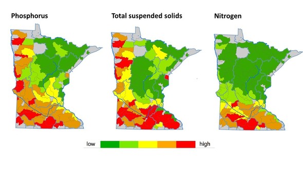 In the maps above:
- The left map shows the average FWMCs from 2007-2015 for total phosphorus in Minnesota’s major watersheds. Phosphorus in excess amounts can lead to an overabundance of algae that can reduce water clarity and lead to low levels of dissolved oxygen, harming aquatic life and recreation.
- The middle map shows the average FWMCs from 2007-2015 for total suspended solids. Excess sediment in rivers can block sunlight needed by beneficial plants, smother certain insects and fish eggs, reduce the diversity and number of fish, and carry excess nutrients and other harmful substances.
- The right map shows the average FWMCs from 2007-2015 for nitrate-nitrite. Nitrogen can be harmful to aquatic insects and other life in waters, and can also be unsafe in drinking water.
 After 40 years of combined service to the state, MPCA Assistant Commissioner Rebecca Flood has announced she is retiring, effective Feb.16, 2018. Flood, in the photo at right, served at the Metropolitan Council from 1978 to 2008, responsible for ensuring that metropolitan area wastewater treatment plants were meeting environmental requirements. She joined the MPCA in 2008 as the assistant commissioner for water policy.
“For the past nine years, Rebecca has provided stellar leadership and wise counsel to four Commissioners and the agency on a wide range of water policy issues, ranging from wild rice water quality standards to septic tank installer licensing,” said MPCA Commissioner John Stine. “She leaves behind a particularly valuable legacy in establishing and strengthening coordination among state agencies on the myriad of interconnected issues involving water protection and clean water funding. She has championed the development of Minnesota’s nation-leading Watershed Approach that has led to the 10-year cycle of water assessment.”
Shannon Lotthammer will serve as the new assistant commissioner for water policy effective upon Flood’s retirement. Lotthammer has been with the MPCA for more than 20 years, and has served as the Environmental Analysis and Outcomes (EAO) division director since 2012. In that role, she has demonstrated great skill in leading the agency in establishing science-based water quality standards, expanding air quality monitoring, revising the wild rice rule, helping adapt MPCA work to address environmental justice, and championing a variety of improvement projects.
Todd Biewen, assistant EAO director, will move up to take Lotthammer’s place. He has worked at the MPCA for nearly 30 years, serving most recently as Assistant Division Director (ADD) for both the EAO and Remediation Divisions. His MPCA career began in the Air Quality Division for 10 years and then in EAO when it was created in 1998. He served as both a supervisor and manager in the EAO Division before becoming assistant director in 2008.
|
Orwell Lake in Otter Tail County is meeting water quality standards for nutrients, thanks to major decreases in phosphorus from upstream wastewater treatment plants (WWTPs).
Orwell Lake is a 590-acre impoundment on the Otter Tail River in west-central Minnesota. The lake is a protected wildlife sanctuary, and is popular for fishing and hunting.
The Pelican Rapids WWTP discharges its effluent to the river 30 miles upstream. More than 10 years ago, the MPCA issued a stricter phosphorus limit to the Pelican Rapids WWTP because of increased algal growth in Orwell Lake. Algal blooms can make water unattractive for recreation such as boating and unsuitable for fish and other aquatic life.
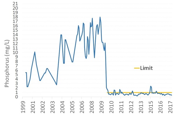
Since then Pelican Rapids upgraded its facility, and has reduced its effluent phosphorus concentration and load by more than 90%, from 10-18 mg/L to less than 1 mg/L (chart below).
The city of Fergus Falls also discharges its effluent to the Otter Tail River, about 10 miles upstream of Orwell Lake. It too upgraded its facility to meet a stricter phosphorus limit, and has reduced its phosphorus discharge by about 80%, down to less than 1 mg/L.
Recent water monitoring shows that Orwell Lake is meeting nutrient water quality standards for lakes. Prior to the phosphorus limits in the wastewater discharge permits:
-
Phosphorus levels in Orwell Lake were historically at 75 micrograms per liter. Current levels average about 47 micrograms per liter.
- Chlorophyll-a levels averaged 36 micrograms per liter in Orwell Lake, indicating nuisance conditions (chlorophyll-a, the green pigment found in algae, is a way to measure algae levels). Current levels average 12.6 micrograms per liter.
Since these decreases in phosphorus, the river and downstream waters are faring much better. Because Orwell Lake, along with the Dayton Hallow reservoir, are meeting standards, the MPCA does not anticipate more restrictive phosphorus limits for the Pelican Rapids and Fergus Falls WWTPs.
“This is a great example of how cities reducing their phosphorus discharges can make a positive impact downstream,” said Mark Schmitt, director of the Municipal Division for the MPCA.
Monthly phosphorus effluent concentration (mg/L) for the Pelican Rapids wastewater treatment plant
The MPCA closed its Willmar, Minn., office on Dec. 8. All staff will keep their jobs. Six staff members assigned to the office will be re-assigned to alternate work locations, or will work from the Marshall MPCA office.
One of seven MPCA regional offices outside the Twin Cities metro area, the Willmar office opened in 1999 at 201 28th Ave. SW. In 2006, it moved to 1601 E. Hwy. 12. With the fewest staff among regional offices, MPCA officials decided that closure would reduce costs with minimal effect on services.
Along with the MPCA office in Marshall, the Willmar office served 18 counties in southwestern Minnesota. The Marshall office, which opened in 1976, will continue to work with citizens and businesses in protecting the environment.
Other regional offices are located in Duluth, Brainerd, Detroit Lakes, Mankato, and Rochester. More information about these MPCA offices is available on the agency's MPCA offices webpage.
|