
The Legislative-Citizen Commission on Minnesota Resources recently selected 65 projects totaling $45.3 million for recommendation to the 2018
Legislature for funding from the Environment and Natural Resources Trust Fund.
This fund derives from lottery proceeds and investment income. The commission
whittled down the original list of 217 proposals totaling $183 million to the
65 recommended through a multi-step competitive process.
If approved by the Minnesota
Legislature and Gov. Mark Dayton, the funded projects would begin in July 2018.
The projects range from $30,000 for the
“Get Outdoors After School” initiative to connect underprivileged youth to the
outdoors, up to $3.25 million for the DNR’s Scientific and Natural Areas that preserve natural features
and rare resources of exceptional scientific and educational value.
Among the recommend projects is one led by the Minnesota Pollution Control Agency (MPCA):
$700,000 for a Wastewater
Treatment Plant Optimization Pilot Program,” an effort to improve existing
processes for removing nutrient pollutants to meet water quality standards
without adding substantial new infrastructure.
|

The Lessard-Sams Outdoor Heritage
Council recently decided to recommend $107.2 million in funding for 45
proposals to the 2018 Minnesota Legislature. The council makes annual
recommendations to the legislature on appropriations from the Outdoor Heritage Council,
which is funded by the Clean Water, Land and Legacy Amendment.
The council received a total of 52 requests
totaling more than $338 million in funding for 2018-19, far exceeding the $100
million expected to be available for projects.
Proposals making the final cut range from $539,000
for the Lake George Dam and Rum River Erosion project, a proposal from Anoka
County Parks to replace the dam and repair two severe erosion sites, up to
nearly $10 million to continue the Minnesota Board of Water and Soil Resources
program, Reinvest in Minnesota (RIM), to restore wetlands.
Visit the Minnesota’s
Legacy website for more information about environmental funding in
Minnesota.
|

The MPCA will be
awarding nearly $2.8 million in grants to 10 projects under the federal Clean
Water Act Section 319 program. The U.S. Environmental Protection Agency (EPA)
awarded the funds in the 2017 federal fiscal year to address nonpoint
source pollution, which derives from many indirect sources such as runoff. Project
sponsors must match the grants by at least 40% of total costs, bringing the
total investment to nearly $4.8 million.
Addressing runoff from both agricultural and stormwater
sources, the projects plan to reduce nutrient, bacterial, and sediment runoff
from nonpoint sources. Selected from a pool of 21 eligible applicants, the
projects are:
- Carnelian Marine Stormwater Phase 2, Carnelian-Marine-St. Croix Watershed District, $92,588
- Goose Lake Total Maximum Daily Load Final Implementation, Carnelian-Marine-St. Croix Watershed District, $76,000
- Hawk Creek Watershed Improvement Project, Hawk Creek Watershed Project, $397,000
- Lake Osakis Minor Watershed Nutrient Reduction, Todd County Soil and Water Conservation District, $300,000
- Lower Sand Creek Corridor Restoration, Coon Creek Watershed District, $269,563
- Lower St. Croix Targeted Phosphorus Reduction, Washington Conservation District, $300,000
- Mankato Watershed-Renville County Improvement, Hawk Creek Watershed Project, $297,000
- National Water Quality Initiative Seven Mile Creek, Gustavus Adolphus College, $475,524
- Reducing Bacteria Runoff from Southeast Minnesota Feedlots, Southeastern Minnesota Water Resources Board, $336,000
- Whitewater Watershed Nitrogen Reduction, Whitewater Joint Powers Board, $232,825
Learn more about the program on the MPCA’s Section
319 webpage.
|
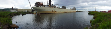
Decades before
water quality concerns led to environmental protection laws, maritime and
industrial activities left a legacy of contaminated sediment throughout the
Duluth-Superior harbor. These chemicals and heavy metals still remain today and
continue to pose a threat to the public and aquatic life. Cleaning up remaining
pollutants takes decades, as well, and progress is often measured one slip at a
time.
Or, in this
case, three slips. After researching options and gathering public input, the
MPCA selected final remedies for Slip 3,
Azcon/Duluth Seaway Port Authority Slip (photo above), and Slip C along the
city’s waterfront.
At a combined
estimated $9.9 million cost to complete the process from design through
construction, the selected remedies now move into the design phase. Ultimately,
construction will cover the contaminated sediment with about 3 feet of clean
material and require no offsite disposal. Barring unforeseen design or funding
delays, all three sites’ construction is expected to begin in 2018.
All cleanup
options considered were weighed against four goals:
- Minimize exposure to sediment contaminants that contribute to fish-consumption advisories
- Minimize exposure of aquatic organisms to contaminated sediments
- Preserve water depth to enable the current use of the slip
- Enhance deep-water aquatic habitat where possible
In partnership
with the U.S. EPA and the U.S. Army Corps of
Engineers, the MPCA will complete the remedial design at all three sites. This
effort will include environmental review and permitting that will provide
opportunities for additional public comment. Funding comes from the 2017
state’s bond funds and the federal Great Lakes Restoration Initiative.
The three slips
are located within the St. Louis River Area of Concern. This Area of Concern is
one of 43 Great Lakes locations in the United States and Canada where historic
shoreline alterations and industrial contamination caused impairments affecting
wildlife habitat and aquatic life.
These three
projects are part of a group of 10 contaminated sediment sites whose cleanup
will contribute to a healthier St. Louis River ecosystem.
For more
information, visit the MPCA’s St. Louis River Area of Concern
webpage or contact Project Manager Heidi Bauman at
heidi.bauman@state.mn.us, 218-302-6607 or 800-657-3864.
|
As Minnesota continues its statewide checkup of waters and
lists those failing to meet standards, some good examples of protective and
restorative work are starting to surface.
Water bodies that fail to meet standards are considered
impaired. The impaired
waters list represents an assessment of how well lakes and streams support
fishing, swimming, and other beneficial uses. This assessment is mandated by
federal law and requires a cleanup study for each impaired water body.
Success stories
For the first time, MPCA is proposing to remove an
impairment listing for PCBs. Fish sampled in the Red River of the North now
have PCB levels low enough to meet the standard for consumption, though some
impairments like mercury remain.
PCBs — polychlorinated biphenyls — were chemicals once used
as insulators in electrical equipment and for other purposes. They were banned
in 1979 because of their potential risks to human and environmental
health. Though scientists cannot
pinpoint the reasons for lower levels of PCBs in the Red River in northwest
Minnesota, it’s likely because PCBs have declined in the environment over the
past 38 years.
Additionally, the MPCA is proposing to remove these water
bodies from the list because of restorative actions to improve water quality:
- First Fulda Lake (Murray County) now has nutrient levels low enough to meet recreation standards.
- The Poplar River (Superior Hiking Trail Bridge to Lake Superior, in Cook County) is now clear enough to meet the standard for aquatic life such as fish.
- Bryant Lake (Hennepin County), Crystal Lake (Dakota County), Gem Lake (Ramsey County), McMahon Lake (Scott County), and Mitchell Lake (Hennepin County) now have nutrient levels low enough to meet recreation standards.
- Seven Mile Creek (Nicollet County) now has pesticide levels low enough to meet the standard for aquatic life such as fish.
Some common restoration actions include stabilizing
streambanks, holding back water long enough to let sediment settle out, and
better management of fertilizer.
New lakes, streams added to impaired waters list
There are, of course, new impairments proposed for the 2018
list. Highlights include:
- 201 streams and 23 lakes that cannot fully support aquatic life.
- 100 streams with elevated bacteria levels, most of them in the Red River basin in northwest Minnesota.
- 55 lakes and streams with high levels of nutrients.
- 32 water bodies with mercury levels in fish tissue that are too high to meet standards.
- 3 streams that fail to meet the chloride
standard designed to protect aquatic life.
Summary of numbers
In all, the number of impaired Minnesota waters on the draft
2018 impaired waters list totals 5,101 impairments, with 618 new listings,
covering a total of 2,669 water bodies across the state (many water bodies are
impaired by several pollutants). Minnesota is detecting more waters in trouble
because of its 10-year plan to study all 80 major watersheds in the state,
funded by the Clean Water, Land and Legacy Amendment. The MPCA has started this
study in all but a few watersheds.
While scientists find more impairments, the overall
percentage of impaired waters in Minnesota remains at 40%. The other 60% are in
good condition and need protective strategies to stay healthy.
Public meetings
The MPCA will hold a series of meeting around Minnesota
beginning Nov. 8. See details on the impaired
waters list webpage. A public comment period will follow later this year.
Related coverage
|
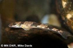
The Crystal Darter is an endangered
fish species, and as such is difficult for water monitoring crews to find while
sampling lakes and streams. But positive news of the Crystal Darter’s existence
and reproduction has emerged during recent sampling events, including the
summer of 2017.
Darters are a relatively unknown species of fish to most
people in Minnesota, but are found in streams, rivers, and lakes throughout the
state. Of the roughly 140 darter species found in North America, 14 exist in
Minnesota, with the Crystal Darter being perhaps the rarest and least known. Crystal
Darters are small, slender fish colored a pale yellow with several dark bars
along their sides. Once fully grown their length is typically 3-4 inches,
rarely growing past 5 inches.
Little is known about the life history
of the Crystal Darter within Minnesota. Specimens have been collected from rivers
in southeastern Minnesota, in moderate to large water bodies with clean water
and active flows. These rivers include the St. Croix, the Mississippi just
north of Red Wing, the Zumbro, and the Root.
Crystal darters are typically found
near sand and/or gravel substrates, which they use to their advantage by
burying their bodies while keeping their eyes exposed and ambushing prey as it
swims or drifts by.
Due to their rare existence, unknown
life history, and relatively low sampled populations, they were initially
designated a species of special concern within Minnesota in 1984. However, after
targeted surveys and analysis, the designation was elevated to endangered in
2013.
Minnesota Dept. of Natural Resources
(DNR) crews found Crystal Darters when sampling fish near Folsom Island in the
St. Croix River in August 2014 and June 2015. John Waters, DNR invasive carp
fisheries coordinator, and his crew found one Crystal Darter during each
sampling event.
Then, in late 2017, four additional
Crystal Darters were sampled in the same general area. Each darter was found
over sandy substrate in about 5-8 feet of water.
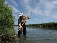
Similarly, Konrad Schmidt, a retired Minnesota
DNR biologist, found a single Crystal Darter over sand/gravel substrate in
roughly 3 feet of water using a seine.
Crystal Darter populations are very
susceptible and sensitive to environmental changes such as:
- Habitat degradation and modification
- Pollution
- Flow alteration
- Lack of connectivity
Populations are dependent on clean
gravel/sand substrates for reproduction and foraging, which makes them
sensitive to siltation often arising from erosion, logging, or agriculture.
Moderate to fast-flowing streams where
the Crystal Darters reside often have enough current to keep substrates clean.
However, flow alterations such as dams, slow the flow of streams allowing
sediments to settle to the bottom. Flow alterations often prohibit fish
passage, negatively affecting the darter’s (and other fish species’) ability to
disperse and establish new populations.
“Although Crystal Darters are a small,
relatively unknown fish to most in Minnesota, there is no denying their
uniqueness, not only in appearance but as well as lifestyle. In order to ensure
this unique species does not become extinct in Minnesota, care should be given
to reduce sediments entering streams and limit blockages to fish passage where
known populations exist,” said Tony Dingmann, MPCA biologist.
For more information on the Crystal Darter
and other rare fish species in Minnesota, visit the DNR
website.
|
Our state’s
namesake river, the Minnesota, tells a story different from the general perception
of good water quality in Minnesota’s lakes and rivers.
The Minnesota
River story is one of unique geography, many challenges to water quality from
surrounding land use and development, and dedicated efforts by many to make it
better.
The Minnesota
River begins at Big Stone Lake in western Minnesota, and flows 335 miles across
the southern third of the state to its confluence with the Mississippi River at
Fort Snelling.
Overall, the
Minnesota River is suffering in water quality, according to a recent MPCA study based on recent water monitoring and
decades of research. Sediment clouds the water, phosphorus fuels algae growth,
nitrogen and bacteria pose health risks.
Too much water
flowing into the river plays a big part in all these problems. There’s more
rain, more artificial drainage, and not enough places to store this water.
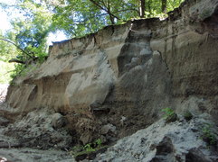
Worse yet, the landscape is naturally vulnerable to erosion.
“There are no
magic solutions. Government alone cannot solve this. This study informs us to
focus our actions, and people must work together to find solutions,” said Glenn
Skuta, director of the MPCA Watershed Division.
As part of its
statewide checkup of lakes and streams, the MPCA studied the entire length of
the Minnesota River. Once a massive, prehistoric river, today its remnant
strains under pressure from geography, surrounding land use and changing
climate. The Minnesota River basin provides fishing and other recreation for
much of southern Minnesota. But it’s also the biggest contributor of sediment
and nutrient pollution to the Mississippi River in Minnesota. And nitrate
levels are a growing concern because of the Minnesota River’s influence on
drinking water in the Mankato area.
There are some
signs of progress. Many farmers are exploring and using conservation practices
such as minimum tillage, cover crops and building soil health. The fish
population is generally healthy, though there are concerns about aquatic
insects that are food sources for fish. Cities and industries have improved
wastewater treatment, vastly reducing the phosphorus they discharge to the
Minnesota River basin. Local watershed organizations help landowners with water
quality projects such as buffer strips and grass waterways.
But there is
still more to do if Minnesota’s namesake river is to meet water quality
standards designed to protect river life and recreation.
Special report in
the Mankato Free Press: Torrential
flows threaten area rivers
|
The U.S. EPA recently approved Total
Maximum Daily Load (TMDL) study reports for the following watersheds. These
studies determine the total amount of a pollutant that a water body can receive
on a daily basis and still meet water quality standards.
Ramsey-Washington
watershed: Stormwater and erosion controls needed to help lakes and streams
According to the TMDL and related studies by the MPCA and its
partner, the Ramsey-Washington
Metro Watershed District (RWMWD), parts of this metro watershed
are polluted as a result of stormwater runoff, internal loading, and streambank
erosion. In two lakes and two streams, pollution may inhibit recreational
activities, harm aquatic insects and fish, or cause high levels of E. coli
bacteria, which can be harmful to human health.
The RWMWD is located in eastern Ramsey County and western
Washington County and encompasses portions of a number of communities including
White Bear Lake, Vadnais Heights, Gem Lake, Little Canada, Maplewood, Landfall,
North St. Paul, St. Paul, Oakdale, Woodbury, Roseville and Shoreview. The MPCA,
RWMWD and local groups are recommending a number of actions including:
- Reducing streambank erosion
- Reducing in-lake nutrients
- Improving stormwater management to restore and protect
waterbodies
The MPCA approved the associated Watershed Restoration and
Protection Strategies (WRAPS) in August 2017.
Rum River watershed:
Most waters healthy but some in trouble
The Rum River
watershed in northern Minnesota starts at Lake Mille Lacs. While
most of the waters studied here are in good shape and need protection, some
waters are in trouble, according to the TMDL and WRAPS reports. Six streams have high bacteria or low dissolved oxygen
levels, meaning they may not be fishable and swimmable at times. Ten lakes,
mostly in the southern half of the watershed, have high levels of phosphorus
that cause algal blooms.
The Rum River Watershed stretches from Lake Mille Lacs in the
north to the confluence with the Mississippi River in the city of Anoka.
The watershed covers large portions of Aitkin, Mille Lacs, Isanti, and Anoka
counties and covers smaller areas of Crow Wing, Morrison, Benton, Kanabec,
Chisago, and Sherburne counties as well as portions of the Mille Lacs Band of
Ojibwe Tribal land.
Some of the recommended strategies for this watershed include
protecting existing forestland, creating buffers in existing agricultural and
developed areas, restoring wetlands that have been altered, discouraging
additional drainage, promoting agricultural practices to reduce livestock waste
in lakes and streams, and ensuring septic systems are working as intended
throughout the watershed.
The MPCA approved the associated WRAPS in July 2017.
Pioneer-Sarah Creek
watershed: Many actions recommended to reduce pollutants
Lakes in the Pioneer-Sarah
Creek watershed are contaminated by phosphorus, and several of the watershed’s
streams have high levels of E. coli bacteria, according to the TMDL and WRAPS.
The pollution is severe enough to be harmful to aquatic insects and fish,
inhibit recreational activities, and pose health risks to humans.
Phosphorus in the lakes comes from manure, cropland runoff,
internal loading (agitation of phosphorus-laden lake sediments), and urban and
rural runoff. Bacteria in the streams is from livestock, wildlife, and human
waste.
The Pioneer-Sarah Creek Watershed, located in northwestern
Hennepin County, includes the communities of Greenfield, Independence, Loretto,
Maple Plain, Medina, and Minnetrista. The watershed’s diverse landscape is
dominated by undeveloped and agricultural land uses.
The MPCA, the Pioneer-Sarah Creek Watershed Management
Commission, and local partners are recommending many actions to restore and
protect water bodies in the Pioneer-Sarah Creek Watershed. Actions include
increasing buffers, reducing internal loading in lakes, improving manure and
pasture management practices, improving urban stormwater management, and
implementing livestock and agricultural best management practices.
The MPCA approved the associated WRAPS in July 2017.
Sauk River watershed: Several restoration strategies needed to
improve water quality
This TMDL report addresses four stream reaches with bacteria impairments and nine lakes with nutrient impairments.The Sauk River Watershed begins just outside of Alexandria. It
includes the cities of Sauk Centre, Melrose and Cold Spring, and it drains into
the Mississippi River near St. Cloud. Stressors to water quality in the river
system include low dissolved oxygen levels, high sediment and nutrient loads,
altered hydrology and lack of habitat.
Streambank restoration, shoreline and wetland protection, septic
system compliance, feedlot management, crop and manure management, city
stormwater management, and roadside erosion controls are among the strategies
proposed for the watershed.
The MPCA approved the associated WRAPS in April 2015.
|