|
Starting Monday, July 31, in Rochester, Gov. Mark Dayton plans
to host a series of 10 town-hall-style meetings across the state to
discuss water quality. They are part of the governor’s goal of improving
water quality 25% by 2025. A study by state agencies found about 40 percent of
Minnesota’s waters are polluted or impaired. Gov. Dayton has made improving the
state’s water quality a priority of his second and final term as governor.
All locations open at 5:30 p.m. with meetings starting at 6:30 p.m.:

- Rochester – July 31
- Mankato – Aug. 16
- Marshall – Aug. 17
- Crookston – Sept. 5
- St. Cloud – Sept. 6
- Ely – Sept. 12
- Bemidji – Sept. 13
- Minneapolis – Sept. 26
- Burnsville – Oct. 4
- Stillwater – Oct. 5
For details, see the Environmental Quality Board website.
Related media coverage:
|
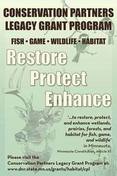
The Minnesota Dept. of Natural Resources (DNR) plans to open its Conservation
Partners Legacy grant cycles Tuesday, Aug. 1.
The
Conservation Partners Legacy grant program funds conservation projects that
restore, enhance, or protect forests, wetlands, prairies, and habitat for fish,
game, and wildlife in Minnesota. Funding for this grant program is from the Outdoor Heritage
Fund, funded by the Legacy Amendment.
The
DNR manages this reimbursable program to provide competitive matching grants
from $5,000 to $400,000 to local, regional, state, and national nonprofit
organizations, including government entities.
The
deadline for traditional/metro projects is Sept. 12. These grants range from
$5,000 to $400,000. The deadline for expedited conservation projects is Sept.
25. These grants range from $5,000 to $50,000.Use the CPL grant
cycle comparison chart to determine which grant cycle best fits your
project.
|
The Minnesota
Pollution Control Agency (MPCA) and local Little
Fork River watershed partners recommend restoring 100 miles of the
river from the damaging effects of excess sediment, according to a recently
released draft
report now available for comment through Aug. 23.
Intensive water
monitoring and assessment along the river found that soil erosion and pollution
runoff have created cloudy water conditions that can affect aquatic wildlife,
except for lake sturgeon that find it a perfect spawning habitat.
Located in the
Rainy River-Lake of the Woods River Basin, a majority of the watershed’s water
quality is considered good to excellent and lake water quality is very good in
15 assessed lakes. This is due to the watershed’s significant acreage of
forests and wetlands, as well as limited development pressure. As a result, the
Little Fork Watershed is one of Minnesota’s most treasured resources.
Protecting the
watershed’s water quality is also dependent upon the continued use of best
management practices when managing timber harvests and other forest activities
to prevent erosion and other detrimental impacts.
Comments on the
draft report should be sent to Mike Kennedy, 525 Lake Avenue South, Suite 400,
Duluth, MN, by email at mike.kennedy@state.mn.us, or by phone at 218-302-6629 or 800-657-3864.
Written comments
must include a statement of your interest in the report, a statement of the
action you wish the MPCA to take, including specific references to sections of
the draft report you believe should be changed, and specific reasons for your
position.
|
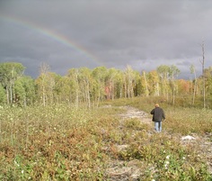
 Fish that spend most of their time in the Red River will, during spawning season, go searching for good habitat by swimming up the Red’s tributaries. Some of the best spawning habitat in the basin is located upstream in the Sand Hill River in what’s known as the beach ridge area. This area is a transition zone where thousands of years ago, a glacial lake called Lake Agassiz retreated and left behind gravel and other features that make fish today “hot to trot.” The problem for the fish was getting there.
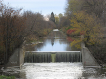
In more recent history, people have straightened and channelized the Sand Hill River’s natural shape. Doing this sped up the flow of water, increasing erosion and flooding. In an attempt to control these impacts, four concrete drop structures were installed in the 1950s (photo above right). These structures did not really do much to prevent problems, but instead caused several environmental issues, including preventing fish from accessing many miles of prime spawning habitat in the beach ridge area.
|
This issue came to light in
the Sand Hill River Watershed Biotic Stressor Identification
Report completed a few years ago. Scientists
from the MPCA conducted on-the-ground surveys to
record conditions in the watershed that pose a threat to aquatic life: fish,
aquatic insects and other creatures. The report showed many species of fish
were only found downstream of dams or other control structures, including
larger fish such as channel catfish, walleye, rock bass, goldeye, and sauger.
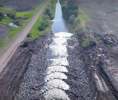
To help reduce erosion problems called head cutting and bank sluffing,
and at the same time address the fish barrier problem, local partners installed
a series of rock riffles bordered with riprap that replaced the concrete drop structures. (Photo above right shows the new riffles.) The stretches of riffles have
flat enough slope to allow fish passage upstream across each structure.
Reconnecting this substantial
spawning and rearing habitat will improve the composition and quality of the
fishery both in the Sand Hill River and the entire Red River basin. The work is
also expected to help efforts to reestablish lake sturgeon in the basin.
For details, including drone
footage of the riffles and riprap, see the project webpage
on the watershed district’s website or the full story on the MPCA website.
|
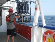
Federal scientists forecast that this summer’s Gulf of Mexico
dead zone – an area of low to no oxygen that can kill fish and other marine
life – will be about 8,185 square miles, or about the size of New
Jersey. This would be the third largest dead zone recorded since
monitoring began 32 years ago – the average Gulf dead zone since then has been
5,309 square miles, according
to a National
Oceanic and Atmospheric Administration news release.
This year’s predicted large size is due mainly to heavy May stream
flows, which were about 34% above the long-term average and carried
higher-than-average nutrient loads. The U.S. Geological Survey (USGS) estimates
that 165,000
metric tons of nitrate – about 2,800 train cars of fertilizer – and
22,600 metric tons of phosphorus flowed down the Mississippi and Atchafalaya
rivers into the Gulf of
Mexico in May. The USGS operates more than 3,000 real-time stream gauges, 60 real-time nitrate
sensors, and tracks trends in nutrient loads and
concentrations throughout the Mississippi-Atchafalaya watershed, which drains
parts or all of 31 states.
To
help reduce nutrient runoff, NOAA provides information to farmers through its Runoff Risk Advisory Forecasts, which
tell them when to avoid applying fertilizers to their croplands. Minnesota and
other states in the region have developed strategies
toward achieving the goal of a 45% reduction in phosphorus (by 2025)
and nitrogen (by 2040, with interim goal of 20% by 2025).
|
The
U.S. Environmental Protection Agency recently approved the Total Maximum Daily
Load study for the Elm
Creek watershed in the Twin Cities. This
study establishes the amount of each pollutant that a water body can accept
and still meet water quality standards.
Parts of this watershed are polluted as a
result of agricultural runoff, stormwater runoff, and streambank erosion,
according to the MPCA and its partners. In several lakes and streams, the
pollution is significant enough to inhibit recreational activities like fishing
and swimming, to harm aquatic insects and fish, or to cause high levels of
bacteria that can be harmful to human health.
The Elm
Creek watershed in Hennepin County includes the cities of Champlin, Corcoran,
Dayton, Maple Grove, Medina, Plymouth and Rogers. Diamond Lake, Rice Lake, Fish
Lake, Rush Creek and Elm Creek are
some of the water bodies within the watershed that are considered “impaired,”
or polluted. The MPCA, Elm Creek Watershed Management Commission, Three
Rivers Park District, and local groups are recommending a number of actions to
restore and protect water bodies in the Elm Creek Watershed.
The MPCA approved the Watershed
Restoration and Protection Strategies report for Elm Creek watershed in
December 2016.
Pete
Fastner recently retired July after 37 years of service with the MPCA. Many
know Pete for his dedicated work in the nonpoint program’s state Clean
Water Partnership grants and loans, and federal Section 319 grant programs.
Pete also coordinated the semimonthly Water Issues presentations at the MPCA
where numerous guest speakers share important information on environmental
topics.
The University of Minnesota Water Resources Conference will be Oct. 17-18
at the St. Paul RiverCentre. This annual conference presents innovative,
practical, and applied water resource engineering solutions, management
techniques, and current research about Minnesota’s water resources. Registration is
available online.
|