The
Minnesota Legislature continues its special session this week. It has yet to
take action on a bonding bill and other budget proposals. The proposed $990 million bonding bill includes
funding for several critical water protection efforts, including the St. Louis
River Area of Concern and wastewater infrastructure.
The
Legislature did pass an omnibus
environmental bill before its regular session ended, and the bill now awaits the governor’s
signature. Among the highlights:
- Increases in hunting and fishing license fees to provide new revenue for the Minnesota Dept. of Natural Resources to support these activities
- No major changes to the buffer law, though
landowners would gain an additional 8 months to comply with the law if filing a
plan with their SWCD by Nov. 1, 2017
Direct
appropriations include:
- Department of Natural Resources – $562.01 million
- Pollution Control Agency - $202.03 million
- Explore Minnesota - $30.01 million
- Board of Water and Soil Resources - $28.47 million
- Minnesota Zoo - $18.53 million
- Metropolitan Council - $17.08 million
- Science Museum of MN - $2.16 million
- Conservation Corps - $1.89 million
- School Trust
Administration - $1.1 million
While
that appropriation will allow the MPCA to continue most of its work at current
levels, the Clean Water Legacy funding bill included a 7% cut to the agency’s
Watershed Restoration and Protection Strategies (WRAPS) program. Agency leaders are still deciding how to address that decrease in funding.
In
other legislative action on environmental funding:
Also
this week, President Trump’s administration released its fiscal year 2018
budget that includes slashing the U.S. Environmental Protecting Agency by
one-third. This would severely cut EPA’s work force, clean water programs, and
clean air initiatives. The impact to Minnesota would include less funding for
Superfund sites and for the Great Lakes Restoration Initiative.
MPCA Commissioner John Linc
Stine serves as president of the Environmental
Council of States, a national nonprofit, nonpartisan association
of state and territorial environmental commissioners. The council released a statement
on the proposed federal budget, noting the need to carefully make budget adjustments to sustain programs that advance the
well-being of communities through environmental and public health protection.
Related
news stories:
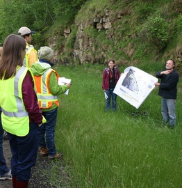
Scientists and other staff from the MPCA, DNR, U.S. Geological
Survey and Olmsted County toured karst features in southeast Minnesota May 23
to learn the latest research and ways to protect water resources in this
special landscape. Land use has a direct and sometimes immediate impact on
streams and groundwater here.
In karst, only a thin layer of soil covers the porous limestone
bedrock in many places, making it vulnerable to pollution. Water dissolves the
limestone, creating sinkholes, springs and disappearing streams, along with caves
and a complex drainage system underground. Contaminants on the surface can
easily reach groundwater used for drinking through fractures in the bedrock and
through water mixing above and below ground. This area is also popular for
trout fishing, which is supported by cold-water streams.
Highlights of the tour include:
- Research continues to be important for adopting laws on well placement and protections, as well as permitting conditions for residential development, feedlots, and wastewater treatment plants. The tour stopped at Altura, where one of the city’s wastewater ponds collapsed into a series of sinkholes in the late 1970s. The city now uses a different treatment system that continually discharges treated wastewater instead of using a pond system to treat the water and then release it twice a year.
- Streams that disappear underground can transport pathogens to fish hatcheries in the region and other water resources. Because the streams sink underground, the water is cold and pathogens can survive long-term.
- Karst features can hold water underground for many months and even years. This means water here has an age, some of it being “young” and some of it being “vintage.” Recent USGS research shows that nitrogen and herbicide levels continue to rise in some waters, despite changes in ag practices and the herbicide being taken off the market years ago. In contrast, some waters in the same region show a decrease in nitrogen and herbicide levels. The difference might be the age of water. This research is important to measuring how fast conservation practices can impact water quality.
For more information about karst and related water protection
efforts:
|
Pioneer-Sarah Creek watershed polluted by
phosphorus, bacteria
Lakes in the Pioneer-Sarah Creek watershed are
contaminated by phosphorus, and several of the watershed’s streams have high
levels of E. coli bacteria, according to recent MPCA reports. The pollution is severe enough to be harmful
to aquatic insects and fish, inhibit recreational activities, and pose health
risks to humans.
Phosphorus in the lakes comes from manure,
cropland runoff, internal loading (agitation of phosphorus-laden lake
sediments), and urban and rural runoff. E. coli in the streams is from livestock,
wildlife, and human waste. Bacteria can reach water bodies from stormwater
systems, manure-covered fields, malfunctioning septic systems, or feedlots.
The Pioneer-Sarah Creek Watershed, located
in northwestern Hennepin County, includes the communities of Greenfield,
Independence, Loretto, Maple Plain, Medina, and Minnetrista. The watershed’s
diverse landscape is dominated by undeveloped and agricultural land uses.
The MPCA, the Pioneer-Sarah Creek Watershed
Management Commission, and local partners are recommending many actions to
restore and protect water bodies in the Pioneer-Sarah Creek Watershed. Actions
include increasing buffers, reducing internal loading in lakes, improving
manure and pasture management practices, improving urban stormwater management,
and implementing livestock and agricultural best management practices.
The MPCA’s two reports on the watershed
include:
The agency is seeking comments from the
public on both reports through May 31. Submit comments in writing to Rachel
Olmanson, MPCA, 520 Lafayette Road North, St. Paul, Minnesota 55155-4194, or rachel.olmanson@state.mn.us. She is available to answer questions
at 651-757-2473.
|
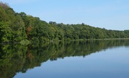
Most waters in Rum River
watershed in good shape, but some in trouble
A pair of studies are good news, bad news for the Rum River watershed in northern
Minnesota that starts at Lake Mille Lacs. While most of the waters studied here
are in good shape and need protection, some waters are in trouble. Six streams
have high bacteria or low dissolved oxygen levels, meaning they may not be
fishable and swimmable at times. Ten lakes, mostly in the southern half of the
watershed, have high levels of phosphorus that cause algal blooms.
Also, data going back several years show that many
pollutants in the river have decreased significantly, probably due to
wastewater treatment improvements. However, nitrogen and chloride levels have
increased, though levels still meet standards. Nitrogen can make water unsafe
for drinking for humans and can be toxic to fish. Chloride is also toxic to
fish and other aquatic life. In addition, the river’s nutrient levels are close
to being high enough to fail the water quality standard.
The Rum River Watershed stretches from Lake Mille Lacs in
the north to the confluence with the Mississippi River in the city of
Anoka. The watershed covers large portions of Aitkin, Mille Lacs, Isanti,
and Anoka counties and covers smaller areas of Crow Wing, Morrison, Benton,
Kanabec, Chisago, and Sherburne counties as well as portions of the Mille Lacs
Band of Ojibwe Tribal land.
Water bodies in the northern part of the watershed, which
is mostly forests and wetlands, are generally in great shape. As the Rum River
flows south, the land is more developed and pollutant levels increase. This
increase in pollutants with increase in development is a trend documented in
the surrounding Upper Mississippi River basin.
The two reports by the MPCA
and local partners include:
Some of the recommended strategies for this watershed
include protecting existing forestland, creating buffers in existing
agricultural and developed areas, restoring wetlands that have been altered,
discouraging additional drainage, promoting agricultural practices to reduce
livestock waste in lakes and streams, and ensuring septic systems are working
as intended throughout the watershed.
The agency is seeking comments from the public on both
reports through May 31. Comments may be submitted to Bonnie Finnerty, MPCA,
7678 College Road, Baxter, MN, 56425, or by email to bonnie.finnerty@state.mn.us. She is available to
answer questions at 218-316-3897.
|
Prescription for healthier Hawk Creek: Buffers, stormwater controls, changes in ag practices
The MPCA, Hawk Creek Watershed Project and local groups are recommending a number of actions to restore and protect water bodies in the Hawk Creek Watershed and surrounding tributaries directly flowing into the Minnesota River.
The Hawk Creek Watershed Restoration and Protection Strategy
(WRAPS) and Total Maximum Daily Load (TMDL) reports are available for public
comment through June 21.
The watershed is located in southwestern Minnesota in major
portions of Kandiyohi, Renville, and Chippewa counties. Hawk Creek is a major
tributary of the Minnesota River, entering about 8 miles southeast of Granite
Falls.
Generally, most streams and lakes in the watershed fail to
support swimming or fishing. Stream bank erosion and stormwater runoff create a
negative effect on water quality. Runoff from agricultural activities carries
excess phosphorus, sediment and bacteria into water bodies. These pollutants
degrade water quality and are harmful to fish and other aquatic life.
The TMDL report quantifies the pollutant levels, identifies
pollution sources, and proposes ways to return water quality to an acceptable
level.
The WRAPS report identifies impaired water bodies and those
in need of protection, and identifies the actions needed to achieve and
maintain water quality. For example, planting buffers along shoreland,
stabilized stream banks, and stormwater control projects will help improve
water quality. Agricultural practices called for include greater use of cover
crops, minimum or no tillage, temporary storage of water, and greater crop
diversity.
Comments on the reports should be submitted in writing by
4:30 p.m., June 21, 2017, to Michael Weckwerth, MPCA, 504 Fairgrounds Road, Marshall,
Minnesota 56258, or sent by email to michael.weckwerth@state.mn.us. He is
available to answer questions at 507-476-4267.
|
Note on commenting
Comments, which must be in writing, must indicate whether they pertain to the TMDL or WRAPS report. They should clearly state the action you wish the MPCA to take, including references to sections of the report that you believe should be changed; and provide specific reasons supporting your position.
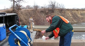
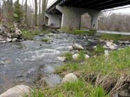
State and local water quality scientists
will be checking the health of the Redwood
and Cottonwood
river watersheds in southwest Minnesota this spring and summer.
The MPCA, Dept. of Natural Resources (DNR),
and Redwood-Cottonwood Rivers Control Area (RCRCA) staff will be collecting
samples and data to determine the health of local rivers, streams, and
lakes. The intensive monitoring approach includes examining the
populations of fish and other aquatic life in the rivers.
Funded by the voter-approved Clean Water
Legacy Act, the MPCA and partners use a "watershed approach" to
restore and protect Minnesota's rivers, lakes, and wetlands.
The watershed
approach focuses on a watershed's condition as the starting point for water
quality assessment, planning, implementation, and measurement of results. The
MPCA plans to assess the conditions and trends of Minnesota’s waters in a
10-year cycle.
During the cycle, the state's 80 major
watersheds are studied to assess water quality, set goals for improvement, plan
improvement projects, take actions designed to restore or protect water
quality, and measure results. When a watershed's cycle is completed, a new
cycle of evaluation, prioritization, and targeting goals begins.
|
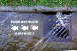
Stormwater runoff is a leading source of water pollution. Managing stormwater from urban areas is important for reducing pollutants running off into lakes and rivers. Minnesota’s MS4 program – Municipal Separate Storm Sewer System – is designed to reduce pollutants in runoff through a permitting program that requires best management practices.
Communities of a certain size and location must obtain an MS4 permit from the MPCA. The agency is proposing to add 20 more municipalities to the stormwater program, with their applications on public notice through June 1:
- City of Albertville
- City of Bayport
- Blue Earth County
- Buffalo-Red River Watershed District
- City of Eagle Lake
- City of Hanover
- City of Isanti
- City of Lake City
- Mankato Township
- Minnesota Correctional Facility – Stillwater
- Minnesota State University – Mankato
- City of Morris
- City of Oak Park Heights
- City of Rogers
- City of Skyline
- South Bend Township
- City of St. Augusta
- City of St. Francis
- VA Medical Center – St. Cloud
- City of Wyoming
|
A recently-released study shows that soil and water
conservation districts (SWCDs) are part of a $411 million industry that
supports more than 3,300 Minnesota jobs. The state study analyzed the economic
impact of the National Resources Conservation Service, Minnesota Board of Water
and Soil Resources, the Farm Service Agency's Conservation Reserve Program, and
SWCDs.
Specifically, the 2016 study found that SWCDs contribute about
635 jobs to Minnesota's economy and create $68 million in economic activity.
“The best part about the economic impact of SWCDs is that it
can be felt in every region of the state," said LeAnn Buck, executive
director of the Minnesota Association of Soil
and Water Conservation Districts. "We are proud to have a boots-on-the
ground presence in every Minnesota community, working with landowners on a
voluntary basis to improve water quality and soil health."
The study was conducted using Impact Analysis for
Planning software, a trusted model to estimate economic impacts. The results
were analyzed and approved by the U.S. Department of Agriculture. This is the
first-ever economic impact study of conservation delivery partnership's work in
Minnesota.
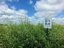
Landowners
have a new option to protect their environmentally sensitive cropland with the
introduction of the Minnesota
Conservation Reserve Enhancement Program (MN CREP). This program kicked off
May 15 and will accept applications until funding is exhausted.
MN
CREP is a voluntary state-federal program designed to improve water quality and
habitat conservation. It will protect and restore up to 60,000 acres of
marginal cropland across 54 southern and western Minnesota counties, using
buffer strips, wetland restoration and drinking water wellhead protection.
Native
plantings on those acres will filter water, prevent erosion and provide
critical habitat for countless grassland species including badgers, meadowlarks
and monarch butterflies.
“This
is a milestone in conservation for Minnesota,” according to John Jaschke,
executive director of the Minnesota Board of Water and Soil Resources (BWSR).
“It targets the most critical acres and will provide water quality and habitat
benefits for generations.”
The
program is funded with approximately $350 million from the U.S. Department of
Agriculture (USDA) and $150 million needed from state sources including: Clean
Water Fund, Outdoor Heritage Fund, Capital Investment (bonding), and the
Environment and Natural Resources Trust Fund. MN CREP is administered by the
Farm Service Agency (FSA) and BWSR, but involves numerous partners including
Minnesota Department of Agriculture, DNR, Department of Health and MPCA as well
as local Soil and Water Conservation District (SWCD) staff. MN CREP is also
supported by a coalition of more than 70 state and national organizations and
groups.
“Minnesota
is at a crossroads in conservation,” said Jaschke. “The state is facing serious
water quality challenges and we’re losing hundreds of thousands of acres of
grassland through expiring CRP. MN CREP isn’t the whole answer, but it plays an
important role in addressing both of these issues.”
Landowners wanting to learn more about MN CREP can contact their
local FSA/Natural Resources Conservation Service/SWCD office.
|

The MPCA’s Feedlot
Update newsletter is changing to a new name: Agriculture Stewardship -
Land, Water, Livestock. A continuation of the Feedlot Update newsletter, it
will offer wider news coverage of ag and water quality issues. Going forward,
the Feedlot Update newsletter name will remain in use on a quarterly or
as-needed basis. Launched in 2002, the newsletter currently goes to 2,331
recipients among livestock and crop producers, organizations, and agency staff.
You can log into our newsletter
subscription service to see all MPCA newsletters, and choose which ones you
would like to receive, or review your current selections. We welcome your ideas
and feedback. Thanks for your interest! Contact: Forrest Peterson, 320-441-6972,
forrest.peterson@state.mn.us.
|
|