|
April 2017
The Basin Alliance for the Lower Mississippi in Minnesota
(BALMM) will meet Wednesday, April 19, from 9 a.m. to noon at the People’s
Energy Cooperative, 1775 Lake Shady Ave. South in Oronoco, Minn.
Agenda as follows:
- 9 a.m.: Water Sustainability Efforts – Todd Osweiler Rochester Public Utilities
- 10:15 a.m.: Break
-
10:30 a.m.: Forever Green – Donald Wyse, professor of agronomy and plant genetics, University of Minnesota
- 11:30 a.m. – Updates from members
- Noon: Adjourn
At the April 19 BALMM meeting, Donald Wyse, agronomy and
plant genetics professor with the University of Minnesota-St. Paul will speak
on the Forever Green Initiative,
part of a broad effort to improve water quality in the Mississippi River and
Great Lakes Basin.
Dr. Wyse teaches and conducts research on invasive plant
management, cropping system development, plant breeding and new crop
development. His research efforts focus
on the development of perennial cropping systems, cover crop systems, prairie
polycultures, and their impact on soil and water quality.
He was the founding director of the Minnesota Institute for
Sustainable Agriculture, initiated the development of the Regional Sustainable
Development Partnerships, was founding director of the Midwestern Cover Crop
Council, and currently serves as co-director of the Center for Integrated
Natural Resources and Agricultural Management.
Recent activities of the center have led to the development
of the Mississippi River-Green Land,
Blue Water Initiative. This initiative is a consortium of universities,
state and federal agencies, and non-government groups that have organized
efforts to add perennial and winter annual crops to agricultural landscapes
that will improve water quality in the Mississippi River and Great Lakes Basin.
Dr. Wyse organized, and now leads, the Forever Green Initiative which is
Minnesota’s primary component of the Green Land-Blue Water program.
|
The U.S. Environmental Protection Agency (EPA) recently approved restoration studies for the Cannon and Root River watersheds. These studies, known as Total Maximum Daily Loads (TMDLs), establish the total amount of pollutants that water bodies can accept and still meet water quality standards. The studies also identify the sources of pollutants and ways to reduce their levels.
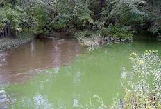
Cannon watershed provides high quality streams, but some suffering from pollutants
The Cannon River watershed in southeastern Minnesota provides high-quality streams that are valued for trout fishing and other recreation. However, some parts of these streams suffer from bacteria levels that may make the water unsafe for swimming, soil and sediment that cloud the water, phosphorus levels that can cause frequent algal blooms, and nitrate levels that may stress aquatic life like fish.
The Cannon River watershed drains 946,440 acres, most of it used for agriculture, and consists of two river systems: the Cannon and the Straight.
This watershed provides drinking water for households and industry, habitat for aquatic life, habitat for wildlife, and many recreational opportunities. The Cannon River is designated as a Wild and Scenic River starting downstream of its confluence with the Straight River in Faribault. The watershed has many lakes, along with trout streams that attract many local and Twin Cities residents for fly fishing.
For the lakes and streams in the watershed to meet water quality standards, the reductions in pollutants need to come from both point sources, such as wastewater from a city, and nonpoint sources such as sediment that washes from the landscape during storms. The TMDL report outlines strategies to reduce pollutants, such as agricultural practices to reduce runoff and erosion, manure runoff controls, sewer system upgrades, limits on wastewater discharges, and urban stormwater controls.
The TMDL is part of a larger Watershed Restoration and Protection Strategies report, which was approved by the MPCA in October 2016.
|
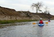 Root River watershed also provides high quality streams, but some need help
The Root River watershed in southeastern Minnesota provides high quality streams for trout fishing and other recreation. However, some parts of streams suffer from bacteria levels that may make the water unsafe for swimming, soil and sediment that cloud the water, and nitrate levels that may stress aquatic life like fish.
At 1,670 square miles, the Root is one of the largest watersheds in Minnesota, and touches six counties.
The TMDL study identifies pollutants in the Root River and tributaries, determines the reductions needed, and recommends actions to take like planting cover crops and reducing runoff.
This area of Minnesota is vulnerable to pollution because of its karst landscape. In karst, only a thin layer of soil covers the porous bedrock underneath and allows pollutants on the land to easily reach groundwater used for drinking. In a karst landscape, where caves and sinkholes are common, streams and groundwater mix as water moves through the bedrock. Because of karst, there are no lakes in this watershed.
The TMDL study is part of a larger Watershed Restoration and Protection Strategies (WRAPS) report, which was approved by the MPCA in November 2016.
|
The DNR is offering several River health and restoration workshops this summer:
- June 19-23 in Fergus Falls: Fundamentals of river science
- July 24 - Aug. 3 in Whitewater State Park: River monitoring and assessment
- Sept. 11-21 in Fergus Falls: River restoration: Design and application
The workshops will teach the fundamentals of stream science including: Fluvial geomorphology, hydrology, connectivity, biology, and water quality, and educate attendees in natural channel design techniques and approaches that ensure long-term health and stability. To register or for questions contact Amy Childers, amy.r.childers@state.mn.us. - 2017 Workshop flyer.
|