A discussion on civic engagement led off the fifth Watershed Professionals Network event Nov. 15 in Redwood Falls. Nearly 30 watershed organization and agency staff shared ideas and experiences about getting citizens more involved in water quality projects. Most watershed organizations are doing a variety of outreach activities. Civic engagement can range from citizens helping with monitoring, clean-ups, or rain garden and shoreland projects, to more in-depth involvement in decision-making, planning and policy. For more information, see the Civic Engagement webpage. Another resource is the 34-page report, " Psychology of Sustainable Behavior."
Also at the meeting
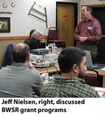
Jeff Nielsen and Steve Woods of BWSR gave an overview of Clean Water Fund opportunities.
Susie Carlin gave an overview of Blue Thumb, a program created by the Rice Creek Watershed District to encourage homeowners to use practices such as rain gardens and native plants to improve water quality. Blue Thumb website offers many promotional resources for use by anyone.
Dan Nadeau, Jerad Bach, and Vanessa Glieden Henjum showed slides of shoreland and riverbank projects. Available presentations will be posted on the Watershed Professionals Network webpage.
Megan Ulrich, Upper Sioux Agency, joins the Watershed Network planning committee, in place of Joel Wurscher, who is taking a position as soil conservation technician with NRCS in Nicollet County.
|
|
 |
A full house is expected at the "Water Quality Goals" public meeting Dec. 6 at the Mankato City Center hotel. This is being promoted as a "citizen-led conversation" focusing on the Mississippi, Minnesota, and Blue Earth rivers. After a short overview of the water quality goals, based on Total Maximum Daily Load projects, facilitators from InCommons will lead small group discussions. The event will wrap up with small group reports and discussion of next steps. The program will start at 5 p.m. with a social hour and dinner, free of charge to participants. With seating limited to about 100, pre-registration is required by calling 1-877-269-2873. See more information on the CURE webpage.
Move over HSPF and SWAT....here comes GSSHA. Gridded Surface Subsurface Hydrologic Analysis is a powerful, complex model for developing highly detailed information about watershed hydrology. At the Shakopee Creek Headwaters Project meeting Nov. 17, Greg Eggers, DNR and formerly with the Army Corps of Engineers, described a GHHSA modeling study under way in three small sections of the watershed around West Norway Lake. While the other models - Hydrologic Simulation Program Fortran and Soil and Water Assessment Tool - can provide a more general analysis, GSSHA analyzes grids down to 0.22 acres in area. Data inputs include Lidar (light detection and ranging), soil surveys, aerial photos, and flow monitoring. The extent of subsurface tiling is a major area where more information is needed. Implementing GSSHA over an entire watershed or basin would be very expensive, but results from smaller-scale projects can be used to inform the more general models, Eggers says. The ultimate goal in the Minnesota River basin is to develop a web-based decision support system for targeting appropriate best management practices. For more information, contact Greg at greg.eggers@state.mn.us, 651/259-5726.
A presentation and discussion about three Total Maximum Daily Load (TMDL) studies for turbidity took place at the combined policy and technical committee meeting of the Greater Blue Earth River Basin Alliance (GBERBA) Nov. 18 in Mankato. The reports soon will be be on public notice for the South Metro Mississippi, Minnesota River, and Blue Earth River turbidity TMDLs. After a brief overview of the studies, the audience divided into small groups to discuss individual sub-topics: Water storage-conservation drainage, cost-sharing, urban stormwater, tile outlets, and Clean Water Legacy funds. The three projects will be the focus of a public meeting Dec. 6 at the City Center hotel in Mankato.
Warren
Formo, director of the Minnesota Agricultural Water Resources Coalition, was
the keynote speaker at the Friends of the Minnesota Valley 20th annual dinner Nov.
16. His message focused on innovations in agriculture, producers and water
quality. He talked about transitioning to modern farming, Discovery Farms and
that agriculture has a role in improving water quality.
Three
awards were presented: Former senator and now DNR Regional Manager Dennis
Frederickson won the Carlson-Minge award for his work in the Minnesota
Legislature on the Minnesota River. Warren received a leadership award for the
MAWRC’s work in agriculture and water, and Leonard Binstock won an award for
his work on the conservation drainage workshops throughout the state.
Other
attendees included Greg Genz, communications manager at the Lock and Dam 3
project, and river barge deckhand in the early 1970s with a good historical
knowledge of the river; Sever Peterson from Eden Prairie and Sever’s Corn Maze;
also, Patrick Moore, Scott Sparlin, David Minge, John Hickman, and Jon Carlson.
Hickman and Carlson produced the River Revival documentary on the Minnesota
River that aired on KARE 11 earlier this year. – Larry Gunderson
|
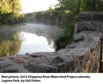
The 2012 Chippewa River Watershed Project Photo Contest
Calendars are here. Call or email Jennifer Hoffman for your free copy. Nineteen
photographers submitted a total of 45 photos. The Chippewa
River Watershed Project chose an independent review committee to judge the
photos and a winning photo was selected for each month.
Winning Photographers:
January-Cathy Jakobs, Montevideo
February-Kimberly DeMorett, Glenwood
March-Stacy Hanson. Woodbury
April-Stacy Hanson, Woodbury
May-Faith Anderson, Starbuck
June– Michael V. Naas, Mendota Heights
July– Mary Bergo, Montevideo
August-John DeMorett, Glenwood
September-Gail Felton, Montevideo
October-Rodney Willms, Brooklyn Park
November-Joyce Hagberg, Glenwood
December-Gail Felton, Montevideo
Best In Show– Gail Felton, Photo of the Chippewa River in Lagoon
Park in the City of Montevideo
- Jennifer Hoffman, 320-269-2139, jennifer.hoffman@chippewariver.org.
|
|
 |
The MPCA's Citizen Water Monitoring Programs (CMPs) has launched a web-based application for citizen water monitoring volunteers to access Individual Site
Reports online. In the past, the programs compiled reports and mailed them to
each individual volunteer. The new application saves time and money for the
program, and adds convenience and enhanced data access for volunteers. The new tool is available
on the MPCA website.
Minnesota
Department of Agriculture has $1,050,000 available for research related to agriculture and water quality. Funding is
available to support researchthat helps quantify
agriculture’s impact on water resources and research that evaluates the
costs and benefits of specific best
management practices. Any
organization, research entity, or individual can apply for these funds. Project
proposals are due Dec. 9, 2011. Information
is available in the State
Register on page 447.
To request proposal instructions and
to receive application materials, please call, e-mail, or write for the
full RFP which will be sent free of charge. All inquires should be addressed
to: Minnesota
Department of Agriculture, Adam Birr, Impaired Waters Technical
Coordinator, 625 Robert Street N., St. Paul, MN, 55155. E-mail: adam.birr@state.mn.us. Phone: 507-206-2881. For more
information about MDA’s Clean Water Research Program, supported research
projects and research priorities, please check out MDA’s Clean Water Fund website.
During the next 10 years the MPCA will be conducting comprehensive watershed monitoring covering all 81 major watersheds. The first three have been completed: Pomme de Terre, Little Fork, and Sauk.
The focus
is to characterize the fish, macroinvertebrate, habitat and
water chemistry of the river and streams in the watershed and water chemistry
in lakes. Conditions in the Little Fork Watershed were found to be quite good,
while more problems were discovered in the Sauk and Pomme de Terre watersheds.
|
MPCA’s Watershed Data Integration Project (WDIP) is an ongoing effort to improve public and professional access to data pertaining to water resources management. In August 2011 WDIP added several new data
retrieval capabilities to MPCA’s public website, making it much easier to find and use data on waterbodies, assessments,
impairments, and restoration/protection strategy projects (including
TMDL studies). A Data tab has been added to the main tab bar at the top
of each web page. This tab displays the new Environmental Data Access
page, listing all MPCA program areas that offer online data retrieval
capabilities. Clicking “Surface Water Data” there displays a list of
links that includes the new data access tools created by WDIP. Another
method is via the new Watershed webpages.
Each of the major watershed pages contains links that display an
assessment unit list and an impairment list for that watershed. Other
links provide access to the general assessment unit search tool
described above and to the full Environmental Data Access menu of
surface water tools. |
|
 |
Montevideo American-News, 11/17/11
MPCA news release, 11/14/11
Star Tribune, 11/13/11
Dec. 6: Water quality goals: Minnesota, Blue Earth, Mississippi River, 5-8 p.m., Mankato City Center Hotel. Pre-register at 877-269-2873.
Watershed Projects
Watershed Districts
Joint Powers Boards and Associations
Citizen/Organizations
Watershed Network News
welcomes news from partners about funding opportunities, project updates and
events. Email your news to forrest.peterson@state.mn.us. Please
note that the MPCA has switched to a new service, called GovDelivery. To ensure
delivery of these messages, please add mpca@public.govdelivery.com
to your address book or safe sender list. Please forward this to any other
interested parties. Past issues are located on the MPCA Minnesota River Basin webpage |
|
 |
|