|
October 2016
The Basin
Alliance for the Lower Mississippi in Minnesota (BALMM) will meet
Wednesday, Oct. 19, from 9 a.m. to noon at the People’s Energy Cooperative, 1775 Lake Shady
Ave. South in Oronoco, Minn.
Agenda
as follows:
- 9 a.m.: Water/Ways - The Smithsonian Traveling Water Project,
Jennifer Tonko, program officer, Minnesota Humanities Center
- 10:15 a.m.: Break
- 10:45 a.m.: Landscape Stewardship Plans in Southeast
Minnesota, David Schmidt, The Nature Conservancy
- Noon: Adjourn
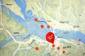
The next installment of the Smithsonian Water/Ways
exhibit runs through Nov. 13 at the Goodhue County Historical Society
in Red Wing. The exhibits reveal the central nature of water in our lives by
exploring how Americans use water, how water unites communities, how water
affects every element of life, and how Americans care for our water and
protect this valuable resource.
Local partners have also planned several
events related to the show in Red Wing.
Explore this collection
of stories about water to learn more about the community in and around Red
Wing.
The Water/Ways exhibition is part of the Smithsonian’s Museum on Main
Street program, which is a partnership of the Smithsonian Institution Traveling
Exhibition Service and state humanities councils.
In Minnesota, the project is led by the Minnesota Humanities Center, in
partnership with Minnesota Pollution Control Agency (MPCA), Minnesota
Department of Health, Minnesota Dept. of Natural Resources, Minnesota
Historical Society, and the American Water Works Association in Minnesota.
At the Oct. 19 meeting, Jennifer Tonko of the Minnesota Humanities
Center will talk about the Water/Ways project, how it has done so far in Spicer
and St. Peter, and how things are going in Red Wing. The exhibit will travel to
Lanesboro in January 2017.
Related news story: 'This
is about the importance of water' in the Rochester Post-Bulletin
|
The Nature
Conservancy develops landscape stewardship plans to take into account a
broader or “all lands” perspective that includes both shared community objectives
and individual management activities. To be successful, landscape stewardship
must be:
- Strategic and
collaborative
- Appeal to
stakeholder motivations and needs
- Manage for
results
- Encourage
flexibility in all activities
Successful
landscape stewardship builds agency, organizational, and community capacity
through collaboration, increases landowner trust of agencies and organizations
through streamlined management and communications, motivates landowners using
messages and activities that resonate with their needs, and supports the
application of science and knowledge through well-informed policies and
practices. Taken together, these activities work to make service delivery to
private landowners more effective and efficient.
At the Oct. 19
BALMM meeting, David Schmidt of The
Nature Conservancy will talk about plans that have been completed in southeast
Minnesota and how they can be incorporated into other regional efforts.
|
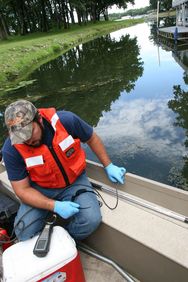 The MPCA is asking for your data to help assess the condition of
lakes and streams and build a national database of water quality.
The MPCA
is specifically interested in the following priority watersheds because the
agency will be determining whether these water bodies meet state water quality
standards in early 2017:
- Cloquet River
- Lac Qui Parle River
- Minnesota River - Headwaters
- Mississippi River - Grand Rapids
- Mississippi River - La Crescent
- Mississippi River - Reno
- Roseau River
- Upper Iowa River
- Upper Wapsipinicon River
- Vermilion River
- Winnebago River
The MPCA
is also looking for data on the Red River from the headwaters to the Canadian
border.
If you
have data from outside a priority watershed or one of these areas, the agency
will also accept it.
The
MPCA will use your data to:
- Help plan for future monitoring efforts including
what to monitor for and where to monitor.
- Identify pollutant “stressors” that are causing or
contributing to problems or threats to fishing, swimming, and
recreational uses.
- Evaluate the success of ongoing activities to protect
and restore water quality.
Deadline:
Submit project, lab, and field data now through Nov. 1.
Deadline:
By Dec. 15 you will need to review the data entered by the
MPCA.
Find out
more on the MPCA's surface water data website.
Your
role in collecting these data is important to Minnesota’s effort to identify
impaired waters, as well as those waters in need of additional protection.
Thank you for your help.
For more
information on submitting data:
- Nancy Flandrick, 651-757-2361 (St.
Paul, Duluth, Rochester, and Mankato regional offices)
- Jean Garvin, 651-757-2378 (Brainerd,
Willmar, Marshall, and Detroit Lakes regional offices)
|
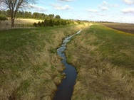 Altered
hydrology - changes to how streams flow naturally - is a common stressor to fish and other aquatic life throughout the Cedar River watershed, according to a report recently posted by the MPCA.
Closely related to the changes in nature's plumbing is lack of habitat in several parts of
this watershed in southeastern Minnesota and northeastern Iowa. Nitrate levels
high enough to negatively affect oxygen in fish and other aquatic life were
also a stressor in many streams and parts of the river.
The Cedar River runs about 300 miles, from its
headwaters in Dodge County to Louisa County in southeast Iowa, where it joins
the Iowa River and winds its way to the Mississippi River. About 42% of the
watershed lies in Minnesota, where it encompasses 454,029 acres in Mower,
Freeborn, Dodge, and Steele counties. This watershed covers prime agricultural
land with many streams and drainage ditches flowing into the river.
The watershed is fairly flat with shallow lakes and
rivers. Extensive drainage, to facilitate farming, has altered the hydrology of
the watershed.
The Cedar River in Minnesota is gaining popularity
for recreation with many water accesses, campgrounds, and fishing piers in the
watershed. Twenty-five miles of the river is designated as a Minnesota water
trail, from the village of Lansing (north of Austin at County Road 2) to the
Minnesota-Iowa border.
The Cedar River Watershed District is working to reduce flooding and improve
water quality of the rivers and its tributaries. It has launched several
projects, including water retention ponds, conservation practices on farmland,
wetland restoration, urban stormwater controls, ravine stabilization, and more.
The next
step in the watershed approach to gauging the health of the Cedar River is for
the MPCA to work with local partners and residents to develop Watershed
Restoration and Protection Strategies (WRAPS).
|
The University of Minnesota Water Resources
Conference will be Oct. 18-19 at the St. Paul RiverCentre. This annual
conference presents innovative, practical, and applied water resource
engineering solutions, management techniques, and current research about
Minnesota’s water resources. New programs this year include social justice in
water supplies and wetland protection vs. drainage rights. Registration
is available online.
|